| Previous :: Next Topic |
| Author |
Message |
ale_capone
Member


Joined: 22 Sep 2009
Posts: 720 | TRs | Pics
|
For those that don't subscribe. From bruce @ skyko.org . If you have questions about current access, you can always email Bruce.
If you go to the website, you can see the photos to go along with the text. Other updates on construction and other things.
Tuesday, May 11 - News Crew Visit, Road Progress
Sunday, with a fair amount of difficulty, I helped a courageous Everett Herald news crew in and out of here. Since the river was cooperating (just barely), they signed up for the whole adventure and we had a great visit here the cabin. When there is a resulting story, I will link to it here.
I spoke with the Operations Manager of Encore Environmental, a subcontractor currently here for the logging portion of the road project. The roughed in service route for heavy equipment is nearly complete to the upriver end. Our previous hillside trails for getting around the washouts are obliterated, and that entire area remains off-limits at all times. Fortunately, we will soon be in over the pass for the season.
Aerials are courtesy of Baring resident and drone pilot Kirk (Smokey) Bair.
Videos are forthcoming, with updates as the project continues to progress.
Monday, May 10 - Snow Melting Progress
In the climb from the North Fork side, the snow has receded beyond the next (third) switchbackthere are four. Almost immediately, it is too deep to drive though. The Beckler side has been driven to within two miles of the top. Similar has been reported theredeep snow begins right at the snow line. No one has been to the top yet. When we can make it, remember that the shaded, first stretch of the descent is usually still a problem, especially for climbing back out. I measured snow depths of two to three feet from above the final switchback to the top.
North Fork to the top are on Monday. The final three are a Beckler side climb on Saturday.
The June theory may not hold up, but we're still at the usual question... Will it be passable for Memorial Day weekend? A couple of weeks may do it. I don't think it will be sooner. More tree clearing is going to be needed after the meltdown. The condition of the gravel road will be terribleslow going due to ruts and potholes.
|
| Back to top |
  
|
|
Schroder
Member

Joined: 26 Oct 2007
Posts: 6722 | TRs | Pics
Location: on the beach |
|
Schroder
Member
|
 Mon Jun 07, 2021 10:27 am |
|
|
Article in today's Herald
Wilderness awaits beyond the washout on Index-Galena Road
After 15 years, construction has begun, restoring connection to the Wild Sky and Blanca Lake.
By Zachariah Bryan
Sunday, June 6, 2021 9:55am
INDEX If you look hard enough, you can see remnants of the Index-Galena Road.
Chunks of asphalt line the shores and lurk beneath the waters surface in a newly formed channel along the north fork of the Skykomish River.
When the road was built in 1911, people here probably didnt know that almost a century later it would be consumed by a raging Skykomish, destroying a half-mile stretch that would separate civilization from wilderness.
At the turn of the 20th century, the road was just a means to an end, and Index was still a town of dreams built on wood and stone, gold and silver.
In the new millennium, Indexs economy relies not on precious metals or timber, but recreation. The small mountain town of less than 200 is a stopping point for destinations in the Wild Sky Wilderness and beyond, including the ever popular jade green waters of Blanca Lake.
Since 2006, the sunken half-mile of road has divided people from hiking, kayaking, cabins, campgrounds and even mining claims on the other side of the wash-out. Instead, visitors and property owners and prospectors must take a 40-mile detour, via Beckler River Road and up the steep gravelly switchbacks of Jack Pass, a route that isnt open year-round.
The portion of Index-Galena Road between milepost 6.4 and 6.9 is the last piece left to fix after the flooding. The construction languished in a drawn-out planning process, while funding was secured, and while county officials figured out how to best replace the section of road. Three years ago, another obstacle arose, when the Sno-King Watershed Council appealed the projects shoreline permit to a state board, arguing the plans didnt adequately protect water quality according to county standards, or consider that construction would place fill dirt in the rivers migration zone, the range where the river could move naturally over time.
We feel that the North Fork Skykomish River is poised to make a shift to the south, wrote watershed council board member Bill Lider. If that happens, Lider argued, the County will have just wasted $30-million in taxpayer dollars.
Lider, a civil engineer, is a Lynnwood-based activist who frequently challenges county land-use decisions.
The appeal was struck down by the Shorelines Hearings Board, and again in February by a Thurston County Superior Court judge.
Its currently back in the state Court of Appeals, but the county has decided to move ahead with construction anyway. Public Works Deputy Director and county engineer Doug McCormick said the project has gone through extensive environmental review.
We prevailed, in both Shorelines Hearings Board and appeal in Thurston County court, he said. We feel very comfortable and confident in moving forward with this project.
After 15 years of waiting, trees are now being felled to make way for the new road.
This new one will go higher up the hillside and will be nearly a mile long, to avoid another bout with the Skykomish. Itll feature new culverts and a 180-foot-long bridge to help with fish passage, reinforced slopes and retaining walls. Crews will also remove chunks of the abandoned road, what environmental planner Crilly Ritz referred to as asphalt island. Thatll be replaced with new soil and more than nine acres of native plants and trees.
By relocating the new road out of the 100-year floodplain, we are reducing flood risk to the road and providing more room for the river, McCormick said in a statement. Every element of design and construction has been carefully vetted by the county and partnering state and federal agencies to ensure all environmental requirements are met and every consideration is made to minimize disruption to the river and its surrounding habitat.
Construction is estimated to be $20 million. That doesnt include the costs of planning, amounting to another $8 million. Federal funding accounts for most of the expense.
The road should be done by fall of 2023, or maybe sooner if weather cooperates.
Locals hope the new road will bring renewed interest to the region, and revitalize business in Index, the so-called gem of the forest.
The Flood
George W. Bush was still president, and Jay Inslee was about to win his sixth term in Congress, when Index saw one of the worst floods it had ever seen in November 2006.
The rivers in Snohomish County swelled to more than 33 feet, blasting a 30-foot hole through the French Slough levee.
Homes were hit hard by trees, logs and roots that came rushing downstream. Afterward, one man told The Daily Herald he evacuated his cottage, only to return the next day to find a 130-foot tree skewering his home like a toothpick through a martini olive.
A few miles up the road, the river gnawed the banks back 15 feet and devoured two cabins. The water worked like a saw blade as it destroyed homes along the river, a resident told The Herald.
Index saw the worst road damage in the county, officials said at the time.
The total damage estimate exceeded $20 million.
Bruce Kimball, a retired corporate pilot who lives most of the year in Kent with his family, is one of a handful of people who own property beyond the washout, which otherwise is mostly undeveloped land.
From his cabin by the river, Kimball had a front row seat to the flood. He said he liked to come out to witness the most dramatic weather patterns, for the highest rivers and deepest snows.
This flood was caused not by snow melt, but by continuous rain, he said.
It rained biblically, he recalled.
The river roared as it kept rising and rising, Kimball said. From inside his cabin, he could hear the sounds of boulders being tossed down the Skykomish, and logs crashing against the bridge. He stayed up for hours, unsure if he would be safe. He didnt go to sleep until he saw the water begin to recede.
The next day, Kimball saw that the road on either side of his cabin community had been destroyed.
He was stuck for weeks.
With time on his hands, Kimball decided to make a website to communicate with others who may want to know whats going on beyond the washout such as other property owners or hikers. He said hes been making websites basically since the internet was invented, and he was one of the only people in the area who had a satellite system, so he could connect to the internet.
And so Skyko.org was born.
The website, with its black Helvetica over white background, is utilitarian and sometimes funny. On it, he gives the latest on his communications with county officials and law enforcement; road and weather conditions; sightings of strangers and possible trespassers including the Russian campers and the Galena mystery man and the difficulties of getting propane. One Wednesday evening, he shared his woes about being unable to find chanterelle and morel mushrooms, likening the search to the snipe hunt he went on as a Boy Scout. (Later, he updated that he found chanterelles. There were two, but I shot the first one, he wrote. I was afraid it would get away.) In another post, he made a movie recommendation: Holes, starring Shia Labeouf.
Despite the road closure, Kimball spends about half his time at the cabin. He said he bought it in 2000 as his retirement activity.
To get there while the pass is closed, he navigates his way around the washed out portion of road, bushwhacks his way through the forest and hops on some rocks to cross parts of the river. Once he makes it back on the old road on the other side, its another couple miles of hiking.
As a property owner, Kimball has special permission to go to his cabin. The county is discouraging people from entering the active construction zone. Those hoping to take advantage of the recreational opportunities on the other side will have to go through Jack Pass, now open for the summer.
Openly carrying a 9mm handgun, Kimball sees himself as a kind of Lone Ranger character. He keeps an eye on the community and talks to any strangers he sees in an attempt to deter crime, whatever kind may come to these parts. As one of the only people with access to the internet, hes also one of the only people who can call 911 and communicate reliably with the cops.
Kimball is one of a few committed diehards who regularly cross the washout. Hes seen other property owners sell their cabins because they had no way to visit. Others dont come nearly as often as Kimball, or stay nearly as long.
By now, Kimball has mastered his arrival routine. Heat up the house, start up the electricity, power up the internet, make some French press coffee. He has a bazillion channels on satellite radio, but he only listens to two stations: Country, and country. And maybe some Elvis. He said he hunts and fishes and hikes sometimes, but mostly he whiles away his time by working on any one of his various projects like his upcoming hobby, ham radio. It could be a hit! he said. He likes to stay busy.
Kimball looks forward to the day that he can drive to his cabin on the Index-Galena. Now 70, hes unsure how many more years he can make the trek on foot. With the completed road, he could bring his family more often. And hes eager to share the natural beauty of the region with others.
The gem of the forest
Debbie Copple, director of the Sky Valley Chamber of Commerce, said shes been disappointed by how long its taken to replace the Index-Galena.
Without the road, its challenging to show off what the region has to offer, and to attract visitors. She noted the Wild Sky Wilderness was designated as a wilderness in 2008, but ever since, actually getting there has been a hassle.
Its been so long since the road was passable, Copple said she didnt think she could compare what it was like before to what it will be like after the road reopens.
In 2005, before the flood, an average of about 230 vehicles traveled Index-Galena Road daily and 530 on Saturdays, according to the county. That was before Instagram and TikTok were around to show millions of viewers what they were missing out on before #wanderlust and FOMO drove unprecedented hordes of people to the outdoors.
Sitting just a mile off of U.S. 2, Index might as well be invisible to many who drive by on the highway, on their way to other destinations.
With the road reopening, the small town will likely be treated to a new wave of weekend warriors.
Some business owners are counting on it, like Bill Corson. Recreation is his job.
In Index, his family owns the Outdoor Adventure Center, the River House and soon a newly renovated Bush House hotel.
He said he moved here in 2007 because of the scenery, the river and the wilderness. Staying at the historic Bush House, he said, was like staying in a small Yosemite Valley, with the sheer granite cliffs of the Index Town Wall dominating the scenery.
Copple said the view from her friends chicken coop is better than the view from most peoples houses.
To be honest, I think its the most picturesque community Ive ever seen, Copple said.
I just dont think you can see ugly up there. Its just a beautiful place.
Corson has fond memories of what lies beyond the washout, too, like Bear Creek Falls, where salmon can be seen migrating upstream. And the Skykomish here is especially clear, he said, opening up to wide vistas of the mountains, unlike any other river hes been on in the state and as a rafting guide, hes been on a lot of rivers.
In the Wild Sky Wilderness, he sees opportunity.
Where trails along the I-90 corridor have become saturated with people, as populations in Seattle and the surrounding suburbs keep growing, the Wild Sky has remained relatively undiscovered because of the closed road.
When people can finally visit with ease, theyll need to pick up last-minute supplies, such as food and wood, at the Index General Store. Theyll want a cup of coffee to perk them up for the journey ahead, or a beer to cool off after a long day outdoors. The River House offers the former; the Sand Bar offers the latter.
With recreational tourism comes jobs, Corson said. At the Outdoor Adventure Center, he said he went from up to 80 part-time employees in the summer before the washout, to less than 30 after. When the road is complete, he expects to increase his staff again.
Copple said she didnt want to see Index become overwhelmed by visitors. Its a small town, and people there like it that way, she said.
The goal is to strike a balance, Corson said.
As for Kimball, hell miss some aspects of living beyond the washout mostly by himself. Hell enjoy the convenience, but with that comes traffic, noise and other disturbances that havent reached his cabin in 15 years.
Hes learned to appreciate the isolation and the quiet.
You just wouldnt even believe how often I am the only human soul in this valley, Kimball said.
When the road reopens, therell be many more souls to join him.
Hes OK with that.
|
| Back to top |
|
|
Foist
Sultan of Sweat

Joined: 08 May 2006
Posts: 3974 | TRs | Pics
Location: Back! |
|
Foist
Sultan of Sweat
|
Mon Jun 07, 2021 10:42 am |
|
|
Thanks! Really nice work by that young reporter.
|
| Back to top |
|
|
Schroder
Member
Joined: 26 Oct 2007
Posts: 6722 | TRs | Pics
Location: on the beach |
|
Schroder
Member
|
Mon Jun 07, 2021 11:05 am |
|
|
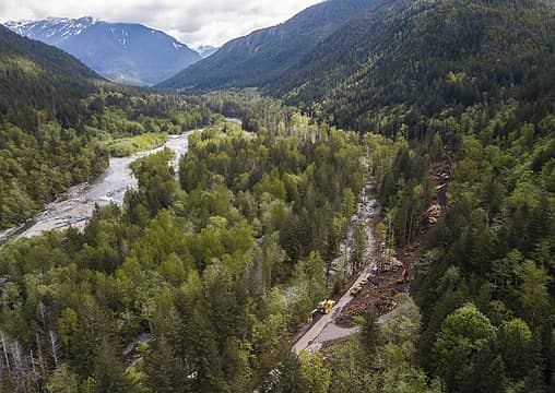 Construction of the new section of Index-Galena Road in Index. (Olivia Vanni / The Herald)
|
| Back to top |
|
|
slabbyd
Member
Joined: 21 Jun 2005
Posts: 293 | TRs | Pics
|
|
slabbyd
Member
|
Mon Jun 07, 2021 12:05 pm |
|
|
$28 million dollars for a stretch of whats basically FSR road...incredible. Love how the reporter addresses FOMO as a motivation for so many "FOMO drove unprecedented hordes of people to the outdoors."
|
| Back to top |
|
|
Schroder
Member
Joined: 26 Oct 2007
Posts: 6722 | TRs | Pics
Location: on the beach |
|
Schroder
Member
|
Mon Jun 07, 2021 12:54 pm |
|
|
| slabbyd wrote: | | $28 million dollars for a stretch of whats basically FSR road...incredible. |
$28 million doesn't buy much anywhere these days if you look at the cost of other transportation projects
|
| Back to top |
|
|
Foist
Sultan of Sweat
Joined: 08 May 2006
Posts: 3974 | TRs | Pics
Location: Back! |
|
Foist
Sultan of Sweat
|
Mon Jun 07, 2021 1:06 pm |
|
|
It's not a FS road. It's a paved county road. they need to construct a mile of entirely new, paved road in remote forest, plus remove huge chunks of concrete from the old road and replace with new soil and nine acres of plants and trees. $28 million seems like a bargain compared to what these things tend to cost nowadays.
|
| Back to top |
|
|
puzzlr
Mid Fork Rocks

Joined: 13 Feb 2007
Posts: 7220 | TRs | Pics
Location: Stuck in the middle |
|
puzzlr
Mid Fork Rocks
|
Mon Jun 07, 2021 11:00 pm |
|
|
It's not only money, it's jobs too :-). Over three years and accounting for some overhead that could be 80 jobs for the term. And at the end we get a road back. A good deal. Yay!
|
| Back to top |
|
|
Kim Brown
Member
Joined: 13 Jul 2009
Posts: 6899 | TRs | Pics
|
I wonder where Bill Lider will pop up next?
He's like the Whack-a-Mole game of access to the enjoyment of public lands.
"..living on the east side of the Sierra world be ideal - except for harsher winters and the chance of apocalyptic fires burning the whole area."
Bosterson, NWHiker's marketing expert
"..living on the east side of the Sierra world be ideal - except for harsher winters and the chance of apocalyptic fires burning the whole area."
Bosterson, NWHiker's marketing expert
|
| Back to top |
|
|
Stefan
Member

Joined: 17 Dec 2001
Posts: 5093 | TRs | Pics
|
|
Stefan
Member
|
Tue Jun 08, 2021 10:41 am |
|
|
Back when I was a young wippersnapper, we built roads for free! We just cut dem logs if they were in the way, and we put in the road. None of this court stuff and environmental things the good old days. You kids!!!
|
| Back to top |
|
|
slabbyd
Member
Joined: 21 Jun 2005
Posts: 293 | TRs | Pics
|
|
slabbyd
Member
|
Tue Jun 08, 2021 2:29 pm |
|
|
Well at $28 million dollars a mile youre going to loose a lot more access then youre going to ever recover.
|
| Back to top |
|
|
Frango
Member

Joined: 21 Nov 2012
Posts: 183 | TRs | Pics
|
|
Frango
Member
|
Tue Jun 08, 2021 8:48 pm |
|
|
Yep - Lider is kind of like a social disease - the gift that keeps on giving.
|
| Back to top |
|
|
Owler
Member
Joined: 09 Jul 2020
Posts: 45 | TRs | Pics
|
|
Owler
Member
|
Wed Jun 09, 2021 1:55 pm |
|
|
I think the article is right...Wild Sky Wilderness is pretty empty with the exception of Blanca. I did Benchmark/pass creek last summer on a weekend and saw very few people.
|
| Back to top |
|
|
Slugman
Its a Slugfest!

Joined: 27 Mar 2003
Posts: 16874 | TRs | Pics
|
|
Slugman
Its a Slugfest!
|
Wed Jun 09, 2021 4:33 pm |
|
|
Bill Lider, of the Pilchuck Audubon Society, the Sno-King Watershed Council, and the Complete and Utter Horsesh*t Committee. 
|
| Back to top |
|
|
Sore Feet
Member

Joined: 16 Dec 2001
Posts: 6307 | TRs | Pics
Location: Out There, Somewhere |
| Owler wrote: | | I think the article is right...Wild Sky Wilderness is pretty empty with the exception of Blanca. I did Benchmark/pass creek last summer on a weekend and saw very few people. |
Must have chosen the right weekend then. I went up there toward the end of July last year (on a weekend) and there were people at pretty much every campsite in the last two miles up to the summit of Benchmark, plus down on the bench near the tarns. I'm sure the comet being still visible at the time didn't help though.
|
| Back to top |
|
|
|
|
You cannot post new topics in this forum
You cannot reply to topics in this forum
You cannot edit your posts in this forum
You cannot delete your posts in this forum
You cannot vote in polls in this forum
|
Disclosure: As an Amazon Associate NWHikers.net earns from qualifying purchases when you use our link(s). |


