| Previous :: Next Topic |
| Author |
Message |
Martin S
Member


Joined: 06 May 2007
Posts: 181 | TRs | Pics
Location: Out in the perimeter, where there are no stars |
|
Martin S
Member
|
 Mon May 25, 2009 2:24 pm |
|
|
Mt. Lawson, in the southern Olympics, is a relatively obscure peak whose primary claim to fame is that it has 2521 ft of prominence, making it the 80th most prominent peak in the state. Reports from the only people I know who have been there (Roper et al and Klenke) include tales of difficult river crossings and steep, brushy, cliffy terrain and in general don't make in sound like much fun. Roper concluded his trip report with the question "Is there an easier way?" Dave Creeden and I set out this weekend hoping to find one, and I think we did.
On Saturday we made the long drive around to Lake Quinault and hiked 10 miles up the North Fork Quinault River trail. The trail was badly damaged by the two back-to-back 100 year floods a couple of years ago and hasnt been completely restored yet. The rangers may try to warn you away from that trail with tales of the destruction, but its not that bad if you dont mind a couple dozen windfalls across the trail and having to do some creative boulder hopping and log shimmying at several creek crossings. We made it all the way without having to do any fords. Still, the destruction wrought by the floods is quite a sight, and serves as a reminder that in the southern Olympics the term creek is not synonymous with babbling brook; it means something more like raging torrent capable of moving large boulders and leaving 6 ft diameter logs lodged in remarkable places.
We reached the area on the north side of Lawson where the previous parties had crossed the river and started looking for a place to cross, but the water level was simply too high. Fate smiled upon us and we found a log which offered a safe, dry crossing.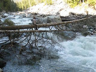 Dave crossing on the miracle log 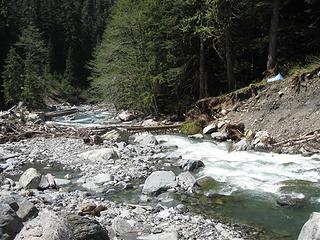 Log crossing and camp 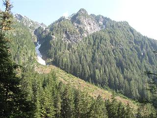 Lawson N side 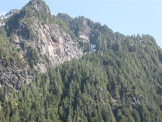 Upper route; steepest section is at right 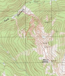 Route up hidden gully 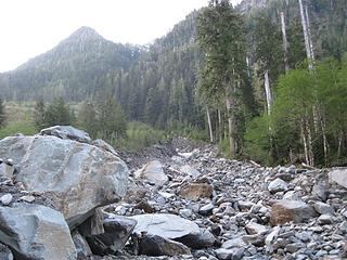 Starting up the stream beside the avalanch fan 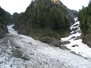 Gully fork at 2300 ft. Take the right fork. 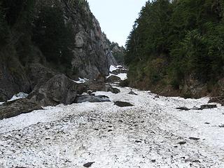 Looking up hidden gulley 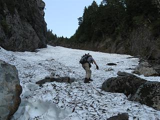 Ascending hidden gully 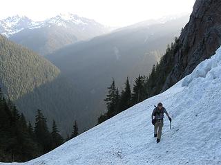 Right fork in the gully at 3700 ft 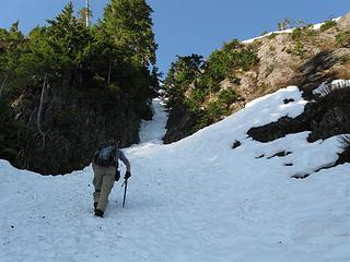 Snowfinger to crux 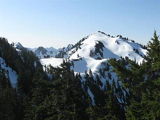 Summit area 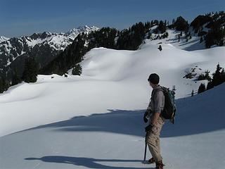 Nearing summit 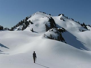 Fine cramponing up final 400 ft to Lawson summit 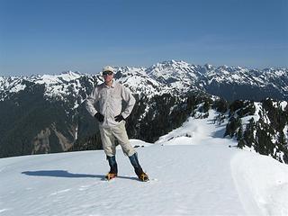 Martin on Lawson summit 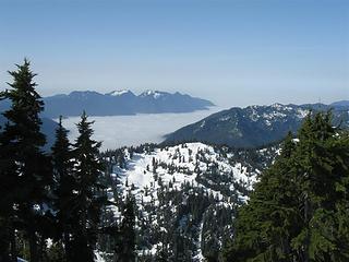 Marine layer filling Quinault valley 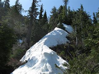 Ridge at 4200 ft 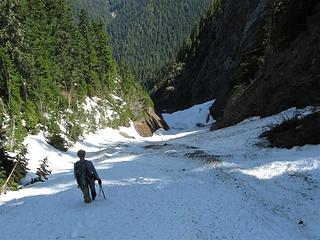 Descending 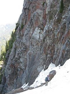 Descending 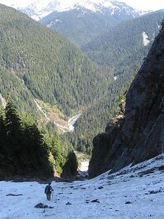 Descending 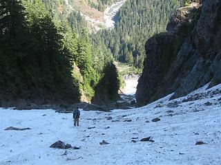 Descending hidden gully 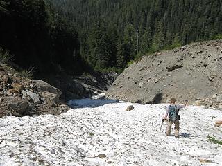 Descending stream gully
"nothing's for certain" took the elevator down
while "anything can happen" climbed the stairs
- Ryszard Krynicki
"nothing's for certain" took the elevator down
while "anything can happen" climbed the stairs
- Ryszard Krynicki
|
| Back to top |
  
|
|
Hoosierdaddy
Trophy Husband

Joined: 29 May 2003
Posts: 436 | TRs | Pics
Location: Little Norway |
Very, very nice! My kind of trip!!  In your second picture, I can see your shelter. What is it?
God, I am going to regret this someday!
God, I am going to regret this someday!
|
| Back to top |
|
|
iron
Member

Joined: 10 Aug 2008
Posts: 6392 | TRs | Pics
Location: southeast kootenays |
|
iron
Member
|
Mon May 25, 2009 3:58 pm |
|
|
| Martin S wrote: | Still, the destruction wrought by the floods is quite a sight, and serves as a reminder that in the southern Olympics the term creek is not synonymous with babbling brook; it means something more like raging torrent capable of moving large boulders and leaving 6 ft diameter logs lodged in remarkable places.
Dave crossing on the miracle log |
wow. that is indeed one heck of a miracle log!
|
| Back to top |
|
|
Ancient Ambler
Member

Joined: 15 May 2007
Posts: 1092 | TRs | Pics
Location: Bainbridge Island |
Awesome trip, TR and pix. Thanks for providing so many descriptive details and photos on your route.
|
| Back to top |
|
|
Magellan
Brutally Handsome

Joined: 26 Jul 2006
Posts: 13116 | TRs | Pics
Location: Inexorable descent |
|
Magellan
Brutally Handsome
|
Mon May 25, 2009 4:11 pm |
|
|
Great details, thanks for posting it Martin.
|
| Back to top |
|
|
Eric
Peak Geek

Joined: 21 Oct 2002
Posts: 2062 | TRs | Pics
Location: In Travel Status |
|
Eric
Peak Geek
|
Mon May 25, 2009 4:47 pm |
|
|
Great info Martin. I was actually thinking about suggesting this one for this past weekend but I figured that with the sun and warmth that the creek would just be running too high. I figured you probably headed off to another spring type P2000, perhaps Liberty, instead.
|
| Back to top |
|
|
Justus S.
Member

Joined: 17 Nov 2004
Posts: 1298 | TRs | Pics
Location: WA |
Very informative and great read, thanks.
|
| Back to top |
|
|
Martin S
Member
Joined: 06 May 2007
Posts: 181 | TRs | Pics
Location: Out in the perimeter, where there are no stars |
|
Martin S
Member
|
Mon May 25, 2009 6:56 pm |
|
|
Yup, that's Dave's Clip Flashlight. I had one just like it a few feet farther back in the woods. They're (supposedly) two-person tents, but he has a tendency to snore and I have a tendency to shove snoring tentmates into the river, so... two tents.
HJT, yes, I believe this is the perfect time of year for this route. Any earlier and you'd hit snow on the trail and risk avalanches in that gully; any later and the snow in the gully would be rock hard and discontinuous, and there could be brush to contend with up high. That said, the spring runoff is a bad time of year to plan on fording the river. We got lucky in finding that log.
"nothing's for certain" took the elevator down
while "anything can happen" climbed the stairs
- Ryszard Krynicki
"nothing's for certain" took the elevator down
while "anything can happen" climbed the stairs
- Ryszard Krynicki
|
| Back to top |
|
|
puzzlr
Mid Fork Rocks

Joined: 13 Feb 2007
Posts: 7220 | TRs | Pics
Location: Stuck in the middle |
|
puzzlr
Mid Fork Rocks
|
Tue May 26, 2009 1:06 am |
|
|
Wow, we get perfect Memorial Day weather and the astounding trip reports just keep rolling in. Nice job route finding. I see you walking down in all the "descending" shots -- no glissades?
|
| Back to top |
|
|
Stefan
Member

Joined: 17 Dec 2001
Posts: 5091 | TRs | Pics
|
|
Stefan
Member
|
Tue May 26, 2009 9:37 am |
|
|
Great going! great to hear you had a log crossing!
|
| Back to top |
|
|
silence
Member

Joined: 25 Apr 2005
Posts: 4420 | TRs | Pics
|
|
silence
Member
|
Tue May 26, 2009 11:03 am |
|
|
VERY NICELY DONE ... WAY TO GET ER DONE!!
PHOTOS
FILMS
Keep a good head and always carry a light bulb. Bob Dylan
PHOTOS
FILMS
Keep a good head and always carry a light bulb. Bob Dylan
|
| Back to top |
|
|
goats gone wild
Mr. Goat

Joined: 19 Aug 2007
Posts: 2524 | TRs | Pics
Location: Vampireville |
Well written TR and great pictures. I love reading off trail in the Olys reports.
Good job on finding the log and the navigation up the mtn.
.....leaving me wanting to return over and over in what ever capacity that may be, even if one day my knees are too old and I can only see the mountains from my porch.
Jason Hummel
.....leaving me wanting to return over and over in what ever capacity that may be, even if one day my knees are too old and I can only see the mountains from my porch.
Jason Hummel
|
| Back to top |
|
|
|
|


