| Previous :: Next Topic |
| Author |
Message |
GeoHiker
Rocky Walker


Joined: 26 Feb 2005
Posts: 6033 | TRs | Pics
Location: Off the Deep End |
|
GeoHiker
Rocky Walker
|
 Wed Jul 15, 2009 8:44 pm |
|
|
I've been itching to get up in the Sultan Basin and haven't seen any updates on the road conditions, so headed on up that way to check it out. The Road Closed sign at mile 10 is gone and you can drive to the registration area at Olney Pass. Road has been recently graded and is in excellent shape.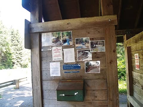 Registration booth at Olney Pass 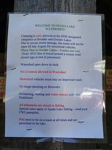 Spada Notice 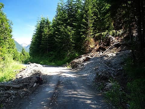 First slide/washout 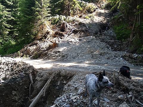 First washout/slide 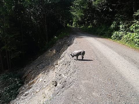 Rocky checking out the road damage. 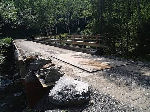 Temp bridge repair S Fork Sultan River. 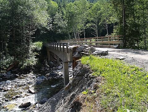 P7158317.JPG 
 Static Pt turnoff. 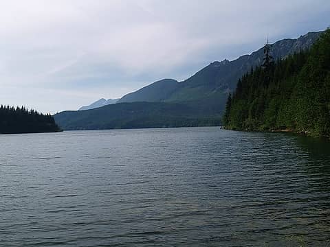 Spada Lake view 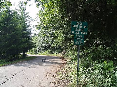 Opps, better get out the leash.  Spada Lake view
You call some place paradise, kiss it goodbye......Eagles
You call some place paradise, kiss it goodbye......Eagles
|
| Back to top |
  
|
|
Jimbo
Member

Joined: 14 Feb 2005
Posts: 1558 | TRs | Pics
Location: Arlington |
|
Jimbo
Member
|
Wed Jul 15, 2009 8:49 pm |
|
|
Most Excellent Geoman. I'll need to see how bad the bridge got creamed heading to the Kromona.
Guns only have two enemies; rust and politicians
Guns only have two enemies; rust and politicians
|
| Back to top |
|
|
mossy mom
Member

Joined: 29 Dec 2006
Posts: 1852 | TRs | Pics
|
They don't call it the Department of Nothing Remaining for nothing..
|
| Back to top |
|
|
GeoHiker
Rocky Walker

Joined: 26 Feb 2005
Posts: 6033 | TRs | Pics
Location: Off the Deep End |
|
GeoHiker
Rocky Walker
|
Wed Jul 15, 2009 8:57 pm |
|
|
Jimbo, if you look at the upper left on the registration board there are 2 pics of the bridge. It's gone. I walked up a bit of the road and it's been recently 4x4ed. Do you know how far you can go?
I forgot to add in my report. The Olney Creek road was graded for about 200 ft. and I could drive my Honda in about 1/2 mile. I pulled over and walked about 1/2 mile more. Big puddles aren't too bad. I could hear people shooting farther up, so I turned around. Have you been up that road recently and how far can you 4x4?
You call some place paradise, kiss it goodbye......Eagles
You call some place paradise, kiss it goodbye......Eagles
|
| Back to top |
|
|
Schroder
Member

Joined: 26 Oct 2007
Posts: 6740 | TRs | Pics
Location: on the beach |
|
Schroder
Member
|
Wed Jul 15, 2009 9:01 pm |
|
|
Thanks for the recon, GeoH 
|
| Back to top |
|
|
GeoHiker
Rocky Walker

Joined: 26 Feb 2005
Posts: 6033 | TRs | Pics
Location: Off the Deep End |
|
GeoHiker
Rocky Walker
|
Thu Jul 16, 2009 12:00 am |
|
|
No problem. I also went up the Shaw Lake road and you can go about 3 miles up to about the 1800 ft. level. I didn't go any farther, but the new road went up above. Looks like they are just getting ready to log.
Nice view from up there, so that road would make for a nice snowshoe, early season hike. I wonder if the old road is still passable?
You call some place paradise, kiss it goodbye......Eagles
You call some place paradise, kiss it goodbye......Eagles
|
| Back to top |
|
|
Hulksmash
Cleaning up.

Joined: 20 Apr 2008
Posts: 7113 | TRs | Pics
Location: Arlington |
|
Hulksmash
Cleaning up.
|
Thu Jul 16, 2009 12:10 am |
|
|
Wow that bridge approach got hammered.  The rock quarry is sorta close to Greider lake. It's at the end of a long spurr just past the second rec site. It's the only spurr that does not have the tank traps....it does have some deep water bars dug into it. So it is high clearance only.
"Bears couldn't care less about us....we smell bad and don't taste too good. Bugs on the other hand see us as vending machines." - WetDog
Albuterol! it's the 11th essential
"Bears couldn't care less about us....we smell bad and don't taste too good. Bugs on the other hand see us as vending machines." - WetDog
Albuterol! it's the 11th essential
|
| Back to top |
|
|
GeoHiker
Rocky Walker
Joined: 26 Feb 2005
Posts: 6033 | TRs | Pics
Location: Off the Deep End |
|
GeoHiker
Rocky Walker
|
Thu Jul 16, 2009 12:15 am |
|
|
Yeah, that's what I was thinking. The guy said they've been working all week on getting access in there, so they can pull rock. Road is like 99% fine and could be open now. If they don't open it this summer I'm going to go nuts.
I have to wonder if they are going to tear apart the road when they are done and decommission it while they have the heavy equipment in there. I hope not.
You call some place paradise, kiss it goodbye......Eagles
You call some place paradise, kiss it goodbye......Eagles
|
| Back to top |
|
|
Jimbo
Member
Joined: 14 Feb 2005
Posts: 1558 | TRs | Pics
Location: Arlington |
|
Jimbo
Member
|
Thu Jul 16, 2009 5:45 am |
|
|
Well I can't make out a thing in those pictures. That road is 5 miles fun on a little Honda 50. I wish folks would stop shooting were ever they feel like it. It's going to get more shut down.
I haven't been there in over a year, to bad that bridge is out, that Kromona mine and area is a very cool place. Can't make it this weekend but maybe a week day after work run is in order.
Guns only have two enemies; rust and politicians
Guns only have two enemies; rust and politicians
|
| Back to top |
|
|
Scrooge
Famous Grouse

Joined: 16 Dec 2001
Posts: 6966 | TRs | Pics
Location: wishful thinking |
|
Scrooge
Famous Grouse
|
Thu Jul 16, 2009 6:00 am |
|
|
GeoHiker said | Quote: | | Jimbo, if you look at the upper left on the registration board there are 2 pics of the bridge. It's gone. I walked up a bit of the road and it's been recently 4x4ed. |
I can't tell anything from the pic of pics, GH. Which bridge is gone? Which bridge over which stream on what road? You and Jimbo seem to know what you're talking about, but I can't follow it. 
Something lost behind the ranges. Lost and waiting for you....... Go and find it. Go!
Something lost behind the ranges. Lost and waiting for you....... Go and find it. Go!
|
| Back to top |
|
|
H. Hound
Member

Joined: 09 May 2003
Posts: 1205 | TRs | Pics
Location: Exit 32 |
|
H. Hound
Member
|
Thu Jul 16, 2009 7:48 am |
|
|
Fairly sure this bridge is the one they are talking about.
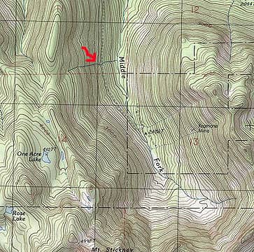 Krom
|
| Back to top |
|
|
Jimbo
Member
Joined: 14 Feb 2005
Posts: 1558 | TRs | Pics
Location: Arlington |
|
Jimbo
Member
|
Thu Jul 16, 2009 8:01 am |
|
|
Good Man H.H. Get er done.. I'll be digging a power line ditch by hand this weekend and having a look at the final close of trails and ? In the Reiter Mess.
Guns only have two enemies; rust and politicians
Guns only have two enemies; rust and politicians
|
| Back to top |
|
|
Scrooge
Famous Grouse

Joined: 16 Dec 2001
Posts: 6966 | TRs | Pics
Location: wishful thinking |
|
Scrooge
Famous Grouse
|
Thu Jul 16, 2009 8:09 am |
|
|
Something lost behind the ranges. Lost and waiting for you....... Go and find it. Go!
|
| Back to top |
|
|
Jimbo
Member
Joined: 14 Feb 2005
Posts: 1558 | TRs | Pics
Location: Arlington |
|
Jimbo
Member
|
Thu Jul 16, 2009 8:32 am |
|
|
Don't feel bad, I've been up and down that road many times and still don't remember a bridge 
Guns only have two enemies; rust and politicians
Guns only have two enemies; rust and politicians
|
| Back to top |
|
|
GeoHiker
Rocky Walker

Joined: 26 Feb 2005
Posts: 6033 | TRs | Pics
Location: Off the Deep End |
|
GeoHiker
Rocky Walker
|
Thu Jul 16, 2009 12:48 pm |
|
|
I haven't been up in that area for about 25 years, so I don't know either. I think HH has it pegged. From the picture it looked to be a decent size gorge. I know from reading TRs that the upper bridge has been gone for years. Maybe that's what they took pics of? I've been wanting to get up that road too, so now that I can get to Olney Pass that's on my short list.
You call some place paradise, kiss it goodbye......Eagles
You call some place paradise, kiss it goodbye......Eagles
|
| Back to top |
|
|
|
|


 It's been awhile. I don't even remember a bridge back along that stretch, which could explain why the pics didn't ring a bell. ...... Only thing I remember back there is a couple of waterfalls
  coming off the cliff and disappearing into the talus. No obvious road crossing point at all.
There's a bridge over the South Fork of the South Fork that really could be a problem, if it were blown out; and of course the bridge at the end of the road, over the Middle Fork, that's been gone for ages.
Have a good recon.
coming off the cliff and disappearing into the talus. No obvious road crossing point at all.
There's a bridge over the South Fork of the South Fork that really could be a problem, if it were blown out; and of course the bridge at the end of the road, over the Middle Fork, that's been gone for ages.
Have a good recon. 