| Previous :: Next Topic |
| Author |
Message |
GeoTom
Member


Joined: 19 May 2005
Posts: 3215 | TRs | Pics
Location: Earth |
|
GeoTom
Member
|
 Mon Jul 20, 2009 9:05 am |
|
|
Trip overview:
Survivors: GeoTom, Chip (neighbor of GeoTom), Terry (friend of neighbor of GeoTom)
Maps: Green Trails #143 Monte Cristo and a TOPO! creation
Access: Highway 2 > Barclay Creek Road (FS Road 6024)
Trails/Route: Head past the port-a-potty at the Barclay Lake trailhead until you see the steep brushy route heading up to the right. Take it to the ridge crest or until you have a heart attack and die.
Mileage: ~6 round trip
Elevation Gain: ~4,400 with the ups and downs
Trip Details:
It only took 5 years since we moved into our house to actually go on a hike with my neighbor Chip (longtime lurker here but not registered yet). After this trip it might be another 5 years before he agrees to go with me again.  Both of us had admired Mt. Baring from the Highway 2 on numerous occasions, and finally decided to try and get to the top. Chip invited his friend Terry along, who had been up Mt. Baring ~25 years ago and swore never to come back. Apparently time heals all wounds.
There have been enough TR's on Baring describing the route, so I don't need to add much other than to say it wasn't as brushy as I expected going up, but it was as steep as advertised. It was even steeper on the way down. The walk along the ridge crest was quite pleasant. The gully still had a few snow patches with the transitions to/from rock getting quite thin. No snow encountered above the notch between the summit and south summit.
We were caught at the summit by 2 other hikers who had witnessed a group of 6 base jumpers doing their thing. The jump spot is a bit below the actual summit. Another group of 3 hikers arrived at the summit a while later, and one of them recognized Soapy from my previous TR's. It was Man-inna-hilz and a couple of his friends. This is the second time in the last month that I have been recognized because of my small green hiking partner (raising2hikers on Dragontail).
Eventually we decided to descend. We survived the descent, but there was a little slipping and sliding and landing on butts.
We arrived at Chip's house safely, but I still had another 50 feet with minimal elevation gain to go. Dani had made cookies (yum!) and Jasper was excited to see me again.
Some photos:
Both of us had admired Mt. Baring from the Highway 2 on numerous occasions, and finally decided to try and get to the top. Chip invited his friend Terry along, who had been up Mt. Baring ~25 years ago and swore never to come back. Apparently time heals all wounds.
There have been enough TR's on Baring describing the route, so I don't need to add much other than to say it wasn't as brushy as I expected going up, but it was as steep as advertised. It was even steeper on the way down. The walk along the ridge crest was quite pleasant. The gully still had a few snow patches with the transitions to/from rock getting quite thin. No snow encountered above the notch between the summit and south summit.
We were caught at the summit by 2 other hikers who had witnessed a group of 6 base jumpers doing their thing. The jump spot is a bit below the actual summit. Another group of 3 hikers arrived at the summit a while later, and one of them recognized Soapy from my previous TR's. It was Man-inna-hilz and a couple of his friends. This is the second time in the last month that I have been recognized because of my small green hiking partner (raising2hikers on Dragontail).
Eventually we decided to descend. We survived the descent, but there was a little slipping and sliding and landing on butts.
We arrived at Chip's house safely, but I still had another 50 feet with minimal elevation gain to go. Dani had made cookies (yum!) and Jasper was excited to see me again.
Some photos:
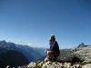
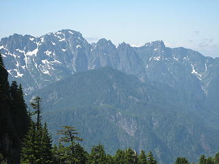
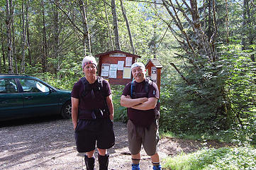 Terry and Chip at the trailhead 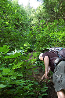 Start of the steepness 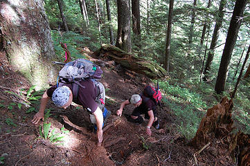 It's a bit steep 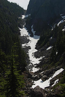 The gully 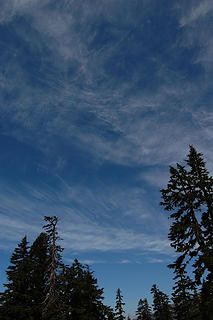 Clouds 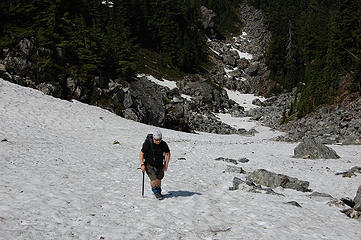 Chip heading up the gully 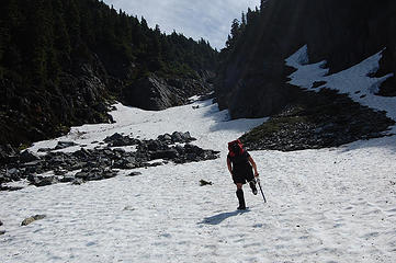 Terry leads the way 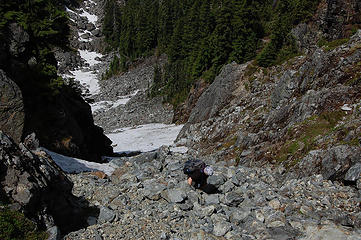 Above the snow patches 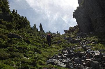 Terry almost to the notch 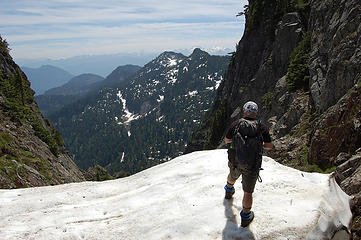 Don't jump! 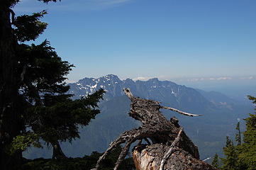 Index and Persis 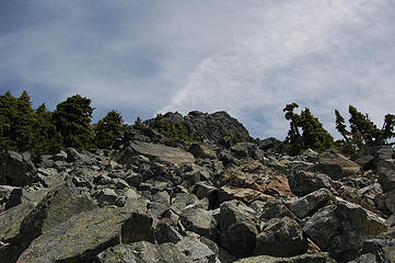 Summit block 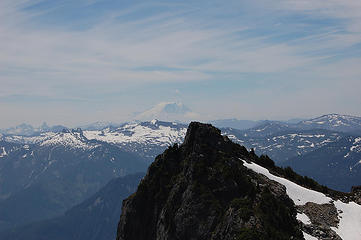 Tahoma over the south summit 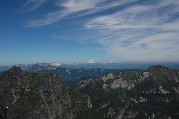 A look north from the summit 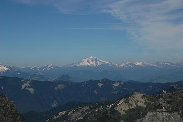 Glacier Peak 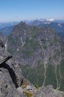 Merchant Peak 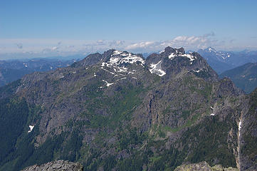 Gunn Peak 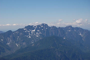 Index and Persis with Philadelphia in front 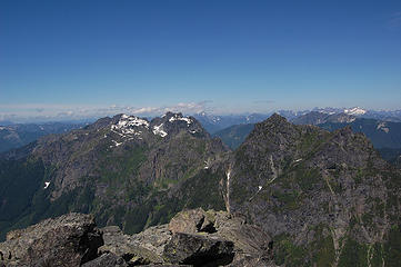 Gunn and Merchant Peaks 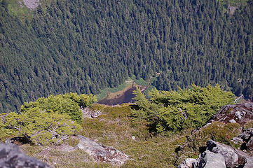 A bit of Barclay Lake way down below 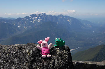 Soapy meets Piglet 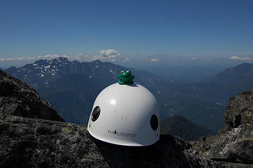 Soapy becoming safety conscious 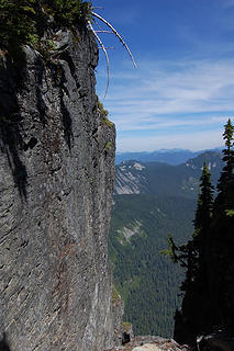 Steep side 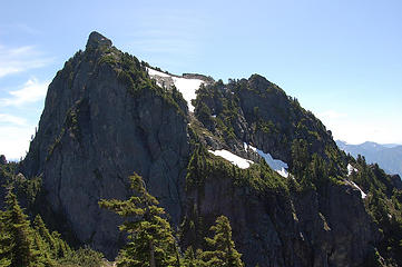 The south summit of Baring 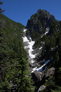 The gully in a better light 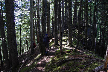 A walk in the woods
|
| Back to top |
  
|
|
Tazz
Member

Joined: 27 Apr 2005
Posts: 7902 | TRs | Pics
|
|
Tazz
Member
|
Mon Jul 20, 2009 9:15 am |
|
|
| Quote: | | it was as steep as advertised. It was even steeper on the way down. |
Wow the grade changes after you reach the top!?! Is there a button to push to make it less steep on the way down?  looks like the nasty steep snow headwall has melted...GOOODBYE SNOW!!!
|
| Back to top |
|
|
wildernessed
viewbagger

Joined: 31 Oct 2004
Posts: 9275 | TRs | Pics
Location: Wenatchee |
Wow, that's a little overbaring of a TR. 
Living in the Anthropocene
Living in the Anthropocene
|
| Back to top |
|
|
Schmidt Altitude
Whippet Entourage

Joined: 28 Mar 2007
Posts: 803 | TRs | Pics
Location: The Quah |
Still jealous about not going on this one. Way to go Soapy entourage!
"Forest 101: These big wood stick things are called trees. The big rocks are called mountains, and the little rocks are their babies." Elliott from Open Season
"Forest 101: These big wood stick things are called trees. The big rocks are called mountains, and the little rocks are their babies." Elliott from Open Season
|
| Back to top |
|
|
Ingunn
Hiking Viking
Joined: 01 Feb 2008
Posts: 1751 | TRs | Pics
Location: Redmond |
|
Ingunn
Hiking Viking
|
Mon Jul 20, 2009 8:43 pm |
|
|
I'm starting to think that the view of Baring from the highway is good enough for me.  Good job, GeoTom and lurkers!
|
| Back to top |
|
|
Mtn Dog
Technohiker

Joined: 01 Aug 2004
Posts: 3336 | TRs | Pics
Location: Bellevue, WA |
|
Mtn Dog
Technohiker
|
Mon Jul 20, 2009 8:44 pm |
|
|
GeoTom:
My brother hiked in to Barclay Lake on Saturday with his family (wife, 7 month old, & 3 YO) along with friends and they said they saw BASE jumpers skydiving off of Baring Mtn also. One landed on the sandy shore of the lake right in front of them. Who knew? That's taking the fast way down for sure!
Footprints on the sands of time will never be made sitting down.
Footprints on the sands of time will never be made sitting down.
|
| Back to top |
|
|
GeoTom
Member
Joined: 19 May 2005
Posts: 3215 | TRs | Pics
Location: Earth |
|
GeoTom
Member
|
Mon Jul 20, 2009 8:55 pm |
|
|
Mtn Dog: We did see lots of kids with their adults back at the trailhead. Some had a confused look as we stumbled out from the brushy area by the porta potty instead of the nice Barclay Lake trail.
|
| Back to top |
|
|
carppdiem
Man of Bronze

Joined: 20 Jul 2009
Posts: 51 | TRs | Pics
Location: 86th Floor |
|
carppdiem
Man of Bronze
|
Mon Jul 20, 2009 8:57 pm |
|
|
Ok, GeoTom's lurking neighbor finally signed up. Now I just gotta figure out the image posting tricks. Looks like there's plenty of online help for tips...
Hopefully it won't take 5 years until our next outing! 
"And I know it seems easy," said Piglet to himself, "but it isn't everyone who could do it."
"And I know it seems easy," said Piglet to himself, "but it isn't everyone who could do it."
|
| Back to top |
|
|
Man-inna-hillz
Member
Joined: 25 Aug 2005
Posts: 286 | TRs | Pics
Location: Berkeley, CA |
Yeah, what GeoTom said. Colin, Stephanie and the author had a nice trip. 3 hours 11 minutes to the summit, 2 hours 37 minutes down.
All I will add is that, in terms of route tips, I would suggest that when you first hit the climber's trail after finding the small stream, stay to the left (east) of the streambed on the way up, but stay in the forest to the right (or descender's left) of the streamlet on the way down. It's definitely easier to climb and find good footing on the steep trail, but easier to descend with the more forgiving forest duff at your feet.
Saw a few Yew trees on the way up. Never noticed any of those in the S. Fork Skyko corridor, so that was cool.
I must also say that the final descent, coming down that sheer ridge approach, is absolute murder on the quads. It's been three days and I'm still hobbling around looking positively elderly.
 Index broadside 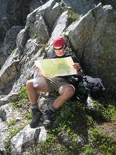 Col lamping with flavor 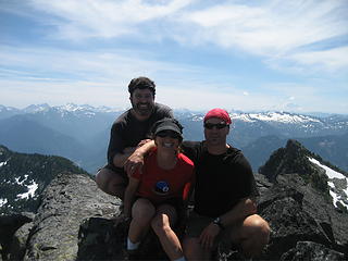 Baring Triumvirate 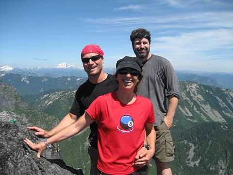 Peter/ Colin/ Steph looking n. from Baring 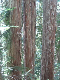 Here's looking at yews 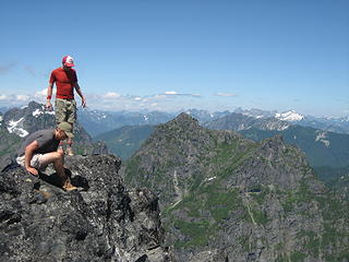 Brian and Kevin on Summit 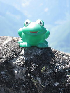 Soapy on Baring Summit
The God of language forgives all crimes.
-W.H. Auden
The God of language forgives all crimes.
-W.H. Auden
|
| Back to top |
|
|
gone
Member
Joined: 08 Feb 2008
Posts: 1051 | TRs | Pics
|
|
gone
Member
|
Mon Jul 20, 2009 9:10 pm |
|
|
| GeoTom wrote: | | Trails/Route: Head past the port-a-potty at the Barclay Lake trailhead until you see the steep brushy route heading up to the right. Take it to the ridge crest or until you have a heart attack and die. |
Way to go, GeoTom and neighborhood hiker gang - killer effort, that really is steep!
Usually steep doesn't really convey via pics, but I'd say those capture it pretty well! 
|
| Back to top |
|
|
Magellan
Brutally Handsome

Joined: 26 Jul 2006
Posts: 13116 | TRs | Pics
Location: Inexorable descent |
|
Magellan
Brutally Handsome
|
Mon Jul 20, 2009 9:11 pm |
|
|
Everybody should do Baring. Then everyone should forget about it as quickly as possible. Nice work team neighbors!
|
| Back to top |
|
|
silence
Member

Joined: 25 Apr 2005
Posts: 4420 | TRs | Pics
|
|
silence
Member
|
Mon Jul 20, 2009 9:43 pm |
|
|
what a grunt ... but it looks like fun anyhow ... hmmm i wonder if one of our friends jumped it this weekend ..
PHOTOS
FILMS
Keep a good head and always carry a light bulb. Bob Dylan
PHOTOS
FILMS
Keep a good head and always carry a light bulb. Bob Dylan
|
| Back to top |
|
|
Yet
Member

Joined: 23 Apr 2005
Posts: 2634 | TRs | Pics
Location: Happily Ever After |
|
Yet
Member
|
Mon Jul 20, 2009 9:50 pm |
|
|
|
| Back to top |
|
|
EastKing
Surfing and Hiking

Joined: 28 Mar 2007
Posts: 2082 | TRs | Pics
Location: 77 miles from Seattle! |
|
EastKing
Surfing and Hiking
|
Tue Jul 21, 2009 11:24 am |
|
|
Great TR and photos. Baring is on my list!!!
YouTube | SummitPost
Saw the depths of despair. Now I am salvaging what time I have left on Earth.
YouTube | SummitPost
Saw the depths of despair. Now I am salvaging what time I have left on Earth.
|
| Back to top |
|
|
Sabahsboy
Member

Joined: 18 Jul 2006
Posts: 2484 | TRs | Pics
Location: SW Sno County |
|
Sabahsboy
Member
|
Tue Jul 21, 2009 11:56 am Baring magnificent
|
|
|
Great TR and photos! All I want is "more...!" Did anyone try the plunge to Barclay (LOL!)? Hoping someone starts IDs of peaks to north and south....I think I spotted Three Fingers in one shot. How about a shot of Paradise Meadows and Mount Townsend? Daniel? Ah...so many peaks so few moments to contemplate! Bravo and Kudos to all for this treasured adventure (my envy to place feet on Baring summit...alas, I was basking on Boardman Lake beach whilst you all struggled to descend on Saturday afternoon).
p.s., Chip, send more photos! Love the link performance of this thread, sent via our office staff!
|
| Back to top |
|
|
|
|


 GeoTom, your TRs make me giggle. But don't let it get to your head. All your other posts are still lame.
