| Previous :: Next Topic |
| Author |
Message |
Mtn Dog
Technohiker


Joined: 01 Aug 2004
Posts: 3336 | TRs | Pics
Location: Bellevue, WA |
|
Mtn Dog
Technohiker
|
 Tue Aug 11, 2009 9:18 pm |
|
|
LEG PWR got four climbing passes for 8/10 back in April. So ten days ago we're trying to reach Preacher Mtn above Rainy Lake in some serious heat and he asks me if I'd be interested in hiking to the rim of Mt Saint Helens with him. Without a 2nd thought I'm like, Yeah! He wanted his son to see the crater before returning to school and he brought along a friend to complete our party of four.
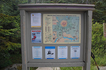
We left Burien at 5:00 AM and on I-5 through Chehalis we are staring at the NW's newest volcano in the early morning light of the southeast sky. There's not a cloud anywhere except toward the coast. We register in Cougar, WA and head to the TH. The roads are paved, well marked, and in really good shape. We're hiking by 9:00 AM starting at 3,750'. The trail is wide and flat with few obstacles as it meanders through forest climbing two miles and up 1,050' to the timberline. We cross the Loowit Trail, which would circumnavigate the mtn if it weren't for the blown out portion at the Toutle River. Then the trail opens up to the flanks of the sleeping giant. By now it's clouded over but we can still see across the south horizon. The trail goes through talus and then follows the rib of Monitor Ridge, all the way to the summit. We work from one side of the ridge to the top of the ridge itself and back while the trail goes from talus, to ashy sand and scree, then back to talus. The talus is Class 3 steep in places. We eventually reach the monitoring station at 6,850'. We can see Mt Hood and Mt Adams in the distance and the nearby slopes are visible around the south flank. But the weather has a cloud layer above us and winds picking up as well. The ascent from here brings us parallel with a chute lined with dirty snow, higher gusting winds of 25 MPH that were steady at times, and blowing clouds that combined with the dust formed light layers of mud on our windward side.
The final ascent requires more breath due to the lighter air and steps placed in loose material would slip a little if you didn't find a good hold. We eventually reach the rim at 8,250' and realize it's only 12:30 PM, we flew! We passed multiple parties on the way up, some of which would never reach the summit. We traversed the rim toward the true summit and could see into the crater some but views were largely restricted by the cloud layer. A few photos, a quick snack, some water, and soon we're dropping back down to where the wind wasn't quite as foreboding. We dropped the first 1,200' in 20 minutes by plunge-stepping the loose scree. We ate lunch above the monitoring station below the windy section. We work our way back to the forest eventually following the poles that line the ridge and mark the gateway to the trail below. For this hike, it works best to stay on rock as much as possible going up, and walk in the scree/sand on the way down. Gaiters help keep loose material from getting into your shoes but aren't an absolute necessity.
The sun joins us for the last half of the hike down and we can see expansive views across the south horizon. We return to the car by 4:30 PM and after signing the register again in Cougar, return home. We're back in Burien at 8:00 PM with the memories of a challenging and really rewarding dayhike that will forever be etched in our memories.
My GPSr showed 8.3 miles RT gaining 4,500' to the rim. Permits are required above Timberline and are self registered from November to March, where the winter ascent route is utilized (next valley to the east). The monitoring station is actually a permanent GPS station that is constantly monitoring its position at a very high degree of accuracy. Stations like this all over the world help geologists study plate tectonics and seismic activity to see how earth's surface is constantly changing. At the summit there was a slight odor of sulphur, just enough to notice in the wind.
Also, I saw a family hiking with a couple younger girls who were real troopers given the trail and conditions. They made quite a day of it together. I also saw one kid hiking in denim shorts, an acrylic jacket, and half tied tennis shoes - that was it. I'm not sure he even had water but the adult he was with, who also hiked in jeans, had a small pack with him. I was relieved to not see any dogs, and not all 100 permitees were on the mountain Monday either. I don't think we saw 60 people all day.
 Trailhead 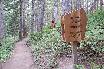 Forested trail, NVM - GPNF 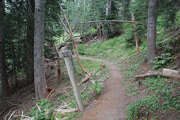 Loowit Trail junction 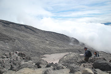 The winter ascent route 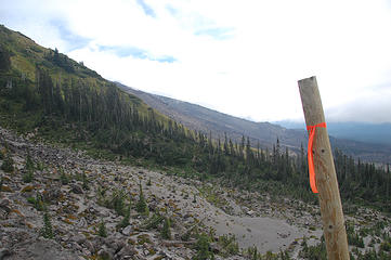 Leaving Timberline 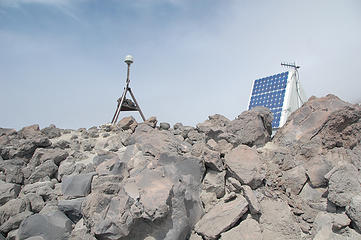 Putting the Monitor in Monitor Ridge 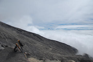 Mt Adams from the ascent 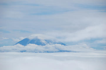 Mt Adams closeup 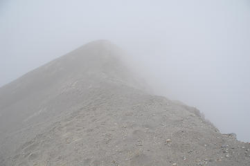 The view from the crater rim 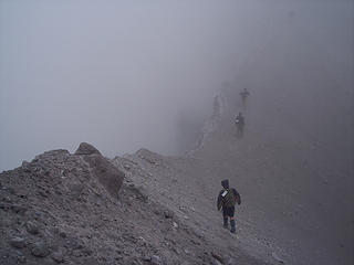 Traversing the summit 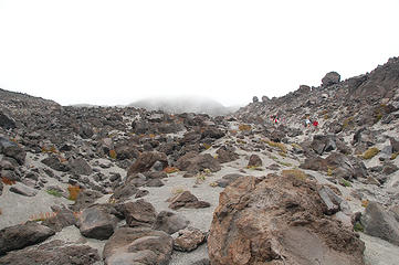 Terrain 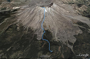 GPS track in 3D
Footprints on the sands of time will never be made sitting down.
Footprints on the sands of time will never be made sitting down.
|
| Back to top |
  
|
|
The Angry Hiker
SAR Blacklistee

Joined: 13 Jun 2008
Posts: 2890 | TRs | Pics
Location: Kentwila |
|
The Angry Hiker
SAR Blacklistee
|
Wed Aug 12, 2009 8:44 am Re: Mt Saint Helens, Monitor Ridge Trail 8-10-2009
|
|
|
| Mtn Dog wrote: | | We passed multiple parties on the way up, some of which would never reach the summit. |
The summit blew off in 1980, and is now scattered across the entire state. So in a sense, they did reach the summit!
I can't imagine climbing that mountain without snow on it. It's three steps up, two steps back in that ash and sand. Good job sticking to it. At least you got some great views of the crater for your effort! 
|
| Back to top |
|
|
yukon222
Member

Joined: 12 Mar 2007
Posts: 1893 | TRs | Pics
|
|
yukon222
Member
|
Wed Aug 12, 2009 9:21 am |
|
|
Nice TR and pics! Too bad you couldn't see into the crater and see the lava dome. Last time I was up there, large chunks of it were continually breaking off.
Amazing scenery up there; I hope everyone gets a chance to see it first hand.
|
| Back to top |
|
|
Magellan
Brutally Handsome

Joined: 26 Jul 2006
Posts: 13116 | TRs | Pics
Location: Inexorable descent |
|
Magellan
Brutally Handsome
|
Wed Aug 12, 2009 9:22 am |
|
|
~4 hours to summit is moving, especially in that scree. God bless those who climb volcanoes without snow.
|
| Back to top |
|
|
Mtn Dog
Technohiker
Joined: 01 Aug 2004
Posts: 3336 | TRs | Pics
Location: Bellevue, WA |
|
Mtn Dog
Technohiker
|
Wed Aug 12, 2009 11:54 am |
|
|
Angry Hiker: The best way to ascend on the scree/sand was to step in a previous footprint. There was usually enough support to not move much and make the most of each step up. Trekking poles helped.
Yukon: While we were on the rim we heard a major rockfall coming from the west side of the crater near the true summit. The sound just went on and on; eerie almost...
Magellan: There were blue diamonds tacked to the trees about 15' up to mark the trail during winter. Under the right conditions climbing on snow would be preferrable, especially if you could ski down! But I think you miss some of the elements that make the volcano experience complete, especially the "otherworldly" terrain. What I found interesting was how much smaller the rock became the further up the slope you climbed. A perfect example of gravity at work.
Footprints on the sands of time will never be made sitting down.
Footprints on the sands of time will never be made sitting down.
|
| Back to top |
|
|
LEG PWR
Member

Joined: 24 Sep 2006
Posts: 13 | TRs | Pics
Location: South Sound |
|
LEG PWR
Member
|
Wed Aug 12, 2009 6:51 pm |
|
|
In the winter you would miss out on all the "fun" of route-finding! See the two gravelly trails on the right slope of the ridge from this shot looking back down? OK, it was a trick question. There are far more than just two.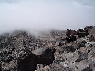 Monitor Ridge trail(s)
|
| Back to top |
|
|
Slow Hiker
Member

Joined: 01 Jun 2008
Posts: 370 | TRs | Pics
|
As you get to the upper half of the beach, it appeared that there was a left and a right route. The right proved to have better footing, as the left was where everyone plunged stepped down. Guess which way I took on the way up 
|
| Back to top |
|
|
|
|
You cannot post new topics in this forum
You cannot reply to topics in this forum
You cannot edit your posts in this forum
You cannot delete your posts in this forum
You cannot vote in polls in this forum
|
Disclosure: As an Amazon Associate NWHikers.net earns from qualifying purchases when you use our link(s). |


