| Previous :: Next Topic |
| Author |
Message |
ethorson
Member


Joined: 07 Jun 2007
Posts: 114 | TRs | Pics
Location: Port Townsend |
|
ethorson
Member
|
 Wed Aug 12, 2009 1:50 pm |
|
|
| silence wrote: | | it's really hard to follow you guys .. even with a topo in front of me since nothing is named .. i mean on the back side .. but anyhow just looking at it with AA's pix .. YIKES!! |
Here is a link to a tiff of the 7.5' topo that shows point 5451:
Chimney Peak Quad
Here is a link to a bunch of quads in Washington:
Washington Quads
|
| Back to top |
  
|
|
silence
Member

Joined: 25 Apr 2005
Posts: 4420 | TRs | Pics
|
|
silence
Member
|
Thu Aug 13, 2009 7:05 am |
|
|
thx for the maps link eric .. wow .. you're an animal .. i don't know how you do it ... i mean the legs and energy for these xc explorations ...
PHOTOS
FILMS
Keep a good head and always carry a light bulb. Bob Dylan
PHOTOS
FILMS
Keep a good head and always carry a light bulb. Bob Dylan
|
| Back to top |
|
|
ethorson
Member
Joined: 07 Jun 2007
Posts: 114 | TRs | Pics
Location: Port Townsend |
|
ethorson
Member
|
Thu Aug 13, 2009 9:01 am |
|
|
I was fiddling around with Google Earth and captured this view of the Godkin/Buckinghorse ridge. I seems to be just as I remembered, with the steep area north of point 5451 evident.
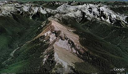 GE-Godkin-Buckinghorse
|
| Back to top |
|
|
boomheist
Member

Joined: 25 Jul 2009
Posts: 55 | TRs | Pics
Location: tacoma |
|
boomheist
Member
|
Thu Aug 13, 2009 2:45 pm Godkin Buckjinghorse
|
|
|
These are great photos and great discussion. I know that the saddle between Muncaster Basin and the bowls below June 10 and Taylor is an easy walk, it just gets gnarly climbing onto Taylor. When we managed to be real stupid and have to work around the west side of the peaks between June 10 and Pyrites Creek, we had hours and hours to stare across the Godkin valley and observe that Buckinghorse Godkin ridge. It has cliffs and looks pretty severe. I wouldn't want to try that route. You guys have convinced me that the proper route to Pyrites is the cold just north of June 10 and then a long long sidehill to the northeast around the head of the Pyrites basin. I'm still hoping to hear from someone who can confirm they have done the Taylor traverse and the route they took. Otherwise next year I'll have to go in from the Low Divide side, or the Pyrites side the correct way, and spend a week back in there finding the route. I'm hoping someone will save me the trouble....
|
| Back to top |
|
|
JustJoe
Member
Joined: 09 Apr 2006
Posts: 32 | TRs | Pics
|
|
JustJoe
Member
|
Thu Aug 13, 2009 4:57 pm |
|
|
Your TR made my day boomheist. Muncaster basin is definitely one of my personal happy places in this world. And way to persevere in the face of challenging conditions and finicky weather.
I've been up in that area solo a few times and I can attest to the ruggedness and beauty of it all. I attempted ascending via Pyrites creek twice, being turned back each time upon reaching the headwaters and being unable to locate a route through those steep thickets to access the pass. And descending that route can be trickier than ascending. I finally discovered the Fire creek route, but my first trip up put me on that very same knife edge ridge it sounds like you were on, which is sketchy to say the least. I made it across and into the upper basin but I will not go that route again. Dropping down into Fire creek drainage at about 3500' is definitely the way to go, even though it's a steep drop initially off the ridge, once into the upper drainage the game trails make it easy going.
I'm planning on getting back up there sometime in mid/late Sep and would be open to considering a possible group assault on the Muncaster/Low Divide route. Given the knowledge of the route of those of us responding to this TR, I think we would have a good shot of completing it. Say 5-7 days, assuming decent weather of course. Shoot me a PM if anyone is interested and we can discuss particulars.
|
| Back to top |
|
|
reststep
Member
Joined: 17 Dec 2001
Posts: 4757 | TRs | Pics
|
|
reststep
Member
|
Thu Aug 13, 2009 5:11 pm |
|
|
boomheist, you could try sending a PM to Larry. Chances are he has been through there.
"The mountains are calling and I must go." - John Muir
"The mountains are calling and I must go." - John Muir
|
| Back to top |
|
|
Dansjolseth
Member
Joined: 15 Jun 2008
Posts: 70 | TRs | Pics
|
|
Dansjolseth
Member
|
Sat Aug 15, 2009 5:59 pm Muncaster Basin Loop
|
|
|
We did that trip plus climb Mount Lawson in about 1983. It is definitely beautiful country -- except the brush in the lower 1000 feet of Pyrites Creek. We went down the east side and wondered if the west side was better. But I will never return to find out.
|
| Back to top |
|
|
Sabahsboy
Member

Joined: 18 Jul 2006
Posts: 2484 | TRs | Pics
Location: SW Sno County |
no 2 cents more from me...I just wished I could have been there! For decades I wondered about that "loop". Exciting TR and, well, bruises and scratches....all worth it? Looks like it! Thanks for the great photo show!
|
| Back to top |
|
|
puzzlr
Mid Fork Rocks

Joined: 13 Feb 2007
Posts: 7220 | TRs | Pics
Location: Stuck in the middle |
|
puzzlr
Mid Fork Rocks
|
Sun Aug 16, 2009 12:15 am |
|
|
It's inspiring how you kept going with day after day of tough bushwhacking. Can't say I wish I was there, but I did enjoy following along on my map.
|
| Back to top |
|
|
goats gone wild
Mr. Goat

Joined: 19 Aug 2007
Posts: 2524 | TRs | Pics
Location: Vampireville |
Very interesting TR, boom. Sounds like you encountered some pretty rough travel but had a great time.  Do you happen to know the time period when the Rustler Creek trail was used/abandoned?
Also, where exactly did the old Pyrites trail connect to? Was it just meant as a passage from the Quinault to the Elwha drainages or did it actually connect with Muncaster Basin at one time?
Several years ago we went up to Martins Park and could see a very distinct trail headed over the saddle towards Muncaster. Was cloudy/foggy/windy and time constraints prevented further exploration--but it was indeed a distinct trail.
Do you happen to know the time period when the Rustler Creek trail was used/abandoned?
Also, where exactly did the old Pyrites trail connect to? Was it just meant as a passage from the Quinault to the Elwha drainages or did it actually connect with Muncaster Basin at one time?
Several years ago we went up to Martins Park and could see a very distinct trail headed over the saddle towards Muncaster. Was cloudy/foggy/windy and time constraints prevented further exploration--but it was indeed a distinct trail.
.....leaving me wanting to return over and over in what ever capacity that may be, even if one day my knees are too old and I can only see the mountains from my porch.
Jason Hummel
.....leaving me wanting to return over and over in what ever capacity that may be, even if one day my knees are too old and I can only see the mountains from my porch.
Jason Hummel
|
| Back to top |
|
|
Larry
Member

Joined: 22 Feb 2003
Posts: 1084 | TRs | Pics
Location: Kitsap |
|
Larry
Member
|
Sun Aug 16, 2009 10:44 pm |
|
|
Got your PM boomeheist. I have attached my memory of the route. I think I have it nailed pretty close, as I still have my drawings and notes after all this time.
The gully route is insane, and foolish that I even did it. The "over the summit" route goes, but I wouldn't do it alone again. Some of the stuff looks awful, only to actually go pretty well once you are committed. I think the "over the summits" route is the most expedient, and probably better than even the full drop to and gain in Rustler basin.
The bivy on the minor summit was phenomenal, and I remember the Northern Lights and some flashlights gleaming down in Chicago Camp about 2 air miles and 4000+ feet below.
Had the Trapper Nelson pack and some decent boots, and that was enough for me.  I marked up the attached image; remember that some of this is from memory a long time ago. Also remember I was a teenager and had a rather typical weird teenager's mindset.
  I do know a couple things though - Rewarding and Magnificent.
Hope this helps.
Larry
I do know a couple things though - Rewarding and Magnificent.
Hope this helps.
Larry
|
| Back to top |
|
|
Dayhike Mike
Bad MFKer
Joined: 02 Mar 2003
Posts: 10958 | TRs | Pics
Location: Going to Tukwila |
Thanks for the beta, Larry!
If I ever get around to making this traverse, I'll definitely post pics and details of the trip.
"There is only one basic human right, the right to do as you damn well please. And with it comes the only basic human duty, the duty to take the consequences." -P.J. O'Rourke
"Ignorance is natural. Stupidity takes commitment." -Solomon Short
"There is only one basic human right, the right to do as you damn well please. And with it comes the only basic human duty, the duty to take the consequences." -P.J. O'Rourke
"Ignorance is natural. Stupidity takes commitment." -Solomon Short
|
| Back to top |
|
|
Ancient Ambler
Member

Joined: 15 May 2007
Posts: 1092 | TRs | Pics
Location: Bainbridge Island |
Great route, Larry. Thanks for the very detailed route map and notes on the dicey sections. It is just great to see you post again on nwhikers. As far as I know, it's been a few years since you have. Before I ever started posting here, I got a lot of enjoyment out of your excellent writing on nwhikers. Your lists of Olympic traverses back in 2003 are awe-inspiring. If you've been keeping notes and sketches of some of those traverses, is there any chance of your posting some route maps of those traverses similar to what you just did here with the Taylor traverse? By comparison, the Oly Climber's Guide description of the Taylor route is almost worthless.
|
| Back to top |
|
|
Larry
Member
Joined: 22 Feb 2003
Posts: 1084 | TRs | Pics
Location: Kitsap |
|
Larry
Member
|
Mon Aug 17, 2009 8:50 am |
|
|
| Ancient Ambler wrote: | | Great route, Larry. Thanks for the very detailed route map and notes on the dicey sections. It is just great to see you post again on nwhikers. As far as I know, it's been a few years since you have. Before I ever started posting here, I got a lot of enjoyment out of your excellent writing on nwhikers. Your lists of Olympic traverses back in 2003 are awe-inspiring. If you've been keeping notes and sketches of some of those traverses, is there any chance of your posting some route maps of those traverses similar to what you just did here with the Taylor traverse? By comparison, the Oly Climber's Guide description of the Taylor route is almost worthless. |
Hope you can use the route, glad to give you or anyone else info
on any place I've might have visited.
I've been rewardingly busy wth a huge project over the past
few years, and the extra time to do things has been precious.
Things are finally winding down, and perhaps I'll post a few more
trips that I've done lately.
A nice thing I did last summer was to visit Mount Norton from
Elwha Valley, and then do the ridge to Crystal Peak. It was what
I would call the "Bailey Range Twin Traverse" since the Bailey
Range was always in sight across the valley to the west...haha.
The ridge was long and lonely and wonderful. Probably saw
about 3,124 bears.  Crystal Peak and its lakes - phenomenal, primal, and remote.
To me...a classic.
I'm heading out for 9 days just after Labor Day for another
one of those long traverses that are so fun and rewarding.
I hope I'm not getting too old for all that sweat and gasping.
Crystal Peak and its lakes - phenomenal, primal, and remote.
To me...a classic.
I'm heading out for 9 days just after Labor Day for another
one of those long traverses that are so fun and rewarding.
I hope I'm not getting too old for all that sweat and gasping.  I am gratified that you "got something" out of my old reports.
Good memories.
Here's an image from a wonderfully isolated place in the Olympics. Yeah,
I ran back to the big Mamiya RB67 and hoisted it just as the timed
shutter clicked. Just goes to show I'm still foolish enough to carry
such a huge beast of a camera all over hell. Of course, in the fog, I had
no idea where I was going - like my grandfather used to say, "Are we
coming or going?"
I am gratified that you "got something" out of my old reports.
Good memories.
Here's an image from a wonderfully isolated place in the Olympics. Yeah,
I ran back to the big Mamiya RB67 and hoisted it just as the timed
shutter clicked. Just goes to show I'm still foolish enough to carry
such a huge beast of a camera all over hell. Of course, in the fog, I had
no idea where I was going - like my grandfather used to say, "Are we
coming or going?" 
|
| Back to top |
|
|
Ancient Ambler
Member
Joined: 15 May 2007
Posts: 1092 | TRs | Pics
Location: Bainbridge Island |
Larry,
It's great to hear you'll be heading out into the mountains more and bringing back some reports and photos. That is one huge camera and tripod you're lugging in that photo. Take any photos on your trip into Crystal Lakes last year? Care to share?
|
| Back to top |
|
|
|
|


