| Previous :: Next Topic |
| Author |
Message |
Conrad
Meadow bagger


Joined: 25 Aug 2006
Posts: 2298 | TRs | Pics
Location: Moscow, ID |
|
Conrad
Meadow bagger
|
 Thu Jul 16, 2009 9:39 pm |
|
|
The Idaho/Montana Stateline Trail (we hiked the section from Hoodoo Pass south) is 135 miles E of Coeur d'Alene. It's long and uncrowded, with moderate elevation gain, constant meadows and views (of Rockies ridges, not snowy Cascade crags). It's also dry; we found water at Goose Lake only. We carried 3 quarts per person each day and used it all.
There would be advantages to this trail either early or late season. It melts off early (we found just a few snow patches), and the flowers were great the 2nd week of July. But later, there are miles of blueberries (not yet ripe for us) and the bugs will die down. And there's no water-availability penalty for going late, since Goose Lake appears to be the only (and a good) convenient water source, early or late.
About bugs: There were flies on the crest, just buzzing the 1st day, biting some on the 2nd and 3rd days. There were lots of mosquitoes down at Goose Lake, especially the cloudy 2nd afternoon, but not as bad as the clouds of them we found at Juanita Lake (Chelan Sawtooths) last year.
Trip Summary:
Day 1 (7/10F): Hoodoo Pass S to Goose Lake
Day 2 (7/11Sa): Dayhike further S & return to Goose Lake
Day 3 (7/12Su): Back to Hoodoo Pass
Day 1: Hoodoo Pass S to Goose Lake
My teenage son and I drove from Moscow to Coeur d'Alene, then E/SE on I-90 to Superior, MT, then SW up the Trout Creek road to Hoodoo Pass, 6000'.
We set off SE for Goose Lake. The trail switchbacks up a few hundred feet in forest; then it's mostly meadows between 6500-7500' all the way until the final 1500' drop to Goose Lake (5800') at ~8 miles.
At ~3 m (from Hoodoo) a side trail takes off E to Heart Lake. If you want to take this trail (we didn't), the start is easy to see when hiking N on the Stateline, but when hiking S, it's very hidden; the first few feet are just a rock slab and then it dives behind a big tree. If you're going S and miss it, though, and go 1/4 mile too far and look back N, you can see it switchbacking down the E side of the crest.
At ~5 m another side trail heads NE to Pearl Lake. The junction was under a snowfield when we were there, and both forks (to Pearl Lake, or the Stateline continuing SE) start off in similar directions, so watch your directions here.
Goose Lake isn't even shown on my 1:100000 USGS map, but it's a substantial if muddy/marshy lake. It does have a nice sweet inlet stream, which we couldn't find at first (to find it, round the lake CW from the big meadow, choosing paths closest to the shore), but it tastes much better than the moose-bath outlet stream (our camp neighbors saw the moose but we missed it).
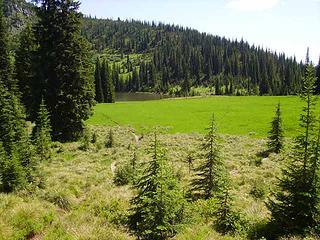 Goose Lake
|
| Back to top |
  
|
|
Alpendave
Member

Joined: 01 Aug 2008
Posts: 863 | TRs | Pics
|
Nice TR of a nice area. Beautiful photos as well. I have yet to get up there since moving to Spokane from Bellingham. Trailjunky has a nice TR from a trip to Siamese Lakes he did last year.
You mentioned no water except Goose Lake. What about the small lake you photographed from the ridge? It looked fairly easy to get down to. Or was it not far enough from Goose Lake to be a practical sourse of refill water?
Dave
|
| Back to top |
|
|
Conrad
Meadow bagger
Joined: 25 Aug 2006
Posts: 2298 | TRs | Pics
Location: Moscow, ID |
|
Conrad
Meadow bagger
|
Fri Jul 17, 2009 7:03 am |
|
|
Those side lakes (including the one in the picture) looked to me like easier scrambles when I reconnoitered in Google Earth, and in my pictures, than they looked in person. I'm sure some people could get to them -- I probably could myself if I had to -- but especially with a less experienced companion along, it seemed to me safer and easier to just carry extra water.
|
| Back to top |
|
|
Lochsa
Member

Joined: 21 Dec 2007
Posts: 31 | TRs | Pics
Location: Spokane |
|
Lochsa
Member
|
Mon Aug 10, 2009 6:04 pm |
|
|
I was up there for a day hike that Sunday. I'd planned to hit Goose Lake but was distracted by a band of goats near Heart Lake, which I spied on for over an hour. Those white devils will get you every time.
There were decent trails down to at least 5 lakes that I saw where one could get water.
|
| Back to top |
|
|
drilldaddyo
Member
Joined: 28 Feb 2008
Posts: 69 | TRs | Pics
Location: Spokane, Washington |
From the Hoodoo Pass parking lot to Goose Lake there is no easy way to obtain water other than snowmelt at the right time of year. The lakes you see from that portion of the Stateline Trail are easily a one hour (or more)round trip depending on your fitness level.
Between Goose Lake and Fish Lake (South of Goose Lake) the State Line Trail is almost just as dry. The above photo of the small lake is the only easy access to water along that portion of the trail.
A very nice loop is to hike into Fish lake, access the State Line Trail, head North to Goose lake, and return to your starting point via the Goose Creek Trail.
|
| Back to top |
|
|
drilldaddyo
Member
Joined: 28 Feb 2008
Posts: 69 | TRs | Pics
Location: Spokane, Washington |
PS: Alpendave.......you owe yourself a trip to this area. It's about 2.5 hours from Spokaloo. Access FS 250 from the Superior, MT exit off of I90.
|
| Back to top |
|
|
Bright River
goslowgofar
Joined: 21 Aug 2007
Posts: 223 | TRs | Pics
Location: above the pogonip |
|
Bright River
goslowgofar
|
Thu Aug 13, 2009 6:33 pm Idaho State Centential Trail
|
|
|
Hoodoo Pass is on the Idaho State Centenial Trail as well as the Stateline trail. The entire trail runs about 1,500 miles as I remember, and there is a guide written by Stephen STuebner and the Idaho Trails Council. There is a good website with topo Maps on the Idaho State Recreational website ( Idaho Dept of Parks and Recreation?). Lot of nice Country out there.
I,ve walked and berry picked pieces of the ridge when my folks were still leaving at the base.
..-and rest thee by many brooks and hearthsides without misgiving. Rise free from care before the dawn and seek adventures. Let the noon find thee by other lakes, and the night overtake thee everywhere at home. HDT
..-and rest thee by many brooks and hearthsides without misgiving. Rise free from care before the dawn and seek adventures. Let the noon find thee by other lakes, and the night overtake thee everywhere at home. HDT
|
| Back to top |
|
|
|
|
You cannot post new topics in this forum
You cannot reply to topics in this forum
You cannot edit your posts in this forum
You cannot delete your posts in this forum
You cannot vote in polls in this forum
|
Disclosure: As an Amazon Associate NWHikers.net earns from qualifying purchases when you use our link(s). |


