| Previous :: Next Topic |
| Author |
Message |
David¹
Token Canadian


Joined: 25 Jul 2002
Posts: 3040 | TRs | Pics
Location: The Great White North |
|
David¹
Token Canadian
|
 Mon Aug 24, 2009 7:56 pm |
|
|
For me taking a good photo is more of a happy accident, however serious photographers know the secret is all in the preparation. I had this photo composition in mind:
| Galiwalker wrote: | 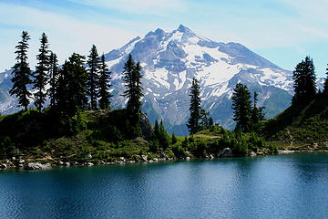 Glacier Peak (10,528ft) and Lake Byrne (5,544ft). Lost Creek Ridge hike, Glacier Peak Wilderness; Aug 11th, 2007. |
Only I wanted to do one better and capture it at sunset. Usually I'm not willing to make the effort but I had no choice since Karen was adamant about never going back to Lake Byrne (she had an unfortunate experience in 2000)
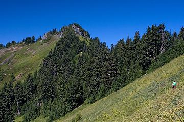
The trail gains something like 3600ft in the first 4.5 miles but it is well graded and was painless thanks to some great company from Kayakbear and a couple of fun dudes we met along the way (their report)
 Blueberry Fields Forever 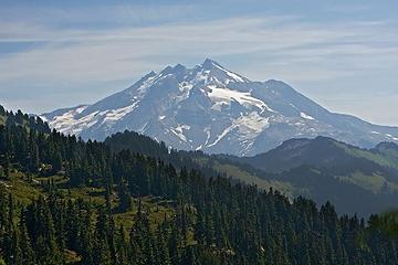 First Sighting of Glacier Peak 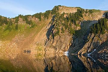 Camp Lake 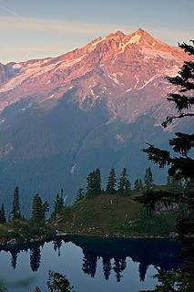 Alpenglow on Glacier Peak 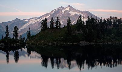 Byrne Lake Sunset 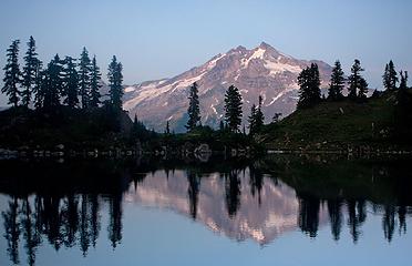 Byrne Lake 
|
| Back to top |
  
|
|
Magellan
Brutally Handsome

Joined: 26 Jul 2006
Posts: 13116 | TRs | Pics
Location: Inexorable descent |
|
Magellan
Brutally Handsome
|
Mon Aug 24, 2009 8:08 pm |
|
|
I have yet to experience the full lenght, but the ups and downs of Lost Creek Ridge have humbled more than one party. Sorry you didn't get what you wanted. Galiwalker is indeed a formidable hiker.  ETA: Byrne Lake was usually accessed from Kennedy Hot Springs via 2200' of steepness, after an easy 5 mile walk to the springs. My guess is the lake may be starting to recover since the blowout in 2003 put a damper on this approach.
|
| Back to top |
|
|
Highwalker's Daughter
Member

Joined: 12 Aug 2006
Posts: 1575 | TRs | Pics
Location: Bothell, WA |
A timely TR for us as we were planning this one for Labor Day weekend. It doesn't sound like many campsites between the trailhead and Camp Lake, and we can't start until about 6 p.m. due to my work schedule so it sounds like we'd better car camp the first night; then plan on all day to reach the destination as we're probably way slower than you are!
Also, "thin, treacherous scar" sounds kind of bad. Is it safe enough for a dumb dog?
Thanks,
Kari
|
| Back to top |
|
|
touron
Member
Joined: 15 Sep 2003
Posts: 10293 | TRs | Pics
Location: Plymouth Rock |
|
touron
Member
|
Mon Aug 24, 2009 8:33 pm |
|
|
Touron is a nougat of Arabic origin made with almonds and honey or sugar, without which it would just not be Christmas in Spain.
|
| Back to top |
|
|
David¹
Token Canadian
Joined: 25 Jul 2002
Posts: 3040 | TRs | Pics
Location: The Great White North |
|
David¹
Token Canadian
|
Mon Aug 24, 2009 8:45 pm |
|
|
| Highwalker's Daughter wrote: | | It doesn't sound like many campsites between the trailhead and Camp Lake, and we can't start until about 6 p.m. due to my work schedule so it sounds like we'd better car camp the first night; then plan on all day to reach the destination as we're probably way slower than you are!
Also, "thin, treacherous scar" sounds kind of bad. Is it safe enough for a dumb dog?
Thanks,
Kari |
There are lots of places to camp - the issue was water. There are a couple of trickles but no reliable water source until Hardtack Lake (unless you count the Round Lake Spur) FWIW the 8.5 mile return hike took only 5hrs
Your dog should be fine, the problem was tired clumsy human feet
|
| Back to top |
|
|
raising3hikers
Member

Joined: 21 Sep 2007
Posts: 2344 | TRs | Pics
Location: Edmonds, Wa |
Those look like some pretty good pics to me
|
| Back to top |
|
|
chiwakum
not credible

Joined: 29 Jun 2009
Posts: 980 | TRs | Pics
Location: Ballard |
|
chiwakum
not credible
|
Mon Aug 24, 2009 9:47 pm |
|
|
there is reliable water coming down into the meadows below sunup lake. you should be able to refill at that point. there are also some decent camping options at that point (and sunup is nice for swimming if you don't mind the resident biting waterbugs). from there the next reliable water might be as far as hardtack.
|
| Back to top |
|
|
GaliWalker
Have camera will use

Joined: 10 Dec 2007
Posts: 4930 | TRs | Pics
Location: Pittsburgh |
|
GaliWalker
Have camera will use
|
Tue Aug 25, 2009 4:23 am |
|
|
 I still remember the last few miles on the return and the interminable ups-and-downs... I still remember the last few miles on the return and the interminable ups-and-downs...
| David¹ wrote: | Byrne Lake |
You might have missed sunset, but this one is really nice. Much better than mine. Now you've got me hankering for a return near sunrise/sunset!
|
| Back to top |
|
|
Foist
Sultan of Sweat

Joined: 08 May 2006
Posts: 3974 | TRs | Pics
Location: Back! |
|
Foist
Sultan of Sweat
|
Tue Aug 25, 2009 6:16 am |
|
|
You still got a few beautiful photos there. That trail is a real bum-kicker, the ups and downs are endless. Why couldn't you camp at Hardtack lake? Kim and I did, it was fine. Was it too far from Byrne so that it would be hard to get back to camp after sunset?
|
| Back to top |
|
|
Foist
Sultan of Sweat
Joined: 08 May 2006
Posts: 3974 | TRs | Pics
Location: Back! |
|
Foist
Sultan of Sweat
|
Tue Aug 25, 2009 6:26 am |
|
|
| Quote: | | Only I wanted to do one better and capture it at sunset. Usually I'm not willing to make the effort but I had no choice since Karen was adamant about never going back to Lake Byrne (she had an unfortunate experience in 2000) |
Ha! I just read her "unfortunate incident." Does she never want to go back so as not to dilute the memory of the place? That is a great engagement spot, probably better than Surprise Mountain (mine, last year). Now it's an even better one because you're much less likely to have other people show up and crash your moment.
|
| Back to top |
|
|
Jim Dockery
Member

Joined: 12 Sep 2007
Posts: 3092 | TRs | Pics
Location: Lake Stevens |
Great story that many of us photo-addicts can relate to. I have often found myself running to get in position for a sunrise/set that I thought I had time to hike to, sometimes I enjoy the intense workout, but not always (esp. at altitude). As I mellow (a bit) with age I try to remember the words of Teddy Roosevelt: "Do what you can, with what you have, where you are." This great adage applies to many aspects of life, in photography it helps me to chill out if I don't make my planned destination on time and look where I am, which sometimes turns out to be serendipitous.
I think you did great with those shots, although I feel for you being rushed and not having the time to set up and enjoy the full range of the sunset.
|
| Back to top |
|
|
Highwalker's Daughter
Member
Joined: 12 Aug 2006
Posts: 1575 | TRs | Pics
Location: Bothell, WA |
Thanks for the info on campsites and water.
|
| Back to top |
|
|
plain old dan
Member

Joined: 24 Aug 2005
Posts: 276 | TRs | Pics
Location: Tualatin Oregon |
That hike kicked my butt to. It's not really the ups and downs on a long ridge walk, it's all that after a strenuous start to the hike with lots of elevation gain just to get up onto the ridge. It's easy to underestimate this one, especially on a hot day.
|
| Back to top |
|
|
Kim Brown
Member
Joined: 13 Jul 2009
Posts: 6899 | TRs | Pics
|
Plain Old Dan because of your great trip report on Lost Creek Ridge, Jonathan Toren and I, were prepared for the ass-kicking that it was.
Its easy to underestimate this trip if youre counting contour lines and calculating elevation gain/loss that way. What we found out once up on the ridge was that the contours of 100 feet on the map (or 90, cant remember which) dont show the +70, -80, +50 changes all embedded within one contour. So you can add 100 for the contour on the map, but theres a whole lot in between!
Lost Creek Ridge is among the best hiking trips I have ever had.
David, Jonathan and I camped at Hardtack Lake. But you did better by continuing on; Jonathan and I had the time to split the trip up a little.
"..living on the east side of the Sierra world be ideal - except for harsher winters and the chance of apocalyptic fires burning the whole area."
Bosterson, NWHiker's marketing expert
"..living on the east side of the Sierra world be ideal - except for harsher winters and the chance of apocalyptic fires burning the whole area."
Bosterson, NWHiker's marketing expert
|
| Back to top |
|
|
David¹
Token Canadian
Joined: 25 Jul 2002
Posts: 3040 | TRs | Pics
Location: The Great White North |
|
David¹
Token Canadian
|
Tue Aug 25, 2009 9:23 am |
|
|
| Quote: | | Finally far below we saw a tarn that we took for Hardtack Lake. |
| Quote: | | Imagine my delight when after 40 minutes of additional hiking I came upon the REAL Camp Lake |
I thought this was obvious but we actually camped at Hardtack. We just didn't know it at the time.
|
| Back to top |
|
|
|
|


 Great pictures and an A+ for effort!