| Previous :: Next Topic |
| Author |
Message |
jeremybe
Ol' One-shirt


Joined: 17 Jul 2008
Posts: 275 | TRs | Pics
Location: Seattle |
|
jeremybe
Ol' One-shirt
|
 Mon Aug 31, 2009 2:11 pm |
|
|
Somehow, I found myself with an extended weekend at the very end of August; Nicole didn't. Thus, the table was set for my Second Annual Solo Backpacking Trip, a trip set to coincide with my twenty-ninth birthday. Certain conditions were to be met. The hike couldn't be too high on our must-do list, because Nicole wouldn't be along to enjoy it. I also wanted something that would challenge me. And why not make something that's a little further away than our normal weekend overnighter?
In the end, I decided on Ice Lakes, via the Entiat River. 100 Hikes... put the round-trip mileage at ~28 and recommended allowing 3-5 days. Ice Lakes were on my list, and the criterion fit. I'd be carrying a heavy backpack (~45lbs) but reasoned that the elevation gain would be spread over so much mileage that it'd be no problem. More training for the Canadian Rockies! My itinerary was flexible: I'd leave Thursday, make the lakes Friday, spend Saturday exploring or summiting Mt. Maude, and return Sunday. Or, if the forecasted thunderstorms came to fruition, I might return Saturday instead. Whatevs.
I left straight from work on Thursday around 12:30, and pulled into the trailhead parking lot at the end of Entiat River Road at 16:00. The drive was nice, taking me past Leavenworth for the first time through Wenatchee and north along the Columbia River through an interesting landscape. Though there were signs warning of big horn sheep crossings, I saw none.
I booted up and hit the trail at 16:20, setting a comfortably quick pace in order to put as many easy miles behind me as possible on the first day. The trail starts off wide and dry, mixed-use as it is (hikers, horses, motorcycles). The trees turn from somewhat unhealthy-looking to fully fire-scarred and destroyed as one makes progress down the Entiat River trail.
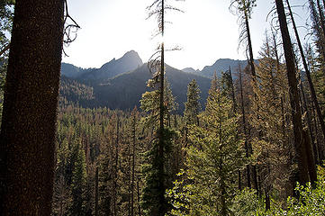 Along the Entiat. 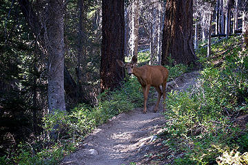 Deer on the Entiat River trail. 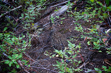 Camouflaged grouse. 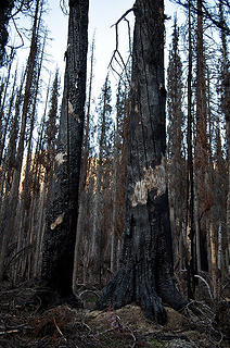 In the burn. 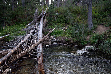 Entiat River crossing. 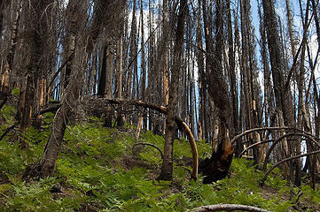 Burn and ferns. 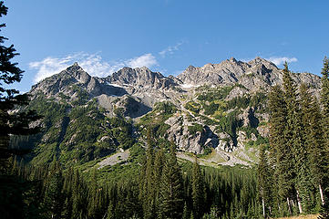 South of the Spectacle Buttes. 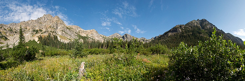 Ice Creek meadow panorama. 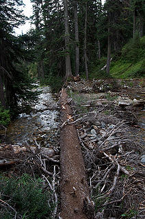 Ice Creek crossing. 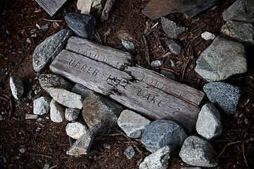 Ominous signage. 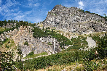 Beginnings of Ice Creek. 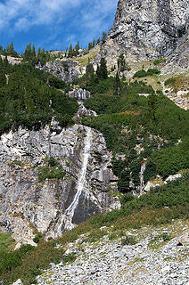 Waterfall en route to Lower Ice Lake. 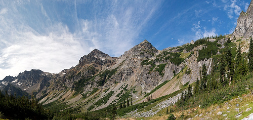 Looking back at Entiat Mountains. 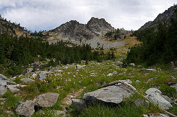 Steeper than it appears. 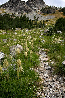 Flowers along the path to Lower Ice Lake. 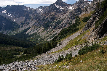 Down Ice Creek valley. 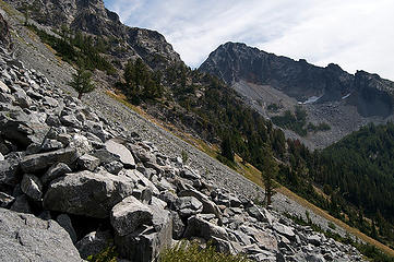 Climbing up to Lower Ice Lake. 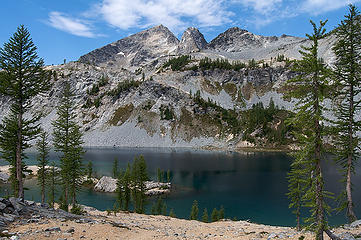 Lower Ice Lake. 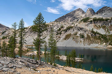 Lower Ice Lake. 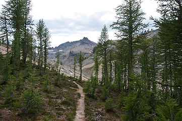 Larch in the Lower Ice Lake area. 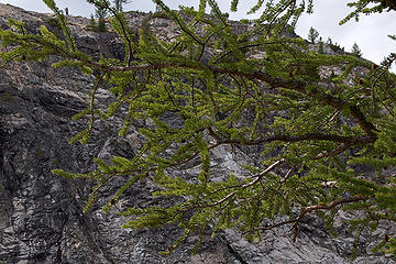 It ain't October yet. 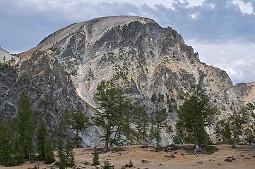 North Spectacle Butte. 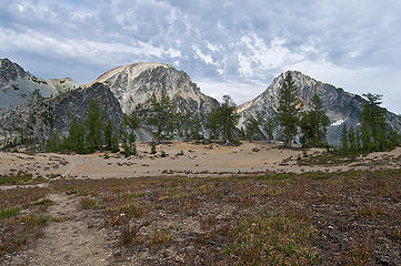 The Spectacle Buttes from Lower Ice Lake. 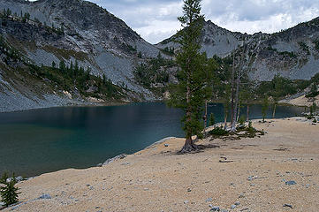 Pumice grounds at Lower Ice Lake. 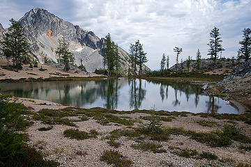 A moment of calm on Lower Ice Lake. 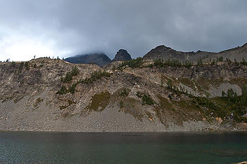 Mt. Maude in clouds in the morning. 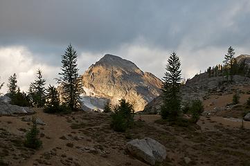 Sunrise on the Entiat Mountains. 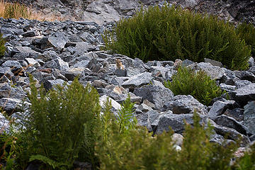 A pika. 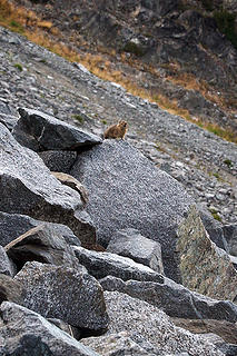 Another pika. 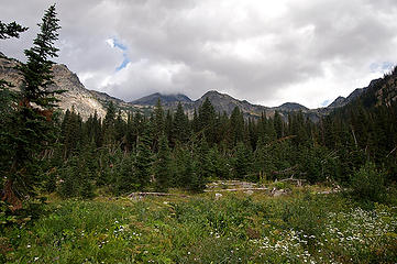 Looking back on my way out.
|
| Back to top |
  
|
|
yukon222
Member

Joined: 12 Mar 2007
Posts: 1893 | TRs | Pics
|
|
yukon222
Member
|
Mon Aug 31, 2009 4:18 pm |
|
|
Fun to read this TR; you tell the story well.  Isn't amazing how those last couple of miles seemed to drag out forever when you are approaching the end of a long hike?
  Upper Ice Lake and Maude are worth a return trip. I enjoyed my visit last year. Still need to get back in there for 7FJ.
|
| Back to top |
|
|
jeremybe
Ol' One-shirt
Joined: 17 Jul 2008
Posts: 275 | TRs | Pics
Location: Seattle |
|
jeremybe
Ol' One-shirt
|
Mon Aug 31, 2009 6:37 pm |
|
|
Thanks, yukon.
I definitely do want to return, from the Phelps Creek side. I loved looking at the perfect ramp up Mt. Maude. I want to make it back and summit!
|
| Back to top |
|
|
yukon222
Member
Joined: 12 Mar 2007
Posts: 1893 | TRs | Pics
|
|
yukon222
Member
|
Mon Aug 31, 2009 7:19 pm |
|
|
Next time I go back in there, I'd like to camp in the upper reaches of Leroy Basin. 7FJ and perhaps another.
Lots of scenery in there; the larches last fall were incredible. Camping at Upper Ice Lake was quite chilly but worth it for a crisp fall day.
|
| Back to top |
|
|
gone
Member

Joined: 08 Feb 2008
Posts: 1051 | TRs | Pics
|
|
gone
Member
|
Mon Aug 31, 2009 8:28 pm |
|
|
Wonderful report, spectacular pictures - those looks back down the Ice Creek valley are just stunning. Well done! 
|
| Back to top |
|
|
Sabahsboy
Member

Joined: 18 Jul 2006
Posts: 2484 | TRs | Pics
Location: SW Sno County |
jeremybe, thank you! I have no idea where my old photos are of this trip you described. I went in around October 15, probably in early 1980s. Camped at that crossing and day hiked to Lower (then Upper) Ice Lakes( and Entiat headwater cirque). It was gorgeous though the larch were near finished at Ice Lakes. A cold wind came and snow began to flurry so I hopped along the trail back to base camp....and, later, got snowed in! Next morning had to somehow fold and mutilate camping gear to get the frozen stuff into bag and head out. A number of hunters were exiting, too. It was my third trip in that area that year....I had gone up to cirque of Seven Fingered Jack and Maud/etc. and loved it. The base camp described above afforded trip to cirque in August and that October, too! The larch "gold" was good in the cirque....and the bad black flies gone in October. Your TR brings back wonderful memories (however, Snoqualmie Pass closed and I had a heck of a time getting back from Wenatchee to Seattle and work....when the Pass re-opened, dozens of trucks were jack-knifed, etc. Absolutely the worst snow driving I ever encountered except the "blizzard" of November, 1985 right here in Seattle (oh, and I confess, driving friend's car in Norway during change of season snowstorm, sliding over passes as national roads folks closed roads following our passage...we did manage to return to Oslo in one piece).
|
| Back to top |
|
|
the Zachster
Member

Joined: 17 Jan 2007
Posts: 4776 | TRs | Pics
Location: dog training |
Great trip report! We went in that way also and swore that next time we would hire some pack animals to haul our stuff at least as far as the creek!  It is so beautiful up there...glad you got to enjoy it a bit. Your picture of "a moment of calm" is absolutely gorgeous. It's an amazing place to have all to yourself! It is so beautiful up there...glad you got to enjoy it a bit. Your picture of "a moment of calm" is absolutely gorgeous. It's an amazing place to have all to yourself!
"May I always be the kind of person my dog thinks I am"
"May I always be the kind of person my dog thinks I am"
|
| Back to top |
|
|
jeremybe
Ol' One-shirt
Joined: 17 Jul 2008
Posts: 275 | TRs | Pics
Location: Seattle |
|
jeremybe
Ol' One-shirt
|
Tue Sep 01, 2009 6:51 am |
|
|
Thanks, all.  @ Sabahsboy: Wow, that's some weather, and driving. Glad the report stirred something for you.
|
| Back to top |
|
|
Sabahsboy
Member
Joined: 18 Jul 2006
Posts: 2484 | TRs | Pics
Location: SW Sno County |
Your report did stir and I thank you for that! Your photos are terrific!
|
| Back to top |
|
|
Bedivere
Why Do Witches Burn?

Joined: 25 Jul 2008
Posts: 7464 | TRs | Pics
Location: The Hermitage |
|
Bedivere
Why Do Witches Burn?
|
Wed Sep 02, 2009 5:28 pm |
|
|
Great report! That's a long hump out in one day. Last time we did it we stayed along the Entiat trail to break it up some. There are a lot of really nice camp spots along the Entiat.
Definitely go back and bag Maude and upper Ice Lake. The trek up to Leroy Basin is fairly arduous and just a warm-up for what's to come beyond that point. Best to break it up into 2 days if you can.
I want to hit Leroy Basin and bag 7FJ in early October, weather permitting. Want to come along?
|
| Back to top |
|
|
jeremybe
Ol' One-shirt
Joined: 17 Jul 2008
Posts: 275 | TRs | Pics
Location: Seattle |
|
jeremybe
Ol' One-shirt
|
Thu Sep 03, 2009 8:19 am |
|
|
Thanks, Chainsaw.
Keep me posted on your 7FJ trip; I'm interested, depending on the details. I didn't know that 7FJ was a walk-up as well. I've yet to make it over 8000', so topping 9000' would be pretty excellent.
Plus: larches then.
|
| Back to top |
|
|
Slugman
Its a Slugfest!

Joined: 27 Mar 2003
Posts: 16874 | TRs | Pics
|
|
Slugman
Its a Slugfest!
|
Thu Sep 03, 2009 8:38 am |
|
|
I've always figured the only way I could do that trip in three days was to use a mtn bike for the first/last 4 miles. How would the trail be for riding, do you think? Even if I had to just push the bike on the way in, the four mile glide on the way out would justify it (I think, not having been there).
|
| Back to top |
|
|
Conrad
Meadow bagger

Joined: 25 Aug 2006
Posts: 2298 | TRs | Pics
Location: Moscow, ID |
|
Conrad
Meadow bagger
|
Thu Sep 03, 2009 9:12 am |
|
|
| Slugman wrote: | | How would the trail be for riding, do you think? |
Should be great (as I remember from hiking it a couple of years ago).
It's pretty flat. You'd probably be pedaling both ways, rather than pushing/gliding.
|
| Back to top |
|
|
jeremybe
Ol' One-shirt
Joined: 17 Jul 2008
Posts: 275 | TRs | Pics
Location: Seattle |
|
jeremybe
Ol' One-shirt
|
Thu Sep 03, 2009 9:58 am |
|
|
I'd also think it'd be fine for biking. That portion of the trail has zero rocks, some tree roots, but little else. If anything, it's dry and sandy in portions and therefore almost like a beach. But most of it just just dry hardpack, or is at this time of the year.
As for ups and downs...it's very gradual uphill on the way in, and the reverse on the way out. Though there are a few spots where that'll be switched up, of course. I'd still say it's mostly a coast on the way out, since that's about what I was doing on my blistered feet.
|
| Back to top |
|
|
|
|
You cannot post new topics in this forum
You cannot reply to topics in this forum
You cannot edit your posts in this forum
You cannot delete your posts in this forum
You cannot vote in polls in this forum
|
Disclosure: As an Amazon Associate NWHikers.net earns from qualifying purchases when you use our link(s). |


