| Previous :: Next Topic |
| Author |
Message |
puzzlr
Mid Fork Rocks


Joined: 13 Feb 2007
Posts: 7220 | TRs | Pics
Location: Stuck in the middle |
|
puzzlr
Mid Fork Rocks
|
 Mon Sep 07, 2009 2:20 am |
|
|
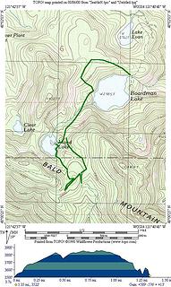
This is the Bald Mountain south of the mountain loop highway and north of Spada Lake.
My mistake was hanging around Verlot campground too long enjoying coffee and breakfast on a very pleasant morning. I didn't start hiking until almost noon. Between the rough trails, bushwhacking and repeated ups and downs along the ridge I ran out of time.
My route was to take the popular trail to Boardman Lake, the fisherman's trail to Island Lake, bushwhack up to the Bald Mountain trail, then follow that to the top. Even though this cuts off some of the mileage, it's still a big hike -- it took me 6 hours moving quickly with only a few brief rest stops to eat snacks. I'd allow 8 to provide time to reach the actual summit and take it a little easier.
Island Lake is an exceptionally beautiful lake with a primo campsite on the north side. The Bald Mountain trail is overgrown, has frequent blow down, and is very hard to follow in places. On the way back I briefly lost it 4 or 5 times with plenty of light, and I'm good at following trails. This is not a trail one would want to navigate with a headlamp.
I was surprised by how rugged the summit and south side of Bald Mountain is. I'm going to give it one more try when the Mallardy Ridge road is open again. Assuming no road walk, that route is shorter and passes through the reportedly gorgeous Cutthroat Lakes area.
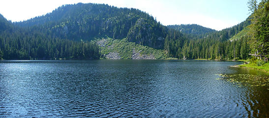 Boardman Lake. My route was through the gap on the right. 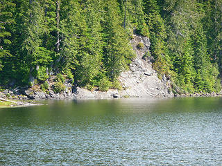 The annoying rock that forces one to climb up 50 feet while traversing around Boardman Lake 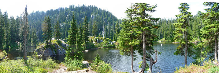 Island Lake. There's a beautiful campsite where I'm standing 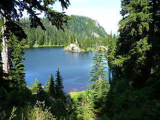 I could not find any trails continuing past Island Lake so I bushwhacked half a mile to connect with the Bald Mountain trail. This is looking back toward the scenic Island Lake 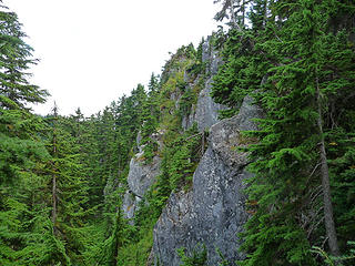 About 1-1/2 hours after hitting the Bald Mountain trail, I reached the point where it gets on top of the Bald Mountain ridge. The cliffs are already impressive. 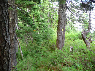 The trail was often indistinct, but these occasional yellow diamond trail markers were reassuring. 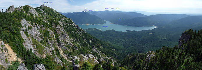 Bald Mountain attempt 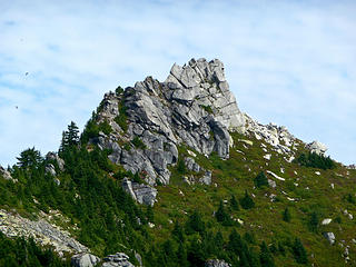 Summit of Bald Mountain. It looks hard from this side, but the guide book indicates a class 2/3 route from the other side. 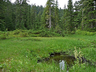 The Bald Mountain trail passes through several pleasant meadows, some with established campsites. 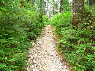 After my day on indistinct and non-existent trails, this last section from Boardman Lake looked like a freeway.
|
| Back to top |
  
|
|
camut
Member

Joined: 17 Aug 2006
Posts: 329 | TRs | Pics
Location: stanwood |
|
camut
Member
|
Mon Sep 07, 2009 6:48 am |
|
|
Bald Mt. is a short easy scramble from the other side.
|
| Back to top |
|
|
Hulksmash
Cleaning up.

Joined: 20 Apr 2008
Posts: 7113 | TRs | Pics
Location: Arlington |
|
Hulksmash
Cleaning up.
|
Mon Sep 07, 2009 9:32 am |
|
|
"Bears couldn't care less about us....we smell bad and don't taste too good. Bugs on the other hand see us as vending machines." - WetDog
Albuterol! it's the 11th essential
|
| Back to top |
|
|
Scrooge
Famous Grouse

Joined: 16 Dec 2001
Posts: 6966 | TRs | Pics
Location: wishful thinking |
|
Scrooge
Famous Grouse
|
Mon Sep 07, 2009 10:07 am |
|
|
Fond memories.  My first ever bushwhack involved Island Lake and the Bald Mountain Trail. My first ever bushwhack involved Island Lake and the Bald Mountain Trail.
 Boardman Lake > Bald Mountain Trail > Island Lake > Boardman Lake 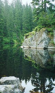 island lake  I was very proud of myself.
Hulk must be some kind of mountain goat. I've been up and around that damn rock pier, every single trip to Island Lake (and there've been a bunch).
I was very proud of myself.
Hulk must be some kind of mountain goat. I've been up and around that damn rock pier, every single trip to Island Lake (and there've been a bunch).
Something lost behind the ranges. Lost and waiting for you....... Go and find it. Go!
Something lost behind the ranges. Lost and waiting for you....... Go and find it. Go!
|
| Back to top |
|
|
Joey
verrry senior member

Joined: 05 Jun 2005
Posts: 2797 | TRs | Pics
Location: Redmond |
|
Joey
verrry senior member
|
Mon Sep 07, 2009 12:34 pm |
|
|
Just SW of Island Lake is a bump on the ridge around 4,200'. That bump actually consists of 2 separate high points. We visited both this summer via the west end of the Bald Mtn trail and a short/easy scramble.
Alas, there were too many trees to get much of a view down to Island Lake, otherwise I would have posted a pic in the name-that-lake thread.
|
| Back to top |
|
|
Hulksmash
Cleaning up.
Joined: 20 Apr 2008
Posts: 7113 | TRs | Pics
Location: Arlington |
|
Hulksmash
Cleaning up.
|
Mon Sep 07, 2009 12:42 pm |
|
|
| Quote: | | Hulk must be some kind of mountain goat. I've been up and around that damn rock pier, every single trip to Island Lake (and there've been a bunch). |
 Ok...Ok...I admit that rock is a little imposing with a pack overflowing with trash. Ok...Ok...I admit that rock is a little imposing with a pack overflowing with trash. 
"Bears couldn't care less about us....we smell bad and don't taste too good. Bugs on the other hand see us as vending machines." - WetDog
Albuterol! it's the 11th essential
"Bears couldn't care less about us....we smell bad and don't taste too good. Bugs on the other hand see us as vending machines." - WetDog
Albuterol! it's the 11th essential
|
| Back to top |
|
|
puzzlr
Mid Fork Rocks
Joined: 13 Feb 2007
Posts: 7220 | TRs | Pics
Location: Stuck in the middle |
|
puzzlr
Mid Fork Rocks
|
Mon Sep 07, 2009 10:53 pm |
|
|
Thanks for the info on the Mallardy road bridge, and possible access in the future. The oars were still there, leaning against a tree. If I had know they were trash I would have taken them out.
|
| Back to top |
|
|
|
|


 At least they chose a dead tree.


 I sopped at Verlot to inquire...closed of course

