| Previous :: Next Topic |
| Author |
Message |
Ancient Ambler
Member


Joined: 15 May 2007
Posts: 1092 | TRs | Pics
Location: Bainbridge Island |
With a sense of foreboding verging on dread, took off through the rain toward the Olympics  . Weather service had issued dire warnings of an inch or more of rain, plunging snow levels and danger of hypothermia. Things were not looking good.
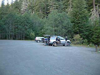
Except for the blue sky we saw to the west as we passed the Port Townsend turnoff. Except for the blue sky overhead as we pulled in to the amazingly empty parking lot for the Dungeness trails. Less than 10 cars parked at this massive parking lot, on the first day of the Labor Day weekend? Looked like almost everyone else got the memo about how horrible the weather was going to be. . Weather service had issued dire warnings of an inch or more of rain, plunging snow levels and danger of hypothermia. Things were not looking good.
Except for the blue sky we saw to the west as we passed the Port Townsend turnoff. Except for the blue sky overhead as we pulled in to the amazingly empty parking lot for the Dungeness trails. Less than 10 cars parked at this massive parking lot, on the first day of the Labor Day weekend? Looked like almost everyone else got the memo about how horrible the weather was going to be.
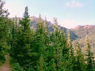
 Almost empty Dungeness TH parking lot 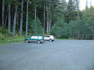 Almost empty Dungeness TH lot 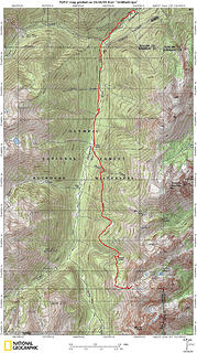 Route to Charlia Pass 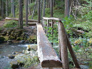 bridge across Royal Creek 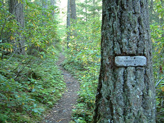 Stay left here 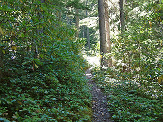 sunny trail 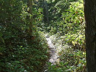 upper Dungeness trail 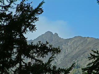 blue sky over Petunia Peak 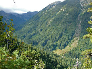 sun on the upper Dungeness 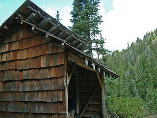 Boulder Shelter 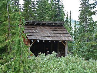 Boulder Shelter 2 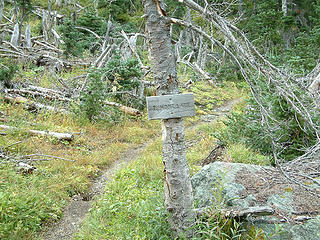 Trail toward Constance Pass from Boulder Shelter 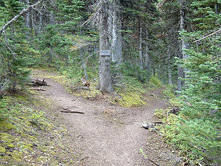 turn left here for Charila way trail; Constance Pass to right 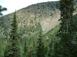 Trail toward Marmot Pass viewed from Charlia way trail 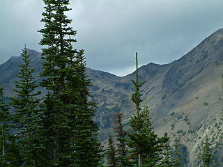 3 labels upper Fricaba basin from Charlia way trail 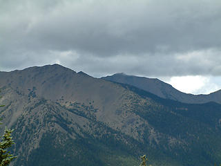 1 label Gray Wolf Mountain from Charlia way trail 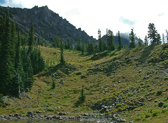 1 label Cloudy Peak (6974) from Charlia way trail 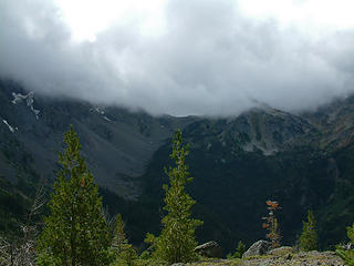 1 label Constance Pass from Charlia way trail 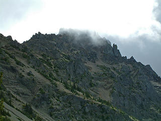 1 label Warrior from Charlia way trail 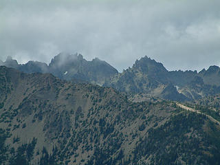 2 labels Mts Johnson and Clark from Charlia 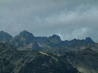 3 labels Clark, Adelaide, Walkinshaw from Charlia 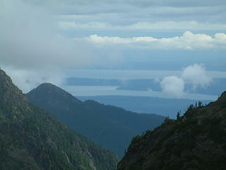 1 label Hood Canal and Puget Sound from Charlia Pass 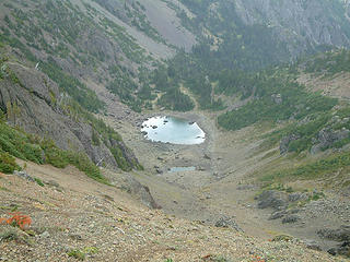 upper Charlia Lake 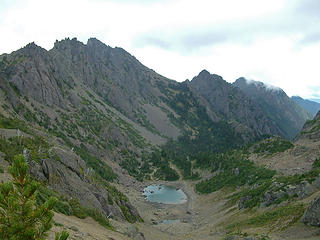 Boulder Ridge from Charlia Pass 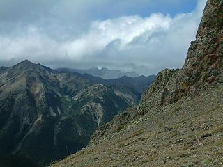 Incoming weather from Charlia Pass 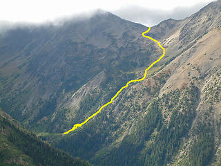 4 labels backdoor route to Deception Basin viewed from Charlia Pass 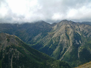 3 labels Fricaba, Hal Foss from Charila Pass 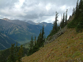 1 label view N down upper Dungeness valley from Charlia 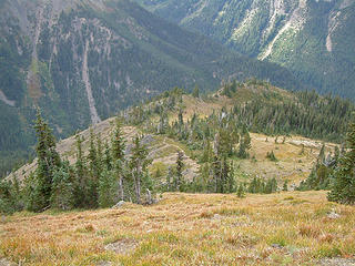 route down from Charlia Pass
|
| Back to top |
  
|
|
El Dooder
Green Earth Bum

Joined: 15 Jul 2007
Posts: 240 | TRs | Pics
Location: Olympia, Washington |
|
El Dooder
Green Earth Bum
|
 Sun Sep 06, 2009 2:30 pm |
|
|
Nice route and glad to see the good luck with the weather. I've done that route a couple of times but came in via Marmot Pass. That's one great view looking down the Dungeoness valley and up to Inner Constance.  Nice pix too. I like that route shot of Heather Creek to Deception Basin.
|
| Back to top |
|
|
RodF
Member

Joined: 01 Sep 2007
Posts: 2593 | TRs | Pics
Location: Sequim WA |
|
RodF
Member
|
Sun Sep 06, 2009 11:28 pm |
|
|
Our experience Saturday, clearing the Little Quil trail, was much like yours!
The Promise: 100% chance rain, gusts to 25 mph, temps 40s.
Special Weather Statement updated 4 pm Friday:
RAIN ASSOCIATED WITH A COLD FRONT DEVELOPING OFFSHORE WILL SPREAD
ACROSS WESTERN WASHINGTON LATER TONIGHT AND SATURDAY MORNING.
RAINFALL AMOUNTS OF A HALF INCH TO AN INCH WILL BE COMMON ALONG
THE COAST AND IN THE MOUNTAINS BY SATURDAY EVENING.
THIS WEATHER PATTERN WILL HAVE THE GREATEST IMPACT ON THE
MOUNTAIN BACKCOUNTRY...AND PEOPLE PLANNING TRIPS THERE SHOULD BE
PREPARED FOR POTENTIALLY DANGEROUS COLD AND WET WEATHER.
THE SNOW LEVEL WILL FALL TO AROUND 6000 FEET BY SUNDAY...AND ONE
TO TWO FEET OF NEW SNOW IS EXPECTED TO FALL ABOVE THE SNOW LEVEL.
WINDS OF 25 TO 40 MPH SHOULD BE EXPECTED ON HIGHER EXPOSED RIDGES
AND SLOPES...AND THERE IS A POSSIBILITY OF THUNDER AND LIGHTNING.
DAYTIME TEMPERATURES ABOVE 4000 FEET WILL REMAIN BELOW 50 DEGREES.
The Reality: none of the above, very pleasant!
 Little Quil towards Mt Townsend, by Mark
"of all the paths you take in life, make sure a few of them are dirt" - John Muir
"the wild is not the opposite of cultivated. It is the opposite of the captivated - Vandana Shiva
"of all the paths you take in life, make sure a few of them are dirt" - John Muir
"the wild is not the opposite of cultivated. It is the opposite of the captivated - Vandana Shiva
|
| Back to top |
|
|
Ancient Ambler
Member
Joined: 15 May 2007
Posts: 1092 | TRs | Pics
Location: Bainbridge Island |
RodF,
Looks like we got lucky and dodged a bullet by heading into the northeastern Olympics on Saturday. The National Weather Service was right to warn hikers about bad weather for the Labor Day weekend, based on the weather stats from Hurricane Ridge since Saturday. While we had strong winds and cold temps above 6000 ft on Saturday at Charlia Pass, it was nothing like the 60 mph gusts recorded at Hurricane on Saturday. And given temps at Hurricane in the 30s on Sunday coupled with very strong winds, I'm thankful I wasn't up in the Olympics overnight this weekend.
Weather Conditions for:
HURRICANE, WA (HURW1)
Elev: 5200 ft; Latitude: 47.9706; Longitude: -123.4983
Current time: Mon, 07 Sep 6:43 am (PDT)
Most Recent Observation: Mon, 07 Sep 6:00 am (PDT)
Time Temp. Dew Relative Wind Wind Wind Solar Solar Precip Precip Precip Precip 24 Hr 24 Hr Quality
Point Humidity Chill Direction Speed Radiation Pct Accumulated 1 hour 6 hour 24 hour Max Min Control
(PDT) (f) (f) (%) (f) (mph) (W/m*m) of psbl (inches) (inches) (inches) (inches) Temp Temp
07 Sep 6:00 am 36 36 100 WNW G20 0 -- 16.14 0.02 0.03 0.44 OK
07 Sep 5:00 am 37 37 100 SW 1G17 1 -- 16.12 0.01 0.01 0.42 OK
07 Sep 4:00 am 35 35 100 WSW 7G18 0 -- 16.11 0.01 0.41 OK
07 Sep 3:00 am 35 35 100 NE 7G20 0 -- 16.11 0.01 0.42 OK
07 Sep 2:00 am 36 36 100 29 NNW 9G21 0 -- 16.11 0.03 0.47 OK
07 Sep 1:00 am 36 36 100 NW 8G23 0 -- 16.11 0.08 0.48 OK
07 Sep 12:00 am 34 34 100 26 NNW 10G22 0 -- 16.11 0.08 0.56 OK
06 Sep 11:00 pm 34 34 100 W 7G28 0 -- 16.11 0.01 0.11 0.58 OK
06 Sep 10:00 pm 34 34 100 25 ENE 12G29 0 -- 16.10 0.18 0.58 OK
06 Sep 9:00 pm 34 34 100 25 ESE 12G30 0 -- 16.10 0.02 0.20 0.58 OK
06 Sep 8:00 pm 36 36 100 27 N 13G34 0 0 16.08 0.05 0.20 0.56 OK
06 Sep 7:00 pm 37 37 100 27 WSW 17G30 13 4% 16.03 0.19 0.51 OK
06 Sep 6:00 pm 37 37 100 27 WSW 17G29 35 6% 16.03 0.03 0.19 0.51 OK
06 Sep 5:00 pm 35 35 100 26 ENE 14G30 6 1% 16.00 0.08 0.17 0.48 OK
06 Sep 4:00 pm 36 36 100 27 NW 15G33 25 3% 15.92 0.02 0.10 0.40 OK
06 Sep 3:00 pm 37 37 100 29 NW 12G36 45 4% 15.90 0.02 0.08 0.38 48 36 OK
06 Sep 2:00 pm 35 35 100 24 N 18G31 19 2% 15.88 0.04 0.10 0.37 OK
06 Sep 1:00 pm 37 37 100 29 E 13G39 79 7% 15.84 0.14 0.34 OK
06 Sep 12:00 pm 37 37 100 28 N 16G42 59 6% 15.84 0.01 0.14 0.34 OK
06 Sep 11:00 am 36 36 100 26 NW 17G48 213 24% 15.83 0.01 0.13 0.34 OK
06 Sep 10:00 am 35 35 100 22 SW 26G46 108 16% 15.82 0.12 0.33 OK
06 Sep 9:00 am 34 34 100 22 SE 23G35 47 10% 15.82 0.04 0.13 0.33 OK
06 Sep 8:00 am 37 37 100 27 SE 18G38 14 8% 15.78 0.08 0.14 0.29 OK
06 Sep 7:00 am 37 37 100 27 NNW 18G33 1 -- 15.70 0.07 0.21 OK
06 Sep 6:00 am 36 36 100 26 SE 16G37 0 -- 15.70 0.15 0.22 OK
06 Sep 5:00 am 37 37 100 26 SW 21G30 0 -- 15.70 0.17 0.23 OK
06 Sep 4:00 am 36 36 100 27 SSE 15G44 0 -- 15.70 0.01 0.18 0.23 OK
06 Sep 3:00 am 38 38 100 29 SW 17G46 0 -- 15.69 0.05 0.17 0.22 OK
06 Sep 2:00 am 39 39 100 28 WNW 23G37 0 -- 15.64 0.01 0.12 0.17 OK
06 Sep 1:00 am 38 38 100 28 S 20G34 0 -- 15.63 0.08 0.11 0.16 OK
06 Sep 12:00 am 40 40 100 32 N 13G39 0 -- 15.55 0.02 0.03 0.08 OK
05 Sep 11:00 pm 39 39 100 29 SE 21G33 0 -- 15.53 0.01 0.01 0.06 OK
05 Sep 10:00 pm 39 38 98 30 SSE 18G32 0 -- 15.52 0.05 OK
05 Sep 9:00 pm 39 37 94 30 SSE 16G30 0 -- 15.52 0.05 OK
05 Sep 8:00 pm 41 37 87 SSE 15G26 0 0 15.52 0.01 0.05 OK
05 Sep 7:00 pm 42 38 86 N 13G24 31 10% 15.52 0.02 0.05 OK
05 Sep 6:00 pm 46 37 71 SSE 11G24 58 10% 15.52 0.02 0.05 OK
05 Sep 5:00 pm 45 39 79 S 12G31 165 21% 15.52 0.03 0.05 OK
05 Sep 4:00 pm 44 40 87 S 12G29 163 17% 15.52 0.03 0.05 OK
05 Sep 3:00 pm 45 40 82 S 16G28 198 18% 15.52 0.01 0.03 0.05 64 41 OK
05 Sep 2:00 pm 43 41 93 S 14G30 424 37% 15.51 0.01 0.02 0.04 OK
05 Sep 1:00 pm 46 41 83 S 13G28 465 41% 15.50 0.01 0.03 OK
05 Sep 12:00 pm 45 45 100 SSE 14G39 302 29% 15.50 0.01 0.02 0.03 OK
05 Sep 11:00 am 43 43 100 SSE 15G47 109 12% 15.49 0.02 0.02 OK
05 Sep 10:00 am 43 41 92 S 21G58 139 20% 15.49 0.02 0.02 OK
05 Sep 9:00 am 42 42 100 S 22G60 133 29% 15.49 0.02 0.02 OK
05 Sep 8:00 am 42 42 100 S 34G45 14 7% 15.49 0.02 0.02 OK
05 Sep 7:00 am 44 44 100 S 23G48 1 -- 15.49 0.01 0.02 0.02 OK
05 Sep 6:00 am 42 42 100 SSE 20G36 0 -- 15.48 0.01 0.01 OK
05 Sep 5:00 am 42 39 89 S 14G42 0 -- 15.47 OK
05 Sep 4:00 am 42 35 76 S 19G40 0 -- 15.47 OK
05 Sep 3:00 am 44 31 60 S 20G32 0 -- 15.47 OK
05 Sep 2:00 am 47 26 44 S 18G32 0 -- 15.47 OK
05 Sep 1:00 am 50 32 49 SSE 14G30 0 -- 15.47 OK
05 Sep 12:00 am 48 35 60 S 19G16 0 -- 15.47 Suspect
|
| Back to top |
|
|
ethorson
Member

Joined: 07 Jun 2007
Posts: 114 | TRs | Pics
Location: Port Townsend |
|
ethorson
Member
|
Mon Sep 07, 2009 8:24 am |
|
|
Great report and photos! It was a good call to head for the NE Olympics. I frequently see the effect of the Olympic rain shadow where I live in Port Townsend. Many times when rain is forecast we end up under a ragged blue hole with a view of Mount Townsend. Charlia Pass looks very pretty and I am definitely going to add it to my list of day hike destinations.
|
| Back to top |
|
|
goats gone wild
Mr. Goat

Joined: 19 Aug 2007
Posts: 2524 | TRs | Pics
Location: Vampireville |
Ambler, Thanks for the beta on the Charlia Lakes route and the back door route to Deception Basin from Heather Creek.
Not only did you take the trip less travelled, but also at a time less travelled. Smarty Pants!  Do you know, does Heather Creek receive any maintenance at all?
.....leaving me wanting to return over and over in what ever capacity that may be, even if one day my knees are too old and I can only see the mountains from my porch.
Jason Hummel
.....leaving me wanting to return over and over in what ever capacity that may be, even if one day my knees are too old and I can only see the mountains from my porch.
Jason Hummel
|
| Back to top |
|
|
bobbi
stillaGUAMish

Joined: 13 Jul 2006
Posts: 8012 | TRs | Pics
Location: olympics! |
|
bobbi
stillaGUAMish
|
Mon Sep 14, 2009 5:38 pm |
|
|
thanks, too, for the info on charlia lakes. on the list
i'll wait for the next 'great' weather weekend 
bobbi ૐ
"Today is your day! Your mountain is waiting. So
get on your way!" - Oh, the Places Youll Go! By Dr. Seuss
bobbi ૐ
"Today is your day! Your mountain is waiting. So
get on your way!" - Oh, the Places Youll Go! By Dr. Seuss
|
| Back to top |
|
|
reststep
Member

Joined: 17 Dec 2001
Posts: 4757 | TRs | Pics
|
|
reststep
Member
|
Mon Sep 14, 2009 6:02 pm |
|
|
Thanks for the report and pictures AA. I really like that area.
GGW, as for Heather Creek here is a quote from a post RodF made earlier this year so it sounds like you are good to go to Deception Basin.
| RodF wrote: | | Our WTA work party cleared ~60 logs from the Heather Creek Trail to the Park boundary. Olympic NF says this is the first time this trail has been completely cleared in at least 20 years. We also borrowed a come-along, choker, two lines and two straps from the contractor, and placed a new footlog across Heather Creek, 5.5 miles from the upper Dungeness trailhead. It is 34 feet long (28' span between sills). |
I really appreciate the work they did.
"The mountains are calling and I must go." - John Muir
"The mountains are calling and I must go." - John Muir
|
| Back to top |
|
|
goats gone wild
Mr. Goat
Joined: 19 Aug 2007
Posts: 2524 | TRs | Pics
Location: Vampireville |
Thank you very much for the info, reststep. Much appreciated.
.....leaving me wanting to return over and over in what ever capacity that may be, even if one day my knees are too old and I can only see the mountains from my porch.
Jason Hummel
.....leaving me wanting to return over and over in what ever capacity that may be, even if one day my knees are too old and I can only see the mountains from my porch.
Jason Hummel
|
| Back to top |
|
|
bobbi
stillaGUAMish
Joined: 13 Jul 2006
Posts: 8012 | TRs | Pics
Location: olympics! |
|
bobbi
stillaGUAMish
|
Mon Sep 14, 2009 8:00 pm |
|
|
goats.....let me know when you are going to do deception basin via heather creek...i am inviting myself along  thanks in advance!
btw: where are my photos? thanks in advance!
btw: where are my photos? 
bobbi ૐ
"Today is your day! Your mountain is waiting. So
get on your way!" - Oh, the Places Youll Go! By Dr. Seuss
bobbi ૐ
"Today is your day! Your mountain is waiting. So
get on your way!" - Oh, the Places Youll Go! By Dr. Seuss
|
| Back to top |
|
|
Timmie
Member
Joined: 05 Jul 2008
Posts: 130 | TRs | Pics
Location: Bremerton |
|
Timmie
Member
|
Tue Sep 15, 2009 11:37 am |
|
|
| Quote: | | based on the weather stats from Hurricane Ridge since Saturday |
I was there -- Windy, visibility <50 ft, cold and wet.
|
| Back to top |
|
|
RodF
Member
Joined: 01 Sep 2007
Posts: 2593 | TRs | Pics
Location: Sequim WA |
|
RodF
Member
|
Tue Sep 15, 2009 3:27 pm |
|
|
| reststep wrote: | GGW, as for Heather Creek here is a quote from a post RodF made earlier this year so it sounds like you are good to go to Deception Basin.
| RodF wrote: | | Our WTA work party cleared ~60 logs from the Heather Creek Trail to the Park boundary. Olympic NF says this is the first time this trail has been completely cleared in at least 20 years. We also borrowed a come-along, choker, two lines and two straps from the contractor, and placed a new footlog across Heather Creek, 5.5 miles from the upper Dungeness trailhead. It is 34 feet long (28' span between sills). |
|
Thanks, reststep, for remembering this. I was offline with WTA clearing Six Ridge Trail all last week.
p.s. My post was in error: this footlog crosses the upper Dungeness (above Milk, below Home/Heather Creeks), and is 44 feet long. We're returning to complete the handrail this weekend.
p.p.s. Backcountry Ranger Bruce said to say "Hello!" to all his friends on NWHikers, and shared a laugh over the silly Quinault iPod tempest here!
"of all the paths you take in life, make sure a few of them are dirt" - John Muir
"the wild is not the opposite of cultivated. It is the opposite of the captivated - Vandana Shiva
"of all the paths you take in life, make sure a few of them are dirt" - John Muir
"the wild is not the opposite of cultivated. It is the opposite of the captivated - Vandana Shiva
|
| Back to top |
|
|
bobbi
stillaGUAMish
Joined: 13 Jul 2006
Posts: 8012 | TRs | Pics
Location: olympics! |
|
bobbi
stillaGUAMish
|
Tue Sep 15, 2009 3:45 pm |
|
|
so is it Bruce that wanted the ipod?  if yes, you should have grabbed from what's his face
hey back to you Bruce! how goes the mt. jupiter area.
b if yes, you should have grabbed from what's his face
hey back to you Bruce! how goes the mt. jupiter area.
b
bobbi ૐ
"Today is your day! Your mountain is waiting. So
get on your way!" - Oh, the Places Youll Go! By Dr. Seuss
bobbi ૐ
"Today is your day! Your mountain is waiting. So
get on your way!" - Oh, the Places Youll Go! By Dr. Seuss
|
| Back to top |
|
|
Sabahsboy
Member

Joined: 18 Jul 2006
Posts: 2484 | TRs | Pics
Location: SW Sno County |
Very nice trip, Ancient Ambler! I went there via Marmot Pass route thence onward to farther beauty spots. Lots of years ago! Thank you for sharing....I love seeing old places I visited...my photos seems forever lost in boxes and boxes marked and stored and stored again. Probably those would be when I was shooting 35 mm slide film (likely, Kodachrome). I had a nice day up there and was surprised at the less than inviting appearance of the lake (you show in photos....kind of a puddle). That area has remarkable botanical displays "in season". Buckhorn Wilderness, too....wish I could do it all, again.
|
| Back to top |
|
|
|
|
You cannot post new topics in this forum
You cannot reply to topics in this forum
You cannot edit your posts in this forum
You cannot delete your posts in this forum
You cannot vote in polls in this forum
|
Disclosure: As an Amazon Associate NWHikers.net earns from qualifying purchases when you use our link(s). |


