| Previous :: Next Topic |
| Author |
Message |
strider
Member

Joined: 24 Aug 2002
Posts: 464 | TRs | Pics
Location: Silverdale |
|
strider
Member
|
 Tue Sep 29, 2009 8:57 pm |
|
|
In the late 70's, with 3 other hippie hiker wannabee's, I went up the fisherman's trail to Box Mt. Lakes. We did TH to the bridge (about 1 mile if I recall correctly) and then up (straight up!!) to Box in one day, carrying 70's era frame packs with an 8 day load. That first day kicked all of our (then still young) @ss's. It was 10+ hours (9+ hours with packs up) to go about 3 miles.
The only flat spot on the climb out of the valley was undoubtedly the spot you overnighted on your way up - it's the only flat spot on that sidehill. Unfortunately for us, there was a Nasty Mean bee's nest right on the trail, right in the middle of the flat. No stopping anywhere near it, this was mid-Sept and the bees were really unhappy with our presence after the first guy stomped Right On the nest. Three of us were seriously nailed multiple times.
The only escapee was the guy in front, which was not me. The escapee bahstid laughed about it for days.
We took 4 days to get to Mica from Upper Rivord - a truly leisurely pace. The ridge walk was so nice that we decided to ration our chow and go back the way we came in rather than go down and out the valley. We went up to the top of Lime Mt. on the way in, and again on the way out, and hit a couple of the other ridgeline high points as well.
That trip is still one of my top hikes ever. I've been lucky enough to get back in to that area a few times since that first awesome trip. My personal vote for all time #1 privy is just off the trail at the meadow about 400 ft below Mica Lake.
On the way down that sidehill on the last day, I wrote a warning note: "Bees 6 feet past the next log across the trail!". I left the note on a stick, on the downhill side of the nest. One of the other victims read my note, borrowed my pencil, and added to my warning " ... and they're mean suckers too!"
Anybody see my note? I've always wondered.....
strider
I've never been lost, but I'm frequently uncertain where my destination might be in relation to where I am at the moment....
strider
I've never been lost, but I'm frequently uncertain where my destination might be in relation to where I am at the moment....
|
| Back to top |
  
|
|
Bedivere
Why Do Witches Burn?

Joined: 25 Jul 2008
Posts: 7464 | TRs | Pics
Location: The Hermitage |
|
Bedivere
Why Do Witches Burn?
|
Tue Sep 29, 2009 9:13 pm |
|
|
Most excellent TR!
It may have been me that Big Steve was thinking of, I remember talking about my trip to Lime Ridge with someone, and how it was pretty crowded up there. That would've been back in the mid '90s.
Back in '04 or '05 we went to Cub & Itswoot lakes and you could drive all the way to the Downey Creek bridge. Too bad they've closed the road so far back now...
|
| Back to top |
|
|
Slugman
Its a Slugfest!

Joined: 27 Mar 2003
Posts: 16874 | TRs | Pics
|
|
Slugman
Its a Slugfest!
|
Tue Sep 29, 2009 9:20 pm |
|
|
I've never been up to those lakes. But I loved the Milk Creek trail. It used to be a fabulous winter hike. One of my favorites is the five giant trees growing from one spot. I'd like to go up there and do some trail clearing. That trail should not be allowed to die out.
|
| Back to top |
|
|
Magellan
Brutally Handsome

Joined: 26 Jul 2006
Posts: 13117 | TRs | Pics
Location: Inexorable descent |
|
Magellan
Brutally Handsome
|
Tue Sep 29, 2009 9:34 pm |
|
|
I have been up Milk Creek three times prior to the washout and I never saw another soul up there. 60 cars and everyone was up the Suiattle somewhere. I know the grove of trees Slugman is talking about. I have a picture of my brother standing in front of it. It was also an incredible valley to see bear sign, although I never saw a bruin up there.
|
| Back to top |
|
|
Vertical Smile
Member

Joined: 21 Jul 2009
Posts: 27 | TRs | Pics
Location: Great Northwest |
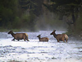
| Tom wrote: | | Vertical Smile, we didn't see any wildlife (other than deer prints here or there). I was a bit surprised. I thought for sure we'd see a bear. However, we generally stay on the go the whole time (other than stopping for lunch and camp). I'm sure if we stayed in a spot for a while we would have seen more wildlife than we did. |
Yeh that seems to be the case with me also. A person can walk right by a number of animals and never see them. It looks like you guys had plenty to look at anyway.
On a side note I see they are rebuilding the bridge at the 10 mile. I wonder if they are going to fix all the roads over there for vehicle access.
Re-duce,
Re-use and
Recycle
Re-duce,
Re-use and
Recycle
|
| Back to top |
|
|
Kim Brown
Member
Joined: 13 Jul 2009
Posts: 6900 | TRs | Pics
|
| Chainsaw_Willie wrote: | | Too bad they've closed the road so far back now... |
It's not that "they've" closed the road. The road is washed out - as in gone - about 50 feet from the roadblock.
"..living on the east side of the Sierra world be ideal - except for harsher winters and the chance of apocalyptic fires burning the whole area."
Bosterson, NWHiker's marketing expert
"..living on the east side of the Sierra world be ideal - except for harsher winters and the chance of apocalyptic fires burning the whole area."
Bosterson, NWHiker's marketing expert
|
| Back to top |
|
|
pimaCanyon
Member

Joined: 13 Jul 2007
Posts: 1304 | TRs | Pics
Location: at the bottom of the map |
| Kim Brown wrote: | | Chainsaw_Willie wrote: | | Too bad they've closed the road so far back now... |
It's not that "they've" closed the road. The road is washed out - as in gone - about 50 feet from the roadblock. |
huh? So how is it that a car drove around the road block and drove the 12 miles that Mike and Tom had bicycled?
It's never too late to have a happy childhood
It's never too late to have a happy childhood
|
| Back to top |
|
|
Dayhike Mike
Bad MFKer
Joined: 02 Mar 2003
Posts: 10958 | TRs | Pics
Location: Going to Tukwila |
The road isn't completely washed out until you get to the Downey Creek bridge. It's horribly undercut in one place, and there are driveable detours into the woods on the left side in the others.
So the road is still driveable in the sense that it's possible to get past there. I suspect they've closed the road to reduce liability and prevent further erosion/collapse in the horribly undercut areas.
My point was that I have no idea why they haven't simply rerouted the road into the woods on the left side in a more formal manner so they could re-open the road.
I mean, it's unfortunate that the road was so close to the river and got undercut in the first place, and it's obvious that they're not going to rebuild the road in that exact same location (too expensive / downright stupid).
The obvious solution is to just reroute the road to the left 40 feet, well away from the rivers edge. I have no idea why they can't simply do that and be done with it.
"There is only one basic human right, the right to do as you damn well please. And with it comes the only basic human duty, the duty to take the consequences." -P.J. O'Rourke
"Ignorance is natural. Stupidity takes commitment." -Solomon Short
"There is only one basic human right, the right to do as you damn well please. And with it comes the only basic human duty, the duty to take the consequences." -P.J. O'Rourke
"Ignorance is natural. Stupidity takes commitment." -Solomon Short
|
| Back to top |
|
|
DIYSteve
seeking hygge

Joined: 06 Mar 2007
Posts: 12655 | TRs | Pics
Location: here now |
|
DIYSteve
seeking hygge
|
Wed Sep 30, 2009 9:43 am |
|
|
I seem to recall some talk about re-routing the road away from the river on WA DNR land, but that the feds and DNR couldn't agree on the terms of an easement. Or something like that. Anybody recall the details of that negotiation?
|
| Back to top |
|
|
Kim Brown
Member
Joined: 13 Jul 2009
Posts: 6900 | TRs | Pics
|
BigSteve - that has been done already - and the reroute has been in place a couple of years. The reroute is at Grade Creek and it is why we can park at m.p. 12.5 for an 11 mile bikeride instead of parking at m.p. 6.
The FS is doing all it can do, given the NEPA requirements that must be adhered to (one of many environmental acts signed by Nixon in the 1970s). The road is closed at m.p. 12.5 to unauthorized motorized use because the re-route hacked in by ATVs and cars is not a road. As it is, a wetland was destroyed by motorized use at the end of the 2nd washout. True, the new road will go through wetlands, but that is after appropriate NEPA studies have been completed and wetland mitigation efforts will be in place.
Authorized motorized use is the FS using ATVs, and if the FS deems it appropriate to authorize an employee on an ATV, they have a right to do so; pointing fingers and saying, "hey , why can't I do that!" is a juvenile attitude.
This road cannot be fixed and re-routes cannot be in place until NEPA requirements mandated by the Federal Government are satisfied.
"..living on the east side of the Sierra world be ideal - except for harsher winters and the chance of apocalyptic fires burning the whole area."
Bosterson, NWHiker's marketing expert
"..living on the east side of the Sierra world be ideal - except for harsher winters and the chance of apocalyptic fires burning the whole area."
Bosterson, NWHiker's marketing expert
|
| Back to top |
|
|
Dayhike Mike
Bad MFKer
Joined: 02 Mar 2003
Posts: 10958 | TRs | Pics
Location: Going to Tukwila |
| Kim Brown wrote: | | Authorized motorized use is the FS using ATVs, not cars/trucks, and if the FS deems it appropriate to authorize an employee on an ATV, they have a right to do so; pointing fingers and saying, "hey , why can't I do that!" is a juvenile attitude. |
I don't think anyone's done that.
I think I was mostly just pissed at the asshat who'd driven his SUV to the end of the road in spite of the obvious signs indicating road closure back at MP 12.
"There is only one basic human right, the right to do as you damn well please. And with it comes the only basic human duty, the duty to take the consequences." -P.J. O'Rourke
"Ignorance is natural. Stupidity takes commitment." -Solomon Short
"There is only one basic human right, the right to do as you damn well please. And with it comes the only basic human duty, the duty to take the consequences." -P.J. O'Rourke
"Ignorance is natural. Stupidity takes commitment." -Solomon Short
|
| Back to top |
|
|
Kim Brown
Member
Joined: 13 Jul 2009
Posts: 6900 | TRs | Pics
|
| Dayhike Mike wrote: | | The obvious solution is to just reroute the road to the left 40 feet, well away from the rivers edge. I have no idea why they can't simply do that and be done with it. |
NEPA !!!
Jeezus, people! 
"..living on the east side of the Sierra world be ideal - except for harsher winters and the chance of apocalyptic fires burning the whole area."
Bosterson, NWHiker's marketing expert
"..living on the east side of the Sierra world be ideal - except for harsher winters and the chance of apocalyptic fires burning the whole area."
Bosterson, NWHiker's marketing expert
|
| Back to top |
|
|
Hulksmash
Cleaning up.

Joined: 20 Apr 2008
Posts: 7113 | TRs | Pics
Location: Arlington |
|
Hulksmash
Cleaning up.
|
Wed Sep 30, 2009 10:20 am |
|
|
| Quote: | | Quote: | | Kim Brown wrote:
Authorized motorized use is the FS using ATVs, not cars/trucks, and if the FS deems it appropriate to authorize an employee on an ATV, they have a right to do so; pointing fingers and saying, "hey , why can't I do that!" is a juvenile attitude. |
I don't think anyone's done that.
I think I was mostly just pissed at the asshat who'd driven his SUV to the end of the road in spite of the obvious signs indicating road closure back at MP 12. |
With out going into too much detail, beyond the road closure in addition to Forest Service land, DNR Land, there is a patch work of BLM, land, Private Property, and Sovereign Native American land.
So the individual who drove around the road closure could very well have been authorized to do so.
"Bears couldn't care less about us....we smell bad and don't taste too good. Bugs on the other hand see us as vending machines." - WetDog
Albuterol! it's the 11th essential
"Bears couldn't care less about us....we smell bad and don't taste too good. Bugs on the other hand see us as vending machines." - WetDog
Albuterol! it's the 11th essential
|
| Back to top |
|
|
Dayhike Mike
Bad MFKer

Joined: 02 Mar 2003
Posts: 10958 | TRs | Pics
Location: Going to Tukwila |
Neverending Excuses for Public Annoyances?
Why does everything have to be reduced to an acronym these days? 
| Hulksmash wrote: | | So the individual who drove around the road closure could very well have been authorized to do so. |
No permit was displayed (aside from their Northwest Forest Pass). I think it's naive to assume that they were in the right.
"There is only one basic human right, the right to do as you damn well please. And with it comes the only basic human duty, the duty to take the consequences." -P.J. O'Rourke
"Ignorance is natural. Stupidity takes commitment." -Solomon Short
"There is only one basic human right, the right to do as you damn well please. And with it comes the only basic human duty, the duty to take the consequences." -P.J. O'Rourke
"Ignorance is natural. Stupidity takes commitment." -Solomon Short
|
| Back to top |
|
|
Tom
Admin
Joined: 15 Dec 2001
Posts: 17857 | TRs | Pics
|
|
Tom
Admin
|
Wed Sep 30, 2009 10:28 am |
|
|
|
| Back to top |
|
|
|
|
You cannot post new topics in this forum
You cannot reply to topics in this forum
You cannot edit your posts in this forum
You cannot delete your posts in this forum
You cannot vote in polls in this forum
|
Disclosure: As an Amazon Associate NWHikers.net earns from qualifying purchases when you use our link(s). |


