This trip was on Oct. 4 and 5, 2009
There is a blue line on the USGS quad from Buckhorn Lake to a small tarn near the base of Mt. Buckhorn indicating a stream. That stream is not there as far as I was able to determine.
I took the Tubal Cain Trail and cut down off the trail a little above Buckhorn Pass.
Dusting of snow on ridge above Tull Canyon
Buckhorn Mountain on the way in
Mt. Townsend
Mt. Worthington on the way in
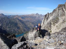
Mt. Buckhorn and Copper Creek Basin
Copper Creek Basin
There are lots of game trails heading into the basin. I didnt see any game but did see tracks of smaller critters in the fresh snow.
Once I got down in the basin I started looking around for a place to camp. It looked very rocky but then I found a spot that was fairly flat and filled in with small what I guess I would call gravel and said "this looks like home for the night".
I set up the tent and the stakes did not want to hold in the loose gravel so I had to reinforce them with boulders of which there were many lying around.
Campsite and Reggie Peak
After that I went looking for water and did not find a stream so I pumped water out of the tarn that was not that far away thus avoiding a dry camp.
The sun soon went behind the mountain and the temperature immediately dropped. I still had plenty of time to heat water and have dinner before it got dark.
Mt. Buckhorn in the evening
The Tarn
Mt. Buckhorn again
It got down to about 28 degrees in the tent. I stayed nice and warm except for my feet. I might have to get some of those down booties. I tried using one of those chemical warmer packs in the bottom of the sleeping bag but it did not seem to help. There was frost on the inside and the outside of the tent in the morning.
After breakfast I went for a walk and then got tired of waiting for the sun so packed up and left. Soon after I left I was back in the sun and it felt very good.
First light on the mountain in the morning
Hurry up sun, get to my campsite
Large camping area near the tarn
Tarn from the slope of Mt. Buckhorn
Mt. Worthington on the way out. Most of the snow is gone.
Mt. Deception and Mt. Mystery
Mt. Baker and Mt. Townsend
Trail work on the Tubal Cain Trail
Sunset on the way home
The tarn from the top of Mt. Buckhorn 10/09/2009
"The mountains are calling and I must go." - John Muir
0
"The mountains are calling and I must go." - John Muir
Wow! I have not been to Buckhorn in several thousand years! My only trips were summer; both caught me in clouds. So, the views were, more or less, denied. The alpine garden rambles up there were extraordinary. Never thought of it a place for fall hiking...and here you have one! Whew! Your photos depict a place akin to far north of Alaska! Amazing. And, you can view parts of the place from Seattle while sipping Starbucks brew! Thank you for the shared adventure!
Thanks for the comments. It was a fun hike.
I went in on the Tubal Cain Trail and according to Wood's book the trailhead elevation is 3300 ft. Buckhorn Pass is 7 miles and the elevation is 5900 ft. The spot I camped at I would estimate to be about a mile further and the elevation was about 6000 ft.
Next time I will try placing a hand warmer between 2 pairs of socks. I wish I had thought of that. Thanks for the tip.
I was using a 3/4 length thermorest. That probably didn't help because there was no insulation under the foot area of my sleeping bag. I have one of those yellow foam pads from MEC that my daughter gave to me. I should have taken it. I am sure it would have helped.
"The mountains are calling and I must go." - John Muir
0
"The mountains are calling and I must go." - John Muir
They make a "foot warmer" version too - it has a sticky side so it can be adhered to your shoe - or the bottom of your sock. I always carry a pair in the winter in the pack along with hand warmers as a backup. They work great in ski boots!
You cannot post new topics in this forum You cannot reply to topics in this forum You cannot edit your posts in this forum You cannot delete your posts in this forum You cannot vote in polls in this forum
Disclosure: As an Amazon Associate NWHikers.net earns from qualifying purchases when you use our link(s).