| Previous :: Next Topic |
| Author |
Message |
puzzlr
Mid Fork Rocks


Joined: 13 Feb 2007
Posts: 7220 | TRs | Pics
Location: Stuck in the middle |
|
puzzlr
Mid Fork Rocks
|
 Tue Oct 20, 2009 5:26 am |
|
|
I apologize that this trip report is exactly a month old, but it's still in season. I hope you'll like some of the pictures as much as I enjoyed climbing this scenic mountain on a day with with such spectacular light and cloud effects. I felt inadequate as a photographer with my (high-end) point-and-shoot, and for once wished I had the energy to lug around a real DSLR.
Gunn Peak has been on my list for a while, but this attempt was triggered by the fine report from dacker, Taehee, and Yana. The news that climbing Gunn didn't involve hours of fighting slide alders was all I needed to know. They covered the details well, so I'll let the captions tell our story.
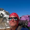
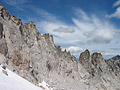
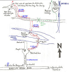 A very helpful map for finding the trail up Gunn Peak. From SummitPost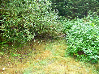 This is the trail leading away from the parking spot. See the tiny pink flagging? 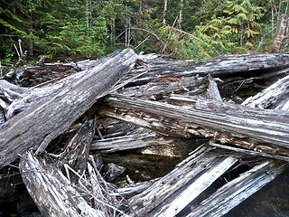 The log jam across Barclay Creek 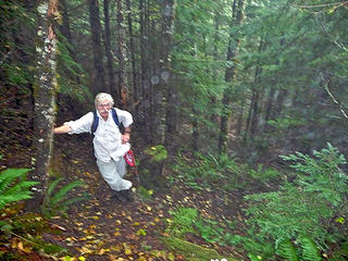 The day was supposed to get increasingly sunnier, but it started out very cloudy and wet in the valley. This is the lower trail before it enters the old growth, and was too dark to get a good shot. 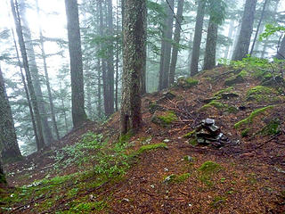 After about an hour the trail gets on top of a forested ridge, shortly before it reaches the base of the cliffs that defend Gunn's south side. 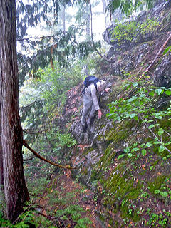 At the cliffs the "trail" traverses to the right, with occasional dicey parts like this. Once again the shot is blurred because of low light conditions. 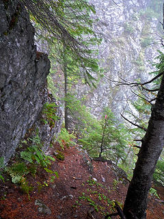 Note the pink flagging indicating that yes, indeed, the route dives down into the steep rocky gully. 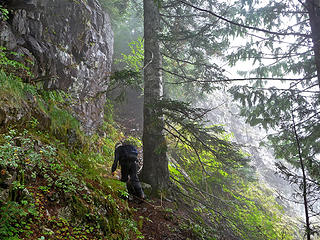 The clouds thinned out occasionally making us think the sun might actually show up, but not quite yet. We just kept following the boot trail, happy that it was there to guide us through the cliff band. 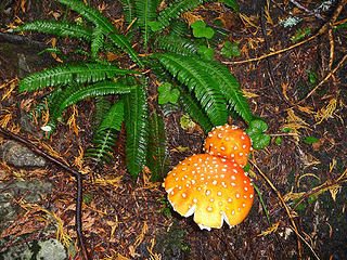 Deer fern and orange mushroom 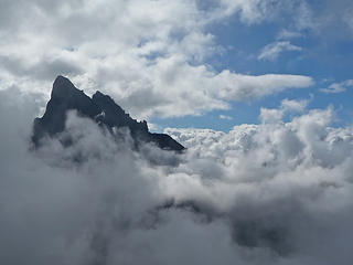 Mt Baring briefly visible through a hole in the clouds. 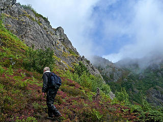 Above the cliff band the route winds through a series of slide alder stands and blueberry patches. I asked Luke to go first to knock the water off the plants because he had rain pants, but there was still plenty left to soak my pants and shoes. On the plus side, the blueberries were plentiful, big and tasty! 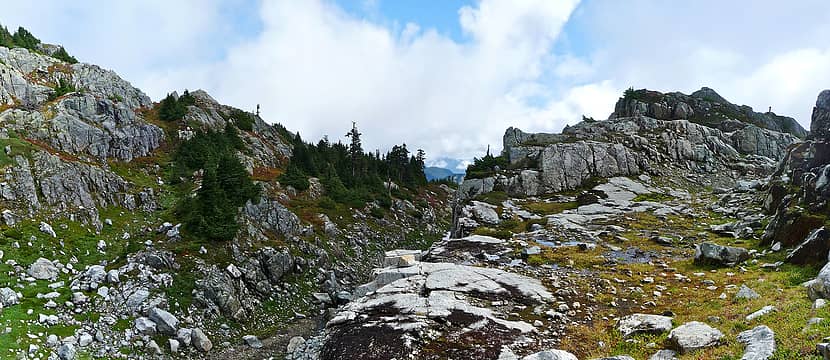 After three hours we reached the top of the Gunn-Merchant ridge, and were starting to enjoy a few sun breaks. The route crosses from right to left in the picture, traversing over the shoulder of the hill on the left. 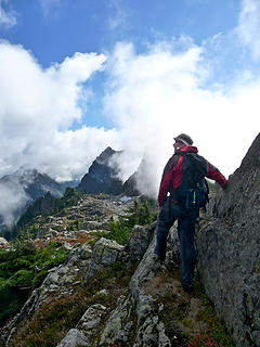 Scrambling down rocks with Merchant Peak in the background. 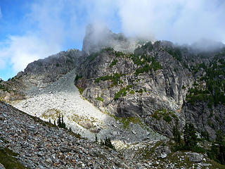 First view of Gunn Peak. We went up the large narrowing talus field at left center, then up through a 3rd class gully onto the smaller talus bench above the cliffs which led to the ridge. 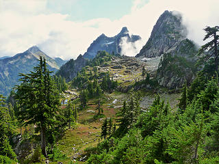 Idyllic meadows on the Gunn-Merchant ridge. If it was easier to get to, I'm sure this would show more signs of human use. It's nice to know there are still some truly wild and unspoiled places just a couple of miles (as the crow flies) from a major highway. 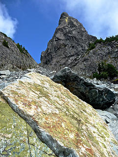 Gunn Peak's summit block towers above rocks in the talus field 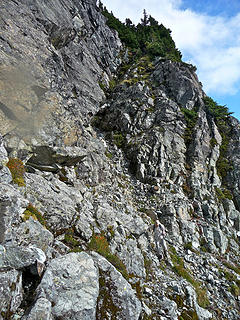 The 3rd class gully that is the crux of the scramble route. We got up easily, but used a hand-line coming down to increase the margin of safety. 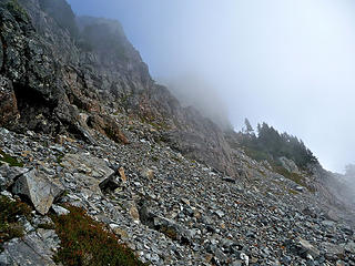 Above the gully is more easy talus leading to the notch in the summit ridge. Earlier reports this year indicated that crossing hard snow on this slope felt very exposed because of cliffs to the right. I'm happy to have rocks. 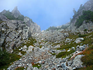 1 label The notch on the summit ridge, directly above. 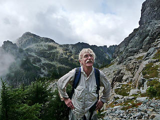 We might just make it! 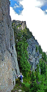 Immediately after going through the notch on the ridge, the route skirts the base of this vertical rock tower. What's not visible is the huge exposure down the north face to the right. 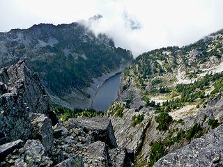 Gunn Lake from the summit 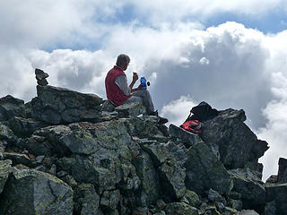 Luke enjoys lunch on Gunn Peak 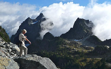 Merchant Peak from Gunn 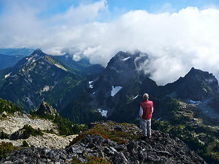 Clearing views as the sun burns away the clouds 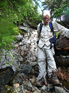 Boots and pants are still wet from the trip up, but the sun is out now 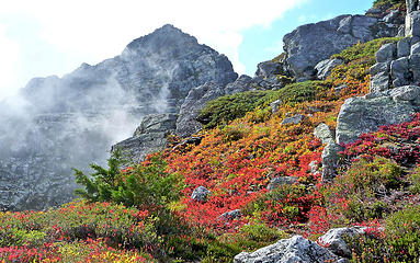 Colorful blueberries on the ridge 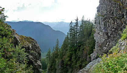 Back at the big gully, we can now see across the valley to the south. 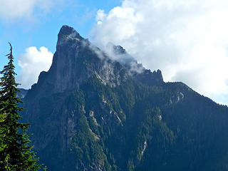 Mt Barring with it's precipitous north face 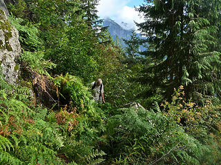 Overgrown, but at least it's a trail 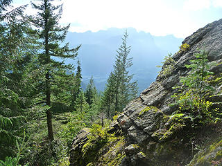 This is where the trail leaves the cliff band and descends quickly through the forest down to Barclay Creek 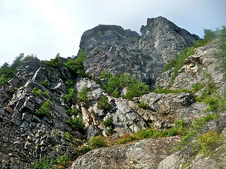 A last look up at the cliff band before we head down into the forest. 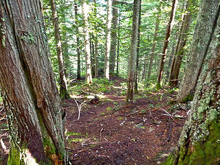 See the trail? 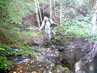 Incredibly, we had more trouble finding the car on the way out than we did finding the trail on the way in. The few visitors to this mountain aren't enough to persist a clear boot trail in the fast-growing undergrowth on the valley bottom. 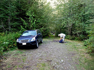 Back at the car, 9 hours after we left.
|
| Back to top |
  
|
|
Magellan
Brutally Handsome

Joined: 26 Jul 2006
Posts: 13117 | TRs | Pics
Location: Inexorable descent |
|
Magellan
Brutally Handsome
|
Tue Oct 20, 2009 5:37 am |
|
|
Strong work fellas. 
|
| Back to top |
|
|
Yana
Hater

Joined: 04 Jun 2004
Posts: 4212 | TRs | Pics
Location: Out Hating |
|
Yana
Hater
|
Tue Oct 20, 2009 6:45 am |
|
|
Thanks for the great photos, puzzlr! I especially like the Baring poking out of the clouds one. We had the same experience on the way out (lost the trail and bushwacked to the stream, then couldn't decide whether we were downstream or upstream of the correct crossing for a few minutes  ). ).
PLAY SAFE! SKI ONLY IN CLOCKWISE DIRECTION! LET'S ALL HAVE FUN TOGETHER!
PLAY SAFE! SKI ONLY IN CLOCKWISE DIRECTION! LET'S ALL HAVE FUN TOGETHER!
|
| Back to top |
|
|
Scrooge
Famous Grouse

Joined: 16 Dec 2001
Posts: 6966 | TRs | Pics
Location: wishful thinking |
|
Scrooge
Famous Grouse
|
Tue Oct 20, 2009 7:58 am |
|
|
A route documentation classic, Puzzlr. By all means add it to the SummitPost - Gunn Peak trip reports section (yours would be a first, for Gunn).
Nice pics for their own sake, too. 
Something lost behind the ranges. Lost and waiting for you....... Go and find it. Go!
Something lost behind the ranges. Lost and waiting for you....... Go and find it. Go!
|
| Back to top |
|
|
BirdDog
Member
Joined: 09 Jan 2007
Posts: 1067 | TRs | Pics
Location: Seattle |
|
BirdDog
Member
|
Tue Oct 20, 2009 8:10 am |
|
|
Nice TR & photos. I love the map, way better than google maps!
"There can be no greater issue than that of conservation in this country."
Teddy Roosevelt August 6, 1912
"There can be no greater issue than that of conservation in this country."
Teddy Roosevelt August 6, 1912
|
| Back to top |
|
|
Gil
Member

Joined: 29 Sep 2004
Posts: 4063 | TRs | Pics
|
|
Gil
Member
|
Tue Oct 20, 2009 9:31 am |
|
|
That is a fantastic image!
Friends help the miles go easier.
Klahini
Friends help the miles go easier.
Klahini
|
| Back to top |
|
|
tigermn
Member

Joined: 10 Jul 2007
Posts: 9242 | TRs | Pics
Location: There... |
|
tigermn
Member
|
Tue Oct 20, 2009 10:43 am |
|
|
|
| Back to top |
|
|
goats gone wild
Mr. Goat

Joined: 19 Aug 2007
Posts: 2524 | TRs | Pics
Location: Vampireville |
Love those deep forest pics. Thanks for a great TR.
.....leaving me wanting to return over and over in what ever capacity that may be, even if one day my knees are too old and I can only see the mountains from my porch.
Jason Hummel
.....leaving me wanting to return over and over in what ever capacity that may be, even if one day my knees are too old and I can only see the mountains from my porch.
Jason Hummel
|
| Back to top |
|
|
Tom
Admin
Joined: 15 Dec 2001
Posts: 17857 | TRs | Pics
|
|
Tom
Admin
|
Tue Oct 20, 2009 1:15 pm |
|
|
Excellent report! Looking at the exposure I'm glad we didn't press on a few years ago when the route was snow covered.
|
| Back to top |
|
|
puzzlr
Mid Fork Rocks
Joined: 13 Feb 2007
Posts: 7220 | TRs | Pics
Location: Stuck in the middle |
|
puzzlr
Mid Fork Rocks
|
Tue Oct 20, 2009 5:02 pm |
|
|
Thanks all. Scrooge -- you'll see those two pictures again. I'm planning on submitting them in the 2010 calendar contest.
|
| Back to top |
|
|
Layback
Cascades Expatriate

Joined: 16 Mar 2007
Posts: 5712 | TRs | Pics
Location: Back East |
|
Layback
Cascades Expatriate
|
Tue Oct 20, 2009 5:26 pm |
|
|
Nice. This one has always intrigued me. Dicey and Tazz? put up a nice snow covered TR of this a couple years ago that got my attention. It's nice to see that it's a fine trip this time of year also.
|
| Back to top |
|
|
twodogdad
Member

Joined: 21 Nov 2006
Posts: 846 | TRs | Pics
Location: seattle |
Thanks, Monty. Your TRs are among the most useful--and dependably beautiful. tdd
|
| Back to top |
|
|
Jim Dockery
Member

Joined: 12 Sep 2007
Posts: 3092 | TRs | Pics
Location: Lake Stevens |
Thanks for the great TR and beta, I've never done it but gotta get it someday.
|
| Back to top |
|
|
|
|


