| Previous :: Next Topic |
| Author |
Message |
Redwic
Unlisted Free Agent


Joined: 23 Feb 2009
Posts: 3292 | TRs | Pics
Location: Going to the Prom(inence) |
|
Redwic
Unlisted Free Agent
|
 Tue Feb 16, 2010 11:01 pm |
|
|
[Editor's Note: I would certainly appreciate labels for the various peaks shown (but not referenced) in the photos included with this TR.]
FZTE and I each did not have to work on President's Day, so I suggested a hike in Wild Sky Wilderness. I had been wanting to summit Beckler Peak and Alpine Baldy for a while, but I kept putting them on the backburner of my hiking aspirations. After checking the weather forecast and projected snow conditions, we agreed to attempt at least Beckler Peak, and possibly also Alpine Baldy if time and conditions allowed.
When we arrived at the parking area at the end of the driveable portion of FS-6066, we looked up at the hillsides above us and saw no snow in the lower portions, so we did not want to have overkill gear on these traditionally "non-technical" peaks. Having heard about favorable snow conditions in the area, we both decided to leave behind my microspikes and his crampons. We began our hike at 7:30 AM.
We traversed up the decommissioned section of road, turning left at the first road intersection, until reaching a creek at ~3350' elevation. We could see frozen footprints in the snow leading up the forested hillside, which we assumed must have been from the Beckler Peak trip involving "Sultan Guy" only nine days prior. The footprints assisted our ascent, although the steep icy lower-southeast slopes of Beckler Peak took us a little by surprise. The icy portions of the terrain were not too difficult to traverse, as long as we kick-stepped and used caution. During some spots that seemed extra-slick, I had FZTE take the lead because he had his heavy-duty boots on that he will use for Mount Everest that were known to be great for kick-stepping. But even with his big-time boots we both took our time during the ascent. Fortunately, the icy sections were randomly spotted throughout the southeast slopes so there was plenty of dirt sections mixed in-between them. We could have each used an ice axe but the conditions were not serious enough for that measure, so our trekking poles were sufficient for this section.
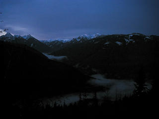
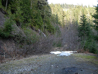 At the parking area... 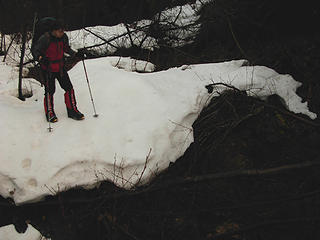 FZTE looks at the stream crossing... 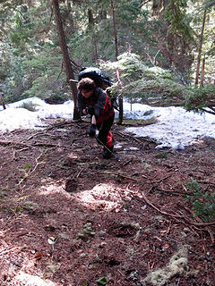 FZTE ascends a steep lower SE slope of Beckler Peak... 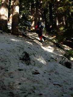 The snow-cover starts becoming commonplace... 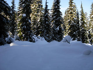 A nice open area to stop for a snack! 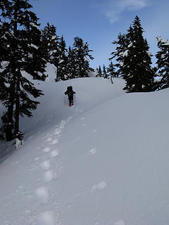 FZTE traverses west along the Beckler Peak ridgetop... 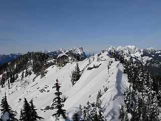 2 labels The West & Middle Peaks of Beckler 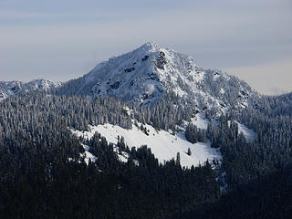 Mount Fernow (6190'), as seen from Beckler Peak 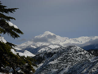 Glacier Peak 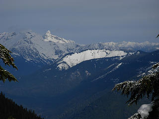 Monte Cristo Peaks, Sloan, Frog... 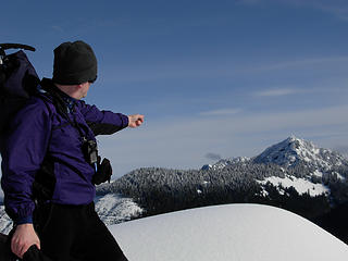 "I'll be coming for you, soon!" 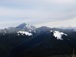 Mount Fernow and Alpine Baldy 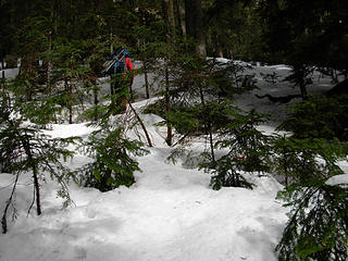 Walking through forest on Alpine Baldy... 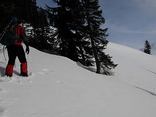 Entering open terrain on Alpine Baldy (finally)... 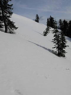 A good place to avoid (due to avalanche danger) 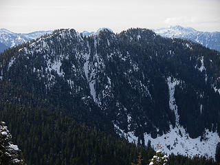 Beckler Peak, as seen from Alpine Baldy 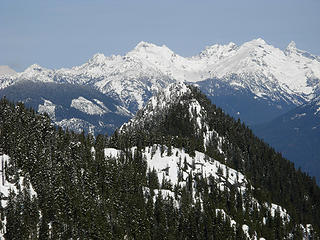 Wowsers!!! 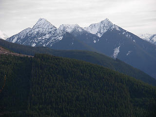 Someday... 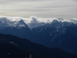 Sweet view!!! 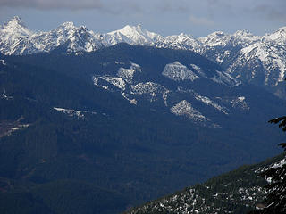 Simply gorgeous!!! 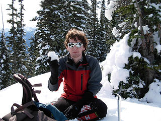 Snow cone, anyone? 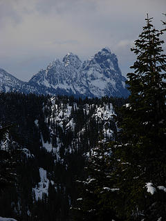 Mount Baring, as seen from Alpine Baldy 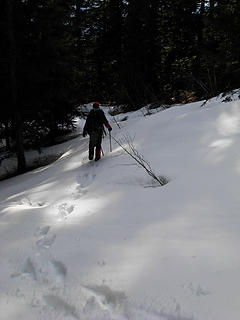 FZTE descends south on Alpine Baldy... 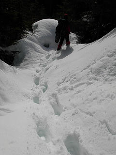 Heading down a snow-covered seasonal stream...
60 pounds lighter but not 60 points brighter.
60 pounds lighter but not 60 points brighter.
|
| Back to top |
  
|
|
fzte
All in the Boots

Joined: 27 Dec 2009
Posts: 85 | TRs | Pics
Location: Edmonds, WA |
|
fzte
All in the Boots
|
Wed Feb 17, 2010 4:25 pm |
|
|
| Redwic wrote: | | Special kudos to FZTE, who is becoming a quick-study and good partner in terms of mountaineering. If he keeps it up, he has a bright future ahead. |
Thanks! It was a fun trip with a few unexpected surprises thrown our way to make things a bit more challenging. Beckler had some great views and is well worth a trip.
 An early start 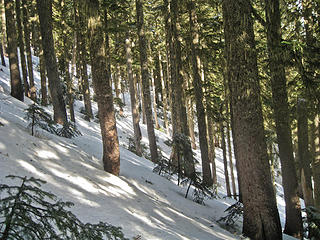 Snow and ice on the way up Beckler 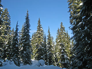 Clearing on Beckler 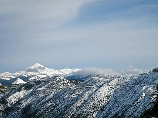 Glacier Peak in the distance 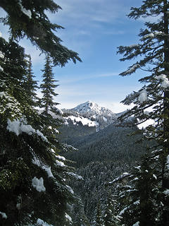 Mount Fernow peeking through the trees 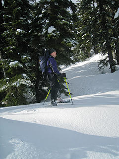 Redwic blazes trail 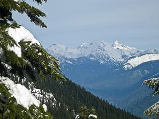 View from Beckler ridge 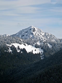 Mount Fernow 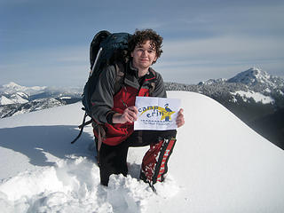 Me on Beckler summit 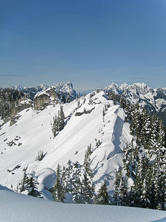 Beckler Middle and West peaks 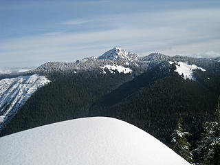 Mount Fernow from Beckler East Peak 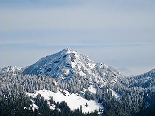 Mount Fernow
|
| Back to top |
|
|
Eric
Peak Geek

Joined: 21 Oct 2002
Posts: 2062 | TRs | Pics
Location: In Travel Status |
|
Eric
Peak Geek
|
Thu Feb 18, 2010 9:40 am |
|
|
Thanks for the TR.
As for as the topic of which peak is highest on Beckler, the GPS and altimeter info is nice but I don't think you can put too much stock in it. Since you have one 5062 contour and 3x 5040-5080 contours you are talking about vertical differences of <22 feet between them (if the map is correct). Those sorts of margins are really less than what a commercial GPS or altimeter can be relied upon to accurately measure. Now if it were 100 feet or more difference then that is good evidence but at that point you could probably tell by sight anyway.
|
| Back to top |
|
|
Scrooge
Famous Grouse

Joined: 16 Dec 2001
Posts: 6966 | TRs | Pics
Location: wishful thinking |
|
Scrooge
Famous Grouse
|
Thu Feb 18, 2010 11:41 am |
|
|
Lots of good beta, Redwic, the kind of thing that makes nwhikers such a good resource. Great pics, both of you.
FZTE, (belated) welcome to the forum. Glad to see that this group of old fogy hikers is continuing to attract the youngest generation of hikers and climbers.
Okay, nwhikers, I know some of you are still pretty young, but you're definitely working on the fogy. 
Something lost behind the ranges. Lost and waiting for you....... Go and find it. Go!
Something lost behind the ranges. Lost and waiting for you....... Go and find it. Go!
|
| Back to top |
|
|
Highwalker's Daughter
Member
Joined: 12 Aug 2006
Posts: 1575 | TRs | Pics
Location: Bothell, WA |
|
| Back to top |
|
|
Quark
Niece of Alvy Moore

Joined: 15 May 2003
Posts: 14152 | TRs | Pics
|
|
Quark
Niece of Alvy Moore
|
Thu Feb 18, 2010 8:40 pm |
|
|
FZTE, can you tell us about yourself again, and the The Moyer Foundation sign. (I know what the Moyer Fdn is, but is this a fund-raising thing)
You've done some really nice trips. 
"...Other than that, the post was more or less accurate."
Bernardo, NW Hikers' Bureau Chief of Reporting
"...Other than that, the post was more or less accurate."
Bernardo, NW Hikers' Bureau Chief of Reporting
|
| Back to top |
|
|
EastKing
Surfing and Hiking

Joined: 28 Mar 2007
Posts: 2082 | TRs | Pics
Location: 77 miles from Seattle! |
|
EastKing
Surfing and Hiking
|
Thu Feb 18, 2010 11:34 pm |
|
|
Great TR and pics! Wish I did not have to work that day.
YouTube | SummitPost
Saw the depths of despair. Now I am salvaging what time I have left on Earth.
YouTube | SummitPost
Saw the depths of despair. Now I am salvaging what time I have left on Earth.
|
| Back to top |
|
|
fzte
All in the Boots
Joined: 27 Dec 2009
Posts: 85 | TRs | Pics
Location: Edmonds, WA |
|
fzte
All in the Boots
|
Fri Feb 19, 2010 10:03 am |
|
|
| Quote: | | FZTE, can you tell us about yourself again, and the The Moyer Foundation sign. (I know what the Moyer Fdn is, but is this a fund-raising thing) |
I'm climbing to raise funds and raise awareness for Camp Erin, a bereavement camp for kids started by The Moyer Foundation. As of right now they have about 30 camps in 28 states and I hope to help them expand even more. I've been really lucky to meet some great NWHikers and had the privilege to go on some fun trips with them. I'm in a hurry to get my stuff together for Mount Baker (I'll be sure to post a TR when I get back) so here's the backstory from my website:
| Quote: | | 5 summits. 1 mission.
In November of 2008 my youngest sisters father died of a heart attack while at the gym, just 49 years old. She struggled to cope with the barrage of feelings and felt like she was alone. Camp Erin has helped her immensely and taught her that she is not alone in grief. Over the next 3 years, I am climbing 5 major peaks to help raise awareness of Camp Erin: Mt. Rainier, Denali, Aconcagua, Cho Oyu, and Everest.
"They said I would never run a marathon."
Diagnosed with congenital heart disease at just 6 weeks old, doctors said I would never run a marathon. Twenty years after undergoing life-saving open heart surgery Im ready to take on the world. Join me, Skylar Givens, as I train, prepare and attempt to become the youngest person in the world with heart disease ever to scale Mt. Everest. |
|
| Back to top |
|
|
Redwic
Unlisted Free Agent
Joined: 23 Feb 2009
Posts: 3292 | TRs | Pics
Location: Going to the Prom(inence) |
|
Redwic
Unlisted Free Agent
|
Fri Feb 19, 2010 6:39 pm |
|
|
| Eric wrote: | | Thanks for the TR.
As for as the topic of which peak is highest on Beckler, the GPS and altimeter info is nice but I don't think you can put too much stock in it. Since you have one 5062 contour and 3x 5040-5080 contours you are talking about vertical differences of <22 feet between them (if the map is correct). Those sorts of margins are really less than what a commercial GPS or altimeter can be relied upon to accurately measure. Now if it were 100 feet or more difference then that is good evidence but at that point you could probably tell by sight anyway. |
I guess someone needs to bring some Geological Survey equipment up there, to settle this.  I plan to visit the West Peak and Middle Peak, during a future trip, to find out with better certainty, myself.
60 pounds lighter but not 60 points brighter.
60 pounds lighter but not 60 points brighter.
|
| Back to top |
|
|
Eric
Peak Geek
Joined: 21 Oct 2002
Posts: 2062 | TRs | Pics
Location: In Travel Status |
|
Eric
Peak Geek
|
Fri Feb 19, 2010 9:41 pm |
|
|
Yeah the USGS could have solved all of these with more spot elevations.
The easiest thing is probably just to tag all possibilities in most cases and then you are covered. This case is expecptional, in that one of the possibilities it tricky enough that doing so takes more.
A small sight level of 8x or 16x or 32x can help with this sort of thing. But ideally you still want to sight in both directions which means tagging all possibilities which means you've been to the summit anyway so what is the point? Just curiosity I guess. But it can confirm what your eyes see a bit more objectively.
Another option it is to get on what you think is the highest peak and get your eye level at the summit level. Then look at the other summit. Identify background peaks. If you can find something in the background with a known elevation that is lower than your contending summits and if it appears higher than the other summit then that means your other summit is lower. Curvature of the earth distorts things but will always "harm" a more distant peak by a greater amount so it still works. Provided you've done everything right. Things get pretty silly if you want to be anal retentive.
Or you can always just pick a summit, call it good and move on to the next one.
|
| Back to top |
|
|
Redwic
Unlisted Free Agent
Joined: 23 Feb 2009
Posts: 3292 | TRs | Pics
Location: Going to the Prom(inence) |
|
Redwic
Unlisted Free Agent
|
Sun Feb 21, 2010 2:58 pm |
|
|
Gimpilator went up to Beckler Peak on Thursday. Then, on Friday, we talked about this very subject. He had his own opinions about things, so he used some sort of method using maps, known information, and photos, to create a trigonometry equation to determine the highest point. I think he used the Middle Peak as his highpoint of choice.
The result? Inconclusive, as the elevation(s) he came up with were well within the margin of error (i.e. a few feet of 5062').
As what Eric suggested, the best way might be to just go up each of the points, just to be certain. But the lack of exact fact-based knowledge rather than speculative knowledge makes me very interested to determine the exact "true" summit. I think a future trip might be worthwhile, to put this to rest (at least in my mind).
60 pounds lighter but not 60 points brighter.
60 pounds lighter but not 60 points brighter.
|
| Back to top |
|
|
Conrad
Meadow bagger
Joined: 25 Aug 2006
Posts: 2298 | TRs | Pics
Location: Moscow, ID |
|
Conrad
Meadow bagger
|
Sun Feb 21, 2010 5:49 pm |
|
|
This all begs the question: Why do you care if you touched the exact highest point? I mean, really. 
|
| Back to top |
|
|
Eric
Peak Geek
Joined: 21 Oct 2002
Posts: 2062 | TRs | Pics
Location: In Travel Status |
|
Eric
Peak Geek
|
Sun Feb 21, 2010 7:41 pm |
|
|
If you haven't touched the highest point, you haven't been to the summit. It's anal, but it's the obvious and fair way to prerequisite for considering a summit ascended. At least for those us who like to play these dirty games in the mtns.
Edward Earl has done something software wise that I think more or less matches what it sounds like Gimpilator was trying to do. He created a pixel analysis tool that plays around with that geometry and tries to calculate unknown elevations off of that. He's much more interested in discovering the HP, whereas I have more of a practical interest in doing enough to get the peak. I can't seem to find the link for that at the moment.
One other thing that I saw Edward do once, on Indian Rock, is to use a hose level. Basically, a ~500 hose filled with water and the combination of water and gravity can give a fairly good estimate using that. More info on that setup:
http://www.cohp.org/hose_level.html
|
| Back to top |
|
|
|
|
You cannot post new topics in this forum
You cannot reply to topics in this forum
You cannot edit your posts in this forum
You cannot delete your posts in this forum
You cannot vote in polls in this forum
|
Disclosure: As an Amazon Associate NWHikers.net earns from qualifying purchases when you use our link(s). |


