| Previous :: Next Topic |
| Author |
Message |
Stefan-K
Member


Joined: 10 Aug 2009
Posts: 522 | TRs | Pics
Location: seattle |
|
Stefan-K
Member
|
 Thu Feb 25, 2010 8:21 am |
|
|
I'm going to keep this brief since Andrew has an excellent, and erudite, TR up over at TAY -
This trip was not only fun but educational, expanding, for one, my range of mountain nomenclature to include "sastrugified". We were thinking it was of italian origin but apparently it's from the russian 'zastruga' and refers to"a long wavelike ridge of snow formed by the wind." There were plenty.
Also, much like the Gerdine Glacier upon which we skied but which remains as of yet undocumented on maps, sastrugify also refers to the practice of combining a frozen entrée with one prepared al dente. We put this definition to test on our last night out mixing pasta (frozen) with buckwheat (al dente) for a surprisingly delicious meal. OK OK, so food was getting scarce...
I won't further bore you with culinary details, here's some pics -
Friday afternoon we hoofed it (pack animals we were, literally) up the North Sauk (wow, beautiful old growth trees!) to the Mackinaw Shelter (5.4 miles)
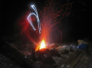 Mackinaw Shelter camp fire 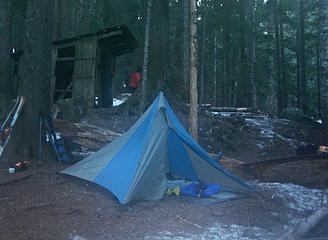 Mackinaw Shelter camp 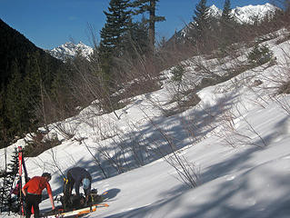 putting on crampons 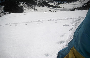 you can see our tracks 1000 feet below crossing the slide path debris 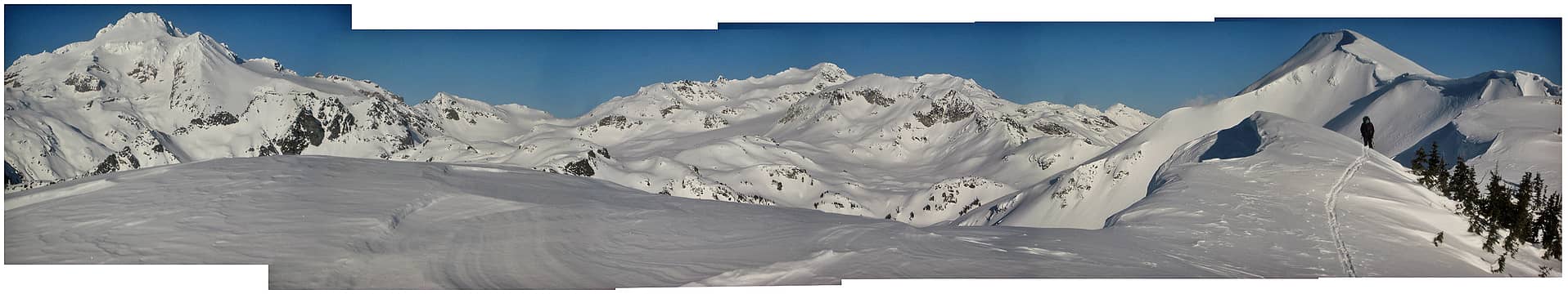 pano on ridge between Red Pass and White Mountain; the distance to Glacier Peak still considerable 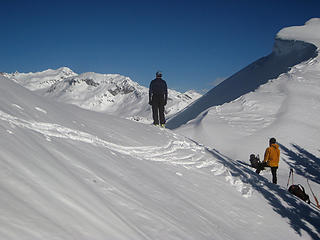 continue on ridge or drop-in here? 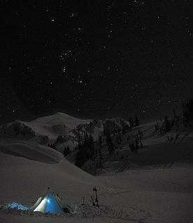 snow camp and stars 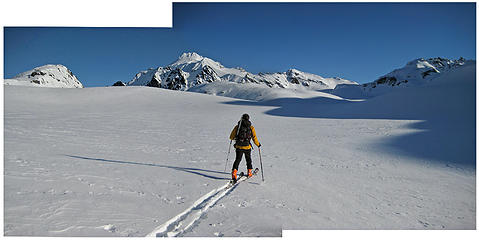 across the White Chuck Glacier flats 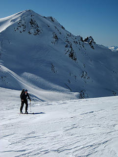 skinning up along the Gerdine Glacier, pt. 7739 behind 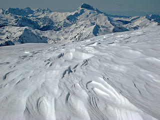 beyond wind scoured topographies: Monte Cristo Peaks, Sloan, Olympics 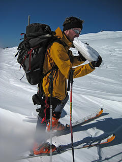 water scarce; snow plenty - Andrew takes advantage 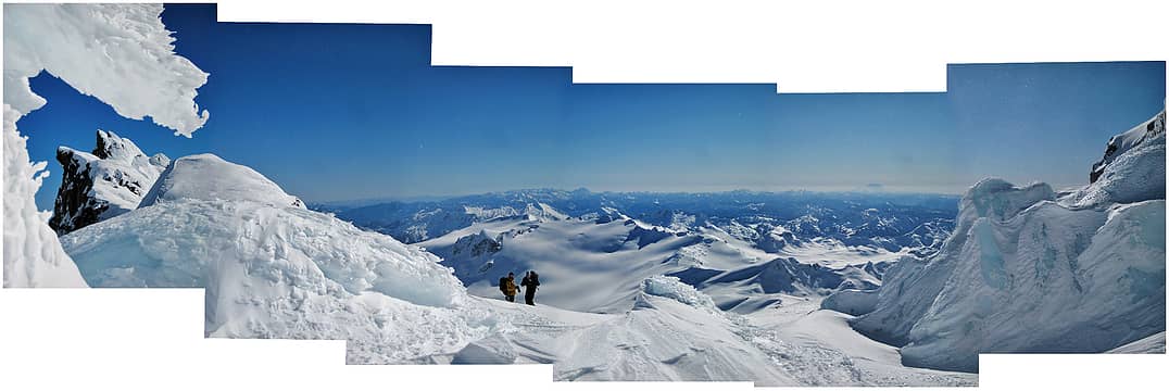 pano looking SE from top of Gerdine Glacier where it meets the Cool Glacier around 9100 ft. On the horizon: Enchantments, Stuart, Daniels, Hinman, Summit Chief & Overcoat, and that big one down South... 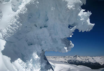 tubed beneath a frozen wave, a view up Dome Peak-wards 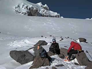 snow melting water and snack time  Andrew skis 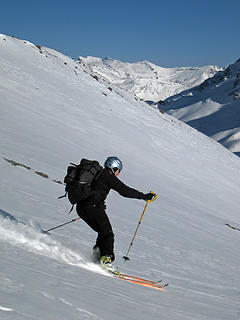 Scott skis 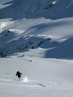 GlacierPeak-022110_11.jpg 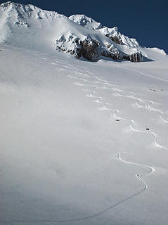 bye 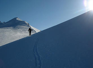 heading back to camp 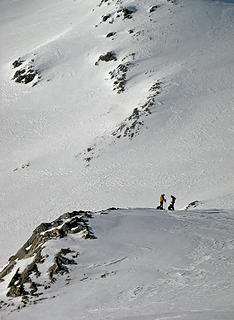 de-skinning 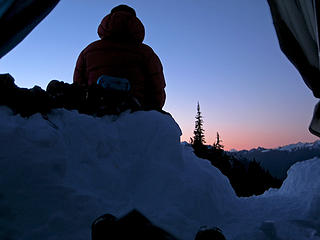 Andrew watches the sun set on Mt. Baker outside our shelter 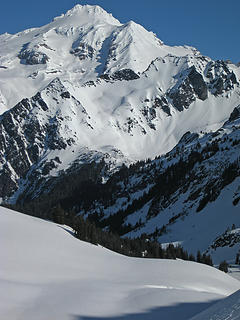 Glacier Peak 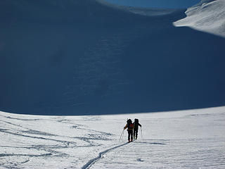 heading out 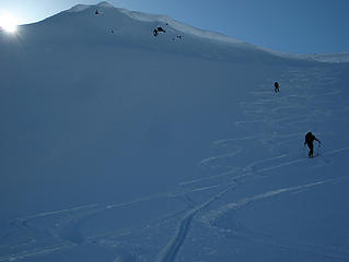 back up and over the ridge 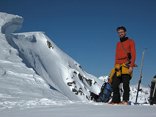 Andrew with Mt. Baker behind the ski 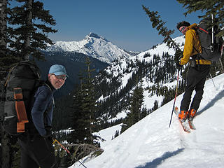 corn side down, Scott and Andrew 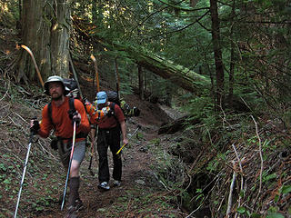 back in the woods
|
| Back to top |
  
|
|
RokIzGud
Cozza Frenzy

Joined: 08 Feb 2010
Posts: 1049 | TRs | Pics
|
|
RokIzGud
Cozza Frenzy
|
Thu Feb 25, 2010 9:34 am |
|
|
Right on, guys! That sounds really fun in the winter. Cant wait to do it in the summer...
|
| Back to top |
|
|
iron
Member

Joined: 10 Aug 2008
Posts: 6392 | TRs | Pics
Location: southeast kootenays |
|
iron
Member
|
Thu Feb 25, 2010 10:43 am |
|
|
|
| Back to top |
|
|
Quark
Niece of Alvy Moore

Joined: 15 May 2003
Posts: 14152 | TRs | Pics
|
|
Quark
Niece of Alvy Moore
|
Thu Feb 25, 2010 11:50 am |
|
|
Marry me, Stefan-K! 
"...Other than that, the post was more or less accurate."
Bernardo, NW Hikers' Bureau Chief of Reporting
"...Other than that, the post was more or less accurate."
Bernardo, NW Hikers' Bureau Chief of Reporting
|
| Back to top |
|
|
Hulksmash
Cleaning up.

Joined: 20 Apr 2008
Posts: 7113 | TRs | Pics
Location: Arlington |
|
Hulksmash
Cleaning up.
|
Thu Feb 25, 2010 12:05 pm |
|
|
"Bears couldn't care less about us....we smell bad and don't taste too good. Bugs on the other hand see us as vending machines." - WetDog
Albuterol! it's the 11th essential
|
| Back to top |
|
|
raising3hikers
Member

Joined: 21 Sep 2007
Posts: 2344 | TRs | Pics
Location: Edmonds, Wa |
That's pretty cool to be that far out in the wilderness in February Thanks for the TR
|
| Back to top |
|
|
Magellan
Brutally Handsome

Joined: 26 Jul 2006
Posts: 13117 | TRs | Pics
Location: Inexorable descent |
|
Magellan
Brutally Handsome
|
Thu Feb 25, 2010 1:20 pm |
|
|
Gorgeous! Good for you guys getting out so deep. Any reason you did not top out?
|
| Back to top |
|
|
TrailPair
Member

Joined: 17 Apr 2005
Posts: 1699 | TRs | Pics
|
We met a member of your party at the North Sauk trail head as we were headed for Painted Mountain....at least he said he was going to ski Glacier Peak....didn't get his name, but he said the rest of the group were already on their way.
Ya'll had a great time! 
This thing called work is interfering with my play
This thing called work is interfering with my play
|
| Back to top |
|
|
Tom_Sjolseth
Born Yesterday

Joined: 30 May 2007
Posts: 2652 | TRs | Pics
Location: Right here. |
Sweet, I thought I may have seen tracks from Sloan Peak, but wasn't sure. Ambitious objective for sure!
|
| Back to top |
|
|
Stefan-K
Member
Joined: 10 Aug 2009
Posts: 522 | TRs | Pics
Location: seattle |
|
Stefan-K
Member
|
Thu Feb 25, 2010 6:11 pm |
|
|
| Magellan wrote: | | Any reason you did not top out? |
Quick answer: we ran out of time. We gave ourselves until 2pm to summit and still have enough time to get back to camp.
Longer answer: in retrospect I think of it mostly as a domino effect... we got off to a lazy start (10am) from the first camp site, the Mackinaw Shelter. We didn't realize the extent of the first leg. From 3,500-5,000 for which we used crampons (and still carrying a full load), would have been more effective, quicker and less strenuous had we left earlier (i.e.harder snow). So leaving earlier would have gained us doubly in time and conditions and would have put our second camp that much closer to the Peak.
Throughout the trip I was continuously reminded of the vastness of Glacier Peak.
Were the road open, the White Chuck / Sitkum Glacier route certainly is a whole lot closer.
|
| Back to top |
|
|
Quark
Niece of Alvy Moore
Joined: 15 May 2003
Posts: 14152 | TRs | Pics
|
|
Quark
Niece of Alvy Moore
|
Thu Feb 25, 2010 6:41 pm |
|
|
A few of us are doing the Sitkum Rt this year.
Such a beautiful mountain. 
"...Other than that, the post was more or less accurate."
Bernardo, NW Hikers' Bureau Chief of Reporting
"...Other than that, the post was more or less accurate."
Bernardo, NW Hikers' Bureau Chief of Reporting
|
| Back to top |
|
|
mtn.climber
Member

Joined: 29 Jul 2008
Posts: 1204 | TRs | Pics
Location: The Lost Horizon |
Q,
Doing the Sitkum route? What trailhead are you entering from. Isn't that the trail that's still closed from floods?
Reach for the sky, cuz tomorrow may never come.
Live the life of love. Love the life you live.
Reach for the sky, cuz tomorrow may never come.
Live the life of love. Love the life you live.
|
| Back to top |
|
|
Bigfoot Jim
Member
Joined: 13 Aug 2007
Posts: 269 | TRs | Pics
|
I think we were given a 'free' extention to wilderness when the roads washed out.
We should rejoice!
|
| Back to top |
|
|
Highwalker's Daughter
Member
Joined: 12 Aug 2006
Posts: 1575 | TRs | Pics
Location: Bothell, WA |
Wonderful photos - such incredible beauty - great trip - even though you didn't make it, it still looks fabulous
|
| Back to top |
|
|
Quark
Niece of Alvy Moore
Joined: 15 May 2003
Posts: 14152 | TRs | Pics
|
|
Quark
Niece of Alvy Moore
|
Thu Feb 25, 2010 8:21 pm |
|
|
| mtn.climber wrote: | | Q,
Doing the Sitkum route? What trailhead are you entering from. Isn't that the trail that's still closed from floods? |
That trail is gone. But interestingly, it's not closed.  Still on Forest Service inventory, as far as I know. They were still out there collecting the trailhead register a couple of summers ago.
But yah, that's what we're doing - the Sitkum route via what's left of the road and a little of the trail. It's going to be a pain in the ass.
I hope our pics are half as good as Stefan-K's. Winter does create some interesting landxcape. Still on Forest Service inventory, as far as I know. They were still out there collecting the trailhead register a couple of summers ago.
But yah, that's what we're doing - the Sitkum route via what's left of the road and a little of the trail. It's going to be a pain in the ass.
I hope our pics are half as good as Stefan-K's. Winter does create some interesting landxcape.
"...Other than that, the post was more or less accurate."
Bernardo, NW Hikers' Bureau Chief of Reporting
"...Other than that, the post was more or less accurate."
Bernardo, NW Hikers' Bureau Chief of Reporting
|
| Back to top |
|
|
|
|


 ...........
  sans the marriage proposal