| Previous :: Next Topic |
| Author |
Message |
evergreenhiker
Hiking Specialist


Joined: 13 Nov 2004
Posts: 367 | TRs | Pics
Location: Gold Bar |
Yesterday my friend John and I finally got Jay Lake. We'd tried few times back in the 90's, but didn't get there due to high water, etc.
This approach is shorter than the Wallace State Park route. Roughly 10.5 miles and 1400-plus ft elevation gain. This is largely a road walk, but bridgeless stream crossings are required in the vicinity of Wallace and Jay Lakes. This is no problem in low water, but as we discovered...if it's high, you may have to get wet!
I will post topo and coordinates on the next post.
Ok, we get there and see a game warden parked at the gate. As I walked by, he rolled the window down and started talk to us. As it turns out, he knew someone that John knows through Search and Rescue. We ended up getting a ride part of the way!  This cut out the boring first 2-plus miles of flattish road walk that goes through a mix of old and newer clearcuts before entering nice woods.
I'll let the pics with captions tell most of the story: This cut out the boring first 2-plus miles of flattish road walk that goes through a mix of old and newer clearcuts before entering nice woods.
I'll let the pics with captions tell most of the story:
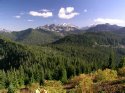
 The starting gate.  Keep straight here.  Olney Creek crossing  pretty cascading stream a bit after the Olney Creek crossing  The game warden dropped us off here. The old road you see will take you to the Shaw lake logging road(wp 005).  John hiking up  Me hiking up  One of many waterfalls  Yet another one.  Pretty ferns!  Keep straight. Left is a route to the Jay Lake saddle(wp 007).  Gate  Very brushy on DNR side  View point a bit past the gate.  Park boundary  Wallace lake road junction  Wallace Lake after the creek crossings  John crossing over  Me crossing on way back from jay  Finally on Jay lake trail  John on Jay lake trail 
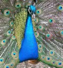
 Another creek crossing  Short flooded section  Jay Lake  Me at Jay Lake  picnic table and firepit  tent sites  Start of route just past campsites  me on the rough trail  No go. Stream high and undercut bank on our side.  Creeping Moss? Very pretty!
The alpine world is my church.
The alpine world is my church.
|
| Back to top |
  
|
|
evergreenhiker
Hiking Specialist
Joined: 13 Nov 2004
Posts: 367 | TRs | Pics
Location: Gold Bar |
|
evergreenhiker
Hiking Specialist
|
 Mon May 31, 2010 11:56 am Jay topo and coordinates
|
|
|
Topo and coordinates:
The alpine world is my church.
The alpine world is my church.
|
| Back to top |
|
|
Smokey Bear
howdy kids

Joined: 21 Mar 2007
Posts: 148 | TRs | Pics
Location: Stanwood |
Thanks for the report and the nice photos. I will be attempting Jay Lake from the west. . . from the Shaw Lake side sometime this summer.
|
| Back to top |
|
|
Hulksmash
Cleaning up.

Joined: 20 Apr 2008
Posts: 7113 | TRs | Pics
Location: Arlington |
|
Hulksmash
Cleaning up.
|
Tue Jun 01, 2010 12:24 am |
|
|
Yea, i think going in from the Shaw lake side well end up being about half the mileage. I just have to get around to it.
"Bears couldn't care less about us....we smell bad and don't taste too good. Bugs on the other hand see us as vending machines." - WetDog
Albuterol! it's the 11th essential
"Bears couldn't care less about us....we smell bad and don't taste too good. Bugs on the other hand see us as vending machines." - WetDog
Albuterol! it's the 11th essential
|
| Back to top |
|
|
GeoHiker
Rocky Walker
Joined: 26 Feb 2005
Posts: 6033 | TRs | Pics
Location: Off the Deep End |
|
GeoHiker
Rocky Walker
|
Tue Jun 01, 2010 1:28 am |
|
|
Great job EGH. I've been wondering about that road. So what was the Game Warden doing in there and did you place a geocache? 
You call some place paradise, kiss it goodbye......Eagles
You call some place paradise, kiss it goodbye......Eagles
|
| Back to top |
|
|
evergreenhiker
Hiking Specialist
Joined: 13 Nov 2004
Posts: 367 | TRs | Pics
Location: Gold Bar |
| GeoHiker wrote: | | Great job EGH. I've been wondering about that road. So what was the Game Warden doing in there and did you place a geocache? |
Thanks. No I didn't hide one there. I've already hid one up at
shaw though! Took over a month due to being State Park land. The Ranger though is very pro geocaching...you just have to go wait for the paperwork to get back from Oly. So if you want to hide one at Jay go ahead. The warden was exploring...getting familiar with the area....sounds like he'd never been up some of those roads.
Parking coords for this hike are in my coordinates image.
The alpine world is my church.
The alpine world is my church.
|
| Back to top |
|
|
Schroder
Member

Joined: 26 Oct 2007
Posts: 6722 | TRs | Pics
Location: on the beach |
|
Schroder
Member
|
Tue Jun 01, 2010 3:18 pm |
|
|
|
| Back to top |
|
|
GeoHiker
Rocky Walker
Joined: 26 Feb 2005
Posts: 6033 | TRs | Pics
Location: Off the Deep End |
|
GeoHiker
Rocky Walker
|
Tue Jun 01, 2010 3:41 pm |
|
|
Your picture of Creeping Moss, does anyone know what this is? I found a patch of this on Mt Pilchuck on a dry out cropping of rock and it looks like a miniature fir tree growing along the ground. Cool stuff.
You call some place paradise, kiss it goodbye......Eagles
You call some place paradise, kiss it goodbye......Eagles
|
| Back to top |
|
|
|
|


