| Previous :: Next Topic |
| Author |
Message |
puzzlr
Mid Fork Rocks


Joined: 13 Feb 2007
Posts: 7220 | TRs | Pics
Location: Stuck in the middle |
|
puzzlr
Mid Fork Rocks
|
 Wed Jul 14, 2010 1:19 am |
|
|
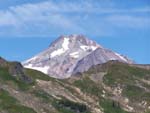
This is very educational. Here's the description for getting to Snoqualmie Mountain. It's nowhere near the current trail because it stays on the Snow Lake Trail 25 minutes. I like the "On the knife edge of the summit .." part!
DESCRIBED BY WASHINGTON GEODETIC SURVEY 1936
THIS STATION IS NW 1/4 OF SEC. 28, T.23, R.11, AND ABOUT 2 MILES N OF THE SUMMIT OF SNOQUALMIE PASS.
TO REACH STATION GO E FROM N BEND TOWARD SUMMIT TO SIGN ON THE N SIDE OF ROAD READING COMMONWEALTH SKI LODGE. TURN LEFT 0.3 MILE TO LODGE. END OF TRUCK TRAVEL. TAKE SNOW LAKE TRAIL WHICH STARTS BEHIND THE LODGE AND GO TO STREAM BED GOING UP MOUNTAIN ABOUT 25-MINUTE HIKE. GO UPSTREAM BED OVER A SERIES OF CLIFFS TO HEAD OF STREAM ABOUT 2-HOUR HIKE. TURN LEFT OR N AND CLIMB 10-FOOT WALL OF STREAM BED. WALK ACROSS SLOPE 10 MINUTES THROUGH BRUSH. COMING INTO THE OPEN CROSS ROCK SLIDE GOING CROSS SLOPE UP HILL. HEAD FOR DRAW IN CLIFF ABOVE ROCK SLIDE. LEAVING THE DRAW, KEEP ON THE STEEP RIDGE TO THE SUMMIT. ON THE KNIFE EDGE OF THE SUMMIT TURN LEFT AND WALK 300 FEET TO STATION, WORK A LITTLE TO THE LEFT OVER TOP OF SMALL HILL AND THEN DOWN TO START.
|
| Back to top |
  
|
|
SlowWalker
Perma-grinner
Joined: 23 Aug 2005
Posts: 888 | TRs | Pics
Location: Seattle |
Great topic. I wonder about that Snoqualmie Mountain description. I suspect the "COMMONWEALTH SKI LODGE" was down near the current Sahale Ski club lodge. Since Alpental wasn't built until the 60's, was the Snow Lake TH much closer to the current PCT trail head?
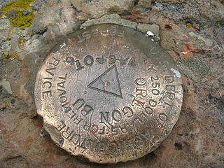
Just for fun, here's a pair of Reference marks fro Granite Mountain.
 029 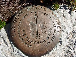 028
|
| Back to top |
|
|
wamtngal
Member

Joined: 13 Jun 2004
Posts: 2382 | TRs | Pics
Location: somewhere |
|
wamtngal
Member
|
Wed Jul 14, 2010 8:24 am |
|
|
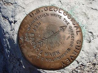
I'm curious who has a photo of the oldest marker out there...I think these might be a couple of the oldest I have (without looking through thousands of photos)...
 No elevation on the benchmark, but it's at 6387' 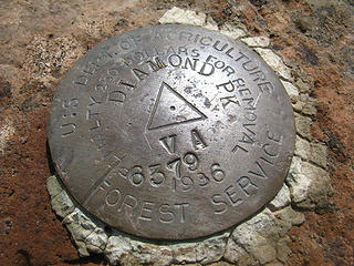 Diamond Pk 6379'
Opinions expressed here are my own.
Opinions expressed here are my own.
|
| Back to top |
|
|
JimK
Member

Joined: 07 Feb 2002
Posts: 5606 | TRs | Pics
Location: Ballard |
|
JimK
Member
|
Wed Jul 14, 2010 8:26 am |
|
|
My original 100 Hikes In Western Washington lists Snow Lake as 11 miles round trip. Here is the start:
| Quote: | | Drive on US 10 to Snoqualmie Pass; park on turnout road across highway from the summit ski area. A large wooden sign-map is prominent; here begins the trail. |
Alpental opened for the 1967-1968 season.
|
| Back to top |
|
|
Benzarino
Member

Joined: 26 Feb 2009
Posts: 309 | TRs | Pics
Location: Bellingham |
Having done geodetic work for the USGS for a summer, I can attest to how much of a pain in the ass it is when folks remove the markers.
PLEASE leave them in the ground. In the unlikely event they are being used for research purposes, you could screw up someone's data! Nothing like hiking up to a summit only to find the benchmark you've been surveying for years has been stolen.
|
| Back to top |
|
|
puzzlr
Mid Fork Rocks
Joined: 13 Feb 2007
Posts: 7220 | TRs | Pics
Location: Stuck in the middle |
|
puzzlr
Mid Fork Rocks
|
Wed Jul 14, 2010 11:10 pm |
|
|
| wamtngal wrote: | Diamond Pk 6379' |
Notice the 6739 elevation stamp. The document link in the OP talks about this. When the benchmark is placed they don't know the elevation because it has to be calculated from the survey data collected on the placement trip. If a party wants to go back later and stamp on the elevation they MUST get permission from the Geodetic Survey to do so. It's clear that this elevation was stamped on later, and none too carefully!
|
| Back to top |
|
|
wamtngal
Member
Joined: 13 Jun 2004
Posts: 2382 | TRs | Pics
Location: somewhere |
|
wamtngal
Member
|
Thu Jul 15, 2010 8:54 am |
|
|
That must be why the Oregon Butte BM doesn't have the elevation stamped on it -- wow, interesting! Learn something new every day.
Opinions expressed here are my own.
Opinions expressed here are my own.
|
| Back to top |
|
|
kleet
meat tornado

Joined: 06 Feb 2002
Posts: 5303 | TRs | Pics
Location: O no they dih ent |
|
kleet
meat tornado
|
Mon Aug 02, 2010 11:32 am |
|
|
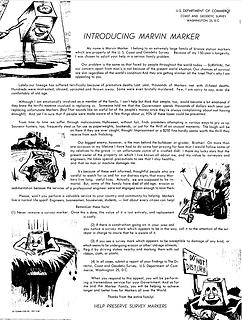 Introducing Marvin Marker  Meet my whole family!
A fuxk, why do I not give one?
A fuxk, why do I not give one?
|
| Back to top |
|
|
DIYSteve
seeking hygge

Joined: 06 Mar 2007
Posts: 12655 | TRs | Pics
Location: here now |
|
DIYSteve
seeking hygge
|
Mon Aug 02, 2010 12:22 pm |
|
|
So, what's with the Star of David? 
|
| Back to top |
|
|
kleet
meat tornado
Joined: 06 Feb 2002
Posts: 5303 | TRs | Pics
Location: O no they dih ent |
|
kleet
meat tornado
|
Mon Aug 02, 2010 1:08 pm |
|
|
| Quote: | | MAGNETIC STATIONS The U.S. Coast & Geodetic Survey began magnetic observations in 1843. The original purpose was to supply magnetic information for the nautical charts, but later observations were extended into the interior to aid local surveyors. The plan was to establish a magnetic station at every county seat and to mark the station for future use. Unfortunately, cultural development eliminated the usefulness of many of the stations that were established. In 1942, the standard for magnetic observations was to make observations at least every 10 miles along a coast and more frequently when magnetic anomalies were found. Stations were marked with natural objects or with bronze or brass Magnetic Station disks. These disks were factory stamped MAGNETIC STATION and with a six-pointed star in the center. |
A fuxk, why do I not give one?
A fuxk, why do I not give one?
|
| Back to top |
|
|
|
|


