| Previous :: Next Topic |
| Author |
Message |
EJ
Member


Joined: 02 Oct 2009
Posts: 248 | TRs | Pics
|
|
EJ
Member
|
 Tue Jul 20, 2010 12:33 am |
|
|
Earlier this month, I spent 8 days backpacking in Wrangell-St. Elias National Park, which is located in southeast Alaska. I chose Wrangell-St. Elias because of its enormity (13.2 million acres), large mountains (many), glaciers, and remoteness. It delivered on all of these.
The trip started with a bush flight to the Tana River, south of McCarthy, AK.
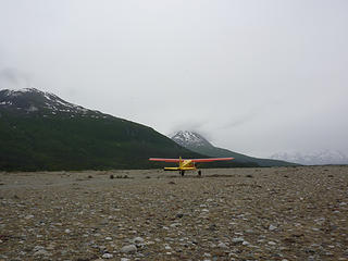 Our plane departs, hopefully to return to the same spot in 8 days, hopefully with all of us there to meet it (which we did.) 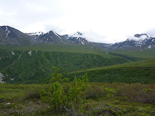 More greenery. 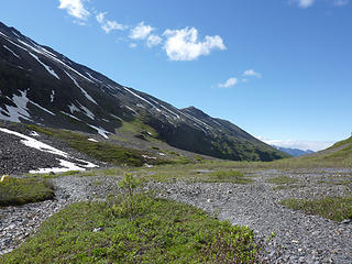 Our campsite on the 2nd night was flatter than the first night, and we had streams nearby, making for a handy water source. 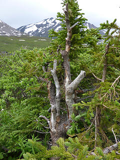 The bears have been here, scratching up against this tree, but we only saw one bear the entire trip, and it wasn't keen on getting to know us. We also saw plenty of bear scat, of both the black and brown bear variety. 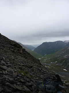 The Tana River is barely visible in the far distance. 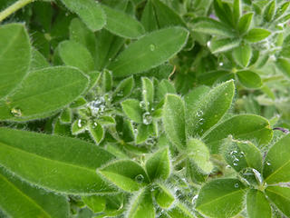 The water droplets collect on the leaves and sparkle in the light. Surface tension is a fascinating phenomenon. 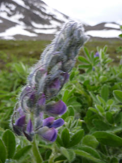 This is almost a good shot with the flower in the foreground and mountain in the background. I just wish the top of the flower was in focus. 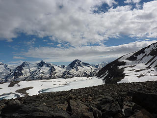 Yet More Views 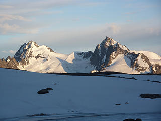 ... it's going to be hard to leave this place. Luckily, we had two nights at this campsite. 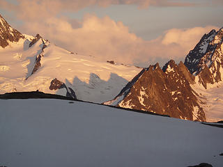 This is my favorite picture from this set. 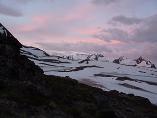 Just before 4 am, I woke up, stuck my camera out the tent, and took a few shots. 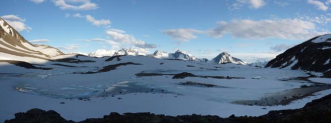 Campsite Panorama 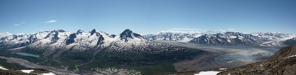 Glacier Panorama 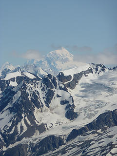 It's the 2nd highest mountain in the US (4th highest in North America) with an elevation of 18,009 feet. It's not often climbed, as it experiences severe weather. 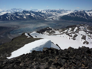 This is just one of the views from the top of the 7000 footer we climbed. 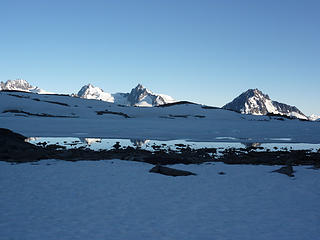 I like how you can see the reflection of multiple peaks. 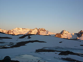 The views were crystal clear on this evening. 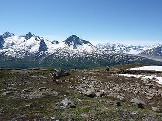 There are people in this picture. 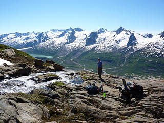 In the grand scheme of things, I don't fill much space in this world.  It was very polychromatic here. 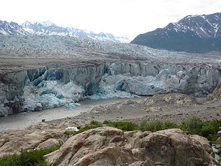 We sat here for a while, having a snack and watching the glacier calve. In the end, we hiked a bit longer so we'd have less to travel on the final day. It turned out to be a very good decision, as we barely made it to the landing spot on time. 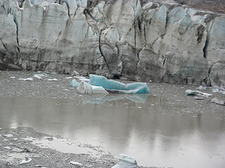 Ice Berg Reflection 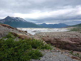 By the River 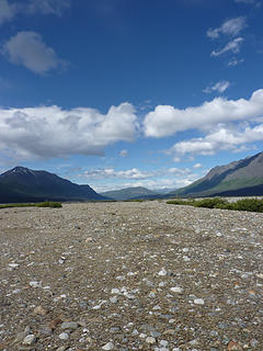 Home Stretch 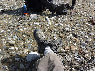 dry socks! I'd gotten my feet wet a few miles back, and my feet started to get cold while waiting for the plane. I had one last dry, clean pair of socks. Dry was essential; clean was an added bonus. 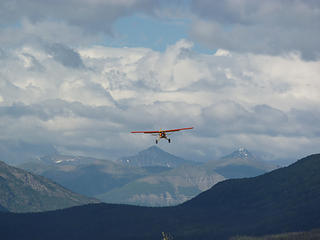 The plane's right on time. It's a good thing it came, too, as I wasn't up to putting my "Erin vs. Wild" skills to the test.
|
| Back to top |
  
|
|
Tomlike
Member

Joined: 22 Jun 2010
Posts: 407 | TRs | Pics
|
|
Tomlike
Member
|
Tue Jul 20, 2010 7:48 am |
|
|
|
| Back to top |
|
|
Foist
Sultan of Sweat

Joined: 08 May 2006
Posts: 3974 | TRs | Pics
Location: Back! |
|
Foist
Sultan of Sweat
|
Tue Jul 20, 2010 12:11 pm |
|
|
Awesome!
My wife and I are planning a 5-day fly-in trip in Wrangell-St. Elias August 10-14, specifically the Iceberg Lake valley. I hope we get some nice days in there -- you sure did! Gorgeous! I'm even more excited now.
Any advice?
|
| Back to top |
|
|
Benzarino
Member

Joined: 26 Feb 2009
Posts: 309 | TRs | Pics
Location: Bellingham |
Wow, at first I was kinda thinking the mountains didn't look all that big... And then I saw the glacier panorama photo.

|
| Back to top |
|
|
Stefan
Member

Joined: 17 Dec 2001
Posts: 5091 | TRs | Pics
|
|
Stefan
Member
|
Tue Jul 20, 2010 4:31 pm |
|
|
thanks for making me jelous. sheesh! some people have the nerve!!!
|
| Back to top |
|
|
Foist
Sultan of Sweat
Joined: 08 May 2006
Posts: 3974 | TRs | Pics
Location: Back! |
|
Foist
Sultan of Sweat
|
Tue Jul 20, 2010 4:38 pm |
|
|
Everyone should check out her full set of photos on flickr -- there are many more awesome photos and the captions are worth reading too.
|
| Back to top |
|
|
David¹
Token Canadian

Joined: 25 Jul 2002
Posts: 3040 | TRs | Pics
Location: The Great White North |
|
David¹
Token Canadian
|
Tue Jul 20, 2010 4:43 pm |
|
|
I can think of no reply that matches the awesomeness of these photos.
Eight days of hiking (return) to get to that spot where "Glacier Pano" and "Grand Scheme" were taken? You can't land anywhere closer than that? With such an expedition at stake I can't imagine the good fortune you had to get such perfect weather in such a glaciated spot. Those rivers of ice don't get there by accident.
|
| Back to top |
|
|
EJ
Member
Joined: 02 Oct 2009
Posts: 248 | TRs | Pics
|
|
EJ
Member
|
Tue Jul 20, 2010 4:44 pm |
|
|
It was an amazing place. I'd go back in heartbeat. My photography skills are lacking, so it was a bit difficult for me to capture the vastness on camera, though I tried really hard.
I got lucky with the weather. I wanted one clear day and got almost 4 days of sun and only 1 1/2 days of constant rain.
That being said, advice to Foist: bring extra dry socks, your best raingear, and a lot of plastic bags. Hopefully, you won't need them.
Where I went, there were no trails of any sort, so travel was over all sorts of terrain. A good set of collapsible trekking poles was helpful in this regard. Luckily, I didn't lose the bottom portion of one until the very last day (just slipped out of an unlocked FlickLock into the silty Tana River, never to be seen again...) I didn't find the poles useful when bushwhacking or rock scrambling, so collapsing them to put on my pack was nice.
Oh, and I did see that TR on TetonGravity, but I'd already chosen Wrangell-St. Elias as my destination. That's one impressive trip they did; I'm glad someone wrote about it because I could never do anything that crazy.
|
| Back to top |
|
|
Foist
Sultan of Sweat
Joined: 08 May 2006
Posts: 3974 | TRs | Pics
Location: Back! |
|
Foist
Sultan of Sweat
|
Tue Jul 20, 2010 4:46 pm |
|
|
Did you cross any glaciers? Also, what were the temps like?
|
| Back to top |
|
|
EJ
Member
Joined: 02 Oct 2009
Posts: 248 | TRs | Pics
|
|
EJ
Member
|
Tue Jul 20, 2010 5:46 pm |
|
|
No, no glacier crossings. It saved us a lot of weight by not having to carry glacier gear.
We basically did a big loop, starting and ending in the same place. The spot where "Grand Scheme" was taken could have been reached in a couple of days had we gone the other direction. The stellar views and weather were all at the end!
I now have my eyes on Mt. Wrangell for a ski ascent/descent. I just need to convince a friend or two that it would be an excellent adventure to share with me. 
|
| Back to top |
|
|
Matt Lemke
High on the Outdoors

Joined: 15 Jul 2010
Posts: 2052 | TRs | Pics
Location: Grand Junction |
|
Matt Lemke
High on the Outdoors
|
Thu Jul 22, 2010 12:16 am |
|
|
Excellent TR! Can't wait till I get a little older and I can be in Alaska for a summer. Is airplane travel to the area the ONLY way to get even close and if so was it pricy?
|
| Back to top |
|
|
Foist
Sultan of Sweat
Joined: 08 May 2006
Posts: 3974 | TRs | Pics
Location: Back! |
|
Foist
Sultan of Sweat
|
Thu Jul 22, 2010 5:14 am |
|
|
It's pretty pricey -- see here -- but you can drive there. There's a long dirt road to McCarthy, and there are highways around the outer edges of the park. And there are hikes you can do from the roads.
|
| Back to top |
|
|
MCaver
Founder

Joined: 14 Dec 2001
Posts: 5124 | TRs | Pics
|
|
MCaver
Founder
|
Thu Jul 22, 2010 11:06 am |
|
|
I am dying to go to Wrangell-St Elias!
|
| Back to top |
|
|
El Puma
Member

Joined: 13 Nov 2002
Posts: 341 | TRs | Pics
Location: Inside, wanting outside |
|
El Puma
Member
|
Thu Jul 22, 2010 1:09 pm |
|
|
| EJ wrote: | | I now have my eyes on Mt. Wrangell for a ski ascent/descent. |
The long North Ridge of Sanford has always called me for that...I used to drive or fly frequently between Tok and Glennallen and stop to study it with binocs...
What an adventure - thanks for sharing!
|
| Back to top |
|
|
|
|


