| Previous :: Next Topic |
| Author |
Message |
beaudaddy
Coast To Cascades


Joined: 25 Feb 2010
Posts: 401 | TRs | Pics
Location: Tulalip, WA |
|
beaudaddy
Coast To Cascades
|
 Tue Jul 27, 2010 7:16 pm |
|
|
Background-
This marks the first trip that Gimpilator and I have done together. We met on the Perry Creek Trailhead this last February for the first time. I had finished Stillaguamish Peak and he was just heading up Mt Forgotten. In meeting each other in person, we discovered that we both were members of Summitpost.org. This started off comments back and forth over photos and trip reports. The timing worked out just right and Gimpilator planned a trip for us to climb Mt Larrabee (7,861) on Sunday July 25th.
Brief Plan-
Our plan was to meet Saturday evening at the Yellow Aster Butte Trailhead. This is found just off of the Mt Baker Highway 542. Even though Gimpilators Suzuki Bandit has 1,200cc of muscle, it wouldnt be a good match for the rugged road that climbs up to Twin Lakes at (5,200). So I planned to taxi him up the last couple miles. We planned to bivy at the lakes for the night and hit the trail early Sunday morning for the southwest gully ascent to Mt Larrabee. A possible Winchester Mountain (6,521) summit was thrown into the plans for an added bonus.
Rugged, Red Larrabee has been on Gimpilators list of summits to climb for some time now. His passion for this summit has been alive far beyond our time knowing each other. I could hear the stoke in his voice just talking about this state border massive.
Day 1-
I headed up the Twin Lakes road and meet Gimplilator around 7:30pm. He parked his bike just below the Y.A.B.T.H. and piled his sweaty gear in my lifted truck. He had just spent the last night on Exelsior Peak (5,712) and then battled the sketchy summit block of Church Mountain (6,315) that afternoon. He had already made good use of the weekend so far and had stories to tell. We followed the steep road switch backing tightly until we reached the lakes. The lakes were snowed in, so we drove about 30 onto the snow until finding a great parking spot. It was about 8pm now and Gimp looked over to me and said, Lets head up Winchester Mountain real quick so we can check out our route on Larrabee for tomorrow. I wasnt sure if he was serious at first, but after seeing the mountain man in his eyes I said, Should I take my crampons?
We hoped out, threw on some gear and headed up.
 Gimpilator looking up. Mt Baker on the horizon 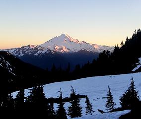 Mt Baker 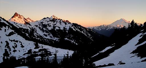 Goats, Shuksan and Baker 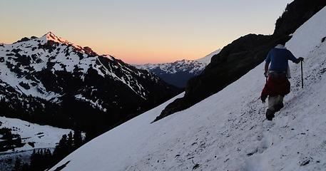 Steep snow and nice colors 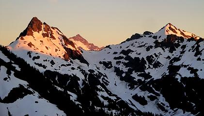 East and West Goat, with Shuksan in the middle 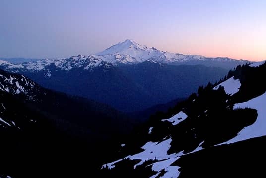 Mt Baker 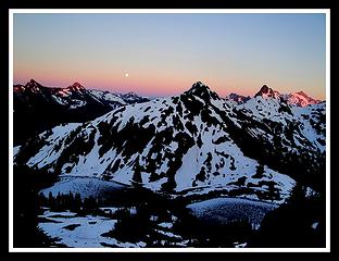 Nothing wrong with that right there 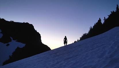 Gimpilator glowing as he looks toward the summit of Winchester 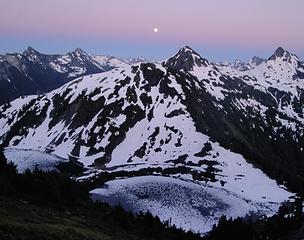 Looking South 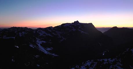 Tomyhoi Peak at sunset 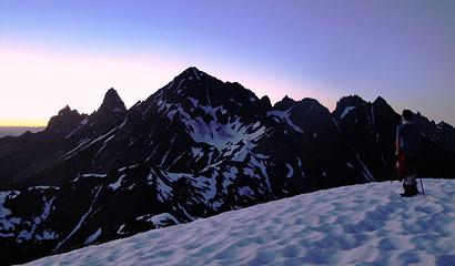 Gimp Checking out our route for the morning on Larrabee. 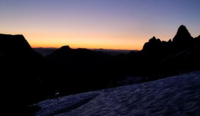 American Border Peak at dusk 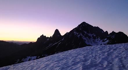 Mt Larrabee and A.B.P 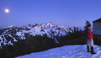 Gimpilator standing next to the Winchester Mountain lookout after sundown 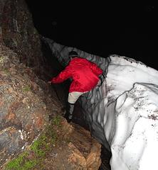 Gimp testing his ninza skills 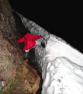 more ninja skills 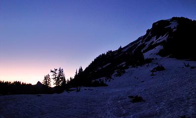 First light looking toward Pocket Peak and the Skagway Pass 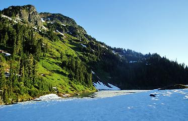 On of the Twin Lakes early in the morning 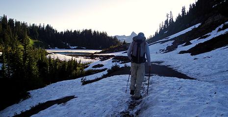 Starting out. Pocket Peak on the horizon. 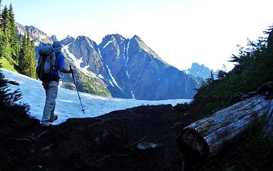 Gimpilator checking out The Pleiades 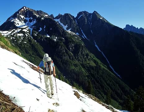 Gimpilator traversing snow. Mt Larrabee and The Pleiades on the horizon. 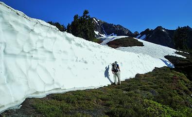 Large Headwall at Low Pass 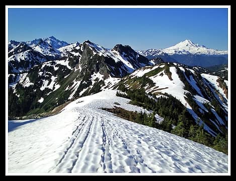 Looking south from above High Pass 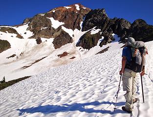 Checking out a good route 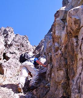 First part of the Chimney section before it became technical 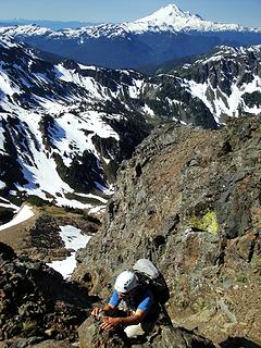 Gimp holding on high up on Larrabee 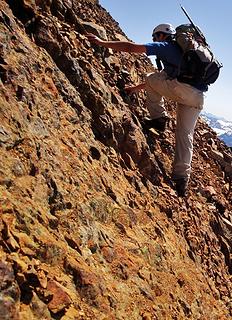 Very steep, loose rock 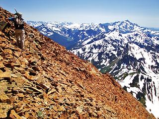 Steep, Loose Rock 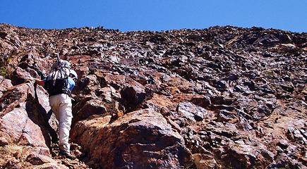 A sea of down sloping garbage 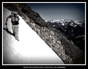 Steep Snow 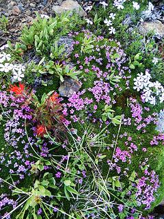 Flower Garden In The Rocks 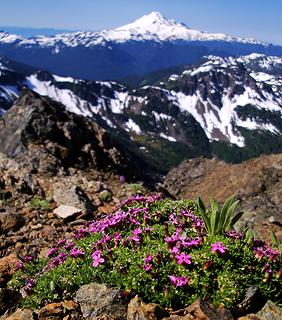 Looking out at Baker 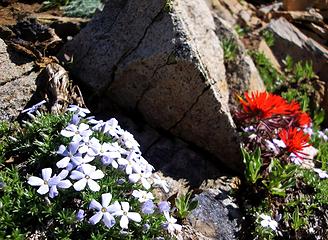 Phlox and Paintbrush 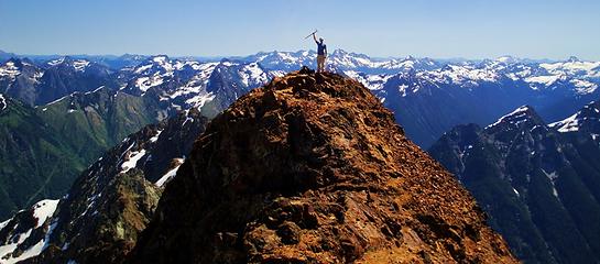 Gimpilator on the east summit 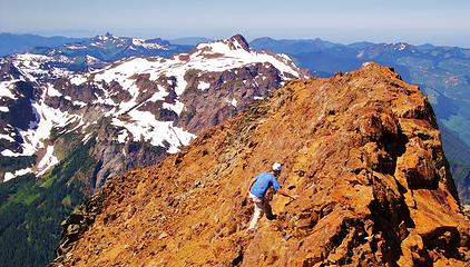 Gimpilator on the west summit with Tomyhoi Peak (7,451') 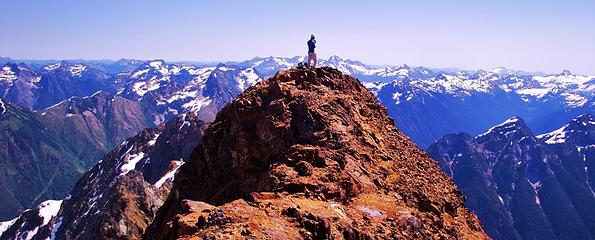 Gimpilator on the East summit 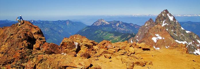 Gimpilator on the west summit. 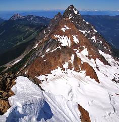 Canadian Border and American Border Peaks 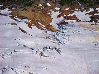 Glacier crevasses on the north side of Larrabee 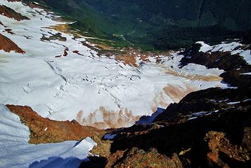 Glacier crevasses on the north side of Larrabee 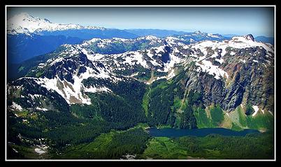 Mt Baker, Tomyhoi Lake and Peak Canadian Border and American Border Peaks 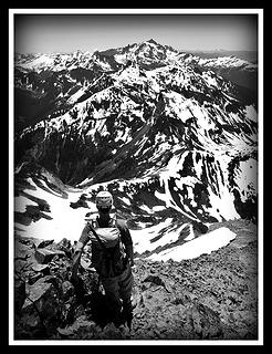 Gimpilator Checking Out Shuksan 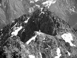 The Pleiades (7,334') 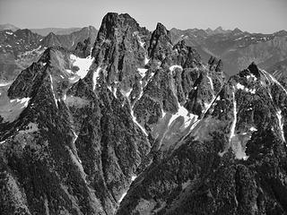 Slesse Mountain (7,850') 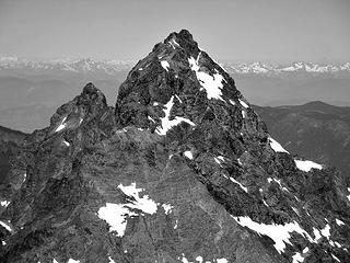 Canadian Border and American Border Peaks 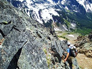 Gimpilator Down Climbing  Gimpilator down climbing the grey vein  More Down Climbing With Mt Baker 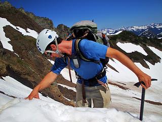 Gimp Dropping into the snow bowl 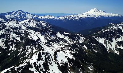 Shuksan and Baker looking south 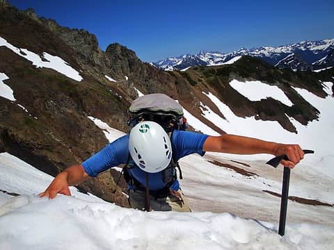 Dropping into the snow bowl 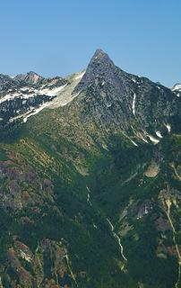 Awesome looking Pocket Peak (7,056) high above the Silesia Valley. 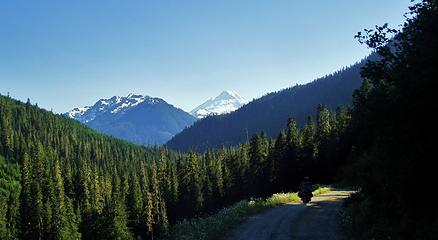 Gimpilator leading me to the killer Buffet.
|
| Back to top |
  
|
|
Gimpilator
infinity/21M

Joined: 12 Oct 2006
Posts: 1684 | TRs | Pics
Location: Edmonds, WA |
Beau, it was really a pleasure climbing with you and getting to know each other. You sure did an impressive job on the TR. Almost as good as the trip itself. Let's go for Sloan next time. What do you think?
|
| Back to top |
|
|
Magellan
Brutally Handsome

Joined: 26 Jul 2006
Posts: 13116 | TRs | Pics
Location: Inexorable descent |
|
Magellan
Brutally Handsome
|
Tue Jul 27, 2010 10:24 pm |
|
|
|
| Back to top |
|
|
beaudaddy
Coast To Cascades
Joined: 25 Feb 2010
Posts: 401 | TRs | Pics
Location: Tulalip, WA |
|
beaudaddy
Coast To Cascades
|
Wed Jul 28, 2010 11:50 am |
|
|
Adam- I would love to do Sloan later this summer. Hip waders to cross the Sauk?
Thanks Magellan. The red rock was crap, but the payoffs were spectacular. Gimp had cell service, but I didn't. I have AT&T. It would be nice to know what provider he has so others can know they can call out in case of emergency. If you have no experience or climbing skills, this climb can be very dangerous.
|
| Back to top |
|
|
Eric
Peak Geek

Joined: 21 Oct 2002
Posts: 2062 | TRs | Pics
Location: In Travel Status |
|
Eric
Peak Geek
|
Wed Jul 28, 2010 1:21 pm |
|
|
Looks like a fun time guys. A little bit of choss is good for the soul.
I've spied both Larrabee and American Border from Winchester before and someday I'll have to make the trek over to each.
|
| Back to top |
|
|
Redwic
Unlisted Free Agent

Joined: 23 Feb 2009
Posts: 3292 | TRs | Pics
Location: Going to the Prom(inence) |
|
Redwic
Unlisted Free Agent
|
Wed Jul 28, 2010 2:36 pm |
|
|
Great job, you guys! I'm sorry I was not able to make it, but my optimum timeframe to do the Skamania CoHP conflicted with the timeframe of your plans. Next time, OK?
60 pounds lighter but not 60 points brighter.
60 pounds lighter but not 60 points brighter.
|
| Back to top |
|
|
RichP
Member

Joined: 13 Jul 2006
Posts: 5633 | TRs | Pics
Location: here |
|
RichP
Member
|
Wed Jul 28, 2010 6:29 pm |
|
|
That looks like spooky stuff to climb on.
|
| Back to top |
|
|
Magellan
Brutally Handsome
Joined: 26 Jul 2006
Posts: 13116 | TRs | Pics
Location: Inexorable descent |
|
Magellan
Brutally Handsome
|
Wed Jul 28, 2010 6:52 pm |
|
|
| Quote: | | Gimpilator kept talking about this buffet in Bellingham. |
I bet you two hungry 20-something climbers made them rethink their pricing!
I forgot to mention I was glad to hear you survived the drunken redneck asshat sanity assault at one am. 
|
| Back to top |
|
|
iron
Member

Joined: 10 Aug 2008
Posts: 6392 | TRs | Pics
Location: southeast kootenays |
|
iron
Member
|
Wed Jul 28, 2010 10:07 pm |
|
|
long way to drive to shoot a gun...
how was the snow elevation on the southern slopes of nearby mountains (winchester, bump at high pass, larrabee, YAB, etc.)
|
| Back to top |
|
|
the Zachster
Member

Joined: 17 Jan 2007
Posts: 4776 | TRs | Pics
Location: dog training |
A pile of garbage indeed! Glad you had a safe and exciting trip. Beautiful photos! 
"May I always be the kind of person my dog thinks I am"
"May I always be the kind of person my dog thinks I am"
|
| Back to top |
|
|
Malachai Constant
Member

Joined: 13 Jan 2002
Posts: 16092 | TRs | Pics
Location: Back Again Like A Bad Penny |
I think I know now why Larrabee is not climbed very often 
"You do not laugh when you look at the mountains, or when you look at the sea." Lafcadio Hearn
"You do not laugh when you look at the mountains, or when you look at the sea." Lafcadio Hearn
|
| Back to top |
|
|
beaudaddy
Coast To Cascades
Joined: 25 Feb 2010
Posts: 401 | TRs | Pics
Location: Tulalip, WA |
|
beaudaddy
Coast To Cascades
|
Wed Jul 28, 2010 10:39 pm |
|
|
| iron wrote: | | long way to drive to shoot a gun...
how was the snow elevation on the southern slopes of nearby mountains (winchester, bump at high pass, larrabee, YAB, etc.) |
If you look at Gimpilators red line photo above you can see the southern face of Larrabee. That shot was taken at about 6,100' just above High Pass. Some gals were camped on the dry bump of HP. Once we climbed out of the large snow covered bowl it became dry. The only snow found were in the gully. The southwest ridge was dry. We were hoping that it had more snow because of how nasty that rock really is. In my mind I can see people turning back on that summit if they didn't find the correct route or if they weren't super eager to reach it.
Winchester had large patchy southern snowfields above 5,800'. I would guess in spots like gullys, bowls and areas that collect snow will still be around for a bit. I didn't get a good look at Yellow Aster's southern face, but I would figure it would follow the same trend. That 10' tall snow headwall at Low Pass was sure a surprise for it almost being August.
Hope that's what your looking for Iron. The photos above should give a good idea on snow elevations above 5,200' (which is the twin lakes elevation).
|
| Back to top |
|
|
beaudaddy
Coast To Cascades
Joined: 25 Feb 2010
Posts: 401 | TRs | Pics
Location: Tulalip, WA |
|
beaudaddy
Coast To Cascades
|
Wed Jul 28, 2010 10:59 pm |
|
|
|
| Back to top |
|
|
Matt
Tea, Earl Grey, Hot

Joined: 30 Jan 2007
Posts: 4307 | TRs | Pics
Location: Shoreline |
|
Matt
Tea, Earl Grey, Hot
|
Wed Jul 28, 2010 11:37 pm |
|
|
Nice trip.
Yeah, Larrabee is a loose pile of rock, but it's a fun peak when you're careful. Your photo seems to show a lot more snow than usual for this time of year.
I like your late evening ascent of Winchester with the afterglow of the sunset and the moonlight.
As beacons mountains burned at evening. J.R.R. Tolkien
As beacons mountains burned at evening. J.R.R. Tolkien
|
| Back to top |
|
|
beaudaddy
Coast To Cascades
Joined: 25 Feb 2010
Posts: 401 | TRs | Pics
Location: Tulalip, WA |
|
beaudaddy
Coast To Cascades
|
Thu Jul 29, 2010 12:40 pm |
|
|
Hey, thanks for the comment Matt. We all kind of shake our heads anout how loose that rock is up there, but all in all it was my favorite summit so far this year. 
|
| Back to top |
|
|
|
|
You cannot post new topics in this forum
You cannot reply to topics in this forum
You cannot edit your posts in this forum
You cannot delete your posts in this forum
You cannot vote in polls in this forum
|
Disclosure: As an Amazon Associate NWHikers.net earns from qualifying purchases when you use our link(s). |


 maybe they were just shooting a couple rounds of glow in the dark clay pigeons... I usually blame everything on Meth... Freaking Meth... Like the lady who attacked me this winter on barlow pass in the snow... Meth... Makes people crazy.
  Malachai Constant- even though Larrabee has hordes of epic loose rock, it's worth a trip if your ok with some exposure. Might be a better weekday peak also, for less possible climbers. The views are really some of the best around.