| Previous :: Next Topic |
| Author |
Message |
wiki summary
|
Official Sites - source of much of the information here
Mt. Baker-Snoqualmie National Forest - Alerts and Notices Road and Trail Conditions
Okanogan-Wenatchee National Forest - Current Conditions
Olympic National Forest - new Current Conditions page is now available
Olympic National Park - Current Road Conditions hotline 360-565-3131
Mt Rainier National Park - Current Road Conditions hotline 360-569-2211 press 2 then (2 for current road conditions or 3 for anticipated opening/construction projects)
Gifford Pinchot National Forest - Alerts & Notices
Washington State DOT - Mountain Passes
Naches Ranger District - Conditions
Wenatchee River Ranger District - Conditions
In general, post in alphabetical order by common road name within each section unless there are more natural geographical groupings (e.g. North Fork XXX, South Fork XXX)
Mount Rainier
Corral Pass (FS 7174) Closed since 2015 fire, campground area high severity fire with many hazardous trees.
Chinook Pass (SR 410) website
Mowich Lake Road (SR 165) Mowich Lake, Spray Park, Echo/Observation Rock
Typically opens in July
Stevens Canyon Road
Grand Park back door, Huckleberry Creek Rd 73,
Was in good condition 2023 all of the way to Lonesome Lake
I-90
Talapus (9030), Mason Lake (9031)?
Cold Creek Road (9070) to Windy Pass and PCT 7-22-2022 Drove to Mt Catherine TH in Subaru Forester. Several sections of serious potholes. Two sections with parallel gullies along the length of the road. Once the fall rains start those gullies will collect water and I suspect serious road damage will result. Joey
Tinkham (55), Good condition as of Fall 2023. May have logging traffic from Hansen Creek in 2024.
Garcia (9020) ?
Middle Fork Snoqualmie Road (FS 56) Mailbox TH, Taylor River TH, Dingford Creek TH, Goldmyer Hot Springs
05/15/23. Paved section open. Gravel section to Dingford trailhead is very rough.The Goldmyer Access Report usually has updated road conditions.
[b]North Fork Snoqualmie Road (FS 57) Bare, Dog, Goat, Phelps, ...
10/01/2014 A $75 permit is required to access Hancock Timber lands along the North Fork road. The road is public and you can drive through Hancock lands to reach FS areas for free, but you can't park and climb Fuller or visit other attractions on their land without the permit.
Rocky Run (FS 4832)
The spur (136 per Google Maps) to the backdoor TH is extra brushy but save for a nasty water channel right at the beginning and some moderate rutting about halfway in is still more or less drivable. Extra clearance would be good, don't take a car you don't want to add pinstripes to.
Teanaway
North Fork Teanaway road (9737)
Teanaway Middle Fork (NFD 113)
Jack Creek Road (9738)
Stafford Creek Road 9703
Beverly turnpike road (1391) (7.28.2021, Joey) Two bad spots washing out. We were very careful and did OK in a Subaru Forester. Low clearance might not make it.
Jungle Creek (FS 9701) Teanaway Butte, Way Creek trail, Jungle Creek trail
"Road Closed" sign at the beginning of the road.
Cle Elum Trails - road closures -
[*][b]Taneum - Manastash Area
- FSR 3350 - South Cle Elum Ridge Road
- FSR 33 - Taneum Road
- FSR 3100 - Manastash Road
- FSR 3120 near 3100 Junction. [/b]
- FSR 3100 near Buck Meadows.
- FSR 4517-117 - Granite Creek Road.
[*]Cle Elum Valley - FSR 4308 - French Cabin at 120 Junction.
[*]Cle Elum Valley Road NF-4330
[*]Swauk and Liberty FSR 9707 - Pole Patch Road - two areas - First near spur 115, the second is near 4WD319.
[*]Red Top Road
[/list]
[b]Teanaway Ridge/Jack Creek (FS 9738) ?
Mountain Loop
Mountain Loop Highway, Likely to melt out by late May 2023
Green Mtn Road (FS 41) - Tupso Pass, Three Fingers, Closed @ mile 8.6 due to damage to South Fork Canyon Creek bridge. No time line for repairs. Approx 10 miles to trail head @ Tupso Pass
FS 4110, Green Mtn., Pot holed..more like craters. 6/4/14
FS 4111, Canyon Lake, Closed at mile 0 due to wash out. 6/4/14
FS 42, Mt Pilchuck, reconstructed 2023
North Fork Sauk Road (FS 49),
4096 Bedal Creek High clearance recommended, brushed out.
Call the Darrington Ranger District at 360-436-1155 for current information
Segelsen Road (FS 18), Call the Darrington Ranger District at 360-436-1155 for current information. www.fs.usda.gov/mbs Pugh (2095), Closed (seasonal)
Straight Creek Road (FS 27), Multiple washouts
Suiattle River Road (FS 26),
Tenas Creek Road (FS 2660), Severe fire damage after bridge, expect fallen trees
Whitechuck River Road (FS 23), Washed out at mile 4, possible to bike past.
C-Post Mt Higgens access. Must park near 530 and hike in.
Highway 2 & Leavenworth
FSR #62 and roads to Persis trailhead - Gate often CLOSED. If locked in call sheriff.
Sultan Basin Road, ?
Beckler River Road (FS 65), ?
Chiwawa River Road (FS 6200) Phelps Creek TH, Spider Gap, Buck Creek Pass,
Gate at end of paved road may be closed
Icicle Creek Road (FS 7600) - Chatter Creek, 4th of July Creek, Icicle Creek, Snow Lakes In Winter, usually closed to wheeled vehicles past the 8 Mile Road junction.
Eight Mile Road (FS 7601) - Enchantments, Colchuck Lake Usually closed in winter to wheeled vehicles.
NFD 6024 - Baring Mountain Barclay Lake Road is closed indefinitely due to 2022 Bolt Creek Fire
Ranger Road (FS 7701)
6/6/20 - gate closed at bottom
North Cascades and Baker, Mt Baker Ranger District
Church Mountain (FR 3040),
Welcome Pass (FR 3060), rough
Canyon Creek (FR 31), good condition, may have logging traffic or construction over the next several years
Nooksack Road (FR 34),
Deadhorse Road (FR 37), Washed out at around mile 3,
Middle Fork Nooksack (FR 38), long with a good number of potholes
Glacier Creek (FR 39), Washed out repaired October 2023
Thompson Creek (FR 3910)
North Cascades Highway (SR 20),
Cascade River Road (FR 15), Open to Park Boundary
Sibley Creek, Hidden Lake (FR 1540), Road is rough but popular. Very bad section at last switchback barely passable to a Subaru.
Illabot Creek Road (FR 16), very brushy and narrow. Not recommended during rain events due to the landslide risk.
Mt. St. Helens
Due to a fire there is no longer a shelter at Marble Mountain Sno-Park.
Forest Road 10 2012. Closed. Mitchell Peak north access - from DNR: "While the forestland is managed by DNR, the only access road to the trailhead10 Roadcuts across private landownership, and the new landowner has gated and closed access to the road just east of the intersection with the S-1000 Road. DNR does not have a recreation easement for recreation access across this road. DNR land managers are working on a solution.In the meantime, the only access to Mitchell Peak trail is from the North Siouxon Creek Trailhead, in the southern part of the Siouxon Block. The distance from this trailhead to the top of Mitchell Peak is about 13 miles."
Olympic Peninsula
Olympic National Park - see current road conditions.
Mount Baldy, Maynard Burn, Tyler Peak - FS 2870/120, ?
Mount Ellinor, FR 24 and 2419
Mount Jupiter Road
The trail and access to the trailhead are closed through fall of 2023.
Yakima County/ Naches Ranger District
S. Fork Tieton Road 1000
wildcat 1306 road
McDaniel Lake/Buck Lake Road No. 1502
1504 road Rattlesnake
Mount Hood National Forest
Wiki summmary last edited by nilloc29 on Mon Nov 20, 2023 12:48 am (this post can be edited by any member)
Wiki summmary last edited by nilloc29 on Mon Nov 20, 2023 12:48 am (this post can be edited by any member) |
| Back to top |

|
 |
RichP
Member

Joined: 13 Jul 2006
Posts: 5634 | TRs | Pics
Location: here |
|
RichP
Member
|
 Thu Nov 19, 2015 11:06 pm |
|
|
| Quote: | | 2000 - Mt. Loop Scenic Hwy Hwy 7 County Mt. Loop Hwy Verlot
NOT CLEARED - PARTIAL CLOSURE
The Mt Loop Scenic Byway, is CLOSED at the Deer Creek Gate, approximately 12 miles east of the Verlot Public Service Center and at the Bedal Creek gate, approximately 16.5 miles south of Darrington. The closure is due to road damage, windfall trees and hazardous conditions. The gravel section of the Mt. Loop Scenic Byway is not recommended for low clearance vehicles between the end of the pavement (10 miles south of Darrington) to the Bedal Creek gate due to debris slides (rock and wood) crossing the road.For additional information go to Snohomish County road updates. No cell service for most of the drive.
Surface:Paved / County Road first 9.4 miles from Darrington, WA / Gravel next 14 miles to Barlow / Paved next 22 miles to Granite Falls, WA
Lanes:Two Lane / One Lane
Status Updated:2015-11-19 |
|
| Back to top |
 
|
|
Sky Hiker
Member

Joined: 03 Feb 2007
Posts: 1469 | TRs | Pics
Location: outside |
Any status on the Snohomish County North Fork of Skykomish/Galena road fix. Last I heard they were still going thru EIS process
|
| Back to top |
|
|
Hulksmash
Cleaning up.

Joined: 20 Apr 2008
Posts: 7113 | TRs | Pics
Location: Arlington |
|
Hulksmash
Cleaning up.
|
Mon Dec 07, 2015 2:06 pm |
|
|
Updated Wiki for Tenas Cr road 2660. Washout @ mile 4 
"Bears couldn't care less about us....we smell bad and don't taste too good. Bugs on the other hand see us as vending machines." - WetDog
Albuterol! it's the 11th essential
"Bears couldn't care less about us....we smell bad and don't taste too good. Bugs on the other hand see us as vending machines." - WetDog
Albuterol! it's the 11th essential
|
| Back to top |
|
|
treeswarper
Alleged Sockpuppet!
Joined: 25 Dec 2006
Posts: 11278 | TRs | Pics
Location: Don't move here |
|
treeswarper
Alleged Sockpuppet!
|
Fri Dec 11, 2015 3:58 pm |
|
|
Just heard that a big chunk of the 23 road is gone. It has happened
somewhere between the North Fork campground and the junction to the Cispus Center.
What's especially fun about sock puppets is that you can make each one unique and individual, so that they each have special characters. And they don't have to be humananimals and aliens are great possibilities
What's especially fun about sock puppets is that you can make each one unique and individual, so that they each have special characters. And they don't have to be humananimals and aliens are great possibilities
|
| Back to top |
|
|
yukon222
Member

Joined: 12 Mar 2007
Posts: 1893 | TRs | Pics
|
|
yukon222
Member
|
Mon Dec 14, 2015 11:50 am |
|
|
From the Ellensburg newspaper website:
TEANAWAY Two U.S. Forest Service roads in the Teanaway will be closed to the public from 5 a.m. to 5 p.m. Monday through Friday this winter for a timber harvest, according to a Forest Service news release.
The weekday closures affect Forest Service Road 9737-North Fork Teanaway and 9703-Stafford Creek. Both roads will be plowed this winter.
The roads are popular routes for snowmobilers, skiers and snowshoers, and will be open for public use in the evenings and on weekends from 5 p.m. Friday to 5 a.m. Monday. Wheeled vehicles not associated with harvest activities are not allowed on the roads at any time during the winter recreation season.
Signs will be posted in harvest areas to warn people about potential hazards, according to the release.
For more information, contact the Cle Elum Ranger Station at 509-852-1100.
|
| Back to top |
|
|
markh752
Snoozing on a rock!
Joined: 03 Dec 2011
Posts: 866 | TRs | Pics
|
|
markh752
Snoozing on a rock!
|
Tue Dec 15, 2015 6:54 am |
|
|
| treeswarper wrote: | | Just heard that a big chunk of the 23 road is gone. It has happened
somewhere between the North Fork campground and the junction to the Cispus Center. |
It looks like it will be a while before they fix the washout you mentioned. Here's a pic I saw floating around FB.
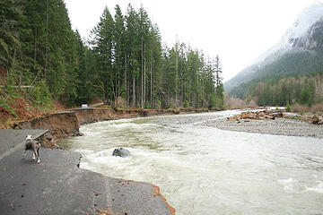 FR 23 MP 12 along Cispus River GPNF
|
| Back to top |
|
|
Sky Hiker
Member
Joined: 03 Feb 2007
Posts: 1469 | TRs | Pics
Location: outside |
NORTH FORK OF SKYKOMISH ROAD
I am the project manager assigned to this project. My contact information is listed below.
We are working to update the website and issue a newsletter soon.
Currently, the County completed a draft biological assessment (BA), and we sent it to federal agencies for their review and approval. The B.A. helps assure federal agencies and others that the project is complying with the Endangered Species Act.
The County continues to work on engineering for the proposed road project.
We expect to start construction in 2018 once the permitting is complete and we have approval from Federal Highways Administration and the Forest Service.
Larry Brewer, Engineer IV
Engineering Services - Design
|
| Back to top |
|
|
Pyrites
Member
Joined: 16 Sep 2014
Posts: 1884 | TRs | Pics
Location: South Sound |
|
Pyrites
Member
|
Fri Apr 01, 2016 12:00 am |
|
|
FS Rd 20, off US 12.
Usual set of potholes right off 12.
Dry Creek trailhead accessible.
About 1/2 mile before Smith Creek bridge a culvert is blocked, with 2' wide creek flowing across road. Passable to Subaru type vehicle? I don't know. I've never used one. Normal truck chassis vehicles can pass at creep speed. Usual disclaimers.
Edit 4/19/2016. Snow patch gone. Other comments still apply. Pyrites.
20" of snow on road at intersection to old Rd 2010. One of the old CJ's with big tires might float over. Otherwise park at 2010 intersection and hoof it maybe 3/8" mile to South Point trailhead.
PS Some ____ shot all the signs on RD 20. I have a favorite conjecture about such individuals.
Keep Calm and Carry On?
Heck No.
Stay Excited and Get Outside!
Keep Calm and Carry On?
Heck No.
Stay Excited and Get Outside!
|
| Back to top |
|
|
DIYSteve
seeking hygge

Joined: 06 Mar 2007
Posts: 12655 | TRs | Pics
Location: here now |
|
DIYSteve
seeking hygge
|
Wed Apr 20, 2016 11:45 am |
|
|
Just got the WSDOT email advising that SR20 opens Friday, details to follow
|
| Back to top |
|
|
jinx'sboy
Member
Joined: 30 Jul 2008
Posts: 931 | TRs | Pics
Location: on a great circle route |
|
| Back to top |
|
|
Kim Brown
Member
Joined: 13 Jul 2009
Posts: 6899 | TRs | Pics
|
Can you give more details on the article? Many of us don't have a paid subscription to Wenatchee World. Great newspaper though.
The USFS says road gated until the rockslide is cleared; it doesn't indicate any more damage. There has been rockslide each year at Deadhorse since the Needles fire of 2001. Perhaps it's a bigger one?
"..living on the east side of the Sierra world be ideal - except for harsher winters and the chance of apocalyptic fires burning the whole area."
Bosterson, NWHiker's marketing expert
"..living on the east side of the Sierra world be ideal - except for harsher winters and the chance of apocalyptic fires burning the whole area."
Bosterson, NWHiker's marketing expert
|
| Back to top |
|
|
jinx'sboy
Member
Joined: 30 Jul 2008
Posts: 931 | TRs | Pics
Location: on a great circle route |
Sorry...I thought the World let anyone see a couple of articles for free.
I don't know how many of these listed closures might be 'new' or not. From the May 3rd WW paper:
On the Methow Valley Ranger District: Black Canyon Road No. 4010 is damaged in several locations and will probably be closed for the summer. Also currently closed or impassible are South Fork Gold Creek Road; Benson Creek Road No. 4150; and the Harts Pass Road No. 5400, which also prevents vehicle access to Meadows Campground and Harts Pass Trailhead. Harts Pass Road will likely be closed until mid- to late-summer.
On the Wenatchee River Ranger District: A landslide at the Mission Ridge Ski & Board Resort closes public access to the mountain. Shaser Creek Road No. 7322, and White River road No. 6400 are damaged but the extent of damage is not yet known.
|
| Back to top |
|
|
MyFootHurts
Huge Member

Joined: 22 Nov 2011
Posts: 912 | TRs | Pics
Location: Kekistan |
|
| Back to top |
|
|
rubywrangler
Member

Joined: 04 Aug 2015
Posts: 511 | TRs | Pics
|
|
| Back to top |
|
|
fourteen410
Member

Joined: 23 May 2008
Posts: 2629 | TRs | Pics
|
| rubywrangler wrote: | | USFS posted on FB today that there is an impassable washout on Chiwawa River road near Atkinson Flat, 3 mi before Little Giant TH: |
Thanks - was wondering about this.
|
| Back to top |
|
|
|
|
You cannot post new topics in this forum
You cannot reply to topics in this forum
You cannot edit your posts in this forum
You cannot delete your posts in this forum
You cannot vote in polls in this forum
|
Disclosure: As an Amazon Associate NWHikers.net earns from qualifying purchases when you use our link(s). |


