| Previous :: Next Topic |
| Author |
Message |
grannyhiker
Member


Joined: 29 Jul 2006
Posts: 3519 | TRs | Pics
Location: Gateway to the Columbia Gorge |
It looks as though our OP, whose hiking experience has been confined to the Rockies and east of the Cascade Crest, has a truly new experience waiting for him: devil's club and slide alder!
My first backpack in the NW (my first since growing up in the Rockies) involved maybe 200 yards of this stuff--it was quite a shock! I never knew that such vegetation--so unfriendly and so much of it--existed outside of the Amazon jungle!
May your trails be crooked, winding, lonesome, dangerous, leading to the most amazing view.--E.Abbey
May your trails be crooked, winding, lonesome, dangerous, leading to the most amazing view.--E.Abbey
|
| Back to top |
  
|
|
Backpacker Joe
Blind Hiker

Joined: 16 Dec 2001
Posts: 23956 | TRs | Pics
Location: Cle Elum |
Its a war. You simply have to show them who's boss! Ya, sure buddy! 
"If destruction be our lot we must ourselves be its author and finisher. As a nation of freemen we must live through all time or die by suicide."
Abraham Lincoln
"If destruction be our lot we must ourselves be its author and finisher. As a nation of freemen we must live through all time or die by suicide."
Abraham Lincoln
|
| Back to top |
|
|
Joey
verrry senior member

Joined: 05 Jun 2005
Posts: 2799 | TRs | Pics
Location: Redmond |
|
Joey
verrry senior member
|
 Mon Aug 30, 2010 8:43 pm |
|
|
At first I thought I would do the OP an enormous favor by not posting this info. Certainly I have no wish to foster irrational enthusiasm in the mind of any intrepid explorer. But upon further reflection I decided that just maybe there might possibly be ever-so-faint-and-infrequent tiny traces of some seldom-traveled and long-forgotten trail from Barclay Lake to Jacks Pass if one had an idea of where to look. It even had a number: 1055.2
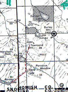 Long lost trail  Ancient trail (?) Barclay to Jacks Pass
|
| Back to top |
|
|
Hulksmash
Cleaning up.

Joined: 20 Apr 2008
Posts: 7113 | TRs | Pics
Location: Arlington |
|
Hulksmash
Cleaning up.
|
Mon Aug 30, 2010 11:55 pm |
|
|
Joey....you just gave me yet another reason to just wander around back there with no particular destination in mind. Ya just never know what might be back there. 
"Bears couldn't care less about us....we smell bad and don't taste too good. Bugs on the other hand see us as vending machines." - WetDog
Albuterol! it's the 11th essential
"Bears couldn't care less about us....we smell bad and don't taste too good. Bugs on the other hand see us as vending machines." - WetDog
Albuterol! it's the 11th essential
|
| Back to top |
|
|
Mountain Mojo
Member

Joined: 27 Aug 2010
Posts: 23 | TRs | Pics
|
For those who have climbed to the top of the saddle from Eagle lake,...how long did it take? The arial photo seems to show a path on both sides. In this type of ground i would normally try to skirt the edges of the treelines to make better progress, but its hard to tell which route would be better. On the left there is a very distinguishable tree line bordered by brush, and the talus slope (Merchant Peak Side). It seems that it may be the better route as opposed to climbing the right side through the thicker tree stands. However, there is a narrower clear portion on the right, but the trees get thick about halfway up. Thoughts?
I am determined to go in from Barclay and over the ridge at Eagle to Simms.......it could certainly cost me my pride should i fail to get to get there in a day, but if I don't try, I won't know. The more I here folks saying how hard it will be, the more i want to try it..... I am not necessarily looking for the easiest way in. However, if the going is that rough, we may have to shoot for Simms on day 1, and then make Sunset the Saturday day hike from Simms? Probably easier to pack out Sunday if we camp at Simms anyway.
control your destiny, or someone else will!
control your destiny, or someone else will!
|
| Back to top |
|
|
Sky Hiker
Member

Joined: 03 Feb 2007
Posts: 1469 | TRs | Pics
Location: outside |
Is there a reason why you are determined to go to Simms and Sunset? There are better lakes to go to. You can expect a long day if you go from Barclay but like you said your mind is set. I wish you luck.
|
| Back to top |
|
|
Hulksmash
Cleaning up.
Joined: 20 Apr 2008
Posts: 7113 | TRs | Pics
Location: Arlington |
|
Hulksmash
Cleaning up.
|
Tue Aug 31, 2010 8:29 am |
|
|
You are correct..it is easier to skirt Eagle lake on the Merchant Side.  Here's some more detailed photo's than the Sat images. Only the edge of the saddle is visible.
This of course is Merchant.
This is looking back at Eagle from a vantage point on Merchant.
And this is peaking over that Saddle from Townsend.
Hope there helpful.
I'm really rooting for you. But i'm afraid you not going to make it in a day. So be prepared to swallow your pride.
Here's some more detailed photo's than the Sat images. Only the edge of the saddle is visible.
This of course is Merchant.
This is looking back at Eagle from a vantage point on Merchant.
And this is peaking over that Saddle from Townsend.
Hope there helpful.
I'm really rooting for you. But i'm afraid you not going to make it in a day. So be prepared to swallow your pride. 
"Bears couldn't care less about us....we smell bad and don't taste too good. Bugs on the other hand see us as vending machines." - WetDog
Albuterol! it's the 11th essential
"Bears couldn't care less about us....we smell bad and don't taste too good. Bugs on the other hand see us as vending machines." - WetDog
Albuterol! it's the 11th essential
|
| Back to top |
|
|
Mountain Mojo
Member
Joined: 27 Aug 2010
Posts: 23 | TRs | Pics
|
Yes, pics help. Not as steep on the left as i had envisioned which is good.
Did you go to Eagle from Barclay? If so how long did it take you to get from the Barclay Trail Head to the Merchant/Townsend Ridge above Eagle? We dont plan on making our first stop until Stone Lake.
control your destiny, or someone else will!
control your destiny, or someone else will!
|
| Back to top |
|
|
Scrooge
Famous Grouse

Joined: 16 Dec 2001
Posts: 6966 | TRs | Pics
Location: wishful thinking |
|
Scrooge
Famous Grouse
|
Tue Aug 31, 2010 8:48 am |
|
|
Devil's club is innocuous compared to salmonberry and blackberry, and your machete will just stir them around. Picture a thicket of brambles woven through a tangle of blowdown covering a pile of talus. Your maps and aerial photos just don't tell the story, MM. I think Grannyhiker had the right of it.
| Quote: | | It looks as though our OP, whose hiking experience has been confined to the Rockies and east of the Cascade Crest, has a truly new experience waiting for him: |
Like the other posters, I've spent some hours in the brush in that area ....... but I wish you luck, anyway.
Incidentally, MM, the route from Barclay to Eagle is entirely on a trail, so adding that to your trip doesn't prove anything.
Something lost behind the ranges. Lost and waiting for you....... Go and find it. Go!
Something lost behind the ranges. Lost and waiting for you....... Go and find it. Go!
|
| Back to top |
|
|
Hulksmash
Cleaning up.
Joined: 20 Apr 2008
Posts: 7113 | TRs | Pics
Location: Arlington |
|
Hulksmash
Cleaning up.
|
Tue Aug 31, 2010 8:58 am Re: Sunset/simms
|
|
|
| Mountain Mojo wrote: | | Yes, pics help. Not as steep on the left as i had envisioned which is good.
Did you go to Eagle from Barclay? If so how long did it take you to get from the Barclay Trail Head to the Merchant/Townsend Ridge above Eagle? We dont plan on making our first stop until Stone Lake. |
I have never gone to Eagle from Barclay. I don't understand why any one would want too, Scramble something like 1000 feet in a half mile off trail, when you can simply take the maintained trail which one way equivalent of a round trip to Big 4 in terms of elevation gain and distance. 
"Bears couldn't care less about us....we smell bad and don't taste too good. Bugs on the other hand see us as vending machines." - WetDog
Albuterol! it's the 11th essential
"Bears couldn't care less about us....we smell bad and don't taste too good. Bugs on the other hand see us as vending machines." - WetDog
Albuterol! it's the 11th essential
|
| Back to top |
|
|
Mountain Mojo
Member
Joined: 27 Aug 2010
Posts: 23 | TRs | Pics
|
I have been into Barcly a number of times in the past. Once in the winter (cold and snowy). Each time i wanted to continue, but it was always early winter/early spring so packing into Eagle was even a trek and Simms was not in the cards. In the summer I went as far as Stone lake, but it was a late start and a day hike, so i went back out. I have always wanted to see how far i could get going the Barclay route.
I knew Simms and Sunset were there and that lots of folks go to Eagle (even little kids), so i just got focused on getting to Simms/Sunset. I have yet to here a story of a 6 year old at Simms or Sunset but plenty of those stories about Eagle. Getting to Eagle is an easy hike in my book if a 6 year old can do it! I figured the end of summer would be best as the snow would be essentially gone (except for maybe the highest points). And trekkers would have blazed slightly more noticeable trails through the spring and summer to make the Eagle trip a breeze.
So when I get to Eagle, the lure of Simms will be to great for me not to try to get there. Doing it in a day is the "challenge" part. I have no doubt I could make Sunset in two days regardless of the "devils Club and Alder Slide" everyone talks about. I think any average hiker can do it in two days. So, the challenge i have set for myself is to get as far in as i can in about 8 or 9 hours (i want to set up camp in daylight).
I appreciate the encouragement, and i will have all my new NWHiker buddy's on my mind as i am slowly hacking my way through some backside slope with Devils Club thorns in my forehead 
control your destiny, or someone else will!
control your destiny, or someone else will!
|
| Back to top |
|
|
Mountain Mojo
Member
Joined: 27 Aug 2010
Posts: 23 | TRs | Pics
|
BTW...as I said before I am a hunter, and I have lived in Washington almost my entire life. I have hunted in the Olympics in the past so I know how thick and nasty the undergrowth can get  Its also one of the reasons i rarely go hunting on the west side anymore Its also one of the reasons i rarely go hunting on the west side anymore 
control your destiny, or someone else will!
control your destiny, or someone else will!
|
| Back to top |
|
|
Hulksmash
Cleaning up.
Joined: 20 Apr 2008
Posts: 7113 | TRs | Pics
Location: Arlington |
|
Hulksmash
Cleaning up.
|
Tue Aug 31, 2010 9:07 am |
|
|
I don't think the 6 year old got to Eagle via Barclay.
"Bears couldn't care less about us....we smell bad and don't taste too good. Bugs on the other hand see us as vending machines." - WetDog
Albuterol! it's the 11th essential
"Bears couldn't care less about us....we smell bad and don't taste too good. Bugs on the other hand see us as vending machines." - WetDog
Albuterol! it's the 11th essential
|
| Back to top |
|
|
Mountain Mojo
Member
Joined: 27 Aug 2010
Posts: 23 | TRs | Pics
|
control your destiny, or someone else will!
|
| Back to top |
|
|
Sky Hiker
Member
Joined: 03 Feb 2007
Posts: 1469 | TRs | Pics
Location: outside |
Well then why not make it interesting and go right up to the top of Townsend and down the other side to Simms. You might as well go to 4th of July lake while you are there you can even go down 4th of July creek which is choked with vine maple and slide alder.  Wait go up there in the rain this will make a real impression on you. Wait go up there in the rain this will make a real impression on you.
|
| Back to top |
|
|
|
|


