| Previous :: Next Topic |
| Author |
Message |
lopper
off-route


Joined: 22 Jan 2002
Posts: 845 | TRs | Pics
|
|
lopper
off-route
|
 Tue Aug 31, 2010 10:59 pm |
|
|
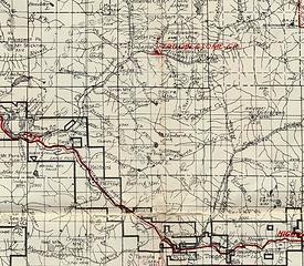
From the 1935 Snoqualmie Nat'l Forest Map -- F.A. Silcox Forester
Sunset Lk was depicted as Howard Lake. (odd, since it doesn't drain into Howard Creek)
A trail is shown to the lake via the Trout Creek drainage.
Nothing is shown going over the hill from Eagle.
Aldo Leopold quote:
"Of what avail are forty freedoms without a blank spot on the map?"
Best of luck on your quest.
 HowardLk
|
| Back to top |
  
|
|
Hulksmash
Cleaning up.

Joined: 20 Apr 2008
Posts: 7113 | TRs | Pics
Location: Arlington |
|
Hulksmash
Cleaning up.
|
Wed Sep 01, 2010 12:20 am |
|
|
A trail up Trout Creek to Sunset lake makes sense. Why wouldn't there be considering the lake was had a dam, and a wooden pen stock pipe was run all the way from Sunset Lake to the Sunset mine. Problem is all that remains is some random rusty iron spirals in the woods, and an occasional stone pile used to support the pipe. Of course not many traces of trail.
Here's one. This is laying in the brush below Merchant peak near Trout Creek.
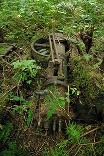 artifact  There is no trace of any road, or trail any where near it. Almost as if it fell out of the sky. I know better. Had to have been hauled in by mule team. There is no trace of any road, or trail any where near it. Almost as if it fell out of the sky. I know better. Had to have been hauled in by mule team.
"Bears couldn't care less about us....we smell bad and don't taste too good. Bugs on the other hand see us as vending machines." - WetDog
Albuterol! it's the 11th essential
"Bears couldn't care less about us....we smell bad and don't taste too good. Bugs on the other hand see us as vending machines." - WetDog
Albuterol! it's the 11th essential
|
| Back to top |
|
|
Sky Hiker
Member

Joined: 03 Feb 2007
Posts: 1469 | TRs | Pics
Location: outside |
Prepare for crummy weather if you are not going in until Sept 24th. That time of the year that backside of Townsend never dries out so an extra change of clothes is a good idea. 3/4 of Simms is surrounded by huckleberry brush so the best spot to hang out at is the outlet. this where you will find the plaque.
|
| Back to top |
|
|
Joey
verrry senior member

Joined: 05 Jun 2005
Posts: 2797 | TRs | Pics
Location: Redmond |
|
Joey
verrry senior member
|
Wed Sep 01, 2010 5:49 am |
|
|
This thread is begging for a current topo map.
To see the map full screen click Actions ==> Full screen
To see the aerial with labels click MyTopo ==> Hybrid
View larger size in new window
|
| Back to top |
|
|
Sky Hiker
Member
Joined: 03 Feb 2007
Posts: 1469 | TRs | Pics
Location: outside |
|
| Back to top |
|
|
Mountain Mojo
Member

Joined: 27 Aug 2010
Posts: 23 | TRs | Pics
|
Looks like the thread on this one is still going! Great! We need to get a good topo of the area (not from the internet) what is the map section?
And, yes, we are expecting the very good possibility that we will have rain, We are prepared for that.
control your destiny, or someone else will!
control your destiny, or someone else will!
|
| Back to top |
|
|
Joey
verrry senior member
Joined: 05 Jun 2005
Posts: 2797 | TRs | Pics
Location: Redmond |
|
Joey
verrry senior member
|
Sat Sep 04, 2010 5:17 pm Re: Map
|
|
|
| Mountain Mojo wrote: | | Looks like the thread on this one is still going! Great! We need to get a good topo of the area (not from the internet) what is the map section? |

|
| Back to top |
|
|
Mountain Mojo
Member
Joined: 27 Aug 2010
Posts: 23 | TRs | Pics
|
What are the opinions concerning the best place to get a good topo map of this area? I dont have a physical paper map in my hands yet.... i will want one, of course, before we head up.
control your destiny, or someone else will!
control your destiny, or someone else will!
|
| Back to top |
|
|
Tom
Admin
Joined: 15 Dec 2001
Posts: 17851 | TRs | Pics
|
|
Tom
Admin
|
Sun Sep 05, 2010 1:16 pm |
|
|
Can't you see the topo map Joey posted? That is the 24K USGS quad which is pretty much the best thing out there for navigating off trail in the cascades. Just print it, or click on the mytopo.com link to order one printed.
|
| Back to top |
|
|
Backpacker Joe
Blind Hiker

Joined: 16 Dec 2001
Posts: 23956 | TRs | Pics
Location: Cle Elum |
That or visit an REI and use their custom map machine. You can orient the map exactly how you want it and then print it there. 9.95 each.
Issaquah REI doesnt have a map machine.... Dang it.
"If destruction be our lot we must ourselves be its author and finisher. As a nation of freemen we must live through all time or die by suicide."
Abraham Lincoln
"If destruction be our lot we must ourselves be its author and finisher. As a nation of freemen we must live through all time or die by suicide."
Abraham Lincoln
|
| Back to top |
|
|
Anna Mae
or may not

Joined: 18 Feb 2004
Posts: 239 | TRs | Pics
Location: vacillating |
|
Anna Mae
or may not
|
Sun Sep 05, 2010 3:12 pm |
|
|
BPJ's got a point. If you go someplace like Metsker Maps in downtown Seattle, you'll need four USGS topo maps to plan your route and see what your options are.
Anna Mae
Against stupidity ...... the gods themselves ...... contend in vain.
Against stupidity ...... the gods themselves ...... contend in vain.
|
| Back to top |
|
|
Joey
verrry senior member
Joined: 05 Jun 2005
Posts: 2797 | TRs | Pics
Location: Redmond |
|
Joey
verrry senior member
|
Sun Sep 05, 2010 5:05 pm |
|
|
| Tom wrote: | | Can't you see the topo map Joey posted? That is the 24K USGS quad which is pretty much the best thing out there for navigating off trail in the cascades. Just print it, or click on the mytopo.com link to order one printed. |
I highly recommend ordering a waterproof MyTopo paper map with the UTM grid. I assume you have a ranger compass (or similar) with the 1:24,000 UTM grid printed on the baseplate. That, plus a mechanical altimeter will be a huge navigational aid when your GPS craps out or cannot get a decent signal since so much of the sky is blocked by the super-steep terrain.
With a bit of work you could generate a GPS file with rough approximate waypoints for the non-existent trail on the Fireplan map snip I posted. You can have that data added to your MyTopo map when you order it.
|
| Back to top |
|
|
Mountain Mojo
Member
Joined: 27 Aug 2010
Posts: 23 | TRs | Pics
|
LOL ... i just breezed over the map post, didn't realize it was an interactive map from the forum .... i now have the topo maps i need....i just imported it all to a file and printed a couple different ones out on matt finish photo paper and laminated them.....
control your destiny, or someone else will!
control your destiny, or someone else will!
|
| Back to top |
|
|
Mountain Mojo
Member
Joined: 27 Aug 2010
Posts: 23 | TRs | Pics
|
Just a quik update. We lost 3 party members (Work and injury) so we have posponed the Sunset Lake Hike till next year. However. The two of us that remained still wanted to hike so we went to Pete lake out near Roslyn. Pretty easy hike, but certainly gorgeous this time of year. only 3 hours to get to the lake from the trailhead and little elevation, so more of a beginner hike  . I'll post some pics later. . I'll post some pics later.
control your destiny, or someone else will!
control your destiny, or someone else will!
|
| Back to top |
|
|
Sky Hiker
Member
Joined: 03 Feb 2007
Posts: 1469 | TRs | Pics
Location: outside |
Yea a smart idea to wait until next summer!! That way you can plan a little better.
|
| Back to top |
|
|
|
|


