| Previous :: Next Topic |
| Author |
Message |
Tyler
Member


Joined: 06 Jun 2003
Posts: 61 | TRs | Pics
Location: Monroe |
|
Tyler
Member
|
 Sun Sep 12, 2010 1:52 pm |
|
|
Looks like the DNR got bored and pulled all of the culverts on the old road that follows Olney creek. I counted sixteen new tank traps on the lower section of road after the monster mud puddles. They threw in a debris barricade for good measure.
|
| Back to top |
  
|
|
GeoHiker
Rocky Walker
Joined: 26 Feb 2005
Posts: 6033 | TRs | Pics
Location: Off the Deep End |
|
GeoHiker
Rocky Walker
|
Wed Sep 15, 2010 2:28 pm |
|
|
The evil bastards! Like they had to go in there again and mess that road up even more? So how far in can you go?
You call some place paradise, kiss it goodbye......Eagles
You call some place paradise, kiss it goodbye......Eagles
|
| Back to top |
|
|
Tyler
Member
Joined: 06 Jun 2003
Posts: 61 | TRs | Pics
Location: Monroe |
|
Tyler
Member
|
Wed Sep 15, 2010 7:56 pm |
|
|
You can get about a 1/4 mile past the big puddles if you have a capable rig before you hit the barricade.
Some of the new gulleys are quite deep with flowing water cutting them deeper. It's only going to get worse.
|
| Back to top |
|
|
Backpacker Joe
Blind Hiker

Joined: 16 Dec 2001
Posts: 23956 | TRs | Pics
Location: Cle Elum |
What about a motorcycle?
"If destruction be our lot we must ourselves be its author and finisher. As a nation of freemen we must live through all time or die by suicide."
Abraham Lincoln
"If destruction be our lot we must ourselves be its author and finisher. As a nation of freemen we must live through all time or die by suicide."
Abraham Lincoln
|
| Back to top |
|
|
Magellan
Brutally Handsome

Joined: 26 Jul 2006
Posts: 13116 | TRs | Pics
Location: Inexorable descent |
|
Magellan
Brutally Handsome
|
Wed Sep 15, 2010 9:26 pm |
|
|
|
| Back to top |
|
|
Schroder
Member

Joined: 26 Oct 2007
Posts: 6719 | TRs | Pics
Location: on the beach |
|
Schroder
Member
|
Wed Sep 15, 2010 10:41 pm |
|
|
Here's from a post I did earlier this year. It gets more difficult as time goes by to get back there & I think PUD & DNR would rather we just forgot about it.
--------
With the current state of roads, the shortest way up Mt Stickney is the old route up from the Kromona Mine Road.
via Greg Ball & Wallace Lake:
Trail 3.18 1636 258 (miles/ft gain/ft loss)
Good Road 4.52 1906 228
Bad Road & trail 2.61 1901 140
total 10.31 5443 626
via Kellogg Lake Rd & Wallace Lake:
Good Road 8.51 3250 340
Bad Road & trail 2.61 1901 140
total 11.12 5151 480
via Olney Creek:
Old Road 4.03 1984 93
Trail 1.78 1753 68
total 5.81 3737 161
via Kromona Mine Road:
Old Road 2.22 327 216
Trail 3.26 3310 225
total 5.48 3637 441
|
| Back to top |
|
|
Mike Collins
Member
Joined: 18 Dec 2001
Posts: 3096 | TRs | Pics
|
| Backpacker Joe wrote: | | What about a motorcycle? |
A motorcycle with a snorkle could make it happen.
|
| Back to top |
|
|
Scrooge
Famous Grouse

Joined: 16 Dec 2001
Posts: 6966 | TRs | Pics
Location: wishful thinking |
|
Scrooge
Famous Grouse
|
Thu Sep 16, 2010 6:29 am |
|
|
Schroder said | Quote: | | With the current state of roads, the shortest way up Mt Stickney is the old route up from the Kromona Mine Road |
The route via the Kromona Mine Road may be the shortest, but I question whether it's the easiest. That ought still to be the route via the Olney Creek Road (in spite of the tank-trap puddles). Unless it's become heavily overgrown since Larch and I were up there, it's got to be much easier walking then any semblance of a 'trail' through the talus fields of Kromona basin.
Also, for what it's worth, the Olney Creek Road actually goes almost two miles further that what's shown on the USGS map. In fact, it curves around till it intersects that trail from Kromona mine, if by some chance the part of the route that's left is preferable to the Olney Creek route.
I've taken the liberty of adding the approximate course of that Olney Creek Road extension to your map.
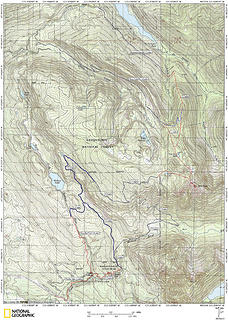 stickney4.1
Something lost behind the ranges. Lost and waiting for you....... Go and find it. Go!
Something lost behind the ranges. Lost and waiting for you....... Go and find it. Go!
|
| Back to top |
|
|
Schroder
Member
Joined: 26 Oct 2007
Posts: 6719 | TRs | Pics
Location: on the beach |
|
Schroder
Member
|
Thu Sep 16, 2010 7:03 am |
|
|
That north route didn't go through any talus. It was all heavy timber until they logged it in 1987. It's probably brushy now. You ran into the talus field if you started a couple of miles further up the road toward the mine.
There was another trail I didn't show that came off the high logging spur to the north of the Olney creek road, on the north side of that hill, and intersected at the little pass.
|
| Back to top |
|
|
Sultan Guy
Member

Joined: 22 Jul 2008
Posts: 353 | TRs | Pics
Location: Now reinforced with Concrete |
Tyler-thanks for that bit of information. Over the summer I noticed that the DNr had put some of the large machinery they were using to pull culverts out of the South Shore Road onto the Olney Creek Road.
I had not yet walked up that road to see what they did.
The Olney Creek Road was pretty popular with the ORV crowd and since it was not in the Spada watershed neither the PUD or City of Everett really minded the traffic.
My guess is that the DNR took these latest measures to comply with the change in management status to the new Morning Star NRCA.
Any worthwhile expedition can be planned on the back of an envelope- H. W. Tilman
Any worthwhile expedition can be planned on the back of an envelope- H. W. Tilman
|
| Back to top |
|
|
maurella
Member

Joined: 15 Apr 2005
Posts: 31 | TRs | Pics
Location: Snohomish, WA |
|
maurella
Member
|
Mon Jun 27, 2011 12:01 am |
|
|
While I think this might be a bummer for someone who wants to drive in as far as posible, this Olney route looks to me to be a good combination mountain bike/hike trip. I went up Stickney in May 2009, and it looked to me like it would a reasonable mountain bike hike up to the point that Schroeder penned in his route off the old road. Note that, for me, I'm not going to bike all the way there; I'll walk it much of the way, but coming out more than makes up for the effort walking the thing up.
I'm curious if anyone has been up this way this year as I am thinking of trying it the weekend of the 4th.
|
| Back to top |
|
|
Ice Girl 2
Member
Joined: 19 Jun 2011
Posts: 7 | TRs | Pics
|
For bikes or walking the road that goes up Stickney, starting just after the switch backs on the Sultan Basin road is beyond terriable, Todd and I just recently hikes most of the road. With the snow on it it was worse, it is doable but there is some pretty steep ones in there further.
We plan on going back either way, it would be easier if they weren't there. The mud hole at the beginning were easy.
Ice Girl
|
| Back to top |
|
|
Scrooge
Famous Grouse

Joined: 16 Dec 2001
Posts: 6966 | TRs | Pics
Location: wishful thinking |
|
Scrooge
Famous Grouse
|
Mon Jun 27, 2011 4:42 pm |
|
|
Just walk it. Park your car on the Olney Creek Road and walk in. Even 10 years ago, when we surveyed it for "Roads to Trails", you could only drive it about a mile (in a big, high clearance truck), to the first uphill switchback. There you had Jersey barriers, trenches and berms, all the way up the steep section between the two switchbacks.
After that, you had more than 80 trenches in the next mile (I counted 'em). They weren't too bad, for hiking, but biking would be far more trouble than it was worth.
For that matter, you can't take a bike through the 'lakes', and getting around them is hard, even on foot.
Walk it. It's still the best approach to Stickney.
Something lost behind the ranges. Lost and waiting for you....... Go and find it. Go!
Something lost behind the ranges. Lost and waiting for you....... Go and find it. Go!
|
| Back to top |
|
|
cartman
Member
Joined: 20 Feb 2007
Posts: 2800 | TRs | Pics
Location: Fremont |
|
cartman
Member
|
Tue Jun 28, 2011 7:49 am |
|
|
| Mike Collins wrote: | | A motorcycle with a snorkle could make it happen. |
That would be a submersicycle.
|
| Back to top |
|
|
KurgansDad
Member
Joined: 03 Apr 2015
Posts: 23 | TRs | Pics
|
Just to update this thread: The old logging roads on the south side are now rebuilt and active. It's a steep slog for 4+ miles above Wallace Lake. The high point is 1500 yds S of Cecelia Lake, which itself is a tough bushwhack along to old now non-existent road.
From that high point, a short 500 yd bushwack bearing roughly SE back to the western end of the marshy high basin/valley above Lake Stickney. So much fun exploring up there. You will get wet feet even in late August.
That basin, is about 2600 yds across to the eastern end. From there, continue east 600-700 yds and up 400 ft or so to Rose Lake.
Another 400 yds east and then scramble (loose dirt/needles) up the saddle to the northwest of Mt Stickney.
Then it gets dicey. Not exposed, just hard route finding traversing around West Stickney.
I've not completed that quest. I ran out of time at that point on 2 separate trips (going up Olney Creek side then camping at Lake Stickney, then up to the basin, Rose Lake etc)
That saddle is basically 500 ft above One Acre Lake, and at this point, I had to veggie belay down and head down to make it home in time for other commitments.
For too many years I gazed at the Cascades and other mountains as they taunted me and I said "...Someday..." Now I find I'm running out of somedays...
For too many years I gazed at the Cascades and other mountains as they taunted me and I said "...Someday..." Now I find I'm running out of somedays...
|
| Back to top |
|
|
|
|


