| Previous :: Next Topic |
| Author |
Message |
beaudaddy
Coast To Cascades


Joined: 25 Feb 2010
Posts: 401 | TRs | Pics
Location: Tulalip, WA |
|
beaudaddy
Coast To Cascades
|
 Wed Sep 29, 2010 1:57 pm |
|
|
I posted a report on this mountain a couple weeks ago. This is however a New trip. I submitted a trip report on summitpost, but I thought I would also share my adventure here. I have also noticed that there is not alot to be found for the particular mountain on this site.
Just some of my thoughts
I'm always caught with amazement on how the mountains can be so surprisingly unpredictable. Generally speaking, the experience is never the same. This one attribute can prove to be good, but sometimes this can be a bad thing. Nevertheless, this is what keeps me coming back. This sweet mystery in knowing that I might experience something new, something fresh, something that will change me and something that I will never forget. But is it really the mountains that are surprisingly different or maybe its the journey thats always keeping me at the epics edge?
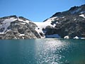
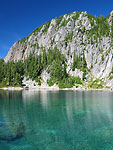
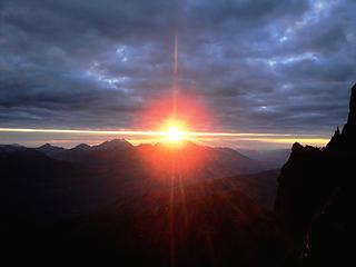 The Goodness Being Squeezed Out Of The Sun... 9.22.10 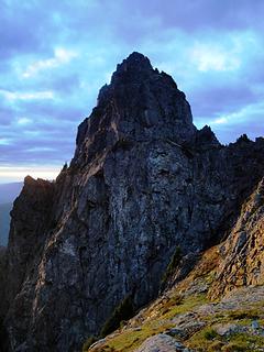 A Striking Sub Peak Of Sorts... 9.22.10 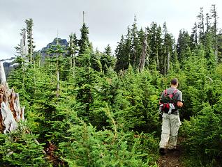 Starting Out Through Dense Evergreens 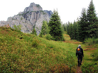 Here I'm heading up the trail. The north sub peak of White Chuck is visible here... Photo By Gimp 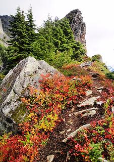 Colorful Ridge 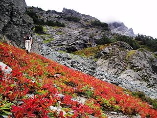 Blueberry Meadows 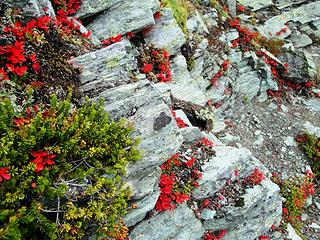 Colors Amongst The Rocks 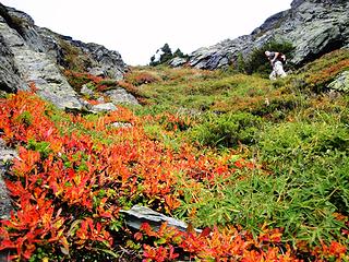 Gimpilator enjoying the fall colors 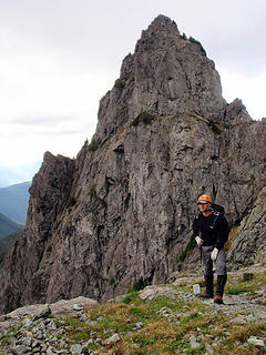 Coming out of the gully you get a great view of the sub peak... Photo By Gimp 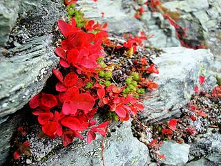 Blueberry Leaves up Close 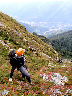 Steep heather slopes with the White Chuck River 5,000' below... Photo By Gimp 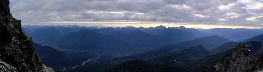 Panorama Looking West 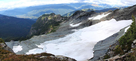 Looking down at the Glacier... Photo By Gimp 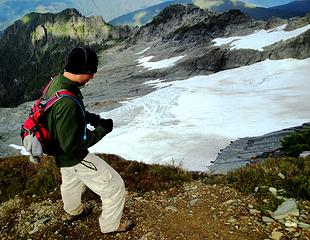 Whitechuck Glacier 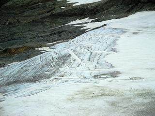 Whitechuck Glacier 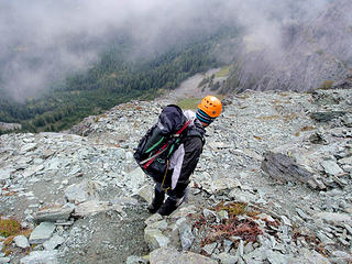 Loose Rock Exposure... Photo By Gimp 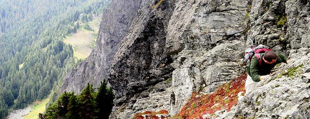 The Crux 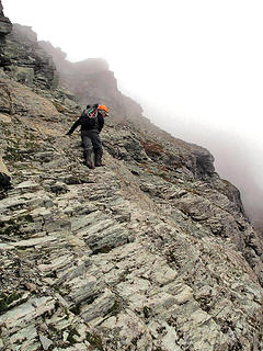 Down Sloping Rocks... Photo By Gimp 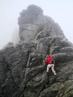 Climbing the Notch 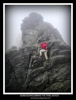 Coming out of the notch 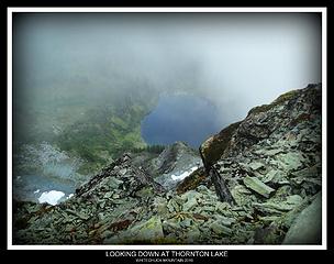 Thornton Lake Far, Far Below 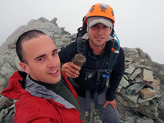 Summit Stoked!!! Photo By Gimp 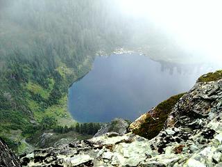 Thornton Lake Zoomed In 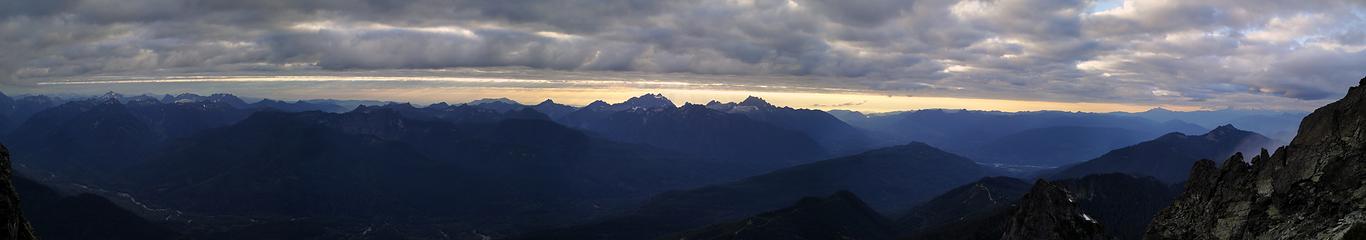 Pano Looking Northwest to Southwest 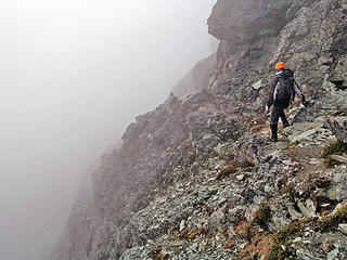 Crumbling Ledges Going Down... Photo By Gimp 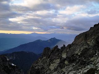 Mt Baker in the clouds 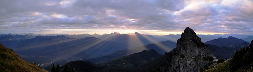 The evening sunset showing off its impressive rays cutting through the valley below Whitechuck Mountain. 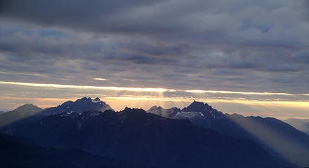 Three Fingers and Whitehorse Oasis 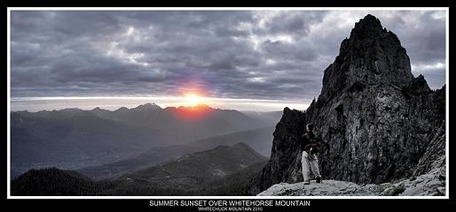 Gimpilator enjoys the sunset from high up on Whitechuck Mountain. 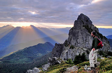 Epic Moment 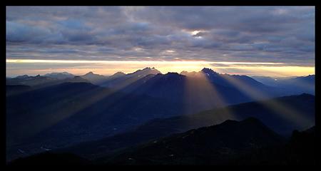 Awesome Rays Of Light 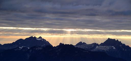 Three Fingers and Whitehorse Highlighted 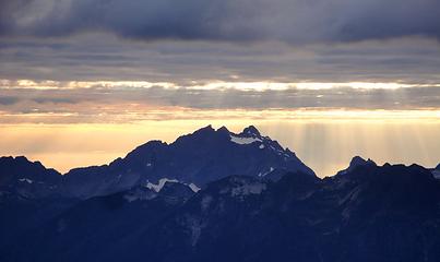 Three Fingers Mountain 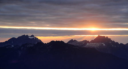 Colors over Three Fingers and Whitehorse 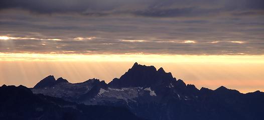 Whitehorse Mountain  Gimpilator stepped right into one of the impressive sun beams on Whitechuck Mountain 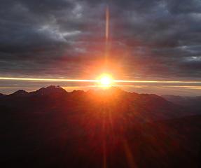 Looking into the sunset 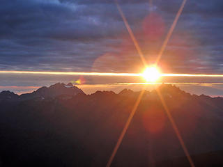 Good Freakin Night!!! Photo By Gimp
|
| Back to top |
  
|
|
Go Jo
of the lykkens

Joined: 08 Jun 2003
Posts: 2248 | TRs | Pics
Location: Around The Bend |
|
Go Jo
of the lykkens
|
Wed Sep 29, 2010 2:02 pm |
|
|
+ I especially like the perspective on 'The Crux'
|
| Back to top |
|
|
Dayhike Mike
Bad MFKer
Joined: 02 Mar 2003
Posts: 10958 | TRs | Pics
Location: Going to Tukwila |
Tom and I were up there on Saturday and I noticed your second visit with Gimpilator. Sorry to hear you didn't have better views to the east on your second visit either. Glacier looks like it's right in your lap.
"There is only one basic human right, the right to do as you damn well please. And with it comes the only basic human duty, the duty to take the consequences." -P.J. O'Rourke
"Ignorance is natural. Stupidity takes commitment." -Solomon Short
"There is only one basic human right, the right to do as you damn well please. And with it comes the only basic human duty, the duty to take the consequences." -P.J. O'Rourke
"Ignorance is natural. Stupidity takes commitment." -Solomon Short
|
| Back to top |
|
|
Jim Dockery
Member

Joined: 12 Sep 2007
Posts: 3092 | TRs | Pics
Location: Lake Stevens |
Good shots, I esp. like the God Rays in the first sunset pano 
|
| Back to top |
|
|
Tag Man
side hiller

Joined: 20 May 2008
Posts: 602 | TRs | Pics
Location: Where the roots all twist... |
|
Tag Man
side hiller
|
Wed Sep 29, 2010 3:09 pm |
|
|
Wow, great shots! Talk about being at the right place at the right time. Thanks for sharing!
|
| Back to top |
|
|
Magellan
Brutally Handsome

Joined: 26 Jul 2006
Posts: 13116 | TRs | Pics
Location: Inexorable descent |
|
Magellan
Brutally Handsome
|
Wed Sep 29, 2010 3:11 pm |
|
|
Great pictures BD! Nothing quite like God throwing a few rays your way. That stuff looks way harder than when I did it. I might have to go back just to see if I was crazy. 
|
| Back to top |
|
|
Tom
Admin
Joined: 15 Dec 2001
Posts: 17853 | TRs | Pics
|
|
Tom
Admin
|
Wed Sep 29, 2010 3:25 pm |
|
|
Edit: Sorry, my bad. I misread something to read there was some class 4. Sounds like you took the same route we did. I sure was glad to get past some of the exposed loose stuff near the top. Sounds like that's what you're referring to as the crux.
Great pics BTW.
|
| Back to top |
|
|
beaudaddy
Coast To Cascades
Joined: 25 Feb 2010
Posts: 401 | TRs | Pics
Location: Tulalip, WA |
|
beaudaddy
Coast To Cascades
|
Wed Sep 29, 2010 4:55 pm |
|
|
Thanks for the comments everyone.
Dayhike Mike- now I feel like I need to go up there again to check out the views to the East.  . Maybe tomorrow afternoon or something.
rbuzby- my camera is a Sony cyber-shot. I wish I had a nice camera to really draw in a better/closer idea of the experience. I edit my photos through Microsoft Office Picture Manager. I think it's pretty standard on most computers. No real "software", unless that program is something special. Lol
Tom- Not sure how many routes there are, but the one we took is called the Northwest Ridge Route. It looked like the standard route from the faint dusting of foot traffic. Not sure where I mentioned it was class 4. If you had a solid fall in the crux it would be a miracle to survive. Everyone seems to agree this route is class 3 in spots. For us, the down sloping rock was more unprotected than the notch. The notch would be sketchy if it was wet or icy. I think I mentioned that already. If you have some pictures that show an easier, less exposed route I would love to see them. . Maybe tomorrow afternoon or something.
rbuzby- my camera is a Sony cyber-shot. I wish I had a nice camera to really draw in a better/closer idea of the experience. I edit my photos through Microsoft Office Picture Manager. I think it's pretty standard on most computers. No real "software", unless that program is something special. Lol
Tom- Not sure how many routes there are, but the one we took is called the Northwest Ridge Route. It looked like the standard route from the faint dusting of foot traffic. Not sure where I mentioned it was class 4. If you had a solid fall in the crux it would be a miracle to survive. Everyone seems to agree this route is class 3 in spots. For us, the down sloping rock was more unprotected than the notch. The notch would be sketchy if it was wet or icy. I think I mentioned that already. If you have some pictures that show an easier, less exposed route I would love to see them.
|
| Back to top |
|
|
GaliWalker
Have camera will use

Joined: 10 Dec 2007
Posts: 4930 | TRs | Pics
Location: Pittsburgh |
|
GaliWalker
Have camera will use
|
Wed Sep 29, 2010 5:07 pm |
|
|
Your photos of the sunbeams are fantastic! I've been lucky only twice to witness such sunbeams (once at Cutthroat Pass in the North Cascades and once in West Virginia last year), but was unable to capture them as well as you did.
|
| Back to top |
|
|
Tom
Admin
Joined: 15 Dec 2001
Posts: 17853 | TRs | Pics
|
|
Tom
Admin
|
Wed Sep 29, 2010 5:15 pm |
|
|
There are some key cairns to guide you along the way. If your route took you to where you can see the glacier you may have been off route. If you diverted to that viewpoint then you were probably on route. You might have seen a cairn with engineer tape. That's a critical junction to remember on the way down. If you miss it you'll hit that viewpoint that looks down on the glacier. I'll see if any of my pics show the route. I do have a GPS track but my GPS was flaking out so not reliable.
Edit, here's a few pics I took on the way down. I'll add a few labels. Also, here's my GPS track. It's clearly off (shifted right) on the way down. The route pretty much avoids hitting the ridge top (despite what my GPS track might show).
 5 labels Mike taking in the views. Bootpath down is visible.
|
| Back to top |
|
|
fatoldman
Member

Joined: 22 Jan 2009
Posts: 19 | TRs | Pics
|
I did this peak solo way back around 1980. A day similar to yours. I almost turned back several times on those wet sloping ledges. The notch block stopped me for a while getting past it. I made it to the top but going back down was not fun. The glacier was much bigger 30 years ago, good to see it is still there.
|
| Back to top |
|
|
beaudaddy
Coast To Cascades
Joined: 25 Feb 2010
Posts: 401 | TRs | Pics
Location: Tulalip, WA |
|
beaudaddy
Coast To Cascades
|
Wed Sep 29, 2010 5:39 pm |
|
|
For anyone reading this report please don't get confused. There is a visible bootpath for most of the way up the west side. The very last steep heather gully will bring you to a junction. At this junction you will see a cairn wrapped in pink ribbon. If you go to the left there is a great view point of the Glacier. This direction won't take you to the summit unless you are rock climbing. From the marked junction take a right. From here it is a visible bootpath. If you keep looking ahead you will see strategically placed cairns. The crux for us was a section of solid downsloping slabs with loose gravel on top. At this section there is no other routes. Headwall above to your left and cliff to your right below. Not long after this is a 20' notch. I did not see any other ways around, but to downclimb the notch. I don't know about anyone else, but I wouldn't want to fall here. You can see my picture of Gimpilator that if you lost both hands here, you would most likely fall unless you have great balance or super skills. We didn't run across any class 4, but if you were off route I'm sure it's there somewhere. Maybe the pictures make it look more gnarly than what it is??!! IDK
|
| Back to top |
|
|
pimaCanyon
Member

Joined: 13 Jul 2007
Posts: 1304 | TRs | Pics
Location: at the bottom of the map |
Stunning photos. What a gift to have been up there for that.
It's never too late to have a happy childhood
It's never too late to have a happy childhood
|
| Back to top |
|
|
puzzlr
Mid Fork Rocks

Joined: 13 Feb 2007
Posts: 7220 | TRs | Pics
Location: Stuck in the middle |
|
puzzlr
Mid Fork Rocks
|
Wed Sep 29, 2010 9:25 pm |
|
|
I like the dizziness I get when looking at "The Crux" in large size.
How nice to be out to get light like that, and you made the best of it. I've just upgraded my camera gear a notch recently because a couple times in the last year I happened to be in the right spot, right time and felt like my old gear was inadequate to the task.
|
| Back to top |
|
|
Magellan
Brutally Handsome
Joined: 26 Jul 2006
Posts: 13116 | TRs | Pics
Location: Inexorable descent |
|
Magellan
Brutally Handsome
|
Wed Sep 29, 2010 9:38 pm |
|
|
Nice add-ons Tom. I'm so jealous I couldn't go that day. My two days there have been less than stellar.
Each man has his comfort level. Beau and Adam thought the gravely down sloping ledges were cruxy. I believed if I slipped, all I had to do was spread eagle flat and I would stop. It is true you are at the top of some big cliffs.
What bothered me is the first move down into the notch. You have to reach around that bulge and really hug it. I did not feel like I was leaning in so it made me nervous. The first move is not directly above the notch, and a fall would be bad.
|
| Back to top |
|
|
|
|
You cannot post new topics in this forum
You cannot reply to topics in this forum
You cannot edit your posts in this forum
You cannot delete your posts in this forum
You cannot vote in polls in this forum
|
Disclosure: As an Amazon Associate NWHikers.net earns from qualifying purchases when you use our link(s). |


