| Previous :: Next Topic |
| Author |
Message |
mhutch
Member


Joined: 21 Sep 2008
Posts: 168 | TRs | Pics
|
|
mhutch
Member
|
 Sun Sep 26, 2010 5:03 pm |
|
|
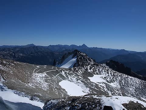
Tried this trip a few weeks ago as an overnight, ended up getting socked in and turning around due to lack of views. So with a clear Saturday in the forecast, I had to give it another try as a dayhike. Was able to spend the night up past Roslyn, got up early and drove to the TH in the dark, arriving around sunrise. Hit the trail just before 7:00am. Made it up to Squaw Lk. in about an hour.
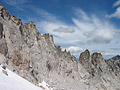
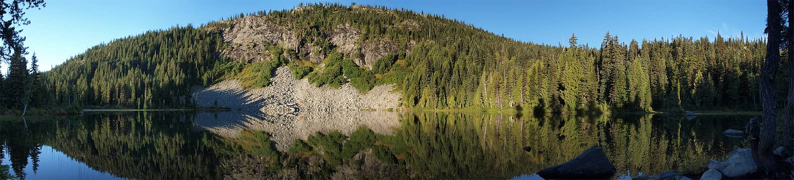 Squaw Lk. 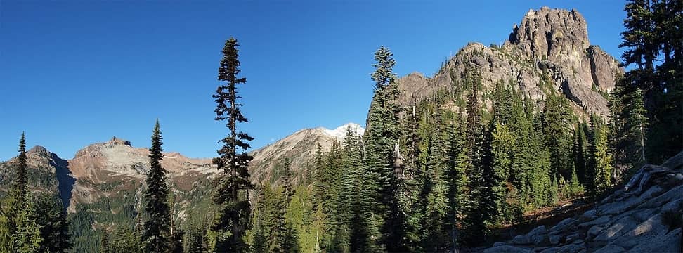 Cathedral pass pano 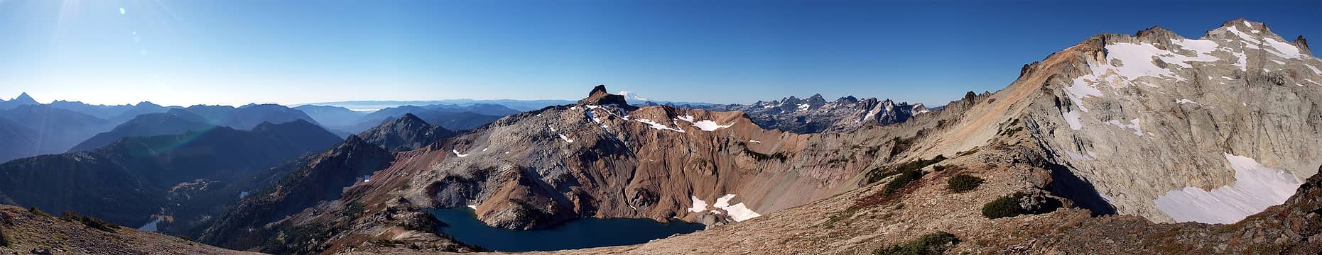 Stuart, Citadel, Circle Lk., crest peaks, SE Ridge 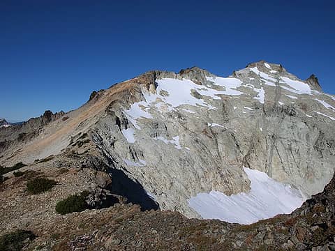 Looking up SE ridge 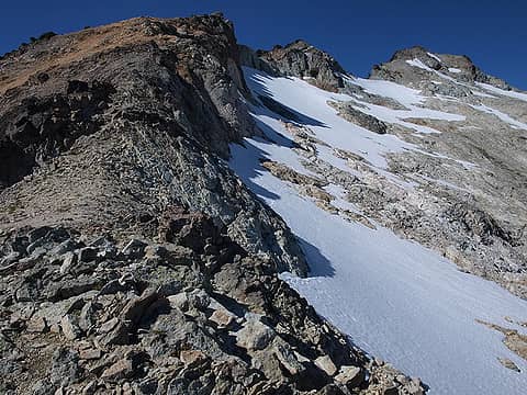 I left the ridge just above here to the saddle below the E summit, see tracks...  East summit pano 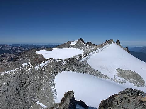 Looking towards the West and Middle summits 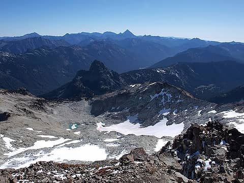 Looking back at Cathedral Rock 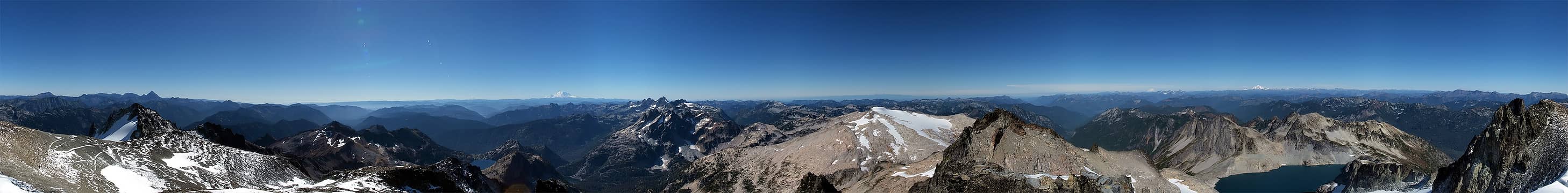 West summit pano 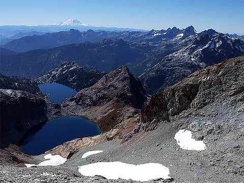 Venus and Spade Lks. 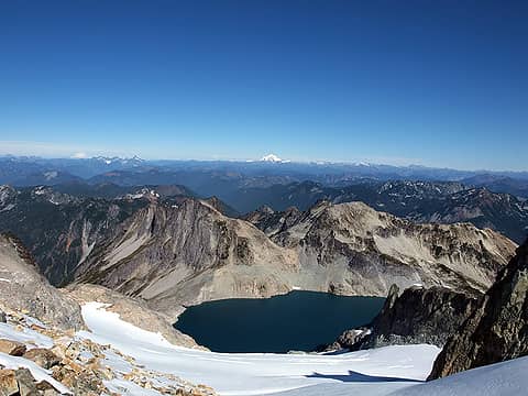 Pea Soup Lk. 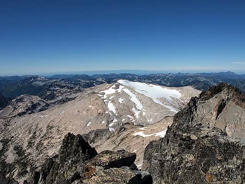 Mt. Hinman 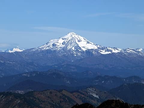 Glacier Pk. 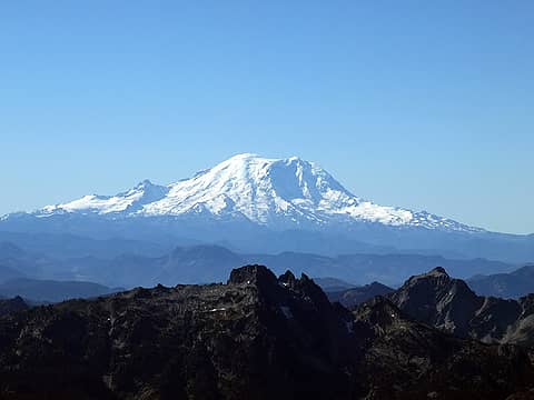 Mt. Rainier 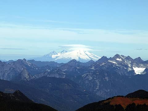 Mt. Baker 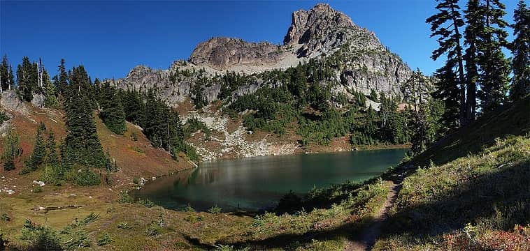 back at Peggy's Pond 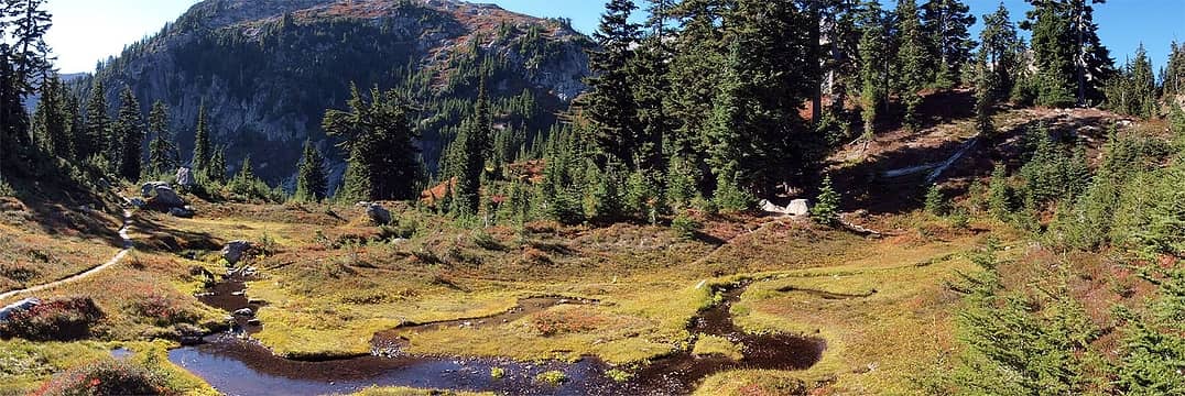 Basin below Peggy's Pond 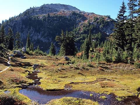 Color below Peggy's Pond 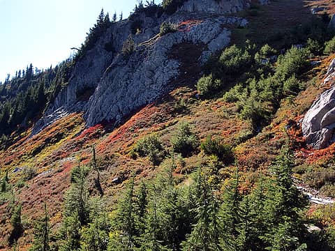 More color 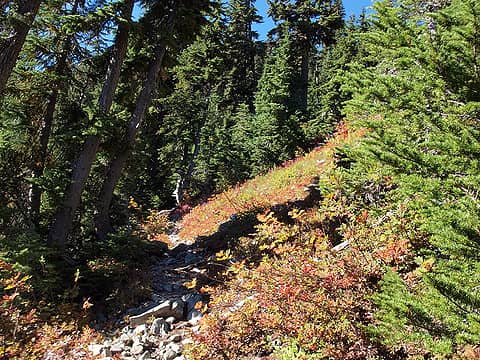 Trail to Peggy's Pond
|
| Back to top |
  
|
|
mtn.climber
Member

Joined: 29 Jul 2008
Posts: 1204 | TRs | Pics
Location: The Lost Horizon |
Nice photos.  A great day to be out in the mountains.
Reach for the sky, cuz tomorrow may never come.
Live the life of love. Love the life you live.
Reach for the sky, cuz tomorrow may never come.
Live the life of love. Love the life you live.
|
| Back to top |
|
|
Tom
Admin
Joined: 15 Dec 2001
Posts: 17857 | TRs | Pics
|
|
Tom
Admin
|
Sun Sep 26, 2010 5:40 pm |
|
|
Nice report and pics.
| Quote: | | I left the ridge just above here to the saddle below the E summit. |
That's the correct route. It's a common mistake to continue up the ridge. Did the other parties summit? 
|
| Back to top |
|
|
mhutch
Member
Joined: 21 Sep 2008
Posts: 168 | TRs | Pics
|
|
mhutch
Member
|
Sun Sep 26, 2010 8:24 pm |
|
|
thanks. yeah, cutting across below 7662' is definitely a faster and easier way to go. one group made it for sure, pretty sure the other did as well, since I passed them as they were heading across to the west summit. watched them both come over the ridge and down to the saddle, looked tedious...
|
| Back to top |
|
|
Magellan
Brutally Handsome

Joined: 26 Jul 2006
Posts: 13117 | TRs | Pics
Location: Inexorable descent |
|
Magellan
Brutally Handsome
|
Sun Sep 26, 2010 8:53 pm |
|
|
Beautiful.
|
| Back to top |
|
|
veronika
Member

Joined: 25 Apr 2010
Posts: 3015 | TRs | Pics
Location: On the road |
|
veronika
Member
|
Sun Sep 26, 2010 9:53 pm |
|
|
+++
Take risks not to escape life, but to prevent life from escaping
I may not have anyone rocking my world right now but, I don't have anyone messing it up either.
Take risks not to escape life, but to prevent life from escaping
I may not have anyone rocking my world right now but, I don't have anyone messing it up either.
|
| Back to top |
|
|
Sadie's Driver
Sadie's Driver

Joined: 24 Apr 2006
Posts: 1763 | TRs | Pics
Location: Welcome Pass |
Nice - area around Peggy's Pond looks a lot different (color-wise) than it did two weeks ago.
Four-paw buddy lets me tag along!
Four-paw buddy lets me tag along!
|
| Back to top |
|
|
chiwakum
not credible

Joined: 29 Jun 2009
Posts: 980 | TRs | Pics
Location: Ballard |
|
chiwakum
not credible
|
Sun Sep 26, 2010 10:54 pm |
|
|
| Quote: | | There is a short section of very hard dirt covered in loose rock between the saddle below the E summit and the trail to the W and Middle that I missed on my way over from the E. Probably the sketchiest section for me, steep and hard to get footing on, passed another group heading up here. |
there's another sketchy section well below the east summit (closer to the NE ridge) that I would recommend not trying to scree hop down (I had a brief exciting moment of uncontrolled descent after landing on my butt as my feet went flying into space).
Glad you had much better weather than I did a few weeks ago. Great pics.
I can't fathom why people would stick to the SE ridge when the diagonal route across the mellow snowfield and rock is so easy and efficient.
Edit for clarification: I would recommend never gaining the ridge in the first place, instead stay well below it and then head NE after climbing above the upper basin...
|
| Back to top |
|
|
Go Jo
of the lykkens

Joined: 08 Jun 2003
Posts: 2248 | TRs | Pics
Location: Around The Bend |
|
Go Jo
of the lykkens
|
Sun Sep 26, 2010 11:07 pm |
|
|
|
| Back to top |
|
|
belowfellow
Transplant

Joined: 22 Feb 2009
Posts: 261 | TRs | Pics
Location: Seattle |
nice work bro, looking forward to Larch Maddness this weekend!
|
| Back to top |
|
|
silence
Member

Joined: 25 Apr 2005
Posts: 4420 | TRs | Pics
|
|
silence
Member
|
Mon Sep 27, 2010 7:23 am |
|
|
nice tr and pix .. thx for posting .. the obvious trail to the west summit .. left or right of the ridge fm the east peak?
PHOTOS
FILMS
Keep a good head and always carry a light bulb. Bob Dylan
PHOTOS
FILMS
Keep a good head and always carry a light bulb. Bob Dylan
|
| Back to top |
|
|
ICLIMB76
Member

Joined: 08 May 2007
Posts: 222 | TRs | Pics
Location: Tacoma, Wa. |
|
ICLIMB76
Member
|
Mon Sep 27, 2010 9:21 am |
|
|
Nice job. Did you get a chance to see how many people were camped at Peggys Pond?
|
| Back to top |
|
|
mhutch
Member
Joined: 21 Sep 2008
Posts: 168 | TRs | Pics
|
|
mhutch
Member
|
Mon Sep 27, 2010 6:10 pm |
|
|
silence: the trail goes along the ridge to the left of the snow/glacier and from there cuts pretty much straight across to the W peak. it actually looks like there are 2 parallel trails. they're more obvious in the pano from the W summit and this shot from the W summit looking at the E one...
 Mt. Daniel E summit from W
|
| Back to top |
|
|
Daniel G
Member

Joined: 25 May 2010
Posts: 7 | TRs | Pics
|
|
Daniel G
Member
|
Thu Sep 30, 2010 5:23 pm |
|
|
Nice report. Did you see the need for crampons and/or ice axe.
|
| Back to top |
|
|
mhutch
Member
Joined: 21 Sep 2008
Posts: 168 | TRs | Pics
|
|
mhutch
Member
|
Thu Sep 30, 2010 10:30 pm |
|
|
thanks, there was no need for an ice axe or crampons. poles would be helpful for the snow sections and maybe the short section on the way to the W though...
|
| Back to top |
|
|
|
|


