| Previous :: Next Topic |
| Author |
Message |
Gimpilator
infinity/21M


Joined: 12 Oct 2006
Posts: 1684 | TRs | Pics
Location: Edmonds, WA |
Let's start with a couple of my photos of Sloan from surrounding peaks:
At 7835 feet high, Sloan Peak is the 22nd most prominent point in Washington State. Catching a glimpse of Sloan from any angle gives a formidable impression. Fred Beckey has noted in his Cascade Alpine Guide that Sloan Peak has been called the Matterhorn of the Cascades. The fact that this massive precipitous mountain was not successfully ascended until 1921 speaks for itself. Thats not to say that climbers didnt try.
How about a game of label those peaks in this panorama? How many can we get? There's a bigger version here.
I met Beau in a chance meeting this last February at the Perry Creek traihead. We were already familiar with each other from our activity on Summit Post. I could immediately relate to Beau with his passion for peakbagging and affection for the Mountain Loop Highway. In July we met for our first trip together to do Winchester and Larrabee in the North Cascades. Then in September we met again one evening after work to climb White Chuck. Having established a mutual trust and respect for each other, it was time for a real test. One last big climb before the coming snows.
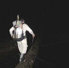
I went to bed at 8:30 pm and lay there thinking about the corkscrew route. A major river crossing which sometimes requires wading up to your thighs, an overgrown trail leading up to exposed slabs, a glacier crossing, steep narrow ledges with cliffs above and below, scrambling up loose dirt and rocks to a maze of route finding issues. I had to sleep because the alarm was set for 2:30 AM but my heart was racing. I felt like I had just drunk a whole pot of coffee and was being chased by wild dogs. There were so many uncertainties. This would be my first time crossing a glacier as a two-person team rather than three. What would the river crossing be like in the dark? This would be Beaus first time on a glacier. Sleep was slow to come and fitful all night.
During the drive the next morning I had to concentrate to cut sections of cord and melt the ends with a lighter. It took me awhile to remember the knots but eventually I completed the job and Beau had a new set of chest and foot prussiks. The first of three crossings of the North Fork Sauk River was not fun. There was a fallen log to walk across but it was narrow. Looking down into the deep water on either side with the light of my headlamp I imagined the consequences of a fall. We made it across without incident but the next two crossings were equally unfavorable. At one point we had to switch from one log to another to another to get across a huge logjam. Near the bank I had to tightrope walk down a terribly narrow fallen alder, which was suspended over a deep pool. When we were safely on shore Beau named that part of the route down sloping alder which had me crack up and release all the nervous tension. I knew he was referring to the down sloping rock of our last climb together on White Chuck. Down Sloping Alder then became the slogan of the day.
Beyond the river the climbers path was brushy, and difficult to follow in the dark. Pink ribbons placed on tree branches by other climbers were helpful. We crossed under one major waterfall. After gaining 3000 vertical feet we came into a small valley and had our first view of the summit. A rush of excitement hit us and refueled our motivation to push on. It would be another 3000 of vertical before we got there. The path terminated near a small meadow, at the base of exposed granite slabs. It was amazing to think that at one time the glacier had extended down this far. We scrambled up the slabs below the northeast ridge aiming for the low spot just west of Point 5852.
On the ridge crest we could see a large portion of the glacier we would be crossing. The crevasses were wide open and clustered in bunches where the ice was passing over convex slopes. Where the slope was concave, the crevasses were closed up and there was no visible threat. These concave areas I considered safe for travel and this was where we would try to weave our way through. Glacier travel in October has some pros and cons. The good thing is that the summers melt has made it so that you can see where all the dangers are. The bad thing is that most of the snow bridges are long gone and the ones that remain and usually narrow and untrustworthy. Beau and I briefly discussed proper glacier travel etiquette and I stressed the point that if you fall into a crevasse or otherwise you should yell FALLING so that the other climbers can immediately go into self-arrest. We then roped up, fixing prussik knots, donning helmets, glacier goggles, and our ice axes.
Our goal was to reach the highest point of the glacier on its southwest corner. Starting out was easy enough. I led up a series of ramps between the clusters of crevasses. Then the going got a little tricky. We were right in the middle of the upper part of the glacier but we had come to an impasse. Here we were boxed in by crevasses on three sides. I tried poking around looking for an alternative way. It seemed like if we could just get up above the big one that was right above us, we could continue our direction of travel. I saw a series of angled snow bridges that looked doable but dangerous. I tried to weigh the hopes of our having enough time to make it to the summit against the safety of retreating and looking for a better way through the maze. I was afraid that a retreat would cost us too much time and we might lose our chance. I decided to try the bridges. The first one was short but the upper lip of the crevasse was higher and very steep. I made it across and told Beau not to step on the thinner middle part of the bridge. The next bridge was very narrow. It was about 9 feet long and only a foot wide in the middle. Looking down, I could see a fall here would be at least 35 feet. Since we were in a narrow section located between two different crevasses, if I went in here, I would pendulum swing a long way before Beau could stop my fall. I didnt like it. I told Beau to turn back. We would have to find another way.
For the next 45 minutes we zigzagged back and forth trying to find a way through the maze. Some route descriptions suggested traversing the upper edge of the glacier but I was going on the advice of a friend who had climbed Sloan recently and suggested cutting across about two thirds of the way up. I used my GPS to make digital tracks so we could follow our same route on the descent. Finally, at the southwest corner of the glacier, we stepped back onto solid rock. We quickly untied and left our rope, harnesses and axes in a heap.
Beyond the glacier the route turns onto the south face and follows a series of high ledges perched precipitously over 400 foot cliffs. This section of the corkscrew route is semi-famous among the local hiking culture. The boot path here is impressive in its placement and exposure but it seemed easy to us after our difficulty on the glacier. Fairly soon we had a good perspective looking up at the remainder of the peak, it's sheer south face. Pushing on we turned another corner and found that we were now on the west face, overlooking the Puget Sound, which was covered with a sea of clouds. Beyond the clouds the entire Olympic Range was visible. Beau began spouting out expressions of disbelief and amazement at what we were seeing. I had to admit, we werent even on the summit yet, but already these were the best views from any peak I had ever seen.
The path ended at the base of a steep gully filled with loose stones and dirt. The rock in the fissure was of a different composition and was eroding much faster than the surrounding rocks. We scrambled up the gully hugging the left wall, which offered more handholds. At the top of the gully we turned left bearing north for our final approach of the summit. We were getting close. I could feel it. Now the route became harder to decipher. Where there was dirt, multiple faint paths were less convincing. Where there was rock, we did a lot of scrambling but none of it overly challenging. One move required holding onto a wall of rock while sidestepping a ledge about 10 inches wide, with a long drop behind. Eventually we ended up on giant talus and an exposed ridge top. Then I saw the summit. It was only 30 feet away now. SLOAN PEAK! I could not believe it. How many times had I viewed this monster from every angle on the surrounding smaller peaks? How many times had I thought to myself that it was probably outside my range of abilities? And there it was right in front of me. The highest point. I could reach out and touch it. I did. I followed the ridge crest which was a complete drop on the east side, 450 feet straight down to the glacier. Exercising some care I pulled myself up the last rock and stood on top. Beau was right behind me.
We celebrated our summit with food and re-hydration salts. We could see all the way from Mount Baker up north to Glacier Peak in the east to Mount Adams down south. I told Beau that this had been one of the best climbs of my life, a true favorite right in league with Kilimajaro and Pico de Orizaba. To our dismay, we discovered that even though we had each started with more than 3 liters of water, we were down to about a half a cup. It was surprisingly hot for October, but there was a trickle down below the glacier and thankfully Beau had carried a filter. We could make it that far.
Having started a 6:05 AM it was now 2:00 PM and the sun would be setting in roughly 5 hours. We were reluctant to leave such a splendid summit but it was the responsible thing to do. We scrambled down and followed the ledges back round to the far side of the mountain and the glacier. I was longing for the assurance that awaited us on the far side. If we could cross this mass of broken ice one more time, then surely no substantial malady could threaten us. I switched my GPS back on and we followed our digital tracks back through the labyrinth. The crossing was shorter and less eventful than the first time. We were about 100 feet from the edge of the glacier when I heard a sickening noise that turned my stomach. It had been a horrible whoomfing noise from underneath the snow somewhere nearby, the sound of stuff falling away. I froze and turned around asking Beau if he had heard it. He could see from the look on my face that I was concerned. He hadn't heard it, so maybe I had imagined it? We continued on, getting closer to the edge. Then I heard it again, twice. This time Beau heard it too. It's a god-awful sound to hear when you're crossing a glacier. Thankfully we made it to the rocks without any ground giving away.
We refilled our water at the trickle and moved on down the slabs knowing that daylight would soon be leaving us. We made it past the meadow and into the timber before the dark closed in. I realized that the fall of night marked our moving time to be about 13 hours. It was fully dark when we reached the river crossings. I noticed that the water level had risen and some of the logs were now partially suspended and floating unstably. To make things more spicy the down-sloping alder over the deep pool now sagged considerably when any weight was placed upon it. There was no other way across. We had crossed those logs in the dark that morning and now it was time to cross them in the dark a second time. Maybe it was a good thing that we couldnt fully see the rushing water below us. Neither of us took a spill. In fact after crossing so much rugged terrain, we hadnt had a single fall all day. Back at the truck, it felt good to sit down after 14 hours on our feet. It felt good to take the boots off.
Id like to say thanks to Beau for doing some hair-raising driving that night in his exhausted state and thanks also for carrying that water filter. I'd also like to thank Josh Lewis for loaning us his lightweight glacier rope.
|
| Back to top |
  
|
|
beaudaddy
Coast To Cascades

Joined: 25 Feb 2010
Posts: 401 | TRs | Pics
Location: Tulalip, WA |
|
beaudaddy
Coast To Cascades
|
 Wed Oct 06, 2010 4:24 pm |
|
|
Im glad I could share this trip with a guy that is equally, if not more passionate about the Mountain Loop Highway Peaks than I am.
Sloan Peak is a mountain that is very noticeable from many different viewpoints in the area. It was a blast to finally see things from Sloan Peaks perspective. I know that enjoying it from other summits is always exciting because it lets off such wonder and prominence
I have to say this was a challenging trip, but the reward was more than I could have expected. The views from the summit are the best I have experienced. This mountain has a bit of everything and doing it in one day is not for the faint at heart. Im glad this one worked out. Thanks Gimpilator. Here are some more pics of the trip...
 1 of 3 river crossings in the dark 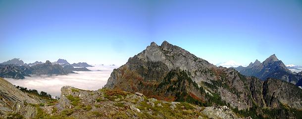 Three Fingers, Forgotten, Whitehorse, Bedal, Baker, White Chuck, Pugh and Shuksan 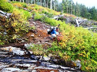 Berry Munchin 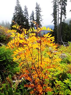 Fall Colors 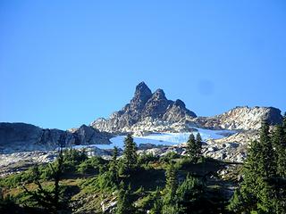 Sloan Peak 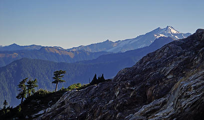 Glacier Peak and Red Mountain 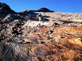 More Slabs 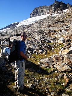 Adam Stoked 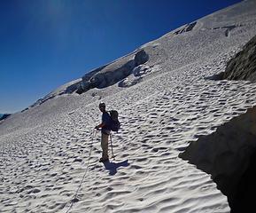 Just getting on the Glacier 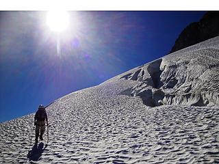 Into The Sun 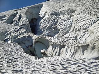 Broken Up Glacier 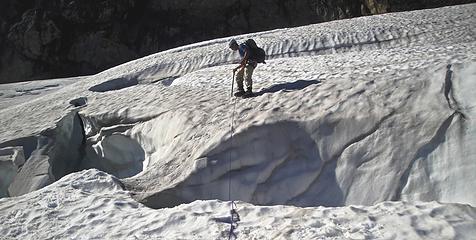 Crevasse Crossing 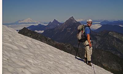 Gimpilator Soaking in the peaks 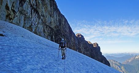 Headwall Epics 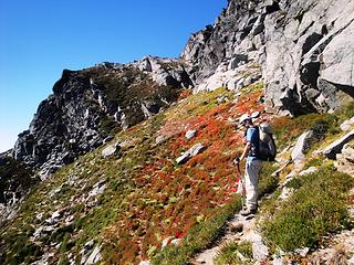 Corkscrew Route 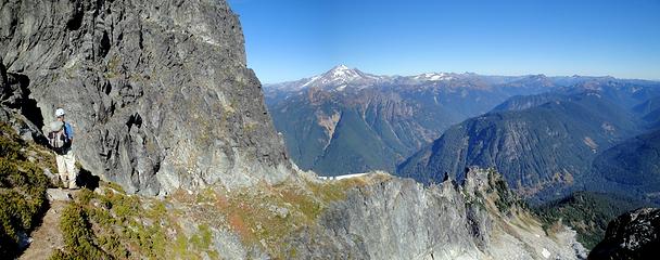 Sloan's Jagged Ridge 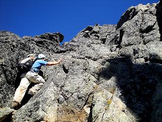 Going Up 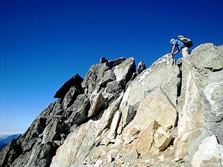 Couple Moves Before Summit 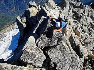 Jagged Sloan Summit 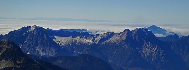 Vesper To Big Four 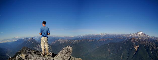 Gimp On Sloan Summit 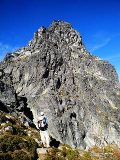 Corkscrew Below, Summit Block Above 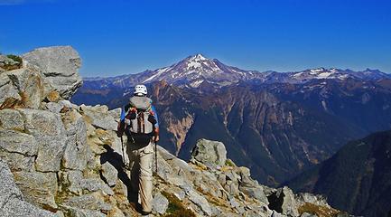 Glacier Peak 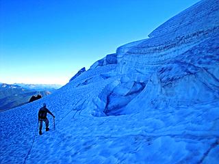 Broken Up Glacier 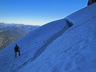 Steep Glacier Travel 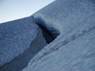 Deep Crevasse 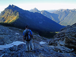 Going Down Slabs 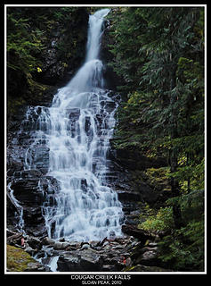 Cougar Creek Falls 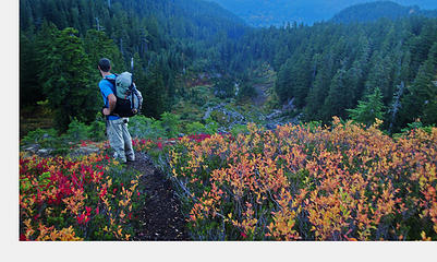 Fall Colors 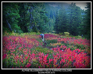 Fall Colors
|
| Back to top |
|
|
SeanSullivan86
Member

Joined: 25 Jul 2009
Posts: 681 | TRs | Pics
Location: Seattle, WA |
Nice going, not sure I have the nerves for that one yet...
Here's Sloan (left of center) from 46 miles away, near the summit of Little Annapurna on 10/3:
|
| Back to top |
|
|
Dane
Other

Joined: 14 Mar 2006
Posts: 2466 | TRs | Pics
Location: Seattle |
|
Dane
Other
|
Wed Oct 06, 2010 4:45 pm |
|
|
That's one I've eyed, on clear days, from the Olympics. Congrats on what looks to be a long, varied, and challenging summit!
Without judgement what would we do? We would be forced to look at ourselves...
-Death
Without judgement what would we do? We would be forced to look at ourselves...
-Death
|
| Back to top |
|
|
Chief Joseph
Member

Joined: 10 Nov 2007
Posts: 7709 | TRs | Pics
Location: Verlot-Priest Lake |
Go placidly amid the noise and waste, and remember what comfort there may be in owning a piece thereof.
|
| Back to top |
|
|
tigermn
Member

Joined: 10 Jul 2007
Posts: 9242 | TRs | Pics
Location: There... |
|
tigermn
Member
|
Wed Oct 06, 2010 6:09 pm |
|
|
Wow what a trip and nice writeup.
Way beyond my comfort level or ability but in a sense I had a feeling of being there reading the report and seeing the great pictures.
|
| Back to top |
|
|
mgd
Member

Joined: 27 May 2003
Posts: 3143 | TRs | Pics
Location: Full Moon Saloon |
|
mgd
Member
|
Wed Oct 06, 2010 6:22 pm |
|
|
|
| Back to top |
|
|
Magellan
Brutally Handsome

Joined: 26 Jul 2006
Posts: 13116 | TRs | Pics
Location: Inexorable descent |
|
Magellan
Brutally Handsome
|
Wed Oct 06, 2010 6:27 pm |
|
|
|
| Back to top |
|
|
Gwen
LO Girl-of-the-Month
Joined: 14 Feb 2010
Posts: 1673 | TRs | Pics
|
|
Gwen
LO Girl-of-the-Month
|
Wed Oct 06, 2010 7:39 pm |
|
|
It's like a game of Where's Waldo. I see 4 but can't find the 5th.
Tomorrow's not promised to anyone, so be bold, scare yourself, attempt something with no guarantee of success. You'll be amazed at what you can achieve. -Olive McGloin
Tomorrow's not promised to anyone, so be bold, scare yourself, attempt something with no guarantee of success. You'll be amazed at what you can achieve. -Olive McGloin
|
| Back to top |
|
|
Spotly
Member

Joined: 06 Jan 2004
Posts: 3723 | TRs | Pics
Location: Spokane Valley |
|
Spotly
Member
|
Wed Oct 06, 2010 7:43 pm |
|
|
What an excellent looking route! Thanks for the great write-up and pics.
|
| Back to top |
|
|
puzzlr
Mid Fork Rocks

Joined: 13 Feb 2007
Posts: 7220 | TRs | Pics
Location: Stuck in the middle |
|
puzzlr
Mid Fork Rocks
|
Wed Oct 06, 2010 9:26 pm |
|
|
That's a great climb. One of the most satisifying aspects is how you see it from every other peak in the central cascades. Your partners will get tired of you saying "I climbed that"
|
| Back to top |
|
|
Gwen
LO Girl-of-the-Month
Joined: 14 Feb 2010
Posts: 1673 | TRs | Pics
|
|
Gwen
LO Girl-of-the-Month
|
Wed Oct 06, 2010 10:35 pm |
|
|
Ah #3... that was the sneaky one.
Tomorrow's not promised to anyone, so be bold, scare yourself, attempt something with no guarantee of success. You'll be amazed at what you can achieve. -Olive McGloin
Tomorrow's not promised to anyone, so be bold, scare yourself, attempt something with no guarantee of success. You'll be amazed at what you can achieve. -Olive McGloin
|
| Back to top |
|
|
EastKing
Surfing and Hiking

Joined: 28 Mar 2007
Posts: 2082 | TRs | Pics
Location: 77 miles from Seattle! |
|
EastKing
Surfing and Hiking
|
Wed Oct 06, 2010 10:58 pm |
|
|
YouTube | SummitPost
Saw the depths of despair. Now I am salvaging what time I have left on Earth.
|
| Back to top |
|
|
Bryan K
Shameless Peakbagger

Joined: 29 Sep 2005
Posts: 5129 | TRs | Pics
Location: Alaska |
|
Bryan K
Shameless Peakbagger
|
Wed Oct 06, 2010 11:10 pm |
|
|
You guys have a really big pair of......helmets 
|
| Back to top |
|
|
tmatlack
Member
Joined: 21 Aug 2007
Posts: 2854 | TRs | Pics
|
|
tmatlack
Member
|
Thu Oct 07, 2010 3:26 am |
|
|
Hey,
Great photos, hairy log crossings. How is the road? Can a sedan make the last couple of miles?
Tom
|
| Back to top |
|
|
|
|


 Great report!
  Helluva an effort fellas.