| Previous :: Next Topic |
| Author |
Message |
Redwic
Unlisted Free Agent


Joined: 23 Feb 2009
Posts: 3292 | TRs | Pics
Location: Going to the Prom(inence) |
|
Redwic
Unlisted Free Agent
|
 Mon Oct 18, 2010 8:40 pm |
|
|
I had been wanting to attempt Gunn Peak for many years. Having been raised in the nearby city of Gold Bar, I looked at the Sky Peaks section of what is now Wild Sky Wilderness nearly every day throughout my childhood and early adulthood. However, summiting peaks within that region did not seem likely to occur until after I became a regular peakbagger 3-1/2 years ago. This year, I hoped to summit two major peaks within the Sky Peaks region of Wild Sky Wilderness: Mount Baring and Gunn Peak. I summited Mount Baring in June, but with other plans taking priority during Summer and early Autumn it appeared a Gunn Peak trip might have to wait another year. Then, unexpectedly, an extended Indian Summer weather pattern allowed for one more chance
I knew of Sultan Guy Andy from NWH, and we had PMed each other several times about possible peaks to attempt together near the Highway 2 corridor. When he asked where I planned to hike this past weekend, I told him I wanted to attempt Gunn Peak. He was willing to come along on the trip, despite having been to that summit approximately five years ago. He was hoping that we might be able to have enough time to summit one of the nearby sub-peaks on the adjoining ridges, if time and conditions allowed. I was comforted by his enthusiasm and knowledge of the terrain; I figured it would prove invaluable to our success. I had never personally heard of a successful unroped/unprotected attempt of Gunn Peak so late (mid-October) during any year, but we believed the Indian Summer type of conditions might allow us just such an opportunity. Technically, an Indian Summer occurs after frost but before snowfall, but the light dusting of snow in the alpine areas of Wild Sky Wilderness earlier during the week (before another sunny, warming trend) appeared to be neither significant nor measurable. We liked our chances.
We arrived at the cutoff road early, starting to hike at 7:00 AM. As we prepared to begin, Andy commented about the chances of encountering other people attempting Gunn Peak that day being highly unlikely. Shortly after saying that, an older gentleman and his dog arrived, looking for the entrance to the Gunn Peak route. We started hiking before the gentleman was even out of his vehicle, but he had caught up to us by the time we reached the old logging road on the north side of the stream crossings. An obvious trail headed north from the road, but it seemed to appear much sooner than my directions had suggested. Andy thought it might be the correct way, as did the man, but it quickly became a massive bushwhack. Andy and I turned around to find the correct route, while the man and his dog continued bushwhacking uphill. A little further west down the road, another obvious route headed north. But unlike the other route we had investigated, this one appeared at the approximate location I had been informed about, and appeared to be more heavily used. Soon thereafter, it became a steep climbers trail.
From this point on, the route did not waste any time gaining elevation. The route was easy to follow, although we took occasional quick rests for an energy boost to offset the steepness of the terrain. When we reached the first cliff wall, there was the older gentleman sitting on a rock with his dog. Somehow, he had managed to bushwhack through the thick forest at the base of the hill, and find the correct path. I was amazed by his determination and his quickness. From this point, it appeared the route had two possibilities. The gentleman checked out one option while Andy led me the other direction. We soon reached the infamous waterfall crossing, which was nothing more than a small trickle; probably the least amount it ever flows there. Then we had another steep forest climb, albeit a short jaunt, before side-traversing to the entrance of a very large gully. Andy recalled staying on one side of the gully, when he had previously been there. He warned me that we might encounter a lot of brush and slide alder, which we did. We quickly lost the official route, although we thought we were still on it because somebody had left pieces of colored ribbon/flagging tape periodically on the ground. We never retraced the route, and figuring it might just be overgrown we continued heading north to the cliffs ahead of us. The older gentleman called out to us; he was beyond us and on the other side of the gully. He found a gully near the cliffs to traversed up and over.
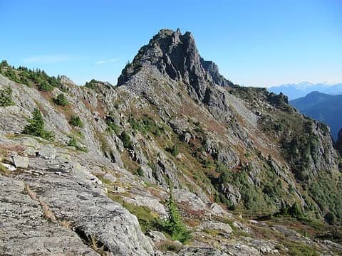
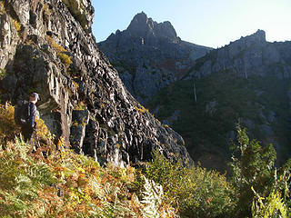 Andy heading towards the very large gully... 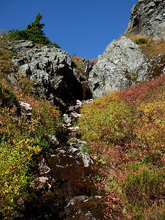 Ascending a streambed gully... 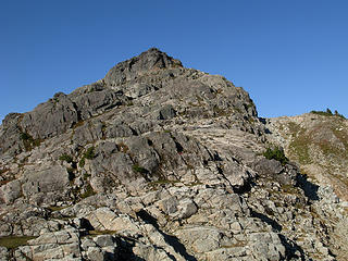 "Tailgunner" 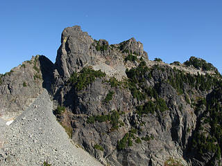 Our goal 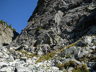 Finding the hidden gully... 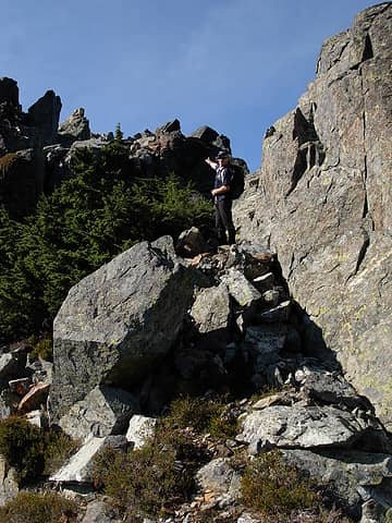 Andy leading to the summit... 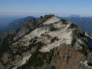 "Gunnshy" 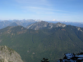 Wild Sky peaks to the northeast! 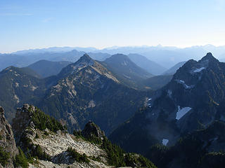 Wild Sky peaks to the east! 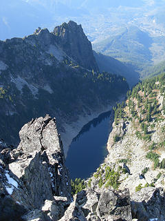 Gunn Lake 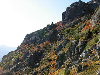 Looking at the slopes while heading down... 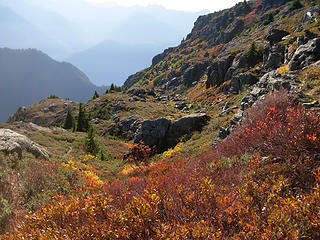 Nice colors!
60 pounds lighter but not 60 points brighter.
60 pounds lighter but not 60 points brighter.
|
| Back to top |
  
|
|
Eric
Peak Geek

Joined: 21 Oct 2002
Posts: 2062 | TRs | Pics
Location: In Travel Status |
|
Eric
Peak Geek
|
Mon Oct 18, 2010 9:51 pm |
|
|
Congrats on your summit, that is a fun scramble on top. We thought you would be OK with the nice weather but then when we encountered fresh snow we wondered if similar fresh snow on that ledge or in the narrow gully would give you guys problems. Glad to hear that it did not.
I would not have wanted to do that ascent by bushwhacking through the forest; the guy with the dog who did that had some serious gumption.
Hopefully with a little rest and relaxation your leg will be OK.
|
| Back to top |
|
|
Redwic
Unlisted Free Agent
Joined: 23 Feb 2009
Posts: 3292 | TRs | Pics
Location: Going to the Prom(inence) |
|
Redwic
Unlisted Free Agent
|
Mon Oct 18, 2010 11:44 pm |
|
|
| Eric wrote: | | Congrats on your summit, that is a fun scramble on top. We thought you would be OK with the nice weather but then when we encountered fresh snow we wondered if similar fresh snow on that ledge or in the narrow gully would give you guys problems. Glad to hear that it did not. |
I believe "Sultan Guy" has a few photos of the sketchy spots, and me looking like a goofball in each of those spots. 
60 pounds lighter but not 60 points brighter.
60 pounds lighter but not 60 points brighter.
|
| Back to top |
|
|
Sultan Guy
Member

Joined: 22 Jul 2008
Posts: 353 | TRs | Pics
Location: Now reinforced with Concrete |
It was so nice to have such fantastic weather and a great partner.
Here are some more pictures with some of "goofball" Redwic in action.
Yes I had already done this peak, but heck I just couldn't turn down the invite to do it again 
 Merchant Peak 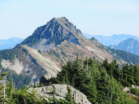 Nice view of Townsend Mtn. 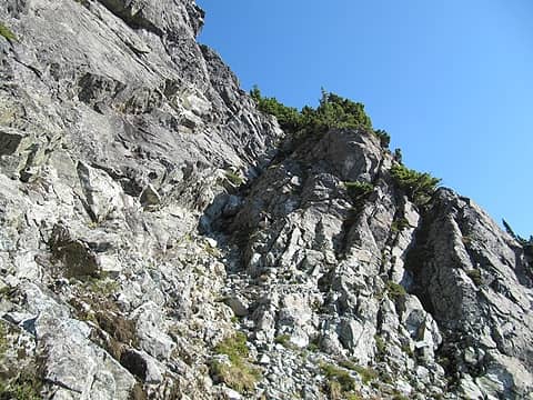 Redwic conquering the gully 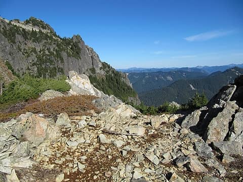 View from the ridge 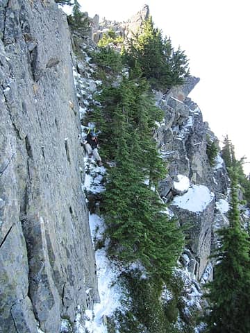 Fresh snow on north face ledge 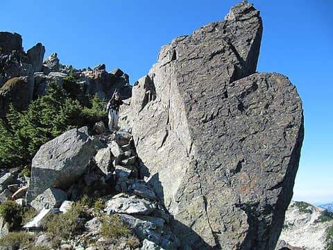 Neat boulder just below summit 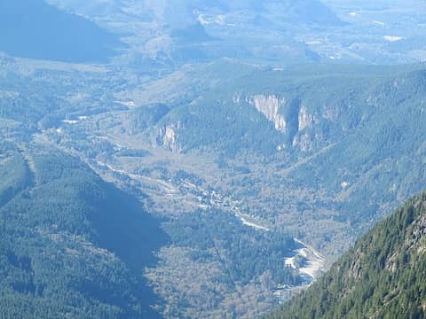 Tiny town of Index 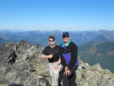 Two posers 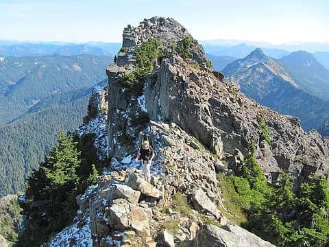 Summit ridge-snow on north face
Any worthwhile expedition can be planned on the back of an envelope- H. W. Tilman
Any worthwhile expedition can be planned on the back of an envelope- H. W. Tilman
|
| Back to top |
|
|
iron
Member

Joined: 10 Aug 2008
Posts: 6392 | TRs | Pics
Location: southeast kootenays |
|
iron
Member
|
Wed Nov 03, 2010 11:09 pm |
|
|
|
| Back to top |
|
|
EastKing
Surfing and Hiking

Joined: 28 Mar 2007
Posts: 2082 | TRs | Pics
Location: 77 miles from Seattle! |
|
EastKing
Surfing and Hiking
|
Thu Nov 04, 2010 8:43 am |
|
|
Excellent TR and photos! 
YouTube | SummitPost
Saw the depths of despair. Now I am salvaging what time I have left on Earth.
YouTube | SummitPost
Saw the depths of despair. Now I am salvaging what time I have left on Earth.
|
| Back to top |
|
|
Tall Hiker Man
Member

Joined: 23 Jun 2006
Posts: 346 | TRs | Pics
Location: Cashmere |
| Sultan Guy wrote: | Fresh snow on north face ledge |

|
| Back to top |
|
|
Redwic
Unlisted Free Agent
Joined: 23 Feb 2009
Posts: 3292 | TRs | Pics
Location: Going to the Prom(inence) |
|
Redwic
Unlisted Free Agent
|
Thu Nov 04, 2010 4:12 pm |
|
|
Special to iron for giving new life to an otherwise largely ignored TR. lol
Gunn Peak was a great destination. I look forward to exploring that general area further.
60 pounds lighter but not 60 points brighter.
60 pounds lighter but not 60 points brighter.
|
| Back to top |
|
|
seattlehikertoo
Member

Joined: 26 Jun 2008
Posts: 582 | TRs | Pics
Location: Finding an alternative to Mailbox Pk |
I just saw this report. Had to be some pretty impressive route finding. I had thought that it was a class 4 scramble and a rope recommended.
|
| Back to top |
|
|
Redwic
Unlisted Free Agent
Joined: 23 Feb 2009
Posts: 3292 | TRs | Pics
Location: Going to the Prom(inence) |
|
Redwic
Unlisted Free Agent
|
Thu Nov 04, 2010 8:18 pm |
|
|
| seattlehikertoo wrote: | | I just saw this report. Had to be some pretty impressive route finding. I had thought that it was a class 4 scramble and a rope recommended. |
Only if you are off-route. Or off-season.
60 pounds lighter but not 60 points brighter.
60 pounds lighter but not 60 points brighter.
|
| Back to top |
|
|
EastKing
Surfing and Hiking
Joined: 28 Mar 2007
Posts: 2082 | TRs | Pics
Location: 77 miles from Seattle! |
|
EastKing
Surfing and Hiking
|
Thu Nov 04, 2010 8:44 pm |
|
|
Wow! I did not even see this report the first time. I think it got caught by a large amount of trip reports that happened during that weekend. I know I had one pretty much slip through as well then.
YouTube | SummitPost
Saw the depths of despair. Now I am salvaging what time I have left on Earth.
YouTube | SummitPost
Saw the depths of despair. Now I am salvaging what time I have left on Earth.
|
| Back to top |
|
|
|
|
You cannot post new topics in this forum
You cannot reply to topics in this forum
You cannot edit your posts in this forum
You cannot delete your posts in this forum
You cannot vote in polls in this forum
|
Disclosure: As an Amazon Associate NWHikers.net earns from qualifying purchases when you use our link(s). |


