Forum Index > Trip Reports > big chiwaukum 10-6 + 10-7-2010
 Reply to topic
Previous :: Next Topic
Author Message
b00
Member
Member


Joined: 29 Sep 2003
Posts: 1145 | TRs | Pics
b00
Member
PostSat Oct 30, 2010 9:52 pm 
big chiwaukum 10-6 + 10-7-2010
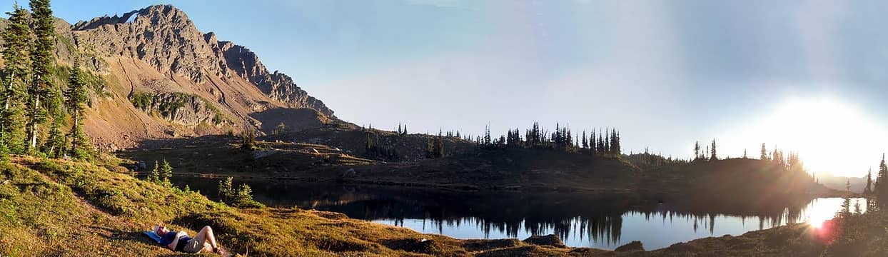
modern napping at lake grace below snowgrass mountain
i may not be the smartest guy, but all the information we had for this trip was either conflicting, confusing or not very useful. i was a little worried about the route and how difficult it was, some said class 4. fortunately my buddies had done this trip recently and filled me in. essentially they said ignore the beta, the beta gave too much info, and just go the obvious way and it is walk-up. my buddies were right. modern and i drove highway 2 ~14 miles east stevens pass and turned on the white pine creek road. we fortunately went the correct way at the many junctions, crossed the bridge a couple miles after turning onto the whitepine creek road, driving by the cascade meadows church camp(near where we parked for our winter attempt of middle chiwaukum) and onto the trailhead at the end of the road. since we were just going to walk to camp, we got an after lunch start and took our time as we walked up the whitepine trail (past the the signed trail junction with the wildhorse trail) to the meadows on the west side of big chiwaukum. there is no sign at this junction. one fork heads slightly up and to the left toward the meadows, the other fork goes a little down and right(the main trail). both had equal amounts of wear. we headed up into the open meadows. we crossed the creek angling se to head up an easy but steep gully(the second major gully, although many of the gullies would probably go) to attain and cross big chiwaukum's west ridge and then traversed over to lake grace. great camp - water, scenery, flat place to sleep.
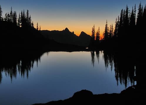
twilight at lake grace with bulls tooth in the background
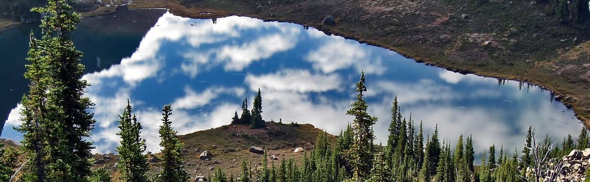
we switched on the radio. the plan was for iron to meet us after his job interview. we went to sleep without hearing from him. day two's agenda was rather ambitious, scramble big chiwaukum, hike up snowgrass and then tag frosty. with the short daylight hours in the fall, we would need to get an early start to do this. as often happens, plans change. since we needed to join up with iron, we decided to sleep in. checking the radio every hour, we made contact with iron at 8:00am. after waiting a while, we decided to walk the few hundred feet to the ridge where we would have better radio reception, could hopefully see iron and we would all be at the beginning of the route.
camp at lake grace
camp at lake grace
after an hour or so, we realized iron was on the north side of the ridge(we were on the south). new plan, iron would try to scramble the north ridge and we up the south so we could all meet on the summit. modern and i scrambled up the easy west ridge
modern on the way up big chiwaukum
and then gained the south east ridge. we mostly traversed ~10' below the se ridge on its west side and then came to the false summit. there were a lot of little bumps on the ridge. how did we know it was the false summit, the true summit or none of the above? the bump that proved to be the false summit had a ramp that both modern and i spotted right away that looked like it was the right way to go. the bump looked like a class 4 challenge to get up and over. so what did we choose to do? instead going straight to the ramp, we walked over to base of the class 4 scramble and looked at it. fay's t/r mentioned taking an hour on the false summit and and modern said none of the bumps we had come to could possibly have taken her an hour getting over. just as he said that, i looked down at the ramp again and spotted the cairn. its rocks where black which made it fade into the background and hard to see. we immediately walked down to the ramp.
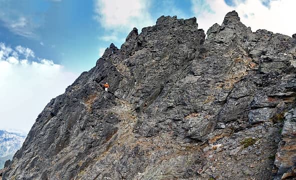
modern on the ramp around big chiwaukum's false summit
i added a white rock to the top of the cairn and we continued past the false summit and across a gully or two and then headed up toward the ridge. i immediately spotted the class 4 fault/dike that max and summitpost had talked about. it looked pretty straightforward. but before i even stepped up to it, modern had walked up to the ridge the easy class 2 way that no one had spoke of, just a few feet north of the summit. i scrambled up the easy rock step to the summit and found the register - bingo. we kicked back on the summit and relaxed waiting for iron.
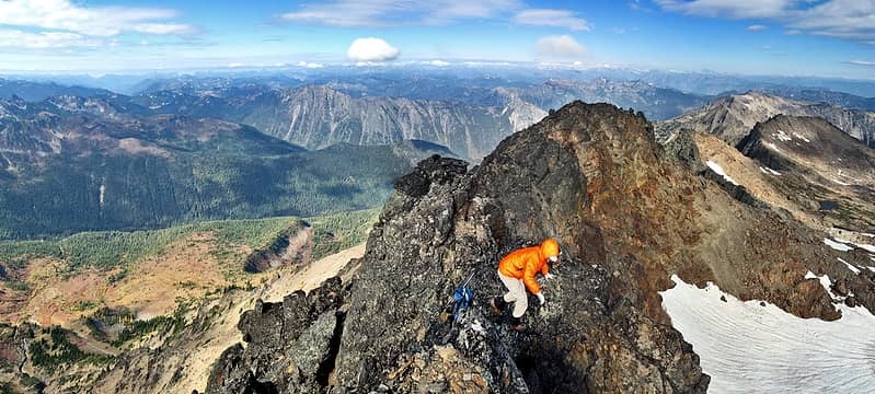
looking down at modern from the summit of big chiwaukum
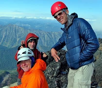
his route did not go as easy. after a while we see him get cliffed out on the bump just north of the summit. he only needed a couple of feet more and the terrain would have eased up. unfortunately the mountain did not offer that to him. now he had a choice of reversing his route and probably not summiting or descend some super scary and dangerously exposed downslopey rocks on the east side of that bump and then hope he can find a way to the notch just north of us. it looked to me like it was too hard, but iron meticulously worked the route to success. just before iron makes it, we hear voices from below. another party of two. this summit only sees a couple of parties a year, so it surprised us. tim and his buddy were strong climbers and we all had a good chat on the summit.
summit of big chiwaukum
they had come up the west face/gullies. they and iron were quite pleased when i led us all back the easy class two route. tim and his friend boogied ahead and ran over and tagged snowgrass mt.
easy scrambling down big chiwaukum - snowgrass(with the snowfield), upper lake grace(by the scramblers) and lower lake grace(bottom middle) - the weather is turning
with the weather deteriorating, with daylight dwindling and not wanting to run, we decided to bail on snowgrass and frosty. we went back down to camp, cooked some lunch and made plans for walking out on the old abandoned lake grace trail. we walked to the smaller and most sw of the lake grace lakes and followed and lost the trail downhill and then picked up the trail again after it descended its steepest part. we eventually connected up with the whitepine trail and walked it back to the car. tim and his buddy literally ran right past us. this was not something that happens to iron, but since he was doing a leisurely trip with us old-timers, so he let it go. we walked the last couple of miles by headlamp. no snowgrass, no frosty, but a great big fun chiwaukum day. :>) references: smoot, fay p t/r , summitpost, (none were a huge help), phone call to max & lorna(big help) equipment:helmets(used them because we had them with us) big chiwaukum stats: 19.77 mi 5992' gain overall 6:04 car to lake grace 7.71 mi 3738' gain car to lake grace 0:15 lake grace to 6625 saddle 0:57 wait at 6625 saddle 1:56 6625 saddle to summit 1:26 summit stay 6:35 summit to car 10.08 mi 2269' gain lake grace to summit to car short and sweet directions: hike whitepine trail to meadow just n of big chiwaukum's w ridge. go se across meadows and attain big chiwaukum's w ridge. go up w ridge to se ridge. follow se ridge usually ~10' below ridge on west side. just before the summit, traverse down and around west side on cairned ramp. follow obvious terrain back up to ridge top a few feet north of true summit. easy 8' scramble to summit. the whole route is class 2, with the final move to attain the summit maybe class 3. seeing how many people have turned this into class 3 or 4, it must not always be that easy of route finding i guess. we definitely had no problems.
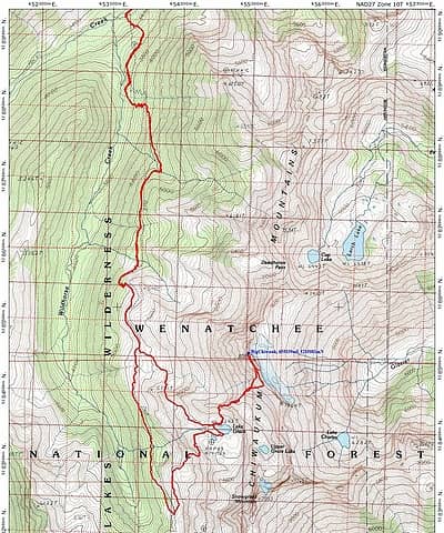
big_chiwaukum_route.JPG

Back to top Reply to topic Reply with quote Send private message
Bryan K
Shameless Peakbagger


Joined: 29 Sep 2005
Posts: 5129 | TRs | Pics
Location: Alaska
Bryan K
Shameless Peakbagger
PostSun Oct 31, 2010 12:00 am 
Awesome info on this route! I was looking at this on my maps recently and hadn't thought it'd be possible with beta that I was finding on the internet. Thanks for clearing some things up for me biggrin.gif

Back to top Reply to topic Reply with quote Send private message
iron
Member
Member


Joined: 10 Aug 2008
Posts: 6392 | TRs | Pics
Location: southeast kootenays
iron
Member
PostSun Oct 31, 2010 12:45 pm 
b00 wrote:
camp at lake grace
camp at lake grace
nice shot! i won't even go into my dilemmas of meeting up with hollywood and modern. let's just say it involved a very faint bootpath, complete darkness, and waking up the next morning thinking, and convincing myself, that i was somewhere i was not. dizzy.gif

Back to top Reply to topic Reply with quote Send private message
the Zachster
Member
Member


Joined: 17 Jan 2007
Posts: 4776 | TRs | Pics
Location: dog training
the Zachster
Member
PostSun Oct 31, 2010 1:03 pm 
Great trip report, and the photo of Camp at Lake Grace is absolutely gorgeous!!! up.gif up.gif up.gif

"May I always be the kind of person my dog thinks I am"
Back to top Reply to topic Reply with quote Send private message
   All times are GMT - 8 Hours
 Reply to topic
Forum Index > Trip Reports > big chiwaukum 10-6 + 10-7-2010
  Happy Birthday Eric, dean brittain!
Jump to:   
Search this topic:

You cannot post new topics in this forum
You cannot reply to topics in this forum
You cannot edit your posts in this forum
You cannot delete your posts in this forum
You cannot vote in polls in this forum