| Previous :: Next Topic |
| Author |
Message |
Backpacker Joe
Blind Hiker


Joined: 16 Dec 2001
Posts: 23956 | TRs | Pics
Location: Cle Elum |
I decided to checkout Money Creek and the new repairs. Very nice work.
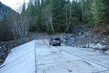 New washout fix looking West 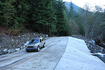 New washout fix looking East 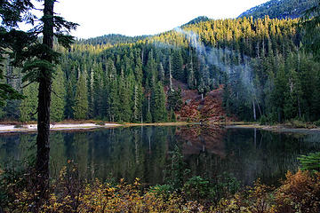 Elizabeth lake 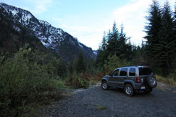 Roads end 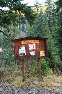 Lake sign
"If destruction be our lot we must ourselves be its author and finisher. As a nation of freemen we must live through all time or die by suicide."
Abraham Lincoln
"If destruction be our lot we must ourselves be its author and finisher. As a nation of freemen we must live through all time or die by suicide."
Abraham Lincoln
|
| Back to top |
  
|
|
Sore Feet
Member

Joined: 16 Dec 2001
Posts: 6305 | TRs | Pics
Location: Out There, Somewhere |
That's quite a substantial repair considering that road doesn't really go anywhere.
|
| Back to top |
|
|
Backpacker Joe
Blind Hiker
Joined: 16 Dec 2001
Posts: 23956 | TRs | Pics
Location: Cle Elum |
| Sore Feet wrote: | | That's quite a substantial repair considering that road doesn't really go anywhere. |
I thought the same thing Bryan. Weird.
"If destruction be our lot we must ourselves be its author and finisher. As a nation of freemen we must live through all time or die by suicide."
Abraham Lincoln
"If destruction be our lot we must ourselves be its author and finisher. As a nation of freemen we must live through all time or die by suicide."
Abraham Lincoln
|
| Back to top |
|
|
GeoHiker
Rocky Walker
Joined: 26 Feb 2005
Posts: 6033 | TRs | Pics
Location: Off the Deep End |
|
GeoHiker
Rocky Walker
|
 Tue Nov 09, 2010 1:29 am |
|
|
I've wondered about that too on another post and never got a response. I wonder if there's an existing agreement with the mines in that area to provide access. Similar to the MFK road and the fiasco there with private ownership?
Or, East access to the Tolt Res. watershed that must stay open? That looks like a ton of money. I'm happy to see they (FS, County) has money to waste like this. Makes me more than happy to jump on the bandwagon for additional access fees!...... 
You call some place paradise, kiss it goodbye......Eagles
You call some place paradise, kiss it goodbye......Eagles
|
| Back to top |
|
|
Backpacker Joe
Blind Hiker
Joined: 16 Dec 2001
Posts: 23956 | TRs | Pics
Location: Cle Elum |
Could they get to the Tolt from Money Creek? Sure but it would take a bull dozer. This is the end of the road.
Roads end
"If destruction be our lot we must ourselves be its author and finisher. As a nation of freemen we must live through all time or die by suicide."
Abraham Lincoln
"If destruction be our lot we must ourselves be its author and finisher. As a nation of freemen we must live through all time or die by suicide."
Abraham Lincoln
|
| Back to top |
|
|
wolfs
Member

Joined: 07 Oct 2004
Posts: 302 | TRs | Pics
|
|
wolfs
Member
|
Tue Nov 09, 2010 12:25 pm |
|
|
What is the Money Ck road like in general, to get to the end? 4WD and or high clearance recommended at any point?
|
| Back to top |
|
|
Backpacker Joe
Blind Hiker
Joined: 16 Dec 2001
Posts: 23956 | TRs | Pics
Location: Cle Elum |
| wolfs wrote: | | What is the Money Ck road like in general, to get to the end? 4WD and or high clearance recommended at any point? |
There are two places along the road that Id suggest a high clearance vehicle. One of the two almost required four wheel drive is was so crappy.
"If destruction be our lot we must ourselves be its author and finisher. As a nation of freemen we must live through all time or die by suicide."
Abraham Lincoln
"If destruction be our lot we must ourselves be its author and finisher. As a nation of freemen we must live through all time or die by suicide."
Abraham Lincoln
|
| Back to top |
|
|
GeoHiker
Rocky Walker

Joined: 26 Feb 2005
Posts: 6033 | TRs | Pics
Location: Off the Deep End |
|
GeoHiker
Rocky Walker
|
Tue Nov 09, 2010 5:23 pm |
|
|
| Backpacker Joe wrote: | Could they get to the Tolt from Money Creek? Sure but it would take a bull dozer. This is the end of the road.
Roads end |
I'm not sure where the official boundary to the Res. is but looking at TOPO the end of the road is inside the watershed and 3/4 of Lk. Elizabeth? Hmmm, I don't recall seeing any death signs near there?
I know the road doesn't continue, but 6540 would provide access to the upper east end of the watershed. Only thing I can come up with why that road gets $$$ dumped in there on a regular basis and other roads go to rot or decommissioned. Maybe all those crazy mine explorers wield more clout than we thought!....  Is the concrete up and down the county repair? Wow, that must have cost some big $$$. That's one of the largest I've seen. BPJ, do you think I could get my Honda up there? Thinking I might run up there in the next couple days before it gets socked in with snow for the winter.
You call some place paradise, kiss it goodbye......Eagles
You call some place paradise, kiss it goodbye......Eagles
|
| Back to top |
|
|
H. Hound
Member

Joined: 09 May 2003
Posts: 1205 | TRs | Pics
Location: Exit 32 |
|
H. Hound
Member
|
Tue Nov 09, 2010 5:35 pm |
|
|
Yer going to want more ground clearance than a Miata above the switchbacks.
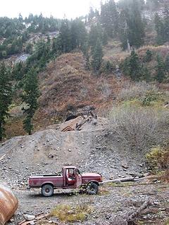
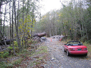 Ya it doesn't take much. This is just before the San Francisco\Apex mine area.
|
| Back to top |
|
|
Backpacker Joe
Blind Hiker
Joined: 16 Dec 2001
Posts: 23956 | TRs | Pics
Location: Cle Elum |
Geo, honda what exactly? Probably, there are two spots that youd have to be very careful placing your tires correctly to get by without dragging your undercarriage to badly.
Thanks one of the spots Im talking about. Thanks H.
"If destruction be our lot we must ourselves be its author and finisher. As a nation of freemen we must live through all time or die by suicide."
Abraham Lincoln
"If destruction be our lot we must ourselves be its author and finisher. As a nation of freemen we must live through all time or die by suicide."
Abraham Lincoln
|
| Back to top |
|
|
GeoHiker
Rocky Walker
Joined: 26 Feb 2005
Posts: 6033 | TRs | Pics
Location: Off the Deep End |
|
GeoHiker
Rocky Walker
|
Tue Nov 09, 2010 6:14 pm |
|
|
Thanks, HH that looks a bit sketchy for my Civic. BPJ, I thought you've seen my 4x4 Civic with the 36" Super Swampers!....
Ground clearance sucks big time and the underneath looks like someone went nuts with a hammer, so it's not a stranger to rough roads. I just repaired a gas tank leak (again) last week, so I try and stay clear of the jagged rocks. I can see jagged chunky rocks, so looks like I'll have to drive my truck.
So $$$ was spent by the county to go what 2 miles then you come to the FS portion of the road and you have to have 4x4 or high clearance? Did the FS portion of the road even get worked on?
You call some place paradise, kiss it goodbye......Eagles
You call some place paradise, kiss it goodbye......Eagles
|
| Back to top |
|
|
Gamuru
Cartographile
Joined: 20 Oct 2010
Posts: 503 | TRs | Pics
Location: Granite Falls |
|
Gamuru
Cartographile
|
Tue Nov 09, 2010 6:22 pm |
|
|
Using the right tool for the job...
 Damon and Pythias Mine.jpg 
Don
"The definition of a mine is a hole in the ground that belongs to a liar."
~Mark Twain
Don
"The definition of a mine is a hole in the ground that belongs to a liar."
~Mark Twain
|
| Back to top |
|
|
Matt
Tea, Earl Grey, Hot

Joined: 30 Jan 2007
Posts: 4308 | TRs | Pics
Location: Shoreline |
|
Matt
Tea, Earl Grey, Hot
|
Wed Nov 10, 2010 12:19 am |
|
|
I've never seen a washout area covered in concrete like that.
Think it will hold?
As beacons mountains burned at evening. J.R.R. Tolkien
As beacons mountains burned at evening. J.R.R. Tolkien
|
| Back to top |
|
|
Scrooge
Famous Grouse

Joined: 16 Dec 2001
Posts: 6966 | TRs | Pics
Location: wishful thinking |
|
Scrooge
Famous Grouse
|
Wed Nov 10, 2010 1:42 am |
|
|
That's by far the biggest I've seen, but they're not that uncommon. I think the biggest one I know about is on the road in to the Foss Lakes trailhead, where it crosses Burn Creek, a pretty good sized tributary of the Foss. However, that one is a year-round ford, not just a precaution.
There were several, more modest ones, up on that section of the Illabot Creek Road that's proposed for decommissioning.
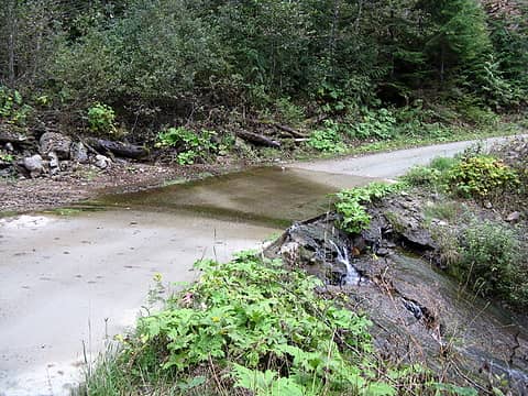 Concrete ford on Illabot Creek Road
Something lost behind the ranges. Lost and waiting for you....... Go and find it. Go!
Something lost behind the ranges. Lost and waiting for you....... Go and find it. Go!
|
| Back to top |
|
|
GeoHiker
Rocky Walker

Joined: 26 Feb 2005
Posts: 6033 | TRs | Pics
Location: Off the Deep End |
|
GeoHiker
Rocky Walker
|
Wed Nov 10, 2010 2:19 am |
|
|
The one near the Foss Lks TH went in long long ago. Mid 70's if I remember right. Back when someone had the common sense to know that it didn't provide salmon habitat. That area used to wash out almost yearly. It's held up well, although early spring the water is a bit deep!......
You call some place paradise, kiss it goodbye......Eagles
You call some place paradise, kiss it goodbye......Eagles
|
| Back to top |
|
|
|
|


