| Previous :: Next Topic |
| Author |
Message |
Scrooge
Famous Grouse


Joined: 16 Dec 2001
Posts: 6966 | TRs | Pics
Location: wishful thinking |
|
Scrooge
Famous Grouse
|
 Fri Aug 10, 2012 10:17 am |
|
|
Some geologists, including J Harlen Bretz and Bruce Bjornstad, have concluded that Northrup Canyon is geologically recent, carved by the Missoula Floods during the last Ice Age, 15,000 to 20,000 years ago.
I think it's more likely that Northrup Canyon was carved by Northrup Creek, over the course of a million years (or more), in the same way that dozens of other tributaries to the Columbia River carved their canyons.
One thing that influenced the thinking of Bretz and Bjornstad is the fact that Northrup Creek now flows into Banks Lake, in the Grand Coulee, and the Grand certainly was cut by the Missoula Floods; it wasn't there, 20,000 years ago.
Another thing may have been the odd fact that Northrup Creek appears to start from two springs at the exact head of Northrup Canyon. Perhaps the canyon and the stream are the same age?
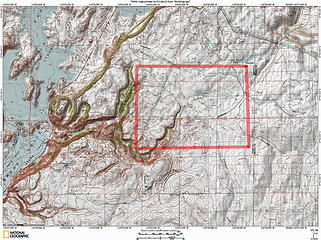 Northrup Canyon - 'apparent' headwaters area outlined in red. 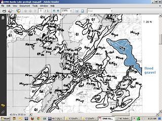 Detail from geo quad, Banks Lake. 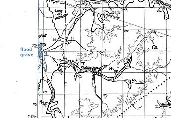 Detail from geo quad, Coulee Dam. 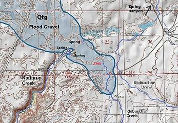 Annotated map of Northrup Creek headwaters area, with Missoula Floods' gravel deposit drawn in. 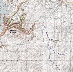 Northrup Canyon and Klobuschar Creek.  But, what happened at the downstream end of Northrup Creek is tougher. It'll be the subject of a separate essay.
Something lost behind the ranges. Lost and waiting for you....... Go and find it. Go!
Something lost behind the ranges. Lost and waiting for you....... Go and find it. Go!
|
| Back to top |
  
|
|
lookout bob
WTA proponent.....

Joined: 12 Apr 2005
Posts: 3043 | TRs | Pics
Location: wta work while in between lookouts |
|
lookout bob
WTA proponent.....
|
Sat Aug 11, 2012 11:29 am |
|
|
Scrooge....thanks for the continuing reports on Bretz flood stuff. Interesting reads indeed. Northrup is an awesome hike and I wondered about its formation too...didn't seem part of the whole general floods picture. Keep them cards and letters comin'..... 
"Altitude is its own reward"
John Jerome ( from "On Mountains")
"Altitude is its own reward"
John Jerome ( from "On Mountains")
|
| Back to top |
|
|
mike
Member
Joined: 09 Jul 2004
Posts: 6397 | TRs | Pics
Location: SJIsl |
|
mike
Member
|
Sat Aug 11, 2012 12:35 pm |
|
|
Perhaps it flowed north before the flood rerouted the channel?
|
| Back to top |
|
|
Scrooge
Famous Grouse

Joined: 16 Dec 2001
Posts: 6966 | TRs | Pics
Location: wishful thinking |
|
Scrooge
Famous Grouse
|
Sat Aug 11, 2012 2:00 pm |
|
|
Perhaps, Mike, but that would leave the problem of, "Where did the water come from to charge those springs at the head of Northrup Canyon?"
Or. turning it around, wasn't it convenient to have that canyon there, just when some water turned up that needed a place to run?  Sorry.
But seriously, I think it's actually more likely the creek in Klobuschar Draw was also a tributary of Northrup Creek, rather than flowing down Spring Canyon (which it does, now). Sorry.
But seriously, I think it's actually more likely the creek in Klobuschar Draw was also a tributary of Northrup Creek, rather than flowing down Spring Canyon (which it does, now).
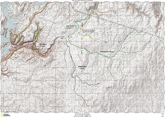 Annotated map of the Northrup Canyon - Klobuschar Creek area.  I consider myself a disciple of Bretz: I look at what's there and then try to figure out what would work, what makes sense. ...... But, they were teaching Uniformitarianism when I took geology in college. It made sense, then, and it still does, for most things. I consider myself a disciple of Bretz: I look at what's there and then try to figure out what would work, what makes sense. ...... But, they were teaching Uniformitarianism when I took geology in college. It made sense, then, and it still does, for most things.
Something lost behind the ranges. Lost and waiting for you....... Go and find it. Go!
Something lost behind the ranges. Lost and waiting for you....... Go and find it. Go!
|
| Back to top |
|
|
HitTheTrail
Member

Joined: 30 Oct 2007
Posts: 5455 | TRs | Pics
Location: 509 |
| Scrooge wrote: | | But, they were teaching Uniformitarianism when I took geology in college. |
Don't feel bad. Plate tectonics was not accepted by mainstream geologists until the mid1970's after the Glomar Challenger got mirror image magnetic data from spreading centers. That was after I got my undergraduate degree in geology! Good insights in the TR. Keep them coming.
|
| Back to top |
|
|
|
|
You cannot post new topics in this forum
You cannot reply to topics in this forum
You cannot edit your posts in this forum
You cannot delete your posts in this forum
You cannot vote in polls in this forum
|
Disclosure: As an Amazon Associate NWHikers.net earns from qualifying purchases when you use our link(s). |


