| Previous :: Next Topic |
| Author |
Message |
beaudaddy
Coast To Cascades


Joined: 25 Feb 2010
Posts: 401 | TRs | Pics
Location: Tulalip, WA |
|
beaudaddy
Coast To Cascades
|
 Mon Jun 20, 2011 9:34 am |
|
|
Solid effort guys on what looked like some nasty conditions... Looks like you guys had some good attitudes though!
Hey Craig, you say that microspikes and/or crampons are highly recommended. I've never been up there before, so I do not know first hand how steep that permanent snowfield is around 5,400'. From google earth and the topo it looks like maybe there isn't much run out before a large cliff below.
For anyone going up there in the next couple weeks, I think crampons would be a really good idea to have in the pack even if they are not needed. I've crossed steep snowfields when it was bootable, but on the decent it froze over... that spot doesn't look like a place you would want to fall. I know you can self arrest with an axe, but no reason to increase the risk to fall.
I know you guys had crampons, so this comment is not directed to you guys, plus I know you guys would probably agree.
The comment is more for the guy who goes "light" unprepared and tries to cross the "maybe" icy snowfield on the decent and cannot get any traction.
I attached a picture of the spot I'm talking about. Like I said, I've never been up there so I drew the redline where I think the west ridge route goes. Nobody print this photo and use...  Also, I would be down to do this one with you guys... maybe when the bushwacking isn't so wet though...
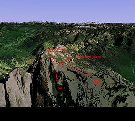 Index West Ridge Route
|
| Back to top |
  
|
|
Schroder
Member

Joined: 26 Oct 2007
Posts: 6722 | TRs | Pics
Location: on the beach |
|
Schroder
Member
|
Mon Jun 20, 2011 9:57 am |
|
|
No thanks. Been there done that.
It looks like the east gully is becoming more attractive again.
|
| Back to top |
|
|
Gimpilator
infinity/21M

Joined: 12 Oct 2006
Posts: 1684 | TRs | Pics
Location: Edmonds, WA |
| summithound wrote: | | Did you guys park at the closed gate on the Proctor Creek Road and bike to the trailhead? I heard you mention in your video that your intent was to follow the Persis route on the descent ... |
Yes we used bikes. Otherwise it would be 20+ miles on foot. The mention of the traverse was really just a joke. It would be nice to if you could only schwack one way.
For everyone else, Beau is right. There are some very steep slopes on this peak, even before the saddle. Some have bad run-out and some have no-run out if you know what I mean. Bring traction devices, Yak tracks don't count.
|
| Back to top |
|
|
summithound
Climbing Connoisseur
Joined: 26 Jul 2004
Posts: 1766 | TRs | Pics
Location: Everett, WA |
|
summithound
Climbing Connoisseur
|
Mon Jun 20, 2011 10:20 am |
|
|
Awesome. Looks like there is some interest here in putting together a trip for this weekend. If the weather holds I'll probably throw up an ad in Partners.
Pain is just weakness leaving the body.
Pain is just weakness leaving the body.
|
| Back to top |
|
|
Redwic
Unlisted Free Agent

Joined: 23 Feb 2009
Posts: 3292 | TRs | Pics
Location: Going to the Prom(inence) |
|
Redwic
Unlisted Free Agent
|
Mon Jun 20, 2011 11:58 pm |
|
|
Beau (et al)-
We each brought traction devices. I used my microspikes on the descent of the steep forest and was very glad that I did, but Adam did not. We did not reach the snowfield, so I could not describe the current conditions there. Crampons strongly advised. My guess is that the snowfield is not icy, yet, but there is no way to know for certain until/unless somebody goes back soon to check it out!
60 pounds lighter but not 60 points brighter.
60 pounds lighter but not 60 points brighter.
|
| Back to top |
|
|
Man-inna-hillz
Member
Joined: 25 Aug 2005
Posts: 286 | TRs | Pics
Location: Berkeley, CA |
So can someone describe the basic West Face route and approach up Index, or link to a route description? I gather it involves Proctor Road, bicycles and some bushwhacking, but I would be really interested to get a detailed approach and route description. The Main Peak of Index rises up above our S. Fork Skyko cabin like a taunting middle finger to the Index proper, and I've always wanted to do that route, brushy or no.
The God of language forgives all crimes.
-W.H. Auden
The God of language forgives all crimes.
-W.H. Auden
|
| Back to top |
|
|
Man-inna-hillz
Member
Joined: 25 Aug 2005
Posts: 286 | TRs | Pics
Location: Berkeley, CA |
Is it easier to forgo all of that nasty looking brush and slide alder as seen in the bushwhack video, head up to the Persis Summit, and then traverse the Persindex ridgeline? I suppose that would be a pretty epic day.
The God of language forgives all crimes.
-W.H. Auden
The God of language forgives all crimes.
-W.H. Auden
|
| Back to top |
|
|
lopper
off-route

Joined: 22 Jan 2002
Posts: 845 | TRs | Pics
|
|
lopper
off-route
|
Tue Jun 21, 2011 11:27 pm |
|
|
In June of 1979, spur #140 was driveable by VW beetle, to within 50 yards of the terminus.
Ice axes were, and are, a very good idea on those upper snow slopes.
A clear day not only works for views, but makes navigating the brushy areas on the way up to the ridge less confusing.
 71RecMap 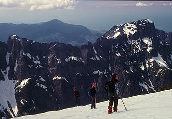 79Index4 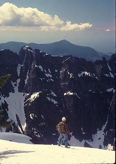 79Index1  79Index3
|
| Back to top |
|
|
puzzlr
Mid Fork Rocks

Joined: 13 Feb 2007
Posts: 7220 | TRs | Pics
Location: Stuck in the middle |
|
puzzlr
Mid Fork Rocks
|
Tue Jun 21, 2011 11:33 pm |
|
|
lopper - so cool when you scan in your old photos. Too bad they were so expensive to take in the old film days, and I had so little money. I could have had a much better set of photos from the late 70s and 80s.
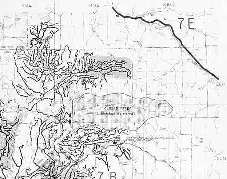
Man-inna-hillz - one of the cool things about Index is that there is no standard route from the West, even though once you get near the peak that's the easiest direction. There are several ways of approaching the west ridge, all of which have pros and cons. I have not seen the Tolt valley road being used so much until this year, at least based on the trip reports. I think we're seeing why now. Below is the route that we took in 2007. The road part was ok (then), but I can't recommend the half mile traverse across the talus before reaching the gully that goes up to the PersIndex meadows. I'd love the hear from someone trying the Anderson Creek approach - that would be a wild bushwhack!
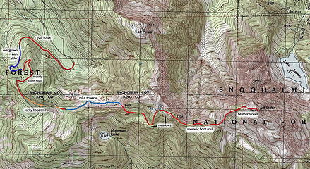 Map of the route we took. It's longer than bushwhacking directly up the E side of Persis Basin, but more predictable.
|
| Back to top |
|
|
Redwic
Unlisted Free Agent
Joined: 23 Feb 2009
Posts: 3292 | TRs | Pics
Location: Going to the Prom(inence) |
|
Redwic
Unlisted Free Agent
|
Wed Jun 22, 2011 5:48 am |
|
|
| puzzlr wrote: | Below is the route that we took in 2007. The road part was ok (then), but I can't recommend the half mile traverse across the talus before reaching the gully that goes up to the PersIndex meadows. I'd love the hear from someone trying the Anderson Creek approach - that would be a wild bushwhack!
Map of the route we took. It's longer than bushwhacking directly up the E side of Persis Basin, but more predictable. |
Out of curiosity... How many miles (estimated) was that trip, one-way? Also, what time of year did that trip occur? (With snow? Without snow?)
60 pounds lighter but not 60 points brighter.
60 pounds lighter but not 60 points brighter.
|
| Back to top |
|
|
Gimpilator
infinity/21M
Joined: 12 Oct 2006
Posts: 1684 | TRs | Pics
Location: Edmonds, WA |
| lopper wrote: | 79Index3 |
Awesome stuff! Thanks for sharing.
|
| Back to top |
|
|
beaudaddy
Coast To Cascades
Joined: 25 Feb 2010
Posts: 401 | TRs | Pics
Location: Tulalip, WA |
|
beaudaddy
Coast To Cascades
|
Wed Jun 22, 2011 4:10 pm |
|
|
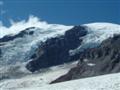
Awesome Lopper! I love when you share your photos.
Here is a photo I took yesterday from Persis. Persis has a great vantage point for the west ridge route.
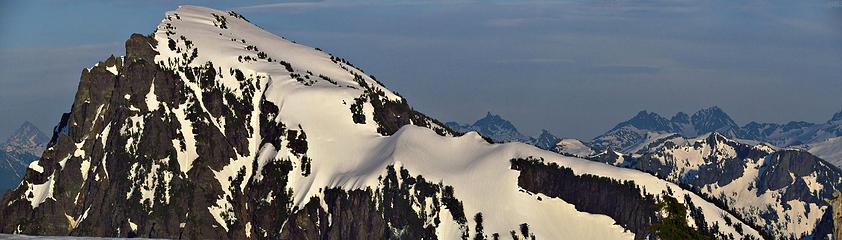 Main summit of Mt Index
|
| Back to top |
|
|
summithound
Climbing Connoisseur
Joined: 26 Jul 2004
Posts: 1766 | TRs | Pics
Location: Everett, WA |
|
summithound
Climbing Connoisseur
|
Wed Jun 22, 2011 4:15 pm |
|
|
Thanks for the recent picture.  For a mountain that assumes such a commanding position over Highway 2, I feel it sees relatively few ascents. Here's hoping for a slightly better weather forecast for the west side this weekend. For a mountain that assumes such a commanding position over Highway 2, I feel it sees relatively few ascents. Here's hoping for a slightly better weather forecast for the west side this weekend. 
Pain is just weakness leaving the body.
Pain is just weakness leaving the body.
|
| Back to top |
|
|
puzzlr
Mid Fork Rocks
Joined: 13 Feb 2007
Posts: 7220 | TRs | Pics
Location: Stuck in the middle |
|
puzzlr
Mid Fork Rocks
|
Wed Jun 22, 2011 9:07 pm |
|
|
| Redwic wrote: | | Out of curiosity... How many miles (estimated) was that trip, one-way? Also, what time of year did that trip occur? (With snow? Without snow?) |
I don't usually measure miles. It took 12 hours car-to-car. We did it on a glorious September day with only a few patches of snow remaining on the upper mountain.
|
| Back to top |
|
|
Gimpilator
infinity/21M
Joined: 12 Oct 2006
Posts: 1684 | TRs | Pics
Location: Edmonds, WA |
Thanks for the awesome route photo Beau. Looks like there's still some considerable cornices up there. I remember a few years ago, seeing a giant cornice near the summit.
|
| Back to top |
|
|
|
|


