| Previous :: Next Topic |
| Author |
Message |
Tom_Sjolseth
Born Yesterday


Joined: 30 May 2007
Posts: 2652 | TRs | Pics
Location: Right here. |
BirdDog and I linked up for a two-day trip to climb Ruth Mountain and Icy Peak in the North Cascades yesterday.
The forecast called for mostly sunny skies yesterday after morning clouds. With this forecast, we decided we would bivy on the summit of Ruth on day 1, then head to Icy and out on day 2. At the last minute, I made the [genius] executive decision to leave the tent behind. Light and fast!  The road to Hannegan Pass is in OK condition until about 1/3 mile before the parking lot, where the road is impassable due to avalanche debris. There isn't much room to turn a large vehicle around here, so heads up.
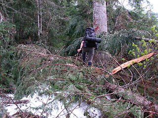
We left the car just before 10AM under cloudy skies and zero precipitation. The trail up to Hannegan Pass is in abysmal shape due to numerous enormous avalanches that have obliterated the trail (and everything surrounding it). At times, old growth had been uprooted and many of the avalanches went down to the soil and talus. The trail crews have a ton of work ahead of them on this stretch of trail, and I expect it will take some time for the trail to be restored to its previous condition.
Instead of going up to Hannegan Pass, there is so much snow up there right now that we headed straight up the headwaters of Ruth Creek to a pass S of Pt 5810. Easy step-kicking in surprisingly consolidated snow allowed us to gain the ridge just after 1:30PM. Around this time, visibility quickly began to deteriorate, and within 5 minutes of arriving on the ridge, we couldn't see anything and it began to drizzle. No problem.. we'll just hang out and wait for the marine layer to burn off and continue up to the summit when it does. Well, it didn't.
After laying around in full Gore-Tex for about 4 hours waiting for things to improve, we decided we needed to call it all off due to the fact that some genius decided that leaving the tent at home was a good idea. So we headed down. After dropping about 2000', within about 2 miles of the TH, the birds started chirping and the skies began to clear.
It took little time for Geoff and I to agree that heading back up was the right thing to do. We headed back up into the basin below Hannegan Pass and set up camp for the night hoping this was the last of the rain. It was.
The road to Hannegan Pass is in OK condition until about 1/3 mile before the parking lot, where the road is impassable due to avalanche debris. There isn't much room to turn a large vehicle around here, so heads up.
We left the car just before 10AM under cloudy skies and zero precipitation. The trail up to Hannegan Pass is in abysmal shape due to numerous enormous avalanches that have obliterated the trail (and everything surrounding it). At times, old growth had been uprooted and many of the avalanches went down to the soil and talus. The trail crews have a ton of work ahead of them on this stretch of trail, and I expect it will take some time for the trail to be restored to its previous condition.
Instead of going up to Hannegan Pass, there is so much snow up there right now that we headed straight up the headwaters of Ruth Creek to a pass S of Pt 5810. Easy step-kicking in surprisingly consolidated snow allowed us to gain the ridge just after 1:30PM. Around this time, visibility quickly began to deteriorate, and within 5 minutes of arriving on the ridge, we couldn't see anything and it began to drizzle. No problem.. we'll just hang out and wait for the marine layer to burn off and continue up to the summit when it does. Well, it didn't.
After laying around in full Gore-Tex for about 4 hours waiting for things to improve, we decided we needed to call it all off due to the fact that some genius decided that leaving the tent at home was a good idea. So we headed down. After dropping about 2000', within about 2 miles of the TH, the birds started chirping and the skies began to clear.
It took little time for Geoff and I to agree that heading back up was the right thing to do. We headed back up into the basin below Hannegan Pass and set up camp for the night hoping this was the last of the rain. It was.
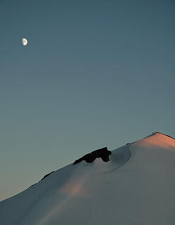
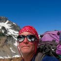
 Views from camp.  Just above camp.  On the NNE Ridge of Ruth, looking E.  Geoff on easy snow.  Redoubt dominates.  A neat rock formation below the summit of Ruth.  Geoff on his way up.  BirdDog just below the summit.  BirdDog approaches the summit. The wild Chilliwack River valley behind.  The Ruth Mountain bench mark.  Views from the summit. Blum, Hagan, and Icy.  The Northern Pickets.  Geoff with Shuksan's Price Glacier behind.  Icy Peak and Seahpo.  14 labels The Southern Pickets with Ragged Ridge in the background.  Unknown animal tracks on the descent (wolverine??).
|
| Back to top |
  
|
|
Redwic
Unlisted Free Agent

Joined: 23 Feb 2009
Posts: 3292 | TRs | Pics
Location: Going to the Prom(inence) |
|
Redwic
Unlisted Free Agent
|
 Tue Jun 21, 2011 8:05 pm |
|
|
Great job, you guys!!!
Holy cow... I thought I was the only person left who uses those same bright yellow LEKI poles!!! 
60 pounds lighter but not 60 points brighter.
60 pounds lighter but not 60 points brighter.
|
| Back to top |
|
|
Don
Member

Joined: 25 Apr 2005
Posts: 2013 | TRs | Pics
Location: Fairwood, WA |
|
Don
Member
|
Tue Jun 21, 2011 8:13 pm |
|
|
Awesome! Thanks for the heads up on the TR!  Don
Don
|
| Back to top |
|
|
silence
Member

Joined: 25 Apr 2005
Posts: 4420 | TRs | Pics
|
|
silence
Member
|
Tue Jun 21, 2011 8:16 pm |
|
|
fun climb .. one of our faves -- yeah the views are to die for up there .. i'm pretty sure we could see challenger too .. funny we were just wondering about it over the weekend .. sounds like a lot of work getting up there right now with all the avy debris ..
glad you got out!
PHOTOS
FILMS
Keep a good head and always carry a light bulb. Bob Dylan
PHOTOS
FILMS
Keep a good head and always carry a light bulb. Bob Dylan
|
| Back to top |
|
|
iron
Member

Joined: 10 Aug 2008
Posts: 6392 | TRs | Pics
Location: southeast kootenays |
|
iron
Member
|
Tue Jun 21, 2011 10:03 pm |
|
|
fast n light rocks!
thanks for the beta on the hannegan pass trail as that solidifies july's plans for me...
|
| Back to top |
|
|
puzzlr
Mid Fork Rocks

Joined: 13 Feb 2007
Posts: 7220 | TRs | Pics
Location: Stuck in the middle |
|
puzzlr
Mid Fork Rocks
|
Tue Jun 21, 2011 11:29 pm |
|
|
|
| Back to top |
|
|
User-Name
Member

Joined: 10 Aug 2010
Posts: 312 | TRs | Pics
Location: bellevue |
|
| Back to top |
|
|
Jim Dockery
Member

Joined: 12 Sep 2007
Posts: 3092 | TRs | Pics
Location: Lake Stevens |
Tom, why didn't you guys go on skis? I've always wanted to ski up and down the north face of Ruth, avoiding the ridge, and it sounds like the snow is prime for that.
|
| Back to top |
|
|
silence
Member
Joined: 25 Apr 2005
Posts: 4420 | TRs | Pics
|
|
silence
Member
|
Wed Jun 22, 2011 6:43 am |
|
|
yeah .. jd .. i was going to ask if tom saw any turns .. it's a spring mecca for skiers .. but i haven't seen any reports yet
here's a pic fm july 2008 .. great weather and snow for climbing -- we went up the standard route, around the "hump" and camped on the saddle at the foot of ruth ... in the morning it was a quick climb to the summit and we had it all to ourselves for over an hour b4 the skiers started up .. camping on the summit would be even better
 Ruth at Sunset
PHOTOS
FILMS
Keep a good head and always carry a light bulb. Bob Dylan
PHOTOS
FILMS
Keep a good head and always carry a light bulb. Bob Dylan
|
| Back to top |
|
|
peltoms
Member

Joined: 13 Jul 2006
Posts: 1760 | TRs | Pics
Location: Worcester MA |
|
peltoms
Member
|
Wed Jun 22, 2011 10:57 am |
|
|
I take it the shot of Geoff on easy snow, has your route up the Ruth Creek valley once leaving the trail behind them. Nice shot of Price and Shusksan, wish it showed all of Price Lake.
|
| Back to top |
|
|
honey badger
Member

Joined: 03 Jul 2007
Posts: 146 | TRs | Pics
Location: Mukilteo |
Hey Tom, we were wondering where you were trekking : ) Love the views in that area. Dicey and I were contemplating skiing up there after Sunday's trip was postponed. Ended up enjoying the luxury of Jenjen's fine hospitality waiting for the drizzle to subside -it didn't (Sunday). I too have been neglecting Ruth/Icy. Thanks for the reminder and images.
|
| Back to top |
|
|
Tom_Sjolseth
Born Yesterday
Joined: 30 May 2007
Posts: 2652 | TRs | Pics
Location: Right here. |
@Jim.. I didn't take skis because I forgot Geoff owned a pair and didn't think to ask him about it beforehand. There were skiers up there enjoying some awesome turns, and we were a tad bit jealous of their fun factor. However, in terms of effort spent, with the 2500'+ glissade we made from the summit, I think hiking may have been the easier (and faster) mode of travel.
@peltoms.. surprisingly, we couldn't see any of Price Lake at all from the summit of Ruth - it is hidden by Nooksack Ridge.
@fwb.. Ruth is awaiting your skis, and now is the time to do it!
|
| Back to top |
|
|
BirdDog
Member
Joined: 09 Jan 2007
Posts: 1067 | TRs | Pics
Location: Seattle |
|
BirdDog
Member
|
Thu Jun 23, 2011 9:15 am |
|
|
fast and light...the forecast is never wrong...save weight...spend four hours wrapped in goretex laying on a pad in the rain...good times! i'm glad we turned around and prevailed on this one - beautiful morning on the summit.
 Tom leading the 1st pitch of debris 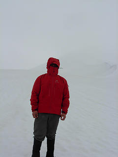 the forecast is never wrong 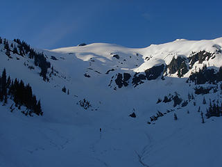 Ruth from head of Ruth Creek 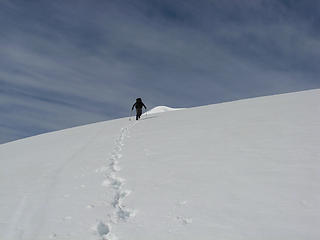 Tom nearing the summit 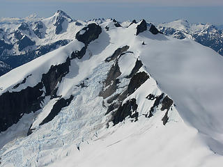 Icy from Ruth
"There can be no greater issue than that of conservation in this country."
Teddy Roosevelt August 6, 1912
"There can be no greater issue than that of conservation in this country."
Teddy Roosevelt August 6, 1912
|
| Back to top |
|
|
D. Inscho
Not bored yet...

Joined: 28 Feb 2010
Posts: 973 | TRs | Pics
Location: Bellingham,WA |
|
D. Inscho
Not bored yet...
|
Fri Jun 24, 2011 10:02 am |
|
|
Decisions, decisions, weather and gear. I'm glad it worked out, fabulously from the look of those pictures! Thanks for the ride!
http://david-inscho.smugmug.com/
The key to a successful trip is to do the planning during work hours. -- John Muir
My most memorable hikes can be classified as 'Shortcuts that Backfired'. --Ed Abbey
http://david-inscho.smugmug.com/
The key to a successful trip is to do the planning during work hours. -- John Muir
My most memorable hikes can be classified as 'Shortcuts that Backfired'. --Ed Abbey
|
| Back to top |
|
|
|
|


 Ruth in 2008


