| Previous :: Next Topic |
| Author |
Message |
ragman and rodman
Member


Joined: 28 Apr 2005
Posts: 1219 | TRs | Pics
Location: http://rgervin.com/ |
rodman and I drove over to Leavenworth
turned onto the Icicle Creek road and drove ~8.5 miles... then turned left onto FS7601 and drove ~3 miles to the Eightmile Lake trailhead (3320').
Mosquitoes chased us up the trail
over the log crossing of Pioneer Creek
past Little Eightmile Lake
and finally disappeared as we reached Eightmile Lake (4641) after hiking 3.3 miles from the trailhead.
We continued around the north side of the lake on a very good fishermans path
passed through a recent burn (it wasnt there in May of 2009) near the west end of the lake
made a final creek crossing at the end of the lake before heading cross-country
staying close to Eightmile Creek for a half-mile before reaching a huge avalanche swatch (4800) after hiking for a total of ~4.5 miles.
We continued to the west end of the avalanche swatch
turned NW and headed uphill in tall timber that was loaded with down trees
however, this was a better idea than dealing with nasty slide alder that filled the swatch. Occasionally we found some rock outcroppings that provided some relief from the down trees and slide alder, but the going was slow until we found continuous snow around 5800 feet
where we let the terrain funnel us into a small basin at 6400 feet.
From the basin we headed north
up the easiest looking gully
passed a waterfall on our left
and after gaining 600 feet of elevation we trended NW
reaching Eightmiles SW ridge (7600) near the low point between Point 7793 and the summit.
Thinking the days work was pretty much done proved to be wishful thinking. It took us 40 minutes to gain the next 200 feet of elevation on Class 3 rock before the terrain finally eased for the last 200 feet of elevation to the summit (7996). In hindsight we should have stayed on snow until reaching 7800 feet, avoiding the Class 3 rock entirely
and thats what we did on our return.
Views from this summit are both amazing and broad
with the in-your-face Stuart Range dominating.
From the summit we used our ice axe and plunge-stepped back down to the 6400 foot basin in 35 minutes
where the decision was made to take a more direct route down to the avalanche swatch
choosing to stay in snow until ~5700 feet and then bashing our way through 700 feet of slide alder
where we were finally able to exhale, knowing that we would live to see another day
and while the slide alder was a very unpleasant experience, at least it was pointed downhill.
The 4.5 mile hike from the swatch back to the car was uneventful as we barely avoided the need for using our head lamps.
13.5 miles roundtrip
gaining 4850 feet of elevation.
rodman and I stand in awe of the nwhikers who have reported doing this trip in the 9 to 10 hour range
and at the next gathering of the Eightmile Club the first round of drinks are on us. To put this in perspective, while you were back at your car having refreshments, we were pumping water at 5700 feet
getting ready to enter slide alder hell and facing a 4 hour hike back to our car.
While we dont like to use the word never when it involves hiking, rodman and I are in agreement that we will never visit this summit again
and having done Hi-Jack Peak in 2009, I dont have any plans of ever going beyond Eightmile Lake again.
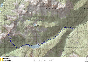
GPS route and photos of our trip to Eightmile Mountain.
..
|
| Back to top |
  
|
|
dave allyn
Member

Joined: 05 Apr 2011
Posts: 428 | TRs | Pics
|
I believe the route you guys are taking makes a lot more sense with more snow cover. I hiked eightmile last year via Little Caroline Lake and found it much more pleasant than the descent via approximately the route you took.
|
| Back to top |
|
|
Mike Collins
Member
Joined: 18 Dec 2001
Posts: 3097 | TRs | Pics
|
| ragman and rodman wrote: | | rodman and I stand in awe of the nwhikers who have reported doing this trip in the 9 to 10 hour range
and at the next gathering of the Eightmile Club the first round of drinks are on us. |
Tom Sjolseth, Justus, and I made a round-trip time of 7 hrs 15 min. I drafted behind them on the trail portion which made the going up a little easier.
|
| Back to top |
|
|
BarbE
Member

Joined: 28 Jul 2006
Posts: 1153 | TRs | Pics
|
|
BarbE
Member
|
 Fri Jun 24, 2011 3:02 pm |
|
|
|
| Back to top |
|
|
wildernessed
viewbagger

Joined: 31 Oct 2004
Posts: 9275 | TRs | Pics
Location: Wenatchee |
 Good times, I loved Eightmile Mtn, we hit it just right, a clear trail, and snow where we needed it, though the full sun was intense on the snow in the basin. I remember asking Steve about the route and he said, "We just walked right up after the lake", looking at the slide alder I said, "Steve, when did you do this trip ?, He said, "The late 60's"" Good times, I loved Eightmile Mtn, we hit it just right, a clear trail, and snow where we needed it, though the full sun was intense on the snow in the basin. I remember asking Steve about the route and he said, "We just walked right up after the lake", looking at the slide alder I said, "Steve, when did you do this trip ?, He said, "The late 60's""   . Here was our not to bad of a route. . Here was our not to bad of a route.
 Eightmile Route 08
Living in the Anthropocene
Living in the Anthropocene
|
| Back to top |
|
|
wildernessed
viewbagger
Joined: 31 Oct 2004
Posts: 9275 | TRs | Pics
Location: Wenatchee |
Ha !, your map is too funny. We had a lot more snow than you guys. The views are great. I do remember Beave laying on the snow face down trying to cool off once on the way up the basin.
Living in the Anthropocene
Living in the Anthropocene
|
| Back to top |
|
|
Magellan
Brutally Handsome

Joined: 26 Jul 2006
Posts: 13116 | TRs | Pics
Location: Inexorable descent |
|
Magellan
Brutally Handsome
|
Fri Jun 24, 2011 4:17 pm |
|
|
Did you find an ice axe in the alder? Nice trip.
|
| Back to top |
|
|
tigermn
Member

Joined: 10 Jul 2007
Posts: 9242 | TRs | Pics
Location: There... |
|
tigermn
Member
|
Fri Jun 24, 2011 9:41 pm |
|
|
| ragman and rodman wrote: | | While we dont like to use the word never when it involves hiking, rodman and I are in agreement that we will never visit this summit again
|
Nice report. The above seems to be a common sentiment of those that venture there 
|
| Back to top |
|
|
ragman and rodman
Member
Joined: 28 Apr 2005
Posts: 1219 | TRs | Pics
Location: http://rgervin.com/ |
| dave allyn wrote: | | I believe the route you guys are taking makes a lot more sense with more snow cover. I hiked eightmile last year via Little Caroline Lake and found it much more pleasant than the descent via approximately the route you took. |
I think you are probably correct about the snow cover. We had been talking about our route since the end of May, but the stars just didn't align until a few days ago. Considering the heavy snowfall this year I thought we might still be okay. We had read several reports from past years and everyone seemed to be going up from Eightmile Creek... so we just took our place in line and followed the herd up.
--------------------------------------------------------------------------------
| Mike Collins wrote: | | Tom Sjolseth, Justus, and I made a round-trip time of 7 hrs 15 min. I drafted behind them on the trail portion which made the going up a little easier. |
Whoa!... we were still 45 minutes from reaching the summit when you got back to your car... thanks for confirming where we fit in the food chain... and two rounds of drinks for you guys at the next club meeting.
--------------------------------------------------------------------------------
| wildernessed wrote: | | Ha !, your map is too funny. We had a lot more snow than you guys. The views are great. I do remember Beave laying on the snow face down trying to cool off once on the way up the basin. |
We appreciated your GPS plot very much and definitely benefited from it... and wish we had paid more attention to how you guys stayed on snow until you got to 7800 feet... staying on or very near the SW ridge from 7600 to 7800 feet cost us 30 minutes that could have been better utilized relaxing on the summit.
--------------------------------------------------------------------------------
| Magellan wrote: | | Did you find an ice axe in the alder? |
Sorry, but we didn't find your axe... I almost left one of my trekking poles there... bet there is a lot of gear in that patch of slide alder... probably a person or two also.
..
|
| Back to top |
|
|
Snowdog
Member

Joined: 21 Jul 2006
Posts: 1028 | TRs | Pics
Location: on (& off) the beaten path |
|
Snowdog
Member
|
Sun Jun 26, 2011 9:42 am |
|
|
| ragman and rodman wrote: | | and while the slide alder was a very unpleasant experience, at least it was pointed downhill. |
my sentiments exactly! go with the grain....
'we don't have time for a shortcut'
'we don't have time for a shortcut'
|
| Back to top |
|
|
|
|


