Forum Index > Trip Reports > Devore Creek + Sable Ridge 7/16-22/2011
 Reply to topic
Previous :: Next Topic
Author Message
Stefan
Member
Member


Joined: 17 Dec 2001
Posts: 5093 | TRs | Pics
Stefan
Member
PostThu Jul 28, 2011 9:19 am 
The original plan was to do a traverse in the Picketts with two other people. However, that fell through due to the weather forecast not having any high pressure. I am sure glad we changed plans from the weather we encountered being in a “drier” area. And every night Greg had fire going. Day 1 Car. Boat to Stehekin. Met a great group of guys doing Agnes and Sinister and Gunsight. Take the new fangled buses. Okay, I have to complain. The regular bus worked fine. Now they have these new fangdangled red tourist buses at Stehekin. Do you know how much $$$$$! If the old system worked, why replace it? Walk in the rain to the end of the airport. Boots were wet within 30 minutes and stayed wet for 7 days. Hike to Bird Camp. Fire! Day 2. Devore/Wy’North/White Goat. We left Bird Camp around 7:00ish. Walked up the right side of Bird Creek and crossed around 5200 feet in some minor brush and kept traversing to the basin….basically following the excellent route description by Paul Klenke on summitpost.org. Weather was cooperating and we did sweat, but not the full on heat! Devore Peak. We easily went up the ramp to the upper lakes and on the ridgeline over to 4th class section of the route. Yes, it is fourth class for one move. And then it became a little more complicated to the summit. We took the rope further and did use it for a handline coming down a class 3 section over to the summit, but not used in the same return section. The register is cool!
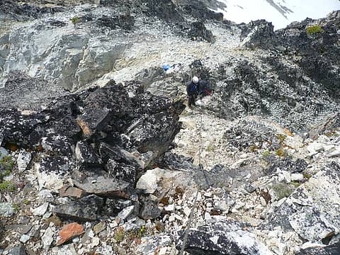
4th class on devore
4th class on devore
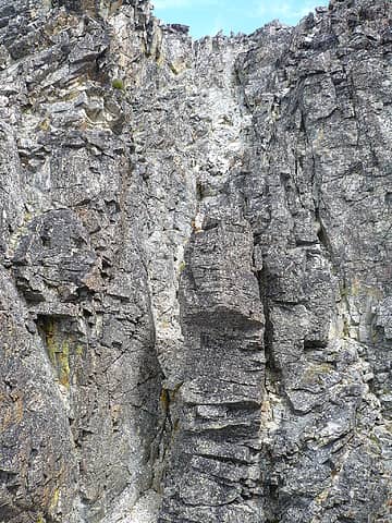
last gully on Devore
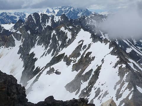
looking at wynorth
looking at wynorth
Wy’ North. We came back down to around 7400 feet on the southeast side of Devore and then laid our packs next to some tree. We then traversed south and then went up a steep snow filled coulouir on the east side of Wy’North and some more scrambling ending south of the peak and then on up to the peak. Register there was placed by Don G., and signed by Fay P., but we did not have a pencil to contribute. Back down we went. Don G., said it took him 2.5 hours round trip to the summit of Wy’North to the Bird Creek lakes…..well, it took us the same time, from our 7400 feet point southeast of Devore—that meant Donnie G was smoking fast because he covered our same distance plus about 1.5 miles more and 400 feet!
White Goat. We easily scrambled over to the east ridgeline base for this peak. Now I will have to say, at first it does look intimidating compared to the description of the route I had. All I had for description was low class 5. Well, once you start on the rock, it really is low class 5. The holds are there and good. Some rotten stuff, and you do need to be carefull. A full 150 feet pitch gets you to the top boulder with slings and some caribeners. The remaining ridgeline scramble to the summit is exposed an a bit weak. The summit register is a tube with cork on both ends. We could NOT get it open. So we did not sign. It did take 2 rappels down. For some reason we could not find where people were rappelling on the second place. Hmmmm. Anyway we came down and then went to the basin downclimbing loose scree to around 7000 feet on our way over to Tupshin. We knew we could not do Tupshin on this day, we only wanted to drop our climbing gear around 6000 feet for the return on the next day….and so we did. Back to Bird Creek camp at 9:00p.m. for a 14 hour day. Fire!
Day 3. Tupshin. We once again followed Paul Klenke’s excellent route description on summitpost.org. That’s really what we did. The only thing that surprised me was the 4 single rope rappels we did. I guess I wasn’t mentally prepared for that. Weather was pretty darned good for the entire day. The climbing was there as Paul describes. The only thing I would add to his route description is on pitch 3. We took his ledge route leading out to the right to the East Ridge proper. The route does go near a living bush, then higher to a dead bush, but I would still extend the climb another 30 feet to a visible tree—which is a good belay point just up and to the left of the dead bush. To get to this tree requires a low class 5 move on solid rock. Two more pitches/sections and on to the top. The summit has the original register dry, but unreadable due to historical damage in the can. I was tempted to take it and give it the UW library; however, I knew I was going to be in area for several more days, and if I accidently destroyed that piece of paper, I would feel depressed—so I left it back in the can. 4 rappels. Oi. 9.5 hours round trip back to Bird Camp. Fire!
Day 4. Wy’East and Johnsons Jonah. Weather forecast before we left had this day as the worst. It was, but not by wetside standards. We took the trail up Devore Creek and wouldn’t you know it, we had snowpatches at 4600 feet! Starting in the third week of July! I also so my very first porcupine off the trail in the wild—I wonder how the Indians ate them? We left the mostly covered Devore Creek snowtrail up to 4th of July basin and dropped our stuff. We looked up and said, yep, that’s our peak. I had absolutely no information for Wy’East. None. So we went up. And guess what? We were on the wrong peak. We were way too far to the southeast. So we traversed all the little pinnacle going northwest. We did come to one large pinnacle unpassable before the summit so we downclimbed a gully and then went around it. We actually ended up on one pinnacle just east of the summit. And we did have to rappel down it to go up a gully on the east side of the summit. So when you are at the summit of Wy’East and you look east, and you see a rappel sling on the next pinnacle over…that is ours! This gully up to the summit does not require rope to the summit and is not the standard route to the summit (it is one gully to the east of the standard route). It is a tighter gully and probably why people don’t take it to the summit. The summit was not enjoyed for more than 5 minutes. Rain showers, wind, and so we went down. We went down to the 4th of July basin and sat in our tent for 2 hours while we took a nap during some of the rain showers. Eventually the weather created “many sucker holes” and so we left our confines carrying full packs up to the Johnson’s Jonah/Black Tower col. The wind had picked up by the time we were at the col but still not precipitating too much and we scrambled up to the top of Johnson’s Jonah signing in the Fay register. Our original intention was to camp at Hilgard Pass, so we would have a good start on Sable Ridge for the next day but with about 3 feet of snow there, we opted to go camp low, and we found a place in the forest about 400 yards after the meadow below around 5500 feet next to a large tree and totally flat space for the tent. Fire!
Day 5. Sable Ridge. Up to Hilgard Pass and enjoying the glacial lilies on the way up. Mostly snow on the trail starting around 6000 feet. I have never been over this pass, and I will say the most treacherous part of this day was coming down Hilgard Pass where the snow probably covered 50% of the trail. It was steep and somewhat hard for snow. We eventually made it down and over to the lovely Hilgard basin. From here it was an easy stroll on rock, snow, scree over to the summit of Sable Ridge south where Fay and Mike had been about 3 weeks previous to our trip. Weather was still cloudy this day, but with mostly sun. I was a little worried about coming off of this peak because Fay and Mike and mentioned about a treacherous gully downclimb. Well, I don’t know why they did it, because coming off of Sable Ridge south on the traverse over to Sable Ridge north is class 2 if you go to the 7200’ closed contour to the west. We saw their way down and it did not look pleasant. In fact our way was easier coming down off of Sable Ridge south than off of Hilgard Pass! From here it was easy traversing up and over 2 or 3 cols and then up to the summit of Sable Ridge north. From here we were treated with a sight no one has ever seen before—a summit register donated by Mitch B. What a treat! A very nice one too. Greg and I were the third party to ever ascend this peak….followed by Mitch B., and Mike C., and then by Fay and Mike a couple weeks prior. Nice place this peak is at. We then came down the right hand side of an avalanche path below the basin that is to the southeast of Sable Ridge north. You might think this is terrible brush…well, there was brush, but not terrible, it appears the animals have made a path in there and you can see it—once you are on the path. Just stay in this path between the forest and the avalanche path. We made it down to the valley bottom of Hilgard Creek. Well, we missed the trail and we were too far to the south. I opted a very very small tree to cross the creek, while Greg went on to find a larger log to cross. Back up to Hilgard Pass….easier to go up than down…and then we attempted Black Tower. For some reason we got off route because we became confused up there. We eventually figured it out, but we were running out of daylight if things went haywire and decided to come back the next day. Fire!
Day 6. Black Tower. Rain in the morning. Do we go up? Let’s wait it out. Well, we slept in until 11:00a.m. and eventually started from camp at 12:30 for Black Tower. This time we had the route dialed in. We went to around 6400’ on the trail and traversed directly east into the main gully between the true summit and the false summit which was filled in with snow, went up this gully for about 300 feet, then took a left and westerly on some more snow almost to the west ridgeline. Just before the ridgeline follow more class 2ish rock up and to the east and to a 10 foot tree that is half dead and alive. Go easterly over a ridgeline and into another gully. This gully might go to the top. We continued on. We went around a second ridgeline into the second gully and then up. This second gully has a small stiff class 3 section with smooth rock. Go up. It goes back to class 2, then one class 3 move into a very wide class 2 /class 3 gully. At the top you can go straight up a fin to the summit or you can go left around and up. Climbers left and around to the top is less exposed, but not as sporty. We enjoyed the summit for less than 10 minutes. A snow squall and wind dominated the summit while we were there for a short time. 2.5 hours to the top. We did do a single rappel down the wetish rock from the route we came up. 2 hours back to camp. It was weird. After several long days for climbing, this day felt like we never left camp. Fire!
Day 7. Out to Holden. Bus. Boat. Car.

Art is an adventure.
Back to top Reply to topic Reply with quote Send private message
dicey
custom title


Joined: 11 May 2004
Posts: 2870 | TRs | Pics
Location: giving cornices a wider berth
dicey
custom title
PostThu Jul 28, 2011 11:11 am 
Nice plan B Stefan. How was the trail to Bird camp- brushed out yet?

I'm not always sure I like being older but being less stupid has advantages. http://www.flickr.com/photos/32121172@N00/sets/
Back to top Reply to topic Reply with quote Send private message
Stefan
Member
Member


Joined: 17 Dec 2001
Posts: 5093 | TRs | Pics
Stefan
Member
PostThu Jul 28, 2011 12:21 pm 
dicey wrote:
Nice plan B Stefan. How was the trail to Bird camp- brushed out yet?
I think there was only one downed log on the way to Bird Camp. That was the first time I was up the trail from Stehekin. Has lots of brush at knee heighth after the trail comes closer to the creek in the canyon...but then ends before you get to Bird Camp like a mile or so.

Art is an adventure.
Back to top Reply to topic Reply with quote Send private message
Redwic
Unlisted Free Agent


Joined: 23 Feb 2009
Posts: 3292 | TRs | Pics
Location: Going to the Prom(inence)
Redwic
Unlisted Free Agent
PostThu Jul 28, 2011 12:26 pm 
Nice work!!!

60 pounds lighter but not 60 points brighter.
Back to top Reply to topic Reply with quote Send private message
Roald
Member
Member


Joined: 06 Aug 2007
Posts: 367 | TRs | Pics
Location: Seattle
Roald
Member
PostThu Jul 28, 2011 12:55 pm 
Man, you prowled all over that area! I like the TR. Fire! lol.gif

Back to top Reply to topic Reply with quote Send private message
Randy
Cube Rat


Joined: 18 Dec 2001
Posts: 2910 | TRs | Pics
Location: Near the Siamangs
Randy
Cube Rat
PostThu Jul 28, 2011 3:12 pm 
This report is timely. Thanks!

Back to top Reply to topic Reply with quote Send private message
cartman
Member
Member


Joined: 20 Feb 2007
Posts: 2800 | TRs | Pics
Location: Fremont
cartman
Member
PostThu Jul 28, 2011 3:49 pm 
What dates were you in there, Stefan? Grant M. and I were in there 7/23-25 doing Flora and Castle via Tenmile Pass, we were in Holden the 25th and 26th am.

Back to top Reply to topic Reply with quote Send private message
Stefan
Member
Member


Joined: 17 Dec 2001
Posts: 5093 | TRs | Pics
Stefan
Member
PostFri Jul 29, 2011 8:49 am 
cartman wrote:
What dates were you in there, Stefan? Grant M. and I were in there 7/23-25 doing Flora and Castle via Tenmile Pass, we were in Holden the 25th and 26th am.
We were in there 7/16-22/2011.

Art is an adventure.
Back to top Reply to topic Reply with quote Send private message
Magellan
Brutally Handsome


Joined: 26 Jul 2006
Posts: 13116 | TRs | Pics
Location: Inexorable descent
Magellan
Brutally Handsome
PostFri Jul 29, 2011 9:00 am 
Awesome! No whiners here. up.gif up.gif Fire!

Back to top Reply to topic Reply with quote Send private message
DIYSteve
seeking hygge


Joined: 06 Mar 2007
Posts: 12655 | TRs | Pics
Location: here now
DIYSteve
seeking hygge
PostFri Jul 29, 2011 10:25 am 
action packed up.gif

Back to top Reply to topic Reply with quote Send private message
cascadetraverser
Member
Member


Joined: 16 Sep 2007
Posts: 1407 | TRs | Pics
cascadetraverser
Member
PostMon Aug 01, 2011 5:04 pm 
Nice trip; never been to that neck of the cascades; any traverse potential out there?

Back to top Reply to topic Reply with quote Send private message
medic711
Member
Member


Joined: 18 Jan 2013
Posts: 3 | TRs | Pics
medic711
Member
PostFri Jan 18, 2013 7:39 pm 
hmm, this might be yours
074
074

Back to top Reply to topic Reply with quote Send private message
Backpacker Joe
Blind Hiker


Joined: 16 Dec 2001
Posts: 23956 | TRs | Pics
Location: Cle Elum
Backpacker Joe
Blind Hiker
PostSat Jan 19, 2013 12:51 pm 
Sadly, too early to see the bird lakes.

"If destruction be our lot we must ourselves be its author and finisher. As a nation of freemen we must live through all time or die by suicide." — Abraham Lincoln
Back to top Reply to topic Reply with quote Send private message
   All times are GMT - 8 Hours
 Reply to topic
Forum Index > Trip Reports > Devore Creek + Sable Ridge 7/16-22/2011
  Happy Birthday Lead Dog, dzane, The Lead Dog, Krummholz!
Jump to:   
Search this topic:

You cannot post new topics in this forum
You cannot reply to topics in this forum
You cannot edit your posts in this forum
You cannot delete your posts in this forum
You cannot vote in polls in this forum