| Previous :: Next Topic |
| Author |
Message |
FungiFan
Member

Joined: 09 Sep 2010
Posts: 395 | TRs | Pics
Location: East of the Olympics |
|
FungiFan
Member
|
 Wed Aug 03, 2011 10:29 am |
|
|
Inspired by recent reports of people actually making it to the alpine country of ONP/ONF before summer comes to a close we decided to hike the Big Quilcene trail to Marmot Pass. We left early Tuesday am and found the Trail head was moderately busy for a week day, probably from pent up demand. The forecast was for mostly sunny, we had mostly cloudy with occasional sunny spells on the way up. Given this hike starts climbing from the get go that was probably a good thing!
Big Quilcene river from the trail
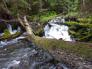 Log Jam on the BIg Quilcene River 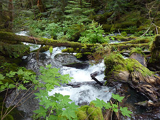 Big Quilcene River 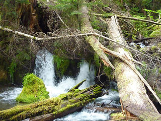 Log Jam on the Big Quilcene 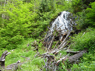 Trailside waterfall 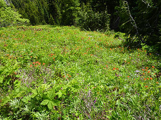 Meadow 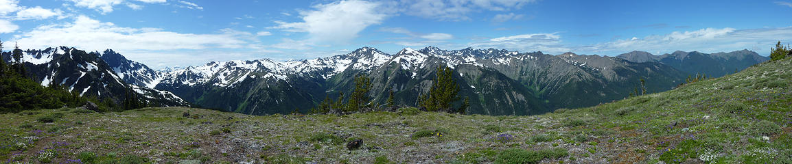 View from above Marmot Pass 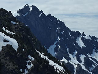 Inner Constance 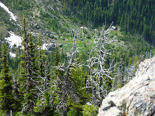 Boulder Shelter from the ridge 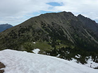 Mt Buckhorn 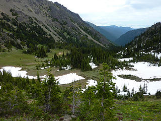 Meadow below Marmot Pass
Stupid isn't illegal...but sure comes with consequences.
Famous last words: 'Here, hold my beer and watch this.'
Stupid isn't illegal...but sure comes with consequences.
Famous last words: 'Here, hold my beer and watch this.'
|
| Back to top |
  
|
|
tigermn
Member

Joined: 10 Jul 2007
Posts: 9242 | TRs | Pics
Location: There... |
|
tigermn
Member
|
Wed Aug 03, 2011 11:45 am |
|
|
| FungiFan wrote: | | For anyone planning a trip to Marmot Pass I would highly recommend going the extra ~ 1 mile along that south ridge. It opens up the view of the Dungeness Valley both north and south and is worth the extra climb. |
Nice report. I kinda wondered what it might have been like coming up the other side (I came up Tubal Cain trail on Monday).
Heading north from the pass ain't half bad either plus then the option to ramble up Buckhorn Peak for even more views.
Looked like some snow fields still to traverse but I didn't go far enough towards the pass from the north to see what the conditions were really like. If you are uncomfortable on traversing snow fields though it is something to think about. I know many on NW hikers take it as nothing but if you aren't one of those it is something to consider.
|
| Back to top |
|
|
FungiFan
Member
Joined: 09 Sep 2010
Posts: 395 | TRs | Pics
Location: East of the Olympics |
|
FungiFan
Member
|
Wed Aug 03, 2011 2:51 pm |
|
|
I was surprised at how little snow there was on the Big Quilcene trail. Since the spring we had been climbing ever higher from the Dungeness trail assuming it would likely melt out sooner given the exposure. We too had considered the Tubal Cain approach and might have done it if we had seen your TR before leaving, I choose the BQ trail as several at WTA reported no issues last weekend. You can see from our pictures that Buckhorn is snow free on the S exposure. There was no snow on the portion of the Tubal Cain trail seen from Marmot Pass, nor on the trail ascending Buckhorn.
Our one attempt to climb Buckhorn turned into a white out so it remains on the to do list. Given the late snow melt and my need to study for an upcoming recertification exam it will likely wait until next season. My priorities this year will be a return to Upper Royal basin and to Charlia lakes.
FF
Stupid isn't illegal...but sure comes with consequences.
Famous last words: 'Here, hold my beer and watch this.'
Stupid isn't illegal...but sure comes with consequences.
Famous last words: 'Here, hold my beer and watch this.'
|
| Back to top |
|
|
jimmymac
Zip Lock Bagger

Joined: 14 Nov 2003
Posts: 3705 | TRs | Pics
Location: Lake Wittenmyer, WA |
|
jimmymac
Zip Lock Bagger
|
Wed Aug 03, 2011 3:11 pm |
|
|
Did you get a glimpse of the snow conditions down on the Charlia Gap boot path above Boulder Shelter?
"Profound serenity is the product of unfaltering Trust and heightened vulnerability."
"Profound serenity is the product of unfaltering Trust and heightened vulnerability."
|
| Back to top |
|
|
FungiFan
Member
Joined: 09 Sep 2010
Posts: 395 | TRs | Pics
Location: East of the Olympics |
|
FungiFan
Member
|
Wed Aug 03, 2011 5:35 pm |
|
|
No, unfortunately not. That was what I was hoping to assess when we took the ridge path. There are patches of snow around Boulder Shelter as you can see. What I couldn't see was just around the ridge S of Boulder Shelter where the trail continues S and then the final eastward, steep ascent to the pass into Charlia Lakes  . If the last section has snow it would be a no go for us. Realistically I think my next trip won't be until the end of the month so it should be snow free by then.
FF . If the last section has snow it would be a no go for us. Realistically I think my next trip won't be until the end of the month so it should be snow free by then.
FF
Stupid isn't illegal...but sure comes with consequences.
Famous last words: 'Here, hold my beer and watch this.'
Stupid isn't illegal...but sure comes with consequences.
Famous last words: 'Here, hold my beer and watch this.'
|
| Back to top |
|
|
half fast
member

Joined: 21 Mar 2010
Posts: 1392 | TRs | Pics
Location: Living the dream in my 5th Wheel |
It's all about the fun, oh and maybe the chocolate - half fast
|
| Back to top |
|
|
Matt Lemke
High on the Outdoors

Joined: 15 Jul 2010
Posts: 2052 | TRs | Pics
Location: Grand Junction |
|
Matt Lemke
High on the Outdoors
|
Wed Aug 03, 2011 11:18 pm |
|
|
Went up that same ridge when I was last there. Saw a fantastic sunrise from there and the views are much better than at the pass!
|
| Back to top |
|
|
FungiFan
Member
Joined: 09 Sep 2010
Posts: 395 | TRs | Pics
Location: East of the Olympics |
|
FungiFan
Member
|
Thu Aug 04, 2011 8:43 pm |
|
|
Tuesday, Aug 2nd. I just read your report, great pictures as always.
FF
Stupid isn't illegal...but sure comes with consequences.
Famous last words: 'Here, hold my beer and watch this.'
Stupid isn't illegal...but sure comes with consequences.
Famous last words: 'Here, hold my beer and watch this.'
|
| Back to top |
|
|
Phil
Member

Joined: 02 Jul 2003
Posts: 2025 | TRs | Pics
Location: Shoreline, WA |
|
Phil
Member
|
Fri Aug 05, 2011 6:05 am |
|
|
| FungiFan wrote: | Meadow below Marmot Pass |
Love this one!
|
| Back to top |
|
|
Ancient Ambler
Member

Joined: 15 May 2007
Posts: 1092 | TRs | Pics
Location: Bainbridge Island |
Very nice trip and report, as always, FF. It is surprsing how much the view improves if you are willing to run the ridge either south from Marmot Pass, or north and up the Buckhorn way trail, even a fairly short distance. Really enjoyed your shots of Inner Constance and Constance Pass--amazing how much snow is still on the north-facing section of Constance Pass this late in the summer.
|
| Back to top |
|
|
|
|


 Thanks for sharing...