| Previous :: Next Topic |
| Author |
Message |
Sadie's Driver
Sadie's Driver


Joined: 24 Apr 2006
Posts: 1763 | TRs | Pics
Location: Welcome Pass |
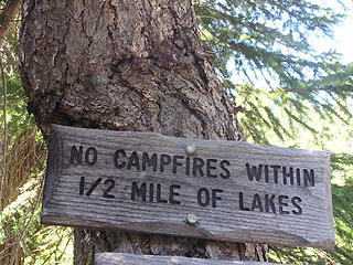
OK - for a number of reasons, the overnight to Chain Lakes and Bulls Tooth (to deposit the NW Hikers Traveling Register) turned into a day trip. The original Gang of 9, turned into a modest two (Driver and Middle E - Barry) along with Gus the lead dog. A day trip was a good decision and a bad decision. In any case, the Driver had done this trip four years ago with Trail Pair Bulls Tooth 2007. We decided to cut off about 3 1/2 miles by going up the Mill Creek Road (at the Stevens Pass Nordic Center turn). I don't think my Highlander has forgiven me! WARNING: Do not try this with Mom's Taurus! Likely my next repair bill will be a new suspension system! If you go this route, be aware that about 2 miles in you will come to a "Y" - take the left hand road. From there, the road turns from lousy to awful! We did a little minor road reconstruction at a small creek crossing in order to ensure that I wouldn't bottom out. It worked. From there you continue on to a hairpin turn (where you can pull over and park) or you can continue a little farther up the road to another turn-around and parking area - which is what we did, because there already was someone parked at the hairpin. NOTE: there is a "Caution" tape hung here by the creek and what looks to be the start of the trail.
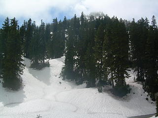
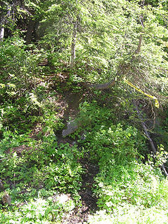 Not here! 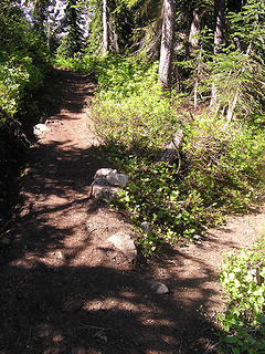 Fork to the right is the short cut down to Mill Creek Road (this is the view heading north on the PCT) 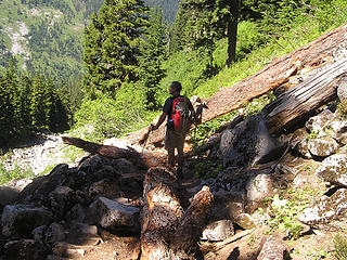 Blow down on the PCT 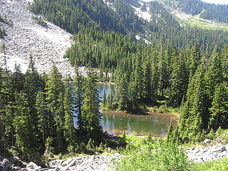 Lake Susan Jane 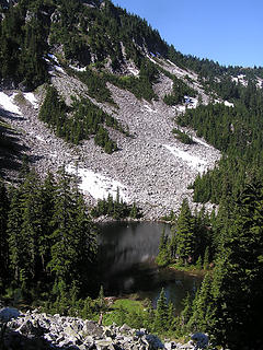 Susan Jane 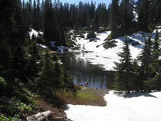 Pondlet above Susan Jane is still partially frozen - Gus doesn't care! 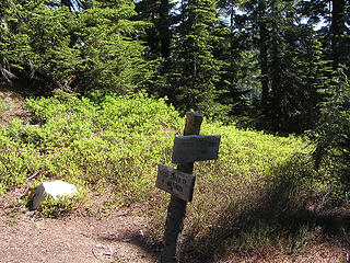 Several forks in the road 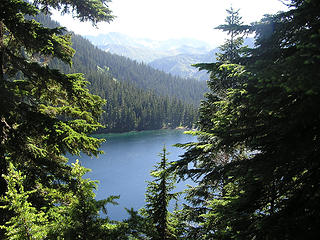 Lake Josephine from the north 
 Probably couldn't read this!  The blow downs are incredible! This pretty much shows our adventure! The blow downs are incredible! This pretty much shows our adventure!
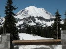
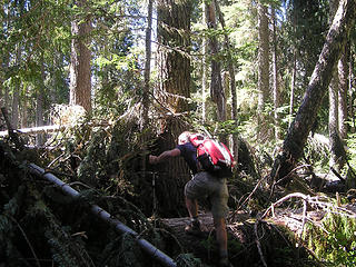 Over 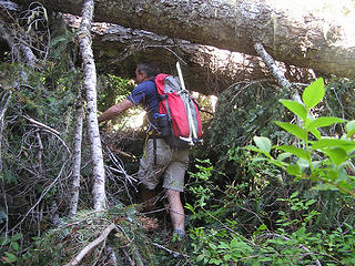 Under 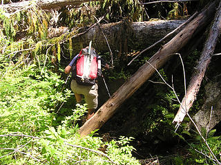 More under 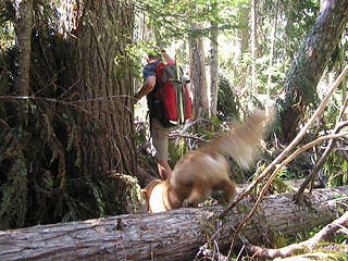 Around 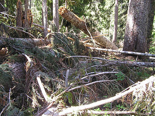 A big mess! 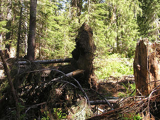 Knocked down roots and all 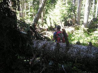 Now what? 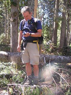 Where the heck is the junction? 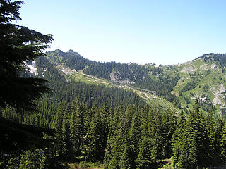 Ski area - Stevens Pass  
Four-paw buddy lets me tag along!
Four-paw buddy lets me tag along!
|
| Back to top |
  
|
|
Backpacker Joe
Blind Hiker

Joined: 16 Dec 2001
Posts: 23956 | TRs | Pics
Location: Cle Elum |
Nice work guys. Dang, and I had hopped to get into the Chains that way. Ugh. Its gonna suck.
"If destruction be our lot we must ourselves be its author and finisher. As a nation of freemen we must live through all time or die by suicide."
Abraham Lincoln
"If destruction be our lot we must ourselves be its author and finisher. As a nation of freemen we must live through all time or die by suicide."
Abraham Lincoln
|
| Back to top |
|
|
Sore Feet
Member

Joined: 16 Dec 2001
Posts: 6307 | TRs | Pics
Location: Out There, Somewhere |
Wow, that's ugly. Between Whitepine and the Chain Lakes Trail was fairly brushy and had a few blowdowns in September of '09, but nothing anywhere near that bad.
|
| Back to top |
|
|
Matt
Tea, Earl Grey, Hot

Joined: 30 Jan 2007
Posts: 4307 | TRs | Pics
Location: Shoreline |
|
Matt
Tea, Earl Grey, Hot
|
 Sat Aug 13, 2011 11:54 pm |
|
|
Yuck. That's too bad about the blowdowns.
As beacons mountains burned at evening. J.R.R. Tolkien
As beacons mountains burned at evening. J.R.R. Tolkien
|
| Back to top |
|
|
Trailblazing Todd
Trail Wanderer

Joined: 26 Mar 2010
Posts: 126 | TRs | Pics
Location: Everett |
The tree obstacle course is fun practice, is it not!   What a difference 3 weeks makes. What a difference 3 weeks makes.
 Pondlet area 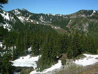 View from Susan Jane (after)
Wherever the trail takes me.
Wherever the trail takes me.
|
| Back to top |
|
|
Sadie's Driver
Sadie's Driver
Joined: 24 Apr 2006
Posts: 1763 | TRs | Pics
Location: Welcome Pass |
Four-paw buddy lets me tag along!
|
| Back to top |
|
|
DRSpalding
Probably riding MTB
Joined: 13 Mar 2008
Posts: 458 | TRs | Pics
Location: Redmond, WA |
|
DRSpalding
Probably riding MTB
|
Sun Aug 14, 2011 9:55 am |
|
|
Sigh, it sounds like I'll have to postpone my bike-hike-bike ramble of stashing a bike at Black Pine on Icicle Creek, day-hiking from Stevens Pass to the bike and riding back to Leavenworth for a Gustav burger and beer or a South mole enchilada and margarita before heading back over Stevens Pass. I want the hiking part of roughly 16 miles or so to be more of a cruise than a crusade against the blowdowns.
Has anyone gone on the PCT from Stevens Pass to Lake Susan Jane? I am trying to schedule the 2/3 of a mini triathlon sometime during the last week of August.
|
| Back to top |
|
|
Snowdog
Member

Joined: 21 Jul 2006
Posts: 1028 | TRs | Pics
Location: on (& off) the beaten path |
|
Snowdog
Member
|
Sun Aug 14, 2011 11:09 am |
|
|
boy am I ever glad we opted out! An obstacle course is not what the doctor ordered at the moment. 
'we don't have time for a shortcut'
'we don't have time for a shortcut'
|
| Back to top |
|
|
Type E
Member

Joined: 19 Aug 2006
Posts: 1381 | TRs | Pics
|
|
Type E
Member
|
Sun Aug 14, 2011 12:15 pm |
|
|
Glad you were able to find the secret shortcut trail, it makes Chain Lakes much more manageable as a day hike. At least the weather cooperated with you, I haven't had that luck in the few times I have been to Chain Lakes. I plan on being there in two weeks and thankfully I won't be using your approach.
Eric
|
| Back to top |
|
|
Backpacker Joe
Blind Hiker
Joined: 16 Dec 2001
Posts: 23956 | TRs | Pics
Location: Cle Elum |
I know a guy who did that trip but to lower Doelle and back in a day hike the next day after you guys were there. He's an animal.
"If destruction be our lot we must ourselves be its author and finisher. As a nation of freemen we must live through all time or die by suicide."
Abraham Lincoln
"If destruction be our lot we must ourselves be its author and finisher. As a nation of freemen we must live through all time or die by suicide."
Abraham Lincoln
|
| Back to top |
|
|
the Zachster
Member

Joined: 17 Jan 2007
Posts: 4776 | TRs | Pics
Location: dog training |
So there have been 3 mantras for this summer...
#1: "I can't believe how much snow there is here"
#2: "At least it's not raining"
and #3: "I can't believe how many trees are down here"
What a summer! Glad you enjoyed your time outside!
"May I always be the kind of person my dog thinks I am"
"May I always be the kind of person my dog thinks I am"
|
| Back to top |
|
|
Middle E
no more moustache

Joined: 10 Feb 2008
Posts: 432 | TRs | Pics
Location: Seattle, WA |
|
Middle E
no more moustache
|
Sun Aug 14, 2011 3:50 pm |
|
|
| Sadie's Driver wrote: | A big mess! Knocked down roots and all Now what? |
This was the worst blowdown I've ever seen. No, it was not impenetrable. If you had to, you could get through it. But having no idea whether relief was 50 yards away or 500 yards away we didn't really agonize over deciding to turn back and try again another day or another route.
pithy yet insightful signature
pithy yet insightful signature
|
| Back to top |
|
|
Billoutwest
Member
Joined: 01 Aug 2011
Posts: 260 | TRs | Pics
Location: Redmond Oregon |
Ouch.
Man that is impressive.
I"ll wonder out loud about how much is on that trail crews plate and even if that level of blowdown could be handled this year.
Cross cuts were known as misery whips.
|
| Back to top |
|
|
Billoutwest
Member
Joined: 01 Aug 2011
Posts: 260 | TRs | Pics
Location: Redmond Oregon |
Modern trail crews are usually handicapped by the ground they cover.
In the old days cross cut users had two basic types of saws to choose from.
Bucking, (thicker and wider) and falling saws (thinner and lighter).
Nowadays the trail crews use the falling saws for bucking because of pack weight. They're counting on usually just a couple bucks and take off hiking to the next one.
=============
Here is a 6 1/2 ft bucking saw that would be perfect for that mess.
 ==============
|
| Back to top |
|
|
Billoutwest
Member
Joined: 01 Aug 2011
Posts: 260 | TRs | Pics
Location: Redmond Oregon |
You're going to think I'm crazy.
Buy and pack a top quality hand saw.
These would be the type of non-motorized saw used by an arborist in a tree.
Weight is under one pound with case for a 10-12" blade.
===============
Think about being able to cut 20 limbs in a day to make the trail a little better and have a great firewood saw.
This will not make it with any ultralight campers ..........
Sorry, I'd like to recommend a product but doubt that is allowed on the forum.
|
| Back to top |
|
|
|
|


 Honestly, we tried everything - going further up-slope was just as awful. I supposed we could have waded in the creek!
  P.S. The bugs are in full bloom - fine when you're moving - but you become human suet stick once you stop!!! Double ugh.
