| Previous :: Next Topic |
| Author |
Message |
Stefan
Member


Joined: 17 Dec 2001
Posts: 5093 | TRs | Pics
|
|
Stefan
Member
|
 Tue Aug 23, 2011 2:48 pm |
|
|
The day before Greg and I did Chimney Rock (https://www.nwhikers.net/forums/viewtopic.php?t=7993499) and this day we went up Overcoat Peak.
The way up to the Overcoat Glacier was fairly straightforward again and basically straight up. You could enter the Overcoat Glacier tongue directly by the East Peak of Chimney Rock, but we ended up going to the closed contours at 6600+/6640+ slightly further to the northeast. We walked over to the 40 degree snow neve that Beckey describes in the route. We started up it. And decided to not do it because it became rather hard. I actually liked it because I am very comfortable on snow, but due to Gregs lack of stiffness in his boots he was skeptical of coming down this route. So we went around to the south ridge and decided to follow Randy and Beaves trip report: https://www.nwhikers.net/forums/viewtopic.php?t=6918&highlight=overcoat. In the report Beave talks about a ledge system that you mainly follow
.he was skeptical
but it went. How hard can this ledge system be after the ledges of Chimney Rock?
So, we took a look. Well, since we had been on Chimney Rock before and experienced great ledges, these Overcoat ledges are about a 1/3 of the size! What the? And to top it off, we saw three snow patches that would have hindered our progress. Oh well. BACK again we went to the snow neve and up the steep snow we went.
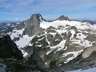
The snow neve never gets sun. It was hard, but my aluminum crampons could go in. Had to kick several times to get something in. The distance is probably about 300 feet from top to bottom. This took some time going up and the toes took some beating due to the types of boots we had. We then reached the top of the snow neve and Beckey says to go to the West or Southwest Face. Uh, there is a moat that probably goes down to sea level next to very steep wall. He is incorrect! What he meant to say was You go EAST. EAST. EAST across stiff class 3 slabs to the direct north ridge. From here you can drop slightly or go directly 100 feet (in distance but NOT in elevation) across whatever fits your fancy and then go up a gully that has heather benches at first which is easy class 3 to the summit--maybe the very last move is a very short class 4.
No register on the summit but an interesting piece of metal drilled on top. Views were again fantastic.
I took a look at the route down from Randy and Beaves trip report and I could see Randys short rope length of slings he had made..in 2004
.well that did not look too bad that way. So we decided to go that way back
maybe the ledge system was not so bad. Wrongo.
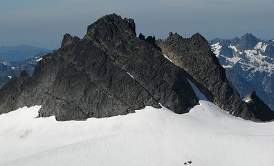
We first came down the East side of Overcoat, then swung down a gully on to the West side. Some class 3 to get down here. Then the rocks go to downsloping slab either class 4 or low class 5. I do NOT like downsloping slabs. NOT. We rappelled by Randys 7-8 sling connection. Can you see Randy's rope sling connect in this picture?:
Next up was the snow.
First one, not so bad getting around in the moat. Next one was the problem. If there was no snow, it would definitely be stiff class 3 to get to the ledges. However, we had to go high and then do another rappel to get into the upper moat of the snow. From here we followed the ledges over to the south saddle. I did not like this ledge traverse and was very uncomfortable. I went slow.
Eventually we came out via the entrance to the ledges
.this marks us doing 3 complete traverses of Overcoat.
There is an alternative route that is 4th class and it is on East face of the peak. We could see it but never really took a close look at it.
Back down the way to camp.
Everything was uneventful back to the trailhead EXCEPT for the mosquitos from Pete Lake to the trailhead. Mosquitos stress me out and they were intense! At least 300 of those things died within 1.5 hours of my hiking on my arms and legs.
|
| Back to top |
  
|
|
Tom
Admin
Joined: 15 Dec 2001
Posts: 17854 | TRs | Pics
|
|
Tom
Admin
|
Tue Aug 23, 2011 3:14 pm |
|
|
Heh, these Randy and Beave guys sound worse than Beckey! 
|
| Back to top |
|
|
Sabahsboy
Member

Joined: 18 Jul 2006
Posts: 2484 | TRs | Pics
Location: SW Sno County |
Without reservations, this is a spectacular TR/climb! Zowie! Thrilling, too!
|
| Back to top |
|
|
Martin S
Member

Joined: 06 May 2007
Posts: 181 | TRs | Pics
Location: Out in the perimeter, where there are no stars |
|
Martin S
Member
|
Tue Aug 23, 2011 6:52 pm |
|
|
We could see you guys on Sunday from the top of Summit Chief. Saw you going back and forth under the summit block like a couple of hound dogs with a treed racoon. Here is a series of pictures zooming in on you. Even though we were "right next door", I think these pictures show just how big the mountains are...
 Chimney Rock and Overcoat Peak. Where are Stefan and Greg? 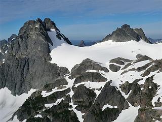 Look closer... 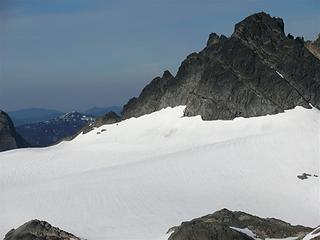 Closer... 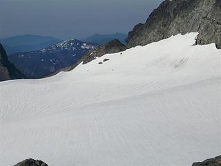 Closer... 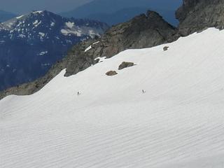 There! 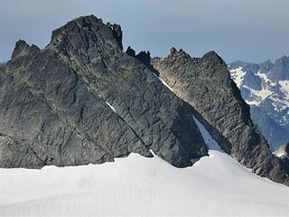 Stefan and Greg starting up the snow finger
"nothing's for certain" took the elevator down
while "anything can happen" climbed the stairs
- Ryszard Krynicki
"nothing's for certain" took the elevator down
while "anything can happen" climbed the stairs
- Ryszard Krynicki
|
| Back to top |
|
|
joker
seeker

Joined: 12 Aug 2006
Posts: 7953 | TRs | Pics
Location: state of confusion |
|
joker
seeker
|
Tue Aug 23, 2011 7:01 pm |
|
|
Nice job (and to you too, Martin!). I would love to get up there as part of a ski touring venture one of these days, though it sounds like there is still some non-skis travel at the top which may be intriguing in wintertime. Looks like a really cool vantage point.
|
| Back to top |
|
|
puzzlr
Mid Fork Rocks

Joined: 13 Feb 2007
Posts: 7220 | TRs | Pics
Location: Stuck in the middle |
|
puzzlr
Mid Fork Rocks
|
Tue Aug 23, 2011 11:36 pm |
|
|
Hard peak to top off on, unusual for the Cascades. Great work.
|
| Back to top |
|
|
Matt
Tea, Earl Grey, Hot

Joined: 30 Jan 2007
Posts: 4307 | TRs | Pics
Location: Shoreline |
|
Matt
Tea, Earl Grey, Hot
|
Wed Aug 24, 2011 12:52 am |
|
|
| Stefan wrote: | | Uh, there is a moat that probably goes down to sea level next to very steep wall. |
So, you didn't try it for an exit route?
 Approaching the snow finger
As beacons mountains burned at evening. J.R.R. Tolkien
As beacons mountains burned at evening. J.R.R. Tolkien
|
| Back to top |
|
|
Schmidt Alti-Babe
The Ice Queen
Joined: 11 Mar 2008
Posts: 606 | TRs | Pics
Location: Buried by backlogged pictures |
Amazing. Many times I have looked at that peak, wondering about the route. Thank you for the great description and grats on the summit!
|
| Back to top |
|
|
Stefan
Member
Joined: 17 Dec 2001
Posts: 5093 | TRs | Pics
|
|
Stefan
Member
|
Wed Aug 24, 2011 9:54 am |
|
|
|
| Back to top |
|
|
Stefan
Member
Joined: 17 Dec 2001
Posts: 5093 | TRs | Pics
|
|
Stefan
Member
|
Wed Aug 24, 2011 10:02 am |
|
|
| Matt wrote: | | So, you didn't try it for an exit route? |
Hey Matt, thanks for the picture here is some more detailed annotations on the route for people.
|
| Back to top |
|
|
Randy
Cube Rat

Joined: 18 Dec 2001
Posts: 2910 | TRs | Pics
Location: Near the Siamangs |
|
Randy
Cube Rat
|
Wed Aug 24, 2011 11:00 am |
|
|
I love it. Overcoat is one of my favorite peaks. Can't believe that webbing was still there and in good enough condition rap off. Thanks for the memories.
|
| Back to top |
|
|
Beave
Member

Joined: 21 Dec 2001
Posts: 276 | TRs | Pics
Location: Woodinville |
|
Beave
Member
|
Wed Aug 24, 2011 8:58 pm |
|
|
Sounds like a fun trip Stefan. Great use of time getting both peaks in one outing.
I just re-read my 7 year old TR..... LOL! Wow, I was dramatic. And I bet NASA made it to the moon with less directions than that.
Sorry my up-route description was killed by it's own detail, but glad you found our hand-line for the descent.
I agree with Randy; Definitely one of my favorite trips ever.
|
| Back to top |
|
|
Backpacker Joe
Blind Hiker

Joined: 16 Dec 2001
Posts: 23956 | TRs | Pics
Location: Cle Elum |
Well would you look at that. Randy AND the Beave posting in the same thread. Both of you guys have been ghosts around here for some time.
Nice to see youre still alive. Lol.
"If destruction be our lot we must ourselves be its author and finisher. As a nation of freemen we must live through all time or die by suicide."
Abraham Lincoln
"If destruction be our lot we must ourselves be its author and finisher. As a nation of freemen we must live through all time or die by suicide."
Abraham Lincoln
|
| Back to top |
|
|
Tom_Sjolseth
Born Yesterday

Joined: 30 May 2007
Posts: 2652 | TRs | Pics
Location: Right here. |
We wound up doing a pretty much identical trip this past weekend, except we descended the E Face of Overcoat. We were able to down climb nearly the entire route except for one short rappel at the base of the diagonal ramp getting back onto the snow. This was my first time in the area, and I really enjoyed it - thanks for the motivation to get in there!
| Stefan wrote: | 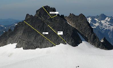 We descended the route in the center. |
I doubt that our descent route gets done much since it's loose, there are no rap stations or any webbing whatsoever, and there are very few places for pro on the steep, slabby lower portion. Rappel anchors were tough to come by - knife blades would come in handy. We left a sling near the bottom after looking for reliable rappel anchors for about 20 minutes. I would recommend just down climbing the NE Gully instead. At this time, the upper portion is getting close to being alpine ice (right where it steepens) and is almost impenetrable with aluminum crampons.
|
| Back to top |
|
|
|
|


