| Previous :: Next Topic |
| Author |
Message |
Aubrey
Member


Joined: 29 Aug 2011
Posts: 24 | TRs | Pics
Location: Bellingham |
|
Aubrey
Member
|
 Thu Sep 15, 2011 11:31 am |
|
|
Summit Elevation: 5,964
Date Climbed: 9/2/11
Round-trip Distance: 10.6 miles
Total Elevation Gain (including some ups and downs): about 3,500 feet
I have only been climbing mountains in the North Cascades for about a year now, after moving to Bellingham from Colorado last year, but the more I experience the range, the more I love it. Its much more rugged, remote and diverse than I had ever expected.
On Sept. 2, my wife (Jen) and I got another delicious taste of what it has to offer.
I think the entire drive to the Trappers Peak trailhead, including the 5-mile-long gravel road, took us about two hours from Bellingham. There was only one other car (from Canada) at the trailhead when we got there.
The trail starts off with a gentle grade on a decommissioned logging road. But it isnt long until it turns into a classic, Pacific Northwest trail thats covered with roots and rocks. And the occasional water crossing, of course.
Jen crossing a stream:
Just as the trail started to steepen even more, we ran into a couple guys from British Columbia who had camped at Thornton Lakes the night before. After a short chat with them, one of the guys told us, This is where the grinders start.
Were there going to be delicious sandwiches on this trail? I wondered.
The term grinders was not in my mountain vernacular, but as my wife and I huffed and puffed up the trail, we figured it meant a steep section of switchbacks. As in, its a real grind. Correct me if Im wrong, though.
Regardless, it gave us a good laugh, and it reminded us of the first time we heard the term ducks while hiking in Glacier National Park many years ago. Some Canadian guy was describing a route to us, and he said, When you see the ducks, take a left. I walked away thinking he was a whack job. (We later learned that ducks = cairns.)
As we pushed up the mountainside toward the pass, the views started to open up.
Trailside lupine in full bloom:
Sometimes the best views in the mountains are up close:
Once we gained the saddle, I was blown away by the view of the Thornton Lakes, the slabby cirques across the way, and the formidable-looking Trappers Peak. Its nearly vertical southwest face shoots up about 1,400 feet above the lake, and just looking at it made my palms sweat. The swirling clouds made it seem even more menacing. But it was still beautiful.
Heres a three-photo pan of Thornton Lake, Mount Triumph and Trappers Peak, viewed from the saddle:
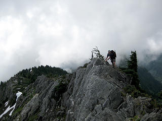
I expected to encounter some scrambling, but I was surprised by the Class 2 dirt scramble we had to endure through a thicket of bushes. Fortunately, it wasnt long before we got to real rock. Some of it was loose, though, so we had to climb cautiously so as not to kick rocks on each other.
Heres Jen starting up the first steep section:
For the most part, there was a good trail (or braided trails) to follow, but whenever it became unclear, we just stayed high on the ridge.
Im just fine on exposed, solid rock, but Im not the biggest fan of steep dirt/grass trails that are right above cliffs. There were a couple sections like this and they got my heart pumping a little, but none of it was that bad.
Multi-photo pan of the route before us:
The trail got a little narrow in some spots, but none of it was overly difficult or overly scary, so long as you watch your steps.
To our surprise, there was one airy section, which had what Id call a butter knife edge. Even though it had a little exposure, the rock was totally solid and it wasnt very difficult to cross.
 short scramble on Trappers 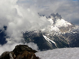 Pickets from Trappers 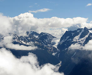 view from Trappers Peak ... not sure what glacier this is across the way  Newhalem from Trappers Peak 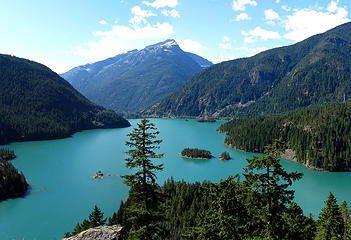 Diablo Lake  Winthrop WA 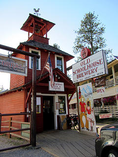 Old Schoolhouse Brewery
|
| Back to top |
  
|
|
Dani
Kimtah's Mom

Joined: 01 Jul 2008
Posts: 136 | TRs | Pics
|
|
Dani
Kimtah's Mom
|
Thu Sep 15, 2011 12:08 pm |
|
|
Welome Welcome! Lucky you to be living in Bellingham. I love it up there.Great report I have not been to this peak in years and now I know I have get back! 
Keeping GeoTom in line since 1998
Keeping GeoTom in line since 1998
|
| Back to top |
|
|
kyle d
Member

Joined: 03 Jun 2007
Posts: 521 | TRs | Pics
Location: Ogden, UT |
|
kyle d
Member
|
Thu Sep 15, 2011 12:48 pm |
|
|
Hey, nice to see you on nwhikers. Great first trip report. I really like that "deep valley" shot.
|
| Back to top |
|
|
jverschuyl
Member
Joined: 12 Aug 2011
Posts: 10 | TRs | Pics
Location: Skagit |
|
| Back to top |
|
|
Burke M
over-caffeinated

Joined: 09 Sep 2010
Posts: 699 | TRs | Pics
Location: Seattle |
|
Burke M
over-caffeinated
|
Thu Sep 15, 2011 4:49 pm |
|
|
Welcome to the site!
Love the color in the photos nice job. Looks like a great trip! 
|
| Back to top |
|
|
Elvis
Shuffl'n
Joined: 09 Jun 2004
Posts: 1804 | TRs | Pics
Location: del Boca Vista |
|
Elvis
Shuffl'n
|
Thu Sep 15, 2011 9:28 pm |
|
|
Great report and pics!
Was going to head there a couple weeks ago... still hoping to hit that one this year.
Your pics really helped to show the route & terrain - thank you!
What is the road like? I've heard steep... pot holes? washboards? sharp rocks?
Happy Trails!
~E
"Ill habits gather unseen degrees, as brooks make rivers, rivers run to seas." ~John Dryden
My Trip List
"Ill habits gather unseen degrees, as brooks make rivers, rivers run to seas." ~John Dryden
My Trip List
|
| Back to top |
|
|
Snowdog
Member

Joined: 21 Jul 2006
Posts: 1028 | TRs | Pics
Location: on (& off) the beaten path |
|
Snowdog
Member
|
Fri Sep 16, 2011 11:53 am |
|
|
another Welcome, and great report. I have this trip on my 'to do' list and your intell helps alot. Might do it as an overnite & stay at the lake after bagging the peak. Sound like a good plan to you?
'we don't have time for a shortcut'
'we don't have time for a shortcut'
|
| Back to top |
|
|
Aubrey
Member
Joined: 29 Aug 2011
Posts: 24 | TRs | Pics
Location: Bellingham |
|
Aubrey
Member
|
Fri Sep 16, 2011 2:19 pm |
|
|
Thanks for the warm welcome and kind words, everyone. This is a great site. I'll surely post more ...
Elvis, the road wasn't bad. Some washboards and slightly steep in some sections. A few potholes here and there, too, but nothing that bad. A 2WD sedan was at the trailhead.
Snowdog, we didn't go down to the lake, but it seems like it would be a cool place to camp. Great alpine views. Just keep in mind, you'll lose about 500 feet from the saddle, which you'll have to regain on the way out. On your way to the peak, you might want to consider stashing all your camping gear near the saddle (and pick it up on your way back down to camp). That way you won't have to lug it up 900 feet to the summit.
|
| Back to top |
|
|
|
|
You cannot post new topics in this forum
You cannot reply to topics in this forum
You cannot edit your posts in this forum
You cannot delete your posts in this forum
You cannot vote in polls in this forum
|
Disclosure: As an Amazon Associate NWHikers.net earns from qualifying purchases when you use our link(s). |


