| Previous :: Next Topic |
| Author |
Message |
ShakeyJke
Member


Joined: 20 Aug 2010
Posts: 18 | TRs | Pics
|
Updated! I got off my lazy butt and added pictures!!
This is my first trip report so Ill try to keep it fun. I have to apologize as I don't have a photo sharing platform but I linked the YT videos for each day below for those of you who want to watch. Hope You enjoy
Route: Counterclockwise starting on the north side of Mt. Adams
Miles: ~53+
Planned # of days: 9
Actual # of days: 7
# of "misplaced" hikers encountered: 7
Pack weight: 47 lbs (with food & water, 32 oz)
Gear extras: Crampons, Ice axe, 0` bag, River crossing shoes, Heavy coat.
Day 1: Muddy Meadows to Killen Creek Camp
We left town Friday afternoon and made the long drive down to Randle where we picked up our appropriate permits for our adventure. At the Ranger station they told us a small fire sparked by lightning was burning in the area of Green Forest Camp not far from Muddy Meadows, our preferred point of entry. The fire was fairly small and they said the fire crew had it contained, but to be ready to adapt to possible changes.
We left Randle and headed down the forest service roads to the trailhead. Here the fire crew had its trucks and some equipment there, as well as some crew members getting ready to head out. This gave us an opportunity to talk with them and get some firsthand info on the fire, they were generous in both their time and details they shared with us. Thanks guys!
With their info we decided that we would continue with our plans and we found a good spot to park the truck. At our parking spot a group of bow hunters came over and chatted with us. We had a good time talking with them for a few and as they would be camping here for a few days it made me feel better about leaving my truck at this site.
Our boots finally hit the trail at a little before 6 pm. The trail starts off flat at about the 4400 foot line and meanders through the meadows and forest. Soon enough it begins to gain elevation but views are only of the surrounding forest. While the trail is sandy its not dusty today, but the bugs are thick and evil.
After 2 1/2 miles we reach the intersection of Trail 13 and the PCT, here the next section of Trail 13 is blocked off due to the fire burning. We hang a right and head up the PCT towards Killen Creek Camp. The terrain changes from closed in forest to a more open space. The forest is thinner and the ground is rockier, while the ridge to our left begins to take shape and define itself. The sun begins to set on us and we stop for a snack and get our headlamps ready. We have good views to our right and watch a nice sunset. As we continue on, we spooked a couple of elk grazing in a small dell.
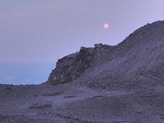
As we hike it becomes darker, but just before we have to use our headlamps the full moon starts to rise and lights up the forest. This was my first time backpacking in the evening under a full moon, and it was awesome!
The trail took us quickly to the meadows of Killen Creek Camp, and we could see a group camped below the waterfall. We quietly took the site in the trees to the east of the stream. After we started dinner we set up our sleeping arrangements, Jim put his footprint down and put his fly on top while I put my footprint down and just put my pad and bag on top. The bugs disappeared for the night so we had a good nights sleep. This was also the first time I have chosen to sleep outside of my tent and it was a very nice experience, as I could see the moon and its different positions when I woke up sporadically, and I just generally felt more in tune with my surroundings.
DAY 2: Killen Creek Camp to Horseshoe Meadows
As the moon began to set, the sun was beginning to light the sky, meanwhile we began to get our breakfast cooked. After a meal of oatmeal and hot chocolate I began to pack my gear. The other group camped below the waterfall broke camp and headed out before us, one by one they headed out on the trail until all twelve of them disappeared around the bend.
During our hike yesterday afternoon, Jim began to develop heel blisters on both of his heels. Although we stopped so he could attend to them, the boots he was wearing were making them worse with each step. This morning Jim had time to bandage them up and decided to hike in his trail shoes.
Soon enough we started on our way, excited to be moving into areas we haven't hiked before. The trail stays at roughly 6000 feet for the next 11 miles, but there are plenty of ups and downs to keep a person busy. Views include the mountain to your left and the cascade range to the left, but the sky is hazy and Mt. Rainer is barely visible.
After about 3 miles of hiking in the morning we come across a couple who are hiking the PCT and we have a quick chat with them. They have just crossed the Lewis River and they warned us of poor crossing as one of them had lost their footing and got a cold morning bath.
At the river we could see that the crossing point was less than desirable, but the water was low and we could wade across. We put on our crossing shoes and Jim went first, "Its refreshing!" he called out as he was part way across. By 3 more steps he changed his tune, "Oh, man! That's cold!" Yup, wading across was so cold it was painful.
With our shoes thoroughly filled with sediment, we stopped on the south side of the river in the trees to dry off, change back into our boots and have an early lunch. By this time the mosquitoes were terrible and it made for an unpleasant lunch. My preferred method of avoiding being bitten is by wearing a lightweight long sleeve shirt and lightweight gloves, but a few persistent devils broke through my defenses and got a meal.
Back on the trail we leisurely made our way around the west side of the mountain, passing streams and a small lava field. The terrain would change from open views of both the mountain and the Cascade Range to forests with only territorial views. We crossed paths with several groups of both hikers and hunters in this stretch of trail.
After passing by Sheep Lake the trail moved through wildflower fields with them in full bloom. Between Sheep Lake and The Hump we stopped to break, as we were tired and needed some food. We mistakenly assumed that we were about a mile and a half away from Horseshoe Meadows, when in reality we were about 3 miles away. So needless to say, the next "mile and a half" was the longest "mile and a half " we have ever hiked. But after some time we reached the intersection of the PCT and Trail 9, and Horseshoe Meadows was just a stones throw away.
There was a group of day hikers meandering around the meadow while we picked a spot to camp for the night. The mosquitoes were out in force so both Jim and I set up our tents, but without the fly's. After setting up our tents we took refuge in them and had a nap. I think I slept for about 30 min before I woke up, but I felt well rested and ready to cook dinner.
The steam that runs through the meadow is cloudy and somewhat warm compared to the other steams coming off of the mountain. Although I filtered it, it was my least favorite spot to get water. I cooked my dinner while Jim slept and the mosquitoes swarmed around me trying to get their dinner. By this time the sun was dropping close to the horizon and I left camp to go check out a waterfall that I could hear at the far side of the meadow. The meadow showed tracks of elk, deer, and goats, while in the distance the mountain rose up and dominated the skyline.
By the time I got back to camp the sun had set and the sky was getting darker. I woke Jim up so he had a chance to cook and eat his dinner. The bugs had disappeared by this time and we were once again greeted by the rising moon. Soon enough it was time to retire for the night and we drifted off to sleep. During the night we awoke and saw some deer grassing not far off in the meadow, they didn't seem to mind us and we let them be.
DAY 3: Horseshoe Meadows to Lunch Counter;
With a big day ahead of us we woke up just as the sky was beginning to lighten, we ate breakfast and packed our gear up and headed out of camp. The sun was just beginning to rise when we got out on the trail. We passed along small meadows filled with wildflowers and the bugs are pleasantly absent today. Soon enough the landscape changes again and steep slopes rise to our left and fall off to our right, allowing for good views of the far off ranges. There are lots of streams to cross but they are pretty small and don't present a challenge.
Just about the time we crossed a stream, we rounded a bend in the trail and encountered two people. They ask us if we are lost, they are S&R and are looking for two snowboarders who came off of the wrong side of the mountain and are overdue. We had only seen one lady who was taking photographs earlier in the day. We told them where we came from and about what time we moved through the area. The S&R team continued on and we stopped to eat lunch. Today we lingered about much longer than we normally do and probably didn't leave the area until about an hour later. Just as we got our packs on I could hear distant voices, I looked up on a ridge as that was the direction on the sounds. Sure enough, we spotted two people on a steep talus ridge right above a cliff face. They were clearly in a bad area and didn't know which way to go as they moved up and down the ridge.
We immediately assumed that it was the missing snowboarders, and Jims cell phone had service oddly enough. He made the call to try to get in touch with the S&R coordinators , but was having much trouble with the dispatch people just pawning him off to different departments. After about 6 transfers and repeating what he knew he finished up the phone call. It seemed like a lot of confusion on the part of the authorities, but that's just my take on it.
As Jim was wrapping up the call, two more hikers approached us and asked us if we knew where we were. I asked them if they were S&R but they said no, they had made the summit earlier in the morning but had descended down the wrong way and found their way to Trial 9. I showed them the map and they were fairly close to the South Climb trail intersection. They thanked us and made their way down the trail while Jim and I got ready to start our second leg of the day.
We reached the South Climb trail intersection fairly quickly and started our way up. Today is Sunday so we passed several dozen people coming down off of the mountain.
At about the 7000 foot line we stopped for a break so Jim could tend to his blisters. On a ridge to our left we could see about a dozen or so people who were not on the right path looking for a way down to the trail, some braved the loose rock and scrambled down while others backtracked their steps and found the correct route to descend.
After some time we started back up the trail, while the sun baked the surrounding rocks.
Jims blisters were giving him a rough time and our progress was slow but steady. We soon reached the finger of the Crescent Glacier and ascended it, while another group was making their descent. We continued up and passed some rock shelters but our goal for the day was Lunch Counter at 9400 feet. At about the 8400 foot line a group of rock shelters huddle in a small flat area. Jim needed to tend to his wounds, meanwhile I decided to continue on and look for a campsite area that has running water. While I climbed up a few more hundred feet, I passed the last people coming off of the mountain and they said we had the area all to ourselves.
The afternoon was moving into late day as we looked up at the snowpack that leads up to Lunch Counter. From our perspective it looked like a reasonable distance but with a crest that we believed to be Lunch Counter, we decided to make for it. We put on our crampons and started up the snowpack, only to realize that distances are not easily defined while looking across a white landscape.
It took some amount of time to climb up to the crest we saw from below, and we could see that we were only about half way up the snowpack. We were committed now, and the sun began to dip behind the mountain. Jims blisters were slowing him down and I put some distance between us trying to scout for our destination. After some time I reached a hole in the snowpack with water flowing just below. I signaled Jim and he took a rest in the rocks while I filled my water bottle and continued on. Lunch Counter was only a short distance away, and I quickly made tracks for it and dumped my gear in a rock shelter. I grabbed a snack and headed down to meet Jim. He was nearing the water when I reached him, and he was happy to see that we were close. We finally rolled into camp just before dark and set up our camp. After 9 miles and 3100 feet in elevation gain in the last 3 miles we were pretty tired and crashed out with only a snack for our dinner.
Once again the moon began its path just after the sun had dropped below the horizon.
DAY 4: Summit
I woke up before dawn and could see some headlamps on the mountain as people were making their way up to Pikers Peak. Jim woke as I was fixing my breakfast and he began to get ready. It was our goal to climb the mountain this year, but I was unsure if Jims blisters would allow him to do so. He got up and got ready for our attempt and we headed out as daybreak approached.
Once we started to make our ascent it became apparent that Jim wouldn't be able to summit. He swallowed his pride and knew he needed to rest his blisters, he waved me on and headed back to camp as he worked through his disappointment. I resumed my climb and settled into a rhythm of about 50 steps and then rest. I zigzagged my way up following the path of least resistance, meanwhile I could see Jim down towards camp.
Pikers Peak is also called the false summit as this is the point a person sees as they are climbing the south climb. After some time I crest Pikers Peak and I can see the summit in the distance. The wind is blowing very hard and I have to put my hand in front of my mouth so I can get a breath of air.
There is a relatively flat area between the false summit and the beginning of the final climb to the true summit. I quickly traverse this distance and soon I am looking at my options for the final ascent. On one side I have a nasty talus slope with loose rocks and no defined trail and to my left I see a snowpack riddled with sun cups and icy patches. I chose the scramble up the loose rock, and it turned out to be a very annoying section of the climb. After this section, it is a short distance to the top. I met two other people up there and we had a short chat and I took some pictures and had a snack.
Reaching the summit was actually anti-climatic, in fact as I was eating my snack I was bummed that I didn't have anyone to share the experience with. This is not to say that I didn't appreciate the effort put forth or the beauty of the area, but it was the journey here that had more meaning than the actual time at the summit.
I stayed for a few but headed back down soon enough. The decent down to Pikers Peak was quick and I looked into the glissade chutes. They were intimidating to look at as they had the appearance of bobsled chutes. I decided to give it a try, my goal was to keep it slow and controlled as I could not afford to sprain or break something....I had a few more days on the mountain to enjoy.
I sat my butt in the death chute and readied my ice axe......3,2,1....and I'm off. My glissade was mostly controlled with only a couple of times where I felt I didn't have complete control. My descent was quick but wet and cold on my butt, and soon enough I could see camp.
Jim was there doing laundry and was in good spirits despite his disappointment. We chatted and he wanted to hear all the details. We decided to stay at the camp for another night and we would move out in the morning. While we hung out at camp we could see other people descending the mountain. Some were glissading down and you could see they were not in a controlled state. One person blasted down a chute and into rocks to their right, it looked like they avoided serious injury as they were able to get up and try it again....gluttons for punishment.
I had a short nap at around midday while Jim putted around camp. Tomorrows destination goal is Sunrise Camp. Sunrise Camp is only about a mile and a half away if we can descend the Mazama Glacier, but if we cant, we must head back down the south climb trail, hang a left at Trail 9 and make our way through Bird Creek Meadows up to the Hellroaring Canyon viewpoint an finally up to Sunrise Camp, a distance of about 11 miles and dropping down to 6000 feet only to climb back up to 8300 feet.
I decided to go scout the Mazama Glacier as there is easy access to it from our location. I climbed over to it and could look strait down on the vacant Sunrise Camp. Large Crevasses cut through the Mazama blocking our route. A more experienced climber may well have had no trouble finding a route but as for us.....we choose life.
I headed back to camp to let Jim know we cant just drop into our next camp area. There is still plenty of time in the day and Jim heads out to explore the surroundings while I eat an early dinner. As evening set in we went to bed fairly early.
DAY 5: Lunch Counter to Sunrise Camp; The long way around
It froze during the night and our water hole is nearly iced up completely. After breakfast we begin what we know will be another long day on the trail. As we head down we pass only a couple of groups of people making their morning ascent attempt.
The climb down was pretty uneventful and soon we reached Trail 9 and headed east. After moving through a lava field the terrain opened up into small meadows filled with different kinds of wildflowers and small streams meandered through them quietly. This is a very beautiful area and we met a couple groups of people who also had the opportunity to enjoy the area.
Once again a group asked us if we knew where we were, and we showed them the map and got them moving in the right direction. We made our way up to the Hellroaring Canyon Viewpoint and ate lunch at this amazing spot. Its now nearly 3pm and we leave the maintained trail and begin to work our way up to our destination. The boot path disappears into the snow fields and goat paths head this way and that way. There is a large steep talus ridge that rises in front of us that we dub the Razorback. We spot the trail as it switchbacks up the lower tail of this ridge.
Poor footing and loose rocks are its trademarks and climbing up to the spine is slow as we try not to kick rocks loose. We finally reach the spine and begin to climb up to the peak of this nasty ridge. To our right a alpine lake is nearly hidden below snowpack and to our left the ridge drops off just as sharply into a meadow. At the peak of the ridge we can see out across the lower portion of the Mazama and we can see the saddle where Sunrise Camp is nestled. From here we weigh our options for our route and also if we can make it to camp before dark.
The sun is dipping below Suksdorf Ridge as we work our way down the ridge and onto the lower Mazama. Our route will take us close to rockfall zones and we will need to move through the area quickly. This section of our route is easy enough and we make good time. At about the 8000 foot line we encounter crevasses both exposed and ones we can see that are hidden or at least areas that don't appear to be stable.
There are large areas of rocks jutting up out of the glacier also ones that are piled up upon the glacier. We decide to scramble along these and avoid the glacier when we can, so we leapfrogged our way closer to Sunrise Camp.
Just as the suns light was disappearing for the evening we crested our last rock pile and spotted camp not far off. We were very happy and make quick work of the last bit of scrambling we needed to do. The wind at this time was picking up quite steadily and we setup or camp as quickly as we could. It was dark by the time we cooked our dinner but like the other nights the moon shined down upon us.
Tomorrow we will move into the Gap, so tonight we rest.
 Sunrise Camp at Dusk 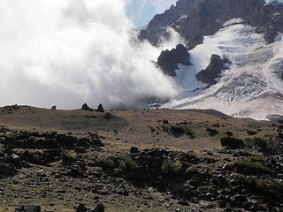 Devils Garden 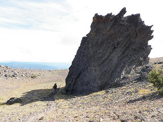 Just below Devils Garden
|
| Back to top |
  
|
|
silence
Member

Joined: 25 Apr 2005
Posts: 4420 | TRs | Pics
|
|
silence
Member
|
 Tue Oct 04, 2011 5:41 pm |
|
|
man .. i have wanted to do this ever since we climbed adams .. no time to read it now .. but i will be back ... excited!
PHOTOS
FILMS
Keep a good head and always carry a light bulb. Bob Dylan
PHOTOS
FILMS
Keep a good head and always carry a light bulb. Bob Dylan
|
| Back to top |
|
|
NWtrax
Member

Joined: 27 Apr 2008
Posts: 638 | TRs | Pics
|
|
NWtrax
Member
|
Tue Oct 04, 2011 8:41 pm |
|
|
well told adventure! encircling and standing atop one of these great volcanos seems like an utmost rewarding approach. thanks for joining and sharing your incredible trip.
|
| Back to top |
|
|
Magellan
Brutally Handsome

Joined: 26 Jul 2006
Posts: 13116 | TRs | Pics
Location: Inexorable descent |
|
Magellan
Brutally Handsome
|
Tue Oct 04, 2011 9:40 pm |
|
|
A really well told story about a rarely done circumnavigation. Thanks for sharing. 
|
| Back to top |
|
|
Slugman
Its a Slugfest!

Joined: 27 Mar 2003
Posts: 16874 | TRs | Pics
|
|
Slugman
Its a Slugfest!
|
Tue Oct 04, 2011 10:46 pm |
|
|
That was a fun read. Very well told. I didn't watch the videos, but I will. Thanks for posting.
|
| Back to top |
|
|
mtn.climber
Member

Joined: 29 Jul 2008
Posts: 1204 | TRs | Pics
Location: The Lost Horizon |
I enjoyed your story. Good job!!
Reach for the sky, cuz tomorrow may never come.
Live the life of love. Love the life you live.
Reach for the sky, cuz tomorrow may never come.
Live the life of love. Love the life you live.
|
| Back to top |
|
|
Bedivere
Why Do Witches Burn?

Joined: 25 Jul 2008
Posts: 7464 | TRs | Pics
Location: The Hermitage |
|
Bedivere
Why Do Witches Burn?
|
Wed Oct 05, 2011 12:43 am |
|
|
TTIWOP!  Not really, that's a very good read. Excellent report and adventure! Next time, put some pictures up though!
|
| Back to top |
|
|
silence
Member
Joined: 25 Apr 2005
Posts: 4420 | TRs | Pics
|
|
silence
Member
|
Wed Oct 05, 2011 7:48 am |
|
|
awesome .. very well written tr .. photos would have been sweet .. but your story really told it beautifully ... nice work with the video too ...
the "gap" -- i thought it was called the "killer gully" or something like that -- certainly lived up to its name .. it was just as i imagined so i always figured we wouldn't even attempt this till fall .. of course this year's fall is more like early aug .. anyhow i'm glad you were able to find a way across and everyone came home safe .. congrats on a trip well done!
btw how did you deal with crossing the yakima land? i thought we have to get a permit from them too?
PHOTOS
FILMS
Keep a good head and always carry a light bulb. Bob Dylan
PHOTOS
FILMS
Keep a good head and always carry a light bulb. Bob Dylan
|
| Back to top |
|
|
ShakeyJke
Member
Joined: 20 Aug 2010
Posts: 18 | TRs | Pics
|
HA! That will teach me! I got the point and added some of my better pics....I left the fuzzy ones out 
|
| Back to top |
|
|
silence
Member
Joined: 25 Apr 2005
Posts: 4420 | TRs | Pics
|
|
silence
Member
|
Wed Oct 05, 2011 9:53 am |
|
|
sweet ..
can you plez answer the question about the yakimas .. or pm me with it .. thx!
PHOTOS
FILMS
Keep a good head and always carry a light bulb. Bob Dylan
PHOTOS
FILMS
Keep a good head and always carry a light bulb. Bob Dylan
|
| Back to top |
|
|
ShakeyJke
Member
Joined: 20 Aug 2010
Posts: 18 | TRs | Pics
|
|
| Back to top |
|
|
rbuzby
Attention Surplus
Joined: 24 Feb 2009
Posts: 1011 | TRs | Pics
|
|
rbuzby
Attention Surplus
|
Wed Oct 05, 2011 3:34 pm |
|
|
Way to circumnavigate! Nice report.
Rusk creek and glacier must be named for C.E. Rusk, one of the early pioneering mountaineers. He was among the first to circumnavigate Adams. His book Tales of a Western Mountaineer is a classic. A progenitor of Challenge of the North Cascades.
|
| Back to top |
|
|
Slugman
Its a Slugfest!

Joined: 27 Mar 2003
Posts: 16874 | TRs | Pics
|
|
Slugman
Its a Slugfest!
|
Wed Oct 05, 2011 3:51 pm |
|
|
Pictures.  
|
| Back to top |
|
|
Jason Hummel
Member
Joined: 31 Aug 2006
Posts: 1209 | TRs | Pics
Location: Tacoma Washington |
This is a beautiful area. Way to get out there to enjoy it.
|
| Back to top |
|
|
Bedivere
Why Do Witches Burn?
Joined: 25 Jul 2008
Posts: 7464 | TRs | Pics
Location: The Hermitage |
|
Bedivere
Why Do Witches Burn?
|
Wed Oct 05, 2011 10:23 pm |
|
|
Those pictures: Niiiiiiiiiiiiiiiiiicccccceeee!!!
|
| Back to top |
|
|
|
|
You cannot post new topics in this forum
You cannot reply to topics in this forum
You cannot edit your posts in this forum
You cannot delete your posts in this forum
You cannot vote in polls in this forum
|
Disclosure: As an Amazon Associate NWHikers.net earns from qualifying purchases when you use our link(s). |


