| Previous :: Next Topic |
| Author |
Message |
Hulksmash
Cleaning up.


Joined: 20 Apr 2008
Posts: 7113 | TRs | Pics
Location: Arlington |
|
Hulksmash
Cleaning up.
|
 Sun Feb 12, 2012 10:43 pm |
|
|
Why? Why is this trail abandoned? This trail begins in a well developed campground it is an enigma to me how this one was let go without howls of protest. The campground now quiet, it gets few visitors during the last few years, because it is up the Suiattle River road. Eventually the road will be repaired and campers will once again fill the campground. The potential for a nature walk through magnificent old growth forest is great. But will it ever be realized? This creek drainage is not particularity brushy in the form of salmon berry or devils club. It's there but not in dense patches. Instead, there i lush coat of sword fern and moss. Of course it has all the issues any abandoned trail suffer from. Blow downs, slides, and places its just plain difficult to find.
To get there park at the Suiattle river road gate. Walk, bicycle to the Buck Creek camp ground.
Find camp site #9.
or these twin posts.
At first it seems like a braided boot path. But then there signs of trail structures.
This is a dead giveaway.
Here is some of the better portions of trail.
I did not have time to explore the entire length of trail. Another day.
View larger size in new window
"Bears couldn't care less about us....we smell bad and don't taste too good. Bugs on the other hand see us as vending machines." - WetDog
Albuterol! it's the 11th essential
"Bears couldn't care less about us....we smell bad and don't taste too good. Bugs on the other hand see us as vending machines." - WetDog
Albuterol! it's the 11th essential
|
| Back to top |
  
|
|
Magellan
Brutally Handsome

Joined: 26 Jul 2006
Posts: 13116 | TRs | Pics
Location: Inexorable descent |
|
Magellan
Brutally Handsome
|
Sun Feb 12, 2012 11:39 pm |
|
|
I remember walking it as a boy of single digit age. As an adult I wondered how far it used to go.
|
| Back to top |
|
|
Riverside Laker
Member

Joined: 12 Jan 2004
Posts: 2819 | TRs | Pics
|
I have a theory after finding some an interesting abandoned trail high on Huckleberry Mtn NW of the end of the Buck Creek trail. If I recall, the abandoned trail (obviously built) went to a creek at about 4000'. Follow the Huckleberry trail east from a switchback... shuck... I can't remember it all that well... going senile... But then again, maybe this abandoned segment I found was a water source for the lookout on Huckleberry. But my weak theory was it went down to Buck Creek.
There also used to be a trail to Huckleberry's west summit. I never looked for that one.
|
| Back to top |
|
|
Hulksmash
Cleaning up.
Joined: 20 Apr 2008
Posts: 7113 | TRs | Pics
Location: Arlington |
|
Hulksmash
Cleaning up.
|
Mon Feb 13, 2012 12:42 am |
|
|
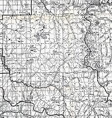
Hummm. I do believe your theory is correct. Check out this 1941 Map
I wonder if that was the original route to Huckleberry?
"Bears couldn't care less about us....we smell bad and don't taste too good. Bugs on the other hand see us as vending machines." - WetDog
Albuterol! it's the 11th essential
"Bears couldn't care less about us....we smell bad and don't taste too good. Bugs on the other hand see us as vending machines." - WetDog
Albuterol! it's the 11th essential
|
| Back to top |
|
|
Kim Brown
Member

Joined: 13 Jul 2009
Posts: 6900 | TRs | Pics
|
There were lots of trails leading into that area from the west and north. The Illabot watershed and the North Lakes area and over to the Middle Fork Cascade, and east to Huckleberry was laced with trails. I would love to find some old cut logs or puncheon up there.
I didn't realize the Buck Creek trail was ever a built trail, though. Neat to see that puncheon and tread. I've only gone up about 1/2 a mile - to the boulder fields. I don;t recall noticing it was an old built trail. I was in a hurry (long story) and I didn't really care much about old trails back then.
Hulk, let's head up Fire Creek trail this summer. You want to see ancient puncheon....there's your ballgame. 
"..living on the east side of the Sierra world be ideal - except for harsher winters and the chance of apocalyptic fires burning the whole area."
Bosterson, NWHiker's marketing expert
"..living on the east side of the Sierra world be ideal - except for harsher winters and the chance of apocalyptic fires burning the whole area."
Bosterson, NWHiker's marketing expert
|
| Back to top |
|
|
lopper
off-route

Joined: 22 Jan 2002
Posts: 845 | TRs | Pics
|
|
lopper
off-route
|
Mon Feb 13, 2012 9:26 pm |
|
|
Hey, you guys are speaking my language.
Here is what the 1931 Mt Baker NF map has to say:
 1931
|
| Back to top |
|
|
xan
Member
Joined: 31 Mar 2007
Posts: 222 | TRs | Pics
|
|
xan
Member
|
Sun Feb 19, 2012 5:20 pm |
|
|
I rather doubt the Buck Creek trail was ever *the* trail up Huckleberry mtn. Why would you climb steeply out of the lowermost buck creek valley when you could climb much more gradually and consistently out of the main Suiattle valley (the current trail alignment)?
I am also convinced the trail never went very far up Buck Creek. Creekside options peter out roughly where the trail stops. You can either climb a few hundred feet up ledgy hillside before traversing or swim up the creek-bed. And beyond this gorge-y section buck creek remains a quite difficult valley, with a lot of valley-spanning brush; best of a difficult set of choices is right in the creek-bed and that is really only a low-water option.
Travel on the alpine/subalpine ridgelines paralleling buck creek is a lot easier (the huckleberry mt ridge or the green mtn ridge); another reason why I doubt it would have occurred to anyone to force a trail up there.
I think stub trails like buck creek (or e.g. sulfur creek), which don't involve views, however pleasing to nature contemplatives, tend to have few vocal constituents. So they end up on the block when something has to go because of funds constraints.
One can still go up there, of course. It seems like a nice I-don't-want-to-deal-with-snow option, as you discovered.
|
| Back to top |
|
|
Kim Brown
Member
Joined: 13 Jul 2009
Posts: 6900 | TRs | Pics
|
The trail gets use by campers at Buck Creek. Not as much nowadays as when the road was open, of course.
I poked around the older car campground a couple summers ago, and followed an old footpath from there but got cliffed out fairly early on. So I bet even before the current car campground was built (early 1980s?) that the trail Hulk was on was the exploration trail from the old campground users as well.
I understand Sulphur Cr trail went quite a bit farther years ago. I have no idea why it would. I tried bashing beyond the hot springs but after about 20 minutes, gave up. It was killing me.
"..living on the east side of the Sierra world be ideal - except for harsher winters and the chance of apocalyptic fires burning the whole area."
Bosterson, NWHiker's marketing expert
"..living on the east side of the Sierra world be ideal - except for harsher winters and the chance of apocalyptic fires burning the whole area."
Bosterson, NWHiker's marketing expert
|
| Back to top |
|
|
Schroder
Member

Joined: 26 Oct 2007
Posts: 6722 | TRs | Pics
Location: on the beach |
|
Schroder
Member
|
Mon Feb 20, 2012 8:14 am |
|
|
| Kim Brown wrote: | | I understand Sulphur Cr trail went quite a bit farther years ago. I have no idea why it would. I tried bashing beyond the hot springs but after about 20 minutes, gave up. It was killing me. |
From Harry Majors:
The old Sulphur Creek Trail represents one of the most historically significant trails in the North Cascades, for it follows the traditional route by which the Sauk, Suiattle, and Chelan Indians crossed the Cascade Crest via Kaiwhat Pass. Railroad surveyor Daniel C. Linsley followed this route up the Suiattle River and Sulphur Creek in June 1870, during his search for a feasible crossing point for the Northern Pacific. Years later, in July 1938, it was via the Sulphur Creek Trail that the original four Ptarmigans began the first Ptarmigan Traverse, camping that first night out "on an island in the middle of the creek" (1958 Mountaineer, p. 56). At this time, the Sulphur Creek Trail offered the shortest approach route to Dome Peak.
Buck Creek was surveyed in 1916 but the map doesn't appear to be on file with the BLM. That would show the trails of the time. It's TWP 32 N R 11 E, if someone else wants to look for it. IMO that was just a short nature trail developed with the campground.
|
| Back to top |
|
|
SPU guy
Member
Joined: 20 Feb 2006
Posts: 8 | TRs | Pics
Location: Seattle |
|
SPU guy
Member
|
Tue Feb 21, 2012 11:25 am |
|
|
"Buck Creek was surveyed in 1916 but the map doesn't appear to be on file with the BLM"
Thanks for sharing! I find stuff like this fascinating. Any idea where I might find more information about early surveys?
|
| Back to top |
|
|
Hulksmash
Cleaning up.
Joined: 20 Apr 2008
Posts: 7113 | TRs | Pics
Location: Arlington |
|
Hulksmash
Cleaning up.
|
Tue Feb 21, 2012 12:48 pm |
|
|
Thanks for the info Schroder! I agree with Kim that trail gets nasty beyond the hot springs. A lot of hill side just slid into the creek, it's a mess. It might be interesting to see if improves a bit after that slide.
"Bears couldn't care less about us....we smell bad and don't taste too good. Bugs on the other hand see us as vending machines." - WetDog
Albuterol! it's the 11th essential
"Bears couldn't care less about us....we smell bad and don't taste too good. Bugs on the other hand see us as vending machines." - WetDog
Albuterol! it's the 11th essential
|
| Back to top |
|
|
Schroder
Member
Joined: 26 Oct 2007
Posts: 6722 | TRs | Pics
Location: on the beach |
|
Schroder
Member
|
Tue Feb 21, 2012 1:01 pm |
|
|
There's a lot of history up the Suiattle. Harry Bedal and many others lived directly across the river from Downey Creek and there were trails on both sides of the river. Captain Moses lived where the Green Mountain Pasture is and Captain Creek comes down. That was a settlement that a group that split off from the Sauk-Suiattle Tribe established. The government eventually moved them out of there because they were cutting down too many trees, according to Edith Bedal.
| SPU guy wrote: | | Any idea where I might find more information about early surveys? |
They're right here: Land Status & Cadastral Records
|
| Back to top |
|
|
rhammond
Member
Joined: 15 Sep 2011
Posts: 18 | TRs | Pics
Location: Tucson, AZ |
|
rhammond
Member
|
Mon Feb 27, 2012 12:14 am |
|
|
H, You come up with the coolest info; keep it up!
|
| Back to top |
|
|
|
|


