| Previous :: Next Topic |
| Author |
Message |
Benzarino
Member


Joined: 26 Feb 2009
Posts: 309 | TRs | Pics
Location: Bellingham |
With a favorable forecast, we headed over to the Olympics on Friday night in hopes of hiking up Tyler Peak on Saturday. We camped next to an abandoned spur road and woke up to a cloudless blue sky the next morning. To find the trailhead, follow directions/signs to the Dungeness River trails (FR2870). A couple miles before the Upper Dungeness River Trailhead, you'll come across a junction with a brown sign indicating "Tubal Cain 6 miles, Dungeness Area Trails 2 miles". Take the unmarked road to the right and follow this rocky road till its end (elev 3200).
The trail takes off directly up the hillside on the North side of the parking area. The first mile is tough; it goes pretty much straight up the mountain and the tread is non-existent in places. It's easy to follow until about 5200 ft, where the trail kinda petered out. It's easy to navigate through the open slopes however and we had no trouble getting to the top of Tyler Peak (elev 6364). I'd guess it was around 3 miles.
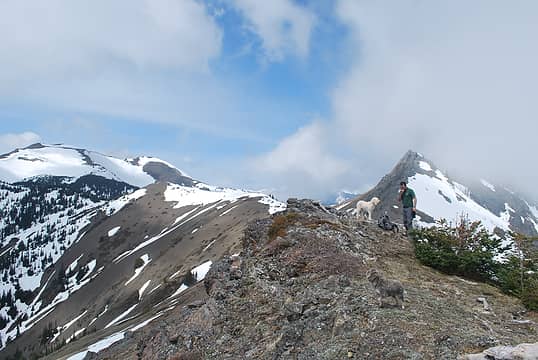
Amazingly, we were able to reach the summit without dealing with any snow beyond a tiny patch in the woods  I was too busy trying to catch my breath to take many photos, but I did manage this decent one.
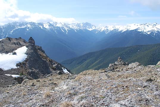 Looking up the Dungeness River valley from Tyler Peak in the NE Olympics
|
| Back to top |
  
|
|
bobbi
stillaGUAMish

Joined: 13 Jul 2006
Posts: 8012 | TRs | Pics
Location: olympics! |
|
bobbi
stillaGUAMish
|
 Sun May 20, 2012 9:20 pm |
|
|
bobbi ૐ
"Today is your day! Your mountain is waiting. So
get on your way!" - Oh, the Places Youll Go! By Dr. Seuss
|
| Back to top |
|
|
RodF
Member

Joined: 01 Sep 2007
Posts: 2593 | TRs | Pics
Location: Sequim WA |
|
RodF
Member
|
Sun May 20, 2012 11:56 pm |
|
|
| Quote: | | A couple miles before the Upper Dungeness River Trailhead, you'll come across a junction with a brown sign indicating "Tubal Cain 6 miles, Dungeness Area Trails 2 miles". Take the unmarked road to the right and follow this rocky road till its end (elev 3200). |
It now has a sign...
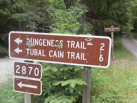 note new sign in background 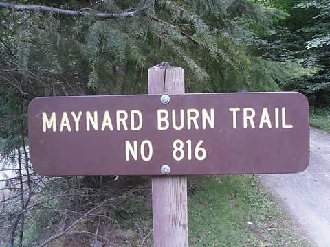 Maynard Burn trailhead sign on FS2870 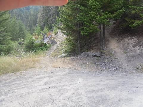 unsigned Maynard Burn trailhead (left) and Tyler Peak trailhead (right) at end of FS2870-270
"of all the paths you take in life, make sure a few of them are dirt" - John Muir
"the wild is not the opposite of cultivated. It is the opposite of the captivated - Vandana Shiva
"of all the paths you take in life, make sure a few of them are dirt" - John Muir
"the wild is not the opposite of cultivated. It is the opposite of the captivated - Vandana Shiva
|
| Back to top |
|
|
Benzarino
Member
Joined: 26 Feb 2009
Posts: 309 | TRs | Pics
Location: Bellingham |
As far as I remember, there weren't any downed trees. The lower reaches were in pretty remarkable shape for an "unofficial trail".
Thanks for putting those road sign photos up, I'm sure they'll be a lot more helpful than my description.
|
| Back to top |
|
|
Phil
Member

Joined: 02 Jul 2003
Posts: 2025 | TRs | Pics
Location: Shoreline, WA |
|
Phil
Member
|
Mon May 21, 2012 7:41 am |
|
|
Wow.... snow free already? Any pics of the ridges to baldy?
|
| Back to top |
|
|
Benzarino
Member
Joined: 26 Feb 2009
Posts: 309 | TRs | Pics
Location: Bellingham |
Yeah, surprisingly it was snow free to the summit. With the manzanitas and rocky "soil", at times it felt more like Central WA than the Olympics!
Is the trip up Baldy much tougher than the route up Tyler?
Unfortunately this is the best pic I got
 Looking towards Baldy from somewhere between Peak B and Tyler Peak
|
| Back to top |
|
|
Phil
Member
Joined: 02 Jul 2003
Posts: 2025 | TRs | Pics
Location: Shoreline, WA |
|
Phil
Member
|
Mon May 21, 2012 10:16 am |
|
|
Thanks for the pic.... it does show that snow appears to increase as you get over to the ridges near Baldy and on Baldy itself. Here's a shot not too far from where you took yours, only it was taken last July when we were up there:
I took the Baldy route a few years ago and don't recall that it was any easier. Of course it does get you further along the Gray Wolf Ridge but I think the stretch from Tyler over to Baldy is scenic enough to get my vote for the best place to start if you are doing a full run of the ridge.
|
| Back to top |
|
|
IanB
Vegetable Belayer

Joined: 21 Jul 2010
Posts: 1062 | TRs | Pics
Location: gone whuljin' |
|
IanB
Vegetable Belayer
|
Mon May 21, 2012 2:13 pm |
|
|
The Maynard Burn trail is both much steeper and much less scenic than the Tyler trail. Even if the destination is no farther along the ridge than Baldy, I'd still recommend using the Tyler trail on the way up and maybe descending via the Maynard trail as the straighter shot back to the car.
on your early season reconnaissance!
"Forget gaining a little knowledge about a lot and strive to learn a lot about a little." - Harvey Manning
"Forget gaining a little knowledge about a lot and strive to learn a lot about a little." - Harvey Manning
|
| Back to top |
|
|
Tag Man
side hiller

Joined: 20 May 2008
Posts: 602 | TRs | Pics
Location: Where the roots all twist... |
|
Tag Man
side hiller
|
Mon May 21, 2012 2:23 pm |
|
|
So is it safe to assume the "unmarked road to the right" was in decent shape? I was worried it wouldn't get fixed last year. It was in pretty bad shape.
|
| Back to top |
|
|
RodF
Member
Joined: 01 Sep 2007
Posts: 2593 | TRs | Pics
Location: Sequim WA |
|
RodF
Member
|
Mon May 21, 2012 2:46 pm |
|
|
I agree with Phil and Ian.
Both are steep climbs, but the Tyler way trail route was laid out ~30 yrs ago by local hunters / horse packers as an alternative to Maynard Burn, which is so steep that it's unsafe for pack stock. So Tyler has more switchbacks and is not quite as steep (except where hikers have shortcut the switchbacks).
The Tyler Peak way trail also has several water sources along it, which the Maynard Burn trail lacks. So I prefer to go up Tyler, and down Maynard Burn. The meadows on the south face of Tyler put on a spectacular show of wildflowers in May and June. This makes a nice loop hike for climbing Baldy.
TagMan - yes, the FS2870-270 spur road to the Maynard Burn / Tyler Peak way trailheads was repaired last November. Longer term, its fate is uncertain (USFS proposes decommissioning it).
"of all the paths you take in life, make sure a few of them are dirt" - John Muir
"the wild is not the opposite of cultivated. It is the opposite of the captivated - Vandana Shiva
"of all the paths you take in life, make sure a few of them are dirt" - John Muir
"the wild is not the opposite of cultivated. It is the opposite of the captivated - Vandana Shiva
|
| Back to top |
|
|
Benzarino
Member
Joined: 26 Feb 2009
Posts: 309 | TRs | Pics
Location: Bellingham |
| Tag Man wrote: | | So is it safe to assume the "unmarked road to the right" was in decent shape? I was worried it wouldn't get fixed last year. It was in pretty bad shape. |
Well it's hard to say cause a "good" road to some people might be awful to others, but I thought the road bed was in good condition. There were a lot of large, angular rocks which made me a little concerned about a flat, but I just took it slow.
|
| Back to top |
|
|
Tag Man
side hiller
Joined: 20 May 2008
Posts: 602 | TRs | Pics
Location: Where the roots all twist... |
|
Tag Man
side hiller
|
Mon May 21, 2012 3:30 pm |
|
|
| BellinghamBen wrote: | | There were a lot of large, angular rocks which made me a little concerned about a flat, but I just took it slow. |
Last year, the road was nearly washed away in one area. Its always been on the rough side. Glad to hear they fixed it like they said they would.
|
| Back to top |
|
|
tigermn
Member

Joined: 10 Jul 2007
Posts: 9242 | TRs | Pics
Location: There... |
|
tigermn
Member
|
Mon May 21, 2012 6:30 pm |
|
|
Anyone have a track or approximation of the route taken?
|
| Back to top |
|
|
Tag Man
side hiller
Joined: 20 May 2008
Posts: 602 | TRs | Pics
Location: Where the roots all twist... |
|
Tag Man
side hiller
|
Tue May 22, 2012 8:51 am |
|
|
Here is a map I made a couple years ago when I went up to Baldy. To get to Tyler, go east when you hit the ridgeline. Last year we did a trip and hit Tyler and Baldy in the same day. Some folks go up and do Baldy and then take the ridge out to Graywolf. The north-eastern trail is Tyler Peak trail. The south-western trail coming down from Baldy is the Maynard Burn Trail.
For anyone reading this that wants to try to do the loop, make sure you know exactly where to catch up with the trails since they peter out near the top and could be hard to find if you don't know where they are or aren't paying attention.
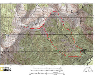 Baldy Loop Map
|
| Back to top |
|
|
trestle
Member
Joined: 17 Aug 2008
Posts: 2093 | TRs | Pics
Location: the Oly Pen |
|
trestle
Member
|
Tue May 22, 2012 9:54 am |
|
|
Was the rock cairn at the top overwhelmed with flies and gnats? That can be one nasty summit....
great trip though, way to get after it early.
"Life favors the prepared." - Edna Mode
"Life favors the prepared." - Edna Mode
|
| Back to top |
|
|
|
|


 steep is all i can think of at the moment
  thanks!


