| Previous :: Next Topic |
| Author |
Message |
daffish
Member


Joined: 16 Sep 2009
Posts: 282 | TRs | Pics
Location: Dreamtime |
|
daffish
Member
|
 Thu Jun 14, 2012 6:36 pm |
|
|
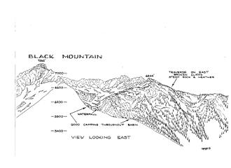 Black Mtn (east) 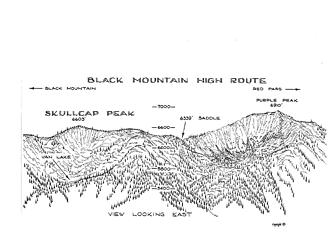 Scullcap Peak 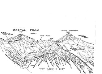 Portal Peak 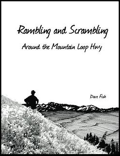 Book Cover
"Be moderate in everything, including moderation" Horace Porter
"Be moderate in everything, including moderation" Horace Porter
|
| Back to top |
  
|
|
dicey
custom title

Joined: 11 May 2004
Posts: 2870 | TRs | Pics
Location: giving cornices a wider berth |
|
dicey
custom title
|
Thu Jun 14, 2012 7:00 pm |
|
|
I know a couple of people who have this book and I'm tempted to buy my own copy. A great collection of Mountain Loop scrambles, and really nice drawings 
|
| Back to top |
|
|
Magellan
Brutally Handsome

Joined: 26 Jul 2006
Posts: 13116 | TRs | Pics
Location: Inexorable descent |
|
Magellan
Brutally Handsome
|
Thu Jun 14, 2012 7:17 pm |
|
|
I am all over this! Thanks for doing it!
|
| Back to top |
|
|
b00
Member

Joined: 29 Sep 2003
Posts: 1144 | TRs | Pics
|
|
b00
Member
|
Thu Jun 14, 2012 7:34 pm |
|
|
|
| Back to top |
|
|
RichP
Member

Joined: 13 Jul 2006
Posts: 5633 | TRs | Pics
Location: here |
|
RichP
Member
|
Thu Jun 14, 2012 7:44 pm |
|
|
|
| Back to top |
|
|
puzzlr
Mid Fork Rocks

Joined: 13 Feb 2007
Posts: 7220 | TRs | Pics
Location: Stuck in the middle |
|
puzzlr
Mid Fork Rocks
|
Thu Jun 14, 2012 8:16 pm |
|
|
I hope you get a large % of the price Amazon charges. I just purchased one. You do great work -- how about traveling south and doing some sketches in the Middle Fork? Garfield is an amazing mountain - different from every direction.
|
| Back to top |
|
|
Schryder
Member

Joined: 12 Aug 2010
Posts: 125 | TRs | Pics
Location: olympia |
|
Schryder
Member
|
Thu Jun 14, 2012 9:25 pm |
|
|
Ordered one, looks very cool! Congrats.
|
| Back to top |
|
|
zephyr
aka friendly hiker

Joined: 21 Jun 2009
Posts: 3370 | TRs | Pics
Location: West Seattle |
|
zephyr
aka friendly hiker
|
Thu Jun 14, 2012 10:18 pm |
|
|
Awesome, daffish. Your sketch of The Eaglet convinced me to go up there this spring. Great work! ~z
|
| Back to top |
|
|
Riverside Laker
Member

Joined: 12 Jan 2004
Posts: 2818 | TRs | Pics
|
This is a fabulous book. Thumbs up for making this available!
|
| Back to top |
|
|
ree
Member

Joined: 29 Jun 2004
Posts: 4399 | TRs | Pics
|
|
ree
Member
|
Fri Jun 15, 2012 10:10 am |
|
|
We are getting some extra copies to give to friends. Makes a great gift for a hiker or lover of the Cascades.
There are some ideas for some great hiking destinations too. Dave is very knowledgeable about the mountain loop area.
Well done, Dave.
|
| Back to top |
|
|
aywolfpac
Member

Joined: 27 Jan 2008
Posts: 1286 | TRs | Pics
Location: Burlington, WA |
Very cool. I have seen a few of these drawing on trip reports and the like and never realized they were yours.
|
| Back to top |
|
|
contour5
Member

Joined: 16 Jul 2003
Posts: 2963 | TRs | Pics
|
|
contour5
Member
|
Fri Jun 15, 2012 6:52 pm |
|
|
These are great! I mean really, really well done.
I hope you keep doing these, and add more sections over time.
A tiny, whiney request for future editions: Color coded trails, bootpaths, THs, etc, for us old geezers with fading eyesight. Black on black confuses my aging optical input sensors.
Beautiful Work!
|
| Back to top |
|
|
daffish
Member
Joined: 16 Sep 2009
Posts: 282 | TRs | Pics
Location: Dreamtime |
|
daffish
Member
|
Fri Jun 15, 2012 8:02 pm |
|
|
Thanks for all the kind words.
I think I started doing these sketches in the mid 1990s. The concept started in part to make them easily reproducible on a copy machine. The original sketches are inked on an 11 x 17 sheet of paper and reduced down to 8.5 x 11. My first attempt at sharing was a spiral bound collection that I had printed in (I think) 2002 and distributed out to friends. I think that is what Dicey is referring to in her post. But that collection only has about half as many sketches as this new edition. I still kept doing new sketches with a somewhat dim idea of making a formal book. Last year, when I read fellow NWHiker rhughes blog on self publishing (here), I knew the time had come to get my act together (Thanks Roy). The fact that I stayed with my original format has enabled me to have the book printed entirely in black and white and thusly has kept the price down significantly. If there was any color whatsoever in the book, the price would jump to about twice as much. And of course there has been a slow evolution in the sketches themselves. Some are better than others from both an artistic viewpoint and an informational standard.
Hope you all enjoy the book and can derive as much pleasure and adventure scrambling the mountains as I have.
"Be moderate in everything, including moderation" Horace Porter
 Joey Joey
"Be moderate in everything, including moderation" Horace Porter
Joey
|
| Back to top |
|
|
popzeus
Member

Joined: 18 Apr 2011
Posts: 136 | TRs | Pics
Location: Kenmore, WA |
|
popzeus
Member
|
Fri Jun 15, 2012 8:57 pm |
|
|
These are absolutely beautiful. I just ordered my copy, can't wait till it arrives.
|
| Back to top |
|
|
rhughes
Painter

Joined: 12 Nov 2003
Posts: 217 | TRs | Pics
Location: Snohomish |
|
rhughes
Painter
|
Sat Jun 16, 2012 10:04 am |
|
|
Congratulations Dave on publishing your book. I've just ordered my copy through the NWHikers Amazon link.
It's always great to see a local writer/artist get his or her work into print. And it's a great thrill for the author to finally do it. I would encourage those of you who "have a book in you" to consider writing and publishing it. It is a bit of a rocky road but the process has improved tremendously over the past few years. Don't think that you'll make a ton of money from it, because you most likely won't, but it is a great experience.
What Dave said about printing in color is true. My book, North Cascades Beautiful, had to be priced fairly high for me to even make a few bucks per book. To add color to his book Dave might have to price it out of the market to break even. I've been looking into creating an ebook in color which could be priced much lower but that medium is fraught with problems at the moment as well. It is not a simple conversion for a book of text and images to be converted to a Kindle-type format. Besides, I see Dave's book as much a work of art as it is a hiker's reference and black and white works just fine for that, I believe.
The beauty of a book like Dave's is not just that you can view the trails and elevation for a particular area but that you can look at these map sketches and re-live the times that you've trekked over these areas. His is a book that just keeps on giving. I can't wait for my copy to arrive.
rhughes Painter
Author of North Cascades Beautiful: An Artist's View
Author of 100 Beautiful Views of Glacier National Park
RoyEHughes.com
rhughes Painter
Author of North Cascades Beautiful: An Artist's View
Author of 100 Beautiful Views of Glacier National Park
RoyEHughes.com
|
| Back to top |
|
|
|
|


