| Previous :: Next Topic |
| Author |
Message |
caseynw
Member


Joined: 27 Jun 2008
Posts: 91 | TRs | Pics
|
|
caseynw
Member
|
 Tue Jul 03, 2012 12:42 am |
|
|
Whiskey Dick Mountain, Schaake Wildlife Area, June 29-July 1
After some exploring 2 weeks prior off Vantage Highway, and waiting for a good window on weather, we decided to head out on Friday (June 29) to make a weekend camp out of it. The weather reports varied wildly between sun, rain, thunderstorms, and high winds. It also did not help that the particular area is not really forecasted for, but I suspect that some of the BPA wind generation forecasts for the Wild Horse facility might be the best resource in calculating the unique winds in the area.
We brought our baby son and two daughters, as well as another family with us. They are used to camping with zero facilities, so it wasn't an entirely big deal. We had a 4WD SUV with us, as well as a RWD truck. Both had reasonable amounts of clearance, or so i thought.
Not knowing the area, we decided to start at a point off the Vantage Highway around Schnebly. There is a map here posted with Green Dot roads, where we took pictures to get an idea of what we could drive on. One of the cars had the entire map system loaded in its navigation system, which helped us mostly stay on track and avoid violating the nonexistent WAC 232.12.187 (there's only a 181 and 189 in law).
We took Pump House Road, which was nothing threatening. Within the first half mile, we passed by a campsite that we eyeballed earlier, only to see someone just pulling up to camp. That was okay, surely there would be other sites..right? These were the only other humans we encountered during our entire trip.
It was a sunday drive up until we hit a series of very steep switchbacks with deep ruts and washed out areas that lead into the valley. It was obvious that water runoff floods down this road as well and easily cuts into the soft sandy soil, making road navigation slow and difficult. There was incentive to stay on the road, however, as steep cliffs would greet any false moves. We later realized that while the SUV might do fine, the truck would probably never make it back up that hill. The dirt was very loose. There was potential of other ways out of the area, so we pressed forward.
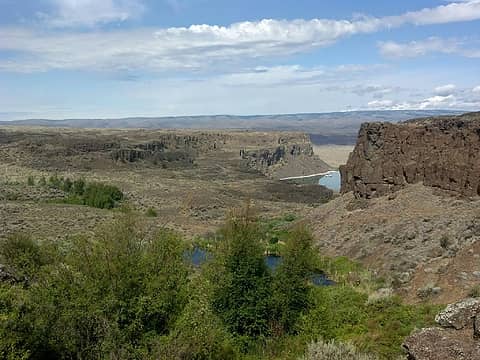
The entire area is very dry and deserty. The hills are covered were covered with sage, sparsely placed bunches of desert flora, and an occasional cactus! Wow! Wild cactus in Washington, i never would have thought to see something like this.The other family we were traveling with were from New Mexico, and kept commenting on how much they felt like home. In each valley, a narrow band of greenery was present, and a dry creek bed. It was obvious there was water around, but it was not at ground level.
As we drove through the lush Rocky Coulee, the road was decent. We passed an old well and took a look at it. It was a short reprieve until we were faced with having to make a similar uphill trek! The RWD truck lost traction going up one of the steeper sections of the hill. He could not move any further, and had to back down to get some more speed. After another attempt, he made it. The SUV made it in the first try, although, there was a lot of spinning, slipping and all wheel gripping action taking place. And some very high rocks made for a lot of gut wrenching bangs and clunks.
(A tame piece of road)
We passed the green Lone Star Spring and headed up another section of hill. After passing a bend, we started facing a lot of very large rocks in the roadway. They were embedded deep in the dirt and we started seeing a serious amount of scraping in the undercarriage area as we progressed. The truck could not make it up this section of hill, and had to take a few runs at it. The SUV almost did not make it up this next section of hill. One cracked oil pan, bent control arm, or blow out could really make this an expensive trip.
The trip was slow and challenging. Drive a little bit, take it nice and slow over large rocks, see a hairy spot, come up with a plan of action, move forward. Some people would really cringe at this type of thing, but we really enjoyed the situation. It is hard to find a challenging road to navigate, with something unexpected around every corner.
After an hour or so, we crested the second large hill, Whiskey Dick Ridge Road. it was getting dark, and we were not seeing any established camp spots. Sure, we could just throw our tent on some rocks, but I much rather like to camp on established areas. Pressing forward, we went down the hill, past Cayuse Road, and ended up at a fork in the road (Whiskey Dick Creek Road) with a clearing butted up next to it. There was a fire ring, so we considered it an established camp site, and set up camp.
Directly next to us was Schaake Wildlife Area. It was like an oasis wedged between two dry desert hills. fields of tall green grass with trees dotting the area. A deep dry creek bed ran along its side. One interesting thing about the entire area is that due to the proximity of I-90 and the Gorge, the location has reasonably useful cell coverage on both Verizon and AT&T.
We woke up to cheerfully chirping birds and light breezes blowing over grass. It was a gorgeous day, so we decided to set out in our one good vehicle and see where Whiskey Dick Creek Road would take us. Coming around the corner of the road towards Hartman Creek Road, we hit a quick and abrupt end to our trip. Several boulders in the dirt at the crest of a bump in the road made it completely impassible. Well, I guess i *could* have tried, but the damage could have been quite bad. We turned around and headed the other direction.
We drove past our campsite and further on Whiskey Dick Creek Road towards the other direction. The canyon walls narrowed, and some of the steep rock cliffs were in reach from the road. We noticed a small cave that was perhaps 50-100 feet away from the road, so we decided to take the kids with us an ascend a small gully leading up to it. We took a peak inside and noticed quite a bit of guano, but it could have easily have been rat droppings. Deeper inside, we saw a nesting area, and decided to retreat back. We climbed up above the cave area to the west of the entrance, and noticed that there were quite a few other enclaves in the area. There are certainly no shortage of places to explore around here.
Treking further west, we encountered some more trouble along the road where going forward was no longer an option, so we drove back to camp.
We decided that since it was not even noon to do some reconnaissance work along Cayuse Road, which was a little further up the hill from camp. The road was rough going, as usual, and along one point I had to straddle the vehicle on two high puts of a rut that had to have been several feet deep. I had one of the party members guide me on the rut, as he shot low angle video that could be worthy of a SUV commercial.
Cayuse Road drives through a lust wooded area with a spring, which was filled to the brim with water. There was a nearby field, some in the open, and some shaded, which looked like a good place to camp. There are also some old remnants of some sort of structure.
We took a right at the Y (which according to the map took us back to the state park), and ascended into some reasonable switch backs. There were areas of softer sand-like soil, remnants of old fencing, and other interesting views along the way. The road was rough, and the rocks were considerably sharp. But the grade was not unreasonable.
Crossing into the State Park boundary as per the sign, we knew we had it made, or so we thought. The road descended from hill, we saw pavement in the distance, around the corner, and BAM. Locked gate.
You gotta be kidding me? I am on the WRONG side of a combo locked gate, and it is the weekend. Just our luck.
I went on the other side of the sign, and it prominently displayed "Access By Permit Only". I thought back to the park boundary sign, which said nothing about this being a restricted area, and wondered why on earth anyone would need a permit to drive on this road one direction but not the other. People drove by with their mouths open as they saw us standing around wondering what to do next. We called the phone number on the sign, only for it to go directly to voicemail.
We noticed a security weakness in the structure, and we came to realization that others have been in this predicament before and took matters in their own hand, and then reassembled the gate to its original state. But before any felonious "modifications" to the structure took place, the cell phone rang. It was the lady from the state park!
After some sweet talking (and recording of all of his personal information), one of our party members was able to finagle the combination out of her. We may have inadvertently applied for a permit over the phone, I do not know. We kindly explained about how horrible access was from Vantage and asked for permission to return through this same gate, and she said yes. Perfect!
Since we were hungry and Vantage was a mile away, we stopped in for a bite to eat at Blusteries, visited the beach at the state park across I90, and headed back. As we crossed out of the state park boundary, and drove along, my "Low Tire Pressure" alarm started sounding. I indicated that one of my tires recently developed a slow leak, which i had to top off the pressure a week ago, and that i'd probably have to have it patched when we returned. Then that ominous sound developed.
Two people went out to inspect the damage. It turned out the slow leak tire was fine and of good pressure, but that didn't matter much, a rear tire had a 4 inch gash the side wall and was completely flat.
I had to drive the car down to a flat area and change the tire. While the spare was "full sized", it was half width and had a horrible tread. Oh great. So now I have the SUV, which had clearance problems already, loaded with 4 adults and 4 kids, riding on a time bomb over sharp lava rocks. Since had 4 miles to go to the camp site, and turning back was not a realistic option, we kept going. The vehicle slid around, drug its tail end a little, but we made it back to camp. No damage on the spare. We were looking good.
At camp, we noticed a little sandwich baggie from Ranger Citation on the other vehicle with a Discovery Pass ticket inside! These funds will surely go directly to maintaining the worthless road system out here, closure of perfectly good roads to motor vehicles by omitting Green Dot signs, and needlessly gating off people from legally accessing Discover Pass areas from state parks.
While watching the weather radar, we noticed some nasty storm cells developing. It was spotty but there was a chance we were going to get hit. It went from sunny to heavy downpour and thunder, and back to sunny again. We were treated to a rainbow. Just after we dried off a bit, we were due for storm -- this time a direct hit.
While no ground strikes, there was no shortage of lightning bolts. We put an HD camera out to catch the front of the storm roll through, and caught some awesome video. (waiting for the pics/video)
After some downpour, the storm abruptly left, the last bits of sun came out, and the birds started to chirp again. There was a double rainbow over one of the hills.
That night, the wind began to pick up a little bit. We were hit by gusts here and there, but nothing that would knock over a properly staked tent. It couldn't have been more than 15 mph during a peak gust.
Then, around midnight, we started hearing a faint very low bass, almost rhythmic. We exited the tent to take a look at what it could be, as surely there was someone thumping music and driving near by. But there was nothing. No light. No car sound. No indication of human activity for quite some distance. We could see a good mile or so in any direction.
Laying down again, we heard the faint bass-like sound, but the longer we listened to it, the more it sounded like the muffled bass of a talk show or spoken word on an AM radio station
much like from outside of a car from a distance. It seemed to be loudest while laying down, and we could not hear it when wind was calm. It went on for HOURS. This continued up until about 5 am, when the sun started to rise. Then it was completely gone.
I am curious what this was attributed to. Could it have been the wind turbines in the distance? Some sort of low rumble of wind blowing through the sage? Distant partying carried in the wind? It probably wasn't the Gorge, as the wind was blowing from the west the entire night. I have never camped out here before, so i am curious if anyone else has heard something like this. Never heard anything like this before in all of our adventures.
The next morning, we packed up and departed camp. Left no trace. And headed out towards the gate. While it was nerve racking, the spare somehow made it out alive, and got to experience actual pavement. I am happy to avoid yet another "Off Road Extraction" in this vehicle.
|
| Back to top |
  
|
|
Laural
Member

Joined: 31 Aug 2007
Posts: 156 | TRs | Pics
|
|
Laural
Member
|
Tue Jul 03, 2012 2:16 pm |
|
|
Any chance you can edit the photos to be smaller size?
Try Quincy Lakes next time, it's a lot easier on the car 
|
| Back to top |
|
|
caseynw
Member
Joined: 27 Jun 2008
Posts: 91 | TRs | Pics
|
|
caseynw
Member
|
Tue Jul 03, 2012 3:55 pm |
|
|
Sorry, big monitor here  I edited them down to a reasonable size.
Quincy Lakes doesn't look too bad. Can you camp there? Does it get a lot of people? I edited them down to a reasonable size.
Quincy Lakes doesn't look too bad. Can you camp there? Does it get a lot of people?
|
| Back to top |
|
|
Laural
Member
Joined: 31 Aug 2007
Posts: 156 | TRs | Pics
|
|
Laural
Member
|
Tue Jul 03, 2012 5:45 pm |
|
|
Yes and not really. There's at least 10 places you can camp.
 view from near our campsite
|
| Back to top |
|
|
|
|
You cannot post new topics in this forum
You cannot reply to topics in this forum
You cannot edit your posts in this forum
You cannot delete your posts in this forum
You cannot vote in polls in this forum
|
Disclosure: As an Amazon Associate NWHikers.net earns from qualifying purchases when you use our link(s). |


