| Previous :: Next Topic |
| Author |
Message |
williswall
poser


Joined: 30 Sep 2007
Posts: 1968 | TRs | Pics
Location: Redmond |
Escaping the thunderstorms in the Seattle area, I headed up to MRNP to take advantage of nice weather (at least in the mountains) and finish up filming the West Side Road on my mountain bike. This was a trip down memory lane for me as I recall driving to the North Puyallup River camp as late as 1986 for a day hike. Now the park service only maintains the road to Klapatche Point and has designated the rest of the old road as the North Puyallup trail. It's a 9 mile ride from parking on the remainder of the road, which is incidentally in nice shape and currently used by the park service vehicles. Why this road has not been reopened for vehicular traffic for the general public remains a mystery. The only problem area for vehicles might be crossing Fish creek, but even this is totally doable in anything but a lowrider. Meanwhile, the west side of the park remains the least accessible in terms of hiking.
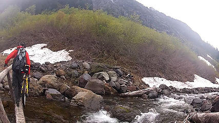 WSR crossing the creek 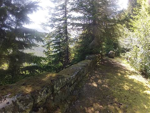 NP Trail2 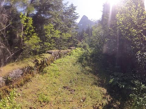 NP Trail3 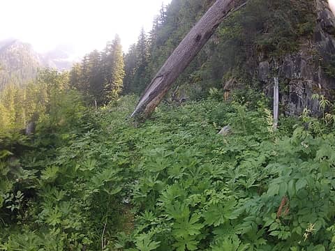 NP Trail4 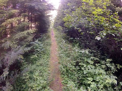 NP Trail5 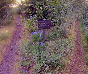 NP Trail6 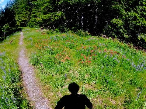 NP Trail flowers 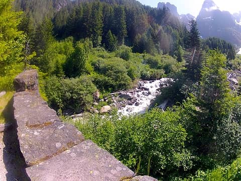 NP river 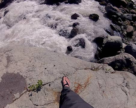 NP river and sandals 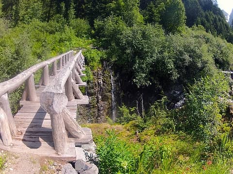 NP river bridge 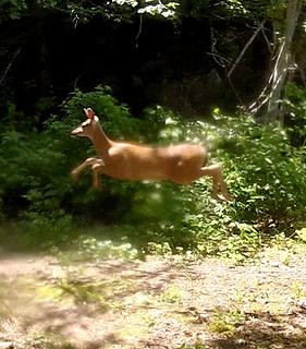 NP Trail passing deer 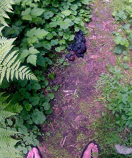 NP Trail bear scat 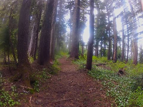 St Andrews Trail 5000'  St Andrews Patrol Cabin2 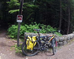 West Side road transportation
|
| Back to top |
  
|
|
ragman and rodman
Member

Joined: 28 Apr 2005
Posts: 1219 | TRs | Pics
Location: http://rgervin.com/ |
A bike definitely works well for hikes on the west side of Rainier.
In 2010 BarbE, rodman and I were able to use our bikes to advantage in making a day trip out of visiting Klapatche Park, St. Andrews Lake and the summit of Tokaloo Rock.
|
| Back to top |
|
|
Mikey
Member

Joined: 04 Sep 2003
Posts: 737 | TRs | Pics
Location: SW Washington |
|
Mikey
Member
|
 Sun Jul 15, 2012 2:07 pm |
|
|
WillisWall wrote: "Why this road has not been reopened for vehicular traffic for the general public remains a mystery."
In my opinion the mystery is related to the Mt Rainier Nat. Park management long term policy of reducing access by the public. Remember, Mt Rainier Nat Park proposed closing the West Side Road and closing the road to Sunrise back in the 1980's. Larry Penberthy filed a lawsuit in Federal Court challenging the reduction in access. I do not know the details but we were climbing Mt Rainier in 1986 when a helicopter came into Camp Schurman with a Mt Rainier National Park person (Asst Superintendent maybe) and a Federal Legal person and they were there to look at the Camp Schurman climbers hut which was built to be used by climbers but the National Park Service was closing it for climber use so that the Climbers Hut could be dedicated for use only by the National Park Service (ie the Climbing Ranger).
So I suggest the mystery of why the West Side Road is not open to the public is because the Mt Rainier National Park management does not want the public driving into that area and probably still does not want the public driving up to Sunrise (but I doubt if they will ever get away of closing the road to Sunrise). There is an excuse that the West Side road gets washed out periodically (which it does but it is repairable), but if the West Side Road is OK for the Mt Rainier National Park Service vehicles and for the organizations and people who have Mt Rainier National Park permission (ie Mt Rainier National Park Service "favorites), then it is most likely OK for the general public (I have heard from folks folks such as WTA work parties and some Friends of Mt Rainier National Park group that they have been able to use the West Side Road).
I too remember when we could drive north on the West Side Road and hike the trail up to Klapatch Park, St Andrews Rock, etc. and I think it is a bummer that this road is not open to the public.
By the way, I do not know what Congressional District Mt Rainier National Park is in but I am guessing that the House of Representatives member pays little attention to what goes on at Mt Rainier National Park. And I have heard very little from our two Senators about Mt Rainier National Park.
In summary, public access to Mt Rainier National Park is on the decline most recently with the reduction at the Carbon River area.
|
| Back to top |
|
|
williswall
poser
Joined: 30 Sep 2007
Posts: 1968 | TRs | Pics
Location: Redmond |
I have emailed the park superintendent asking specific questions regarding the road. Pending responses, I have other ideas for bringing this matter further forward. I do enjoy the solitude offered on the west side but this area should be open to the public to help mitigate usage concentrations.
|
| Back to top |
|
|
Hikingqueen
Member

Joined: 12 Nov 2007
Posts: 2946 | TRs | Pics
|
|
| Back to top |
|
|
Barefoot Jake
Professional Bum

Joined: 05 Sep 2010
Posts: 564 | TRs | Pics
Location: Olympic Peninsula |
|
| Back to top |
|
|
Grey Heckel
Member
Joined: 09 Feb 2012
Posts: 38 | TRs | Pics
Location: Seattle,WA |
Simply put - the Park Service is a bunch of .............. sses, who want the area all to themselves. No consideration whatsoever to elderly citizens who would still like to walk to earlier destinations in their life, but are not physically able to put out the sustained energy needed (because of road closures) to negotiate the additional mileage required nowadays, even though those citizens are in even greater numbers now and would like to improve on their physical condition through moderate hiking; I doubt the originaters of the National Park System had in mind the recent park mangement of exclusion of the elderly (shame on Yopu -Park Service). The first word was : arrogant!
|
| Back to top |
|
|
TokyoTessie
Member

Joined: 28 Jan 2005
Posts: 480 | TRs | Pics
Location: Back in the shadow of Tahoma again! |
Thanks for the trip down memory lane, WW! I was up there twice for Wonderland Trail service trips - once with the Sierra Club, where NPS drove us and our gear to Klapatche Point and we walked in to the NP bridge, where we spent the week camped out along the wall at the base of the bridge, overlooking that beautiful valley, which reminds me of pictures of Eden. Every morning, we would watch the sun come up behind those huge rock formations, and more than one of us would start singing "Here Comes the Sun" as it would warm up enough to strip off the layers of fleece that were necessary, even in the summer. The other time, it was with the WTA, when NPS again drove us to Klapatche point, where we spent the week camped out, and walking in and out to NP daily to work on the Wonderland. Lots of salmonberry and devils club to tear up your legs, even through long pants.
I've always wanted to go back, but find the hike/ride back up a little daunting, since I can cover only a fraction of what you do in a day. Well, maybe one of these days...
|
| Back to top |
|
|
Karen
Member

Joined: 22 Dec 2001
Posts: 2866 | TRs | Pics
|
|
Karen
Member
|
Thu Jul 19, 2012 7:35 am |
|
|
We don't have mountain bikes but we recently hiked the road up to Denman Falls. Lots of historical points of interest along the way and more scenic than you might expect. We're not young but it only took us 7.5 hours round trip for the hike and that included time for taking photos.
Sure would like to get to Klapache Point though ...
Karen
stay together, learn the flowers, go light - from Turtle Island, Gary Snyder
stay together, learn the flowers, go light - from Turtle Island, Gary Snyder
|
| Back to top |
|
|
silence
Member

Joined: 25 Apr 2005
Posts: 4420 | TRs | Pics
|
|
silence
Member
|
Thu Jul 19, 2012 8:19 am |
|
|
A few years ago in early Aug we did a trip along the Westside ... up from Denman Falls to Klapatche, and then on to Golden Lakes..
We returned in one day via the Westside road coming out on the N Puyallup trail ... thankfully the trail had just been brushed out by the volunteer trail folks cause otherwise it would have been a major shwack
Anyhow the road walk isn't so bad .. in fact it's quite scenic .. and ez walking
And, I have to agree with Tokyo .. the North Puyallup valley is just gorgeous ... and other worldly .. it was a sight to behold when we dropped down from Klapatche and laid eyes on it for the first time
This might answer some questions about Park management, dated 2002:
The Record of Decision for the Final Environmental Impact Statement and General Management Plan (FEIS/GMP) for Mount Rainier National Park has been approved. Under the new General Management Plan, park managers will improve stewardship of park resources while continuing to provide a range of high-quality visitor experiences. Most of the park (97%) is designated wilderness and will continue to be managed according to the provisions of the Wilderness Act. Most of the structures within the park are listed on the National Register of Historic Places and will be preserved for public use and enjoyment in their historical character. The primary goals of the new General Management Plan are to better manage peak-period visitation so that it does not adversely affect park resources and visitor experiences.
Key elements of the plan include the following: Establish a visitor carrying capacity framework and use it to ensure the preservation of park resources and the quality of the visitor experience. Phase in shuttle services in coordination with elimination of overflow parking to reduce traffic congestion and ensure effective visitor transportation within the park; provide shuttle service to various locations in the park, such as Longmire/Paradise, Westside Road, Sunrise, Mowich Lake, and Carbon River. Provide additional opportunities for visitors to use the park in the summer and winter, including: providing shuttles on the Westside Road, providing new picnic sites, improving interpretive facilities, and establishing or improving snow-parks for winter visitors. Replace the Henry M. Jackson Memorial Visitor Center at Paradise with a smaller, more efficient visitor center and reconfigure the parking area for shuttles. Improve the visitor information program internally and externally; use welcome centers outside the park to provide visitors information for planning their visits to the park and region. To reduce the amount of sediments and pollutants entering Mowich Lake, close the road to vehicles 0.5 mile from the lake and convert it to a trail. After completion of the boundary adjustment and development of the new facilities, close the Carbon River Road to private vehicles when there is a major washout of the road and convert the Ipsut Creek Campground to a walk-in/bike-in camping area. Recommend a boundary adjustment west of the Carbon River Entrance, including about 1,063 acres to provide for a new campground, picnic area, and administrative facilities, and to protect the river corridor. (Congressional action would be required for this action.)
This document and the final General Management Plan and EIS can be downloaded here: http://www.nps.gov/mora/parkmgmt/index.htm
PHOTOS
FILMS
Keep a good head and always carry a light bulb. Bob Dylan
PHOTOS
FILMS
Keep a good head and always carry a light bulb. Bob Dylan
|
| Back to top |
|
|
Slugman
Its a Slugfest!

Joined: 27 Mar 2003
Posts: 16874 | TRs | Pics
|
|
Slugman
Its a Slugfest!
|
Thu Jul 19, 2012 10:41 am |
|
|
If the NP was evil and wanted to keep all people out, why did they work like demons to repair the massive damage caused by flooding a few years back? Wouldn't they have just sat back and said "Don't blame us, blame mother nature"? And then done as little as possible to fix the damage?  And to claim the NP is deliberately harming the elderly is too disgusting of an accusation to refute as forcefully as it deserves in williswall's trip report.
|
| Back to top |
|
|
Laural
Member

Joined: 31 Aug 2007
Posts: 156 | TRs | Pics
|
|
Laural
Member
|
Thu Jul 19, 2012 3:10 pm |
|
|
Yeah, last time I went to Rainier on a weekend, they had shuttles from Paradise and Cougar Rock to Sunrise. If they opened the Westside Road to shuttles only on weekends, that would still be great.
|
| Back to top |
|
|
hermes
Member

Joined: 24 Feb 2005
Posts: 450 | TRs | Pics
|
|
hermes
Member
|
Thu Jul 19, 2012 7:50 pm |
|
|
AFAIK the main reason the Westside Road remains closed is that the washouts that occur are caused by glacial outbursts that come down Tahoma Creek (so much water, ice and junk that it can't quite make the turn at Fish Creek) and unlike washouts caused by wet and/or warm weather are totally unpredicatable and if you take a look up the Tahoma Creek canyon towards the scary bridge you can clearly see that they are quite catastrophic. Think Missula flood on a smaller but similarly devastating scale. The road was originally built when such processes were not well understood (Scrooge can probably fill you in on the details here) but after two successive washouts and with the new understanding of glacial outbursts it was considered too dangerous to reopen the road at the Tahoma/Fish creek junction.
Thank you for the report WW, very informative.
|
| Back to top |
|
|
lopper
off-route

Joined: 22 Jan 2002
Posts: 845 | TRs | Pics
|
|
lopper
off-route
|
Thu Jul 19, 2012 8:36 pm |
|
|
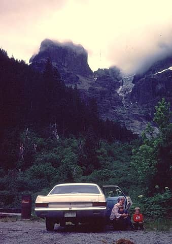
The headwaters of the N Puyallup are certainly impressive.
Once upon a time you could take the family sedan there.
Here is a "memory-lane" photo. July 11, 1981.
 81WestSideTerminus
|
| Back to top |
|
|
Magellan
Brutally Handsome

Joined: 26 Jul 2006
Posts: 13117 | TRs | Pics
Location: Inexorable descent |
|
Magellan
Brutally Handsome
|
Thu Jul 19, 2012 10:48 pm |
|
|
| williswall wrote: | | this area should be open to the public to help mitigate usage concentrations. |
Absolutely! Give people another place to get to easily so it's not so darn crowded elsewhere.
| silence wrote: | | ...provide shuttle service to various locations in the park... |
I would love to be on a crowded bus leaning my stinky hiker body up against some sweet smelling tourist. 
|
| Back to top |
|
|
|
|
You cannot post new topics in this forum
You cannot reply to topics in this forum
You cannot edit your posts in this forum
You cannot delete your posts in this forum
You cannot vote in polls in this forum
|
Disclosure: As an Amazon Associate NWHikers.net earns from qualifying purchases when you use our link(s). |


 I want that road open so badly
  Until then i drag my butt up as far as i can, not as far as you go, man you get in the miles!

