Forum Index > Trip Reports > (Marmot) Fortress Mt. & Massie High Route 08_25-26_2012
 Reply to topic
Previous :: Next Topic
Author Message
Bedivere
Why Do Witches Burn?


Joined: 25 Jul 2008
Posts: 7464 | TRs | Pics
Location: The Hermitage
Bedivere
Why Do Witches Burn?
PostThu Aug 30, 2012 2:46 pm 
When this trip was first planned we'd considered doing Bacon Pk. instead but earlier in the preceding week the weather forecast was calling for strong onshore flow and a little later that week the person who'd originally suggested Bacon dropped out of the trip, so altasnob and I decided we'd go further East and climb Fortress Mt. As it turns out the weather was great that weekend and we probably could have done Bacon with no visibility issues, but Fortress was a fine substitute and it allowed me to bring Jack along. We departed Friday evening after work, drove to Trinity and hiked the first ~2.75 mi. to the Chiwawa R. crossing on the Buck Cr. trail. There were a surprising number of people camped at all the spots here so we ended up just crowding up against the trail. No big deal, we were in our tents around midnight and were on the trail around 7:30 the next morning. Not much to see here anyway. Our plan was to hike the Buck Cr. trail to Pass No Pass, drop our gear, climb Fortress then camp somewhere near the pass or along the first stretch of the Massie High Route. The Buck Cr. trail is in good shape and goes by pretty quickly with views up to Buck Mt. and the other ridgeline promontories near High Pass opening out as you go along.
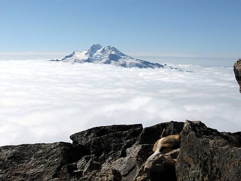
Buck Mt. from Buck Cr. trail.
altasnob pondering the distance remaining as we scope out the surrounding high areas.
As you approach Buck Cr. Pass you get one small view of the top of Glacier Pk. You know it's over there, but it's playing coy along this segment of the trail.
I see you!
I see you!
We were not fooled by the false "trails" leading up off the Buck Cr. trail and took the correct trail up towards Pass No Pass. We stopped for lunch and pondered our options at a nice Marmot rock in the first meadow we came to.
Marmot lunch rock.
Marmot lunch rock.
There were Marmots everywhere. This area has probably the highest concentration of Marmots per square foot of anywhere I've ever been. Big, fat, docile Marmots, all whistling and sunning themselves on rocks until Jack got too close and then they tucked into their burrows. I vote this mountain should be renamed to "Marmot Fortress" mt. as that's literally what it is. After lunch we decided we'd drop our gear at the camp below High Pass, climb the mt. and then if we had enough energy when we got back down we'd go looking for the camp we'd seen in the pictures dicey & fwb posted a couple weeks back. The camp here below High Pass is pretty horsey, but a nice enough camp in the trees. Very dusty at this time though. We dropped off most of our gear, retaining a couple items of clothing and our food and set off to climb the mt. Being full of energy still we decided to take a direct route up a promising looking gulley through the cliff bands rather than trudge all the way up to Pass No Pass where there are some easier ramps.
The gully.
The gully.
This was a nice little scramble with one scary class 5 section:
The lens of my camera sure has a lot of weird distortion at the edges!
The top of the gully opened out onto the broad, steep meadows of the lower slopes of Fortress. About 50-75' above the top of the gully my water bottle slipped out of my pack and went bouncing down. It went right down the gulley, picking up speed and making some spectacular pachinko-ball bounces before disappearing onto the slope below, spinning furiously and spraying water. I'm pretty impressed with how hard a hit a full Aquafina bottle can take. The lower slopes of Fortress are STEEP! Probably the longest slope of heather & vegetation of this steepness I've climbed.
altasnob & Jack reaching the 7200 ft. knob
At about 7200-7400 ft. there is a large knob & flat area where we've seen that people camped before. We had considered camping here ourselves but decided that if we lugged our gear up here we'd stay here for sure rather than attempting to knock part of the high route out. As it turns out, we should've brought our gear up here. Above the flats the heather ends, there are some snow patches still and the steep, rocky sections start.
Looking up to the summit of Fortress Mt.
The easiest route is up the snow but as I'd not brought crampons or an ice axe I elected to stay on the rocks which was easy enough. I went up through the scree finger near the left of the snowpatch in the picture above then followed the left-angling ramp up from there to gain the right-angling shelf above the snow.
Views of Glacier Peak are in your face up here!
altasnob decided to go up the snow as he'd brought his axe and some instep crampons.
It was a hot climb up through the rocks and shelves to the summit as it was now getting on towards late afternoon. Fortunately there was plenty of snow and small runoffs down lower to slake our thirst.
Jack loves mt. climbing
Before long we were at the summit and enjoying the outstanding views. With no peaks of comparable height in the immediate vicinity you can see the landscape all around quite easily. This is one of the most scenic peaks I've been on. There was an old plastic jar, looks like a cookie jar or pretzel jar or something on the summit but someone had placed a nice, shiny new PVC pipe with threaded ends to contain the register. I spent a little bit of time poking through it's contents but it's all little slips of paper rather than a nice, tidy book and many of the entries are all faded out and can't be read. There was a decent breeze and I didn't want any of the papers blowing away so I found the sheet with the most recent entry, added our names to it and spent the rest of the time on the summit enjoying the views.
Faded papers from the summit register.
As penance for dropping my water bottle down the gully I removed the old plastic jar from the summit. If anyone finds a smashed Aquafina bottle on the slope below that gully, please carry it out for me and I"ll gladly compensate you with beer or food or some other item of your desiring.
altasnob on Fortress
Some of the region's big names.
9 labels
Some of the region's big names.
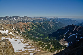
Looking South, down the Chiwawa R. valley.
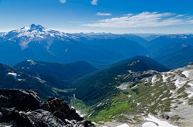
Middle Ridge, Glacier Peak, and the Suiattle valley.
Jack chilling on the summit.
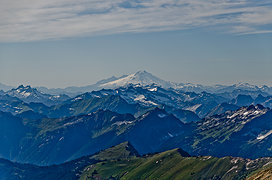
Miner's Ridge to Mt. Baker
The afternoon was getting on and it was time to head back down.
When we got to the snow I decided I would take the easy way down, so did a butt glissade all the way to the bottom. altasnob got video of it.
Glissade tracks.
Glissade tracks.
Glacier Peak in the afternoon.
This area is so darned scenic I couldn't help but take lots of pictures.
altasnob taking a picture with Jack supervising.
Jack keeping the marmots honest.
altasnob descending just above Pass No Pass.
The slopes are so steep just above the pass that it takes just as long going down as up. The vegetation is thick, sometimes slippery, you can't always see where you're putting your foot, and you have to be constantly mindful of marmot holes.
View to the South from Pass No Pass.
Pass No Pass and the evening sun.
It took quite a bit of energy to downclimb those steep slopes and by the time we got back to camp the sun was just about down and we were feeling the day's activities. We decided to stay put and tackle the entire HR tomorrow after a good night's sleep. We ate a bunch of food, drank some tequila and hit the sack. The next morning there were some clouds floating around but nothing threatening as we got underway along the obvious trail to the South.
Near the beginning of the high route.
Glacier Peak, Buck Creek Pass, Marmots.  This is the last good view of Glacier Pk. along the route.
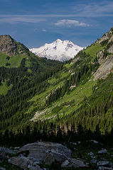
Glacier Peak, Buck Creek Pass, Marmots. This is the last good view of Glacier Pk. along the route.
This is the place to be if you're a Marmot!
The route is very easy to follow from this direction for it's first half. I had a printout of the map daffish posted in this TR: https://www.nwhikers.net/forums/viewtopic.php?p=544745#544745 The ambiguities on the map actually encouraged me to go astray. It's not that there's anything wrong with the route on that map, that's actually the RIGHT way to go, it's that all the notes about the trail being indistinct or possibly an animal path or nonexistent had me thinking that maybe daffish got off route after crossing behind the 6082' knob. Of course, he'd read Routes & Rocks so knew what he was supposed to do, I was just winging it...
Meadow along the route.
View to Trinity.
View to Trinity.
Last pic I took for awhile.  We are off-route here.
Last pic I took for awhile. We are off-route here.
After we passed behind the 6082' knob I saw what looked like a pretty well defined trail just a little bit below. It actually was a well-defined trail, I think every animal in the valley uses it. It kept going down every time an obstacle was encountered and I was thinking that maybe it was logical to go below the area marked "slabby cliffs" on daffish's map as the contour lines are a little further apart there too, indicating a slight bit of a shelf and potentially easier travel. To altasnob's credit, he had the right idea and wanted to stay higher but I argued that it looked like we could easily traverse below the cliffy sections then head straight up to the ridgeline. The problem with this idea is that you lose about 600' that you don't have to and end up far enough down that you can't even see the ridge above and thus can't be sure where you need to start climbing. When we finally determined that we'd gone too far thanks to altasnob getting fed up and pulling out his GPS (I argued that that took all the fun out of things), we started climbing straight up. We ended up intersecting the ridgeline too far to the South. On the map it looks like walking the ridgeline shouldn't be a big deal but of course the 40' contours on the map don't show stuff like this:
We needed to be over on that slope across the way. Fortunately we found a very steep heathery/dirty ramp that descended down a narrow gully to a little basin just South of where we needed to pick up the route again. I'd been rationing the water in my Platypus bag as we hadn't seen any water or snow in quite some time and Jack and I finished the last few drops of it before we descended from the ridge. Fortunately there was a large snow patch in the little basin and I was able to feed Jack enough snow to cool him off and satisfy his thirst.
Mmmm, snowcone!
Mmmm, snowcone!
After a brief rest in this little lonely, cliff ringed basin (we found an old Oly can here, so someone camped here long ago) we made our way North following the path of least resistance and at last got back on route and descended to Massie Lake.
Massie Lake from the trail.
We hung out at the lake guzzling water and eating food for awhile and talked with Gus who'd been camped there for five days. He'd seen Big Steve and his party come through on the first day of their trek and was planning to leave himself the next day.
Massie Lk. with Chiwawa Mt. peaking around the corner.
By the time we left the lake the clouds were building in and the humidity had gone way up. The Massie Lake trail is narrow, really steep, and slippery in places so it was actually work going downhill and in the humidity we were sweating just as much as we did coming up the other side of the ridge.
Leaving Massie Lk.
Leaving Massie Lk.
Near the top of the trail we had a good view of the little gully we'd managed to descend from the ridgeline:
Emergency escape route gully.
The rest of the hike was in trees with only occasional views up to the surrounding peaks. The Chiwawa R. was no problem to cross and we found our way back up the very wide, very flat old road that serves as the Chiwawa trail. That is honestly the nicest, easiest trail I've ever hiked for it's distance. The old road bed is in near perfect condition and other than a couple of spots where old culverts are gone now, it's still driveable. We hammered down the trail and I only stopped to take one more picture:
Buck Mt. & Glacier.  King Lake looks like it would be fun to get to...
Buck Mt. & Glacier. King Lake looks like it would be fun to get to...
The lighting sucked by then anyway. After cleaning up at the trailhead and finding the beers I'd left in the cooler were still surrounded by ice we headed out to find some victuals. The 59er diner was packed and we decided not to wait it out. It was already much later than I'd planned for getting back on the road and as I get up for work at 4:30 AM I wanted to get home. We ended up stopping at Zeke's instead which was just fine with me. Three cheeseburgers later (Jack needed dinner too) we were back on the road and I rolled up to my driveway after dropping off altasnob at about 10:30. Very fun trip in a gorgeous area. It would be much easier to do this route in the opposite direction as the trail from Massie Lk. leads you up to the right place on the ridgeline and it would be easier to navigate the West side of the ridge from there. I wish we'd had one more day so that we could have spent a day at Massie Lk. It's a gorgeous spot and has some nice fish in it. Many kudos and thanks to altasnob for putting up with my dislike/distrust of electronic gizmos and for leading us astray on that last half of the route. He got some really nice pictures too, maybe I can talk him into posting some of them here.

Back to top Reply to topic Reply with quote Send private message
joker
seeker


Joined: 12 Aug 2006
Posts: 7953 | TRs | Pics
Location: state of confusion
joker
seeker
PostThu Aug 30, 2012 2:55 pm 
Chainsaw_Willie wrote:
This was a nice little scramble with one scary class 5 section:
I wish you had a photo of Jack conquering this scramble! You have left the paw-over-paw part to the imagination...

Back to top Reply to topic Reply with quote Send private message
dicey
custom title


Joined: 11 May 2004
Posts: 2870 | TRs | Pics
Location: giving cornices a wider berth
dicey
custom title
PostThu Aug 30, 2012 3:18 pm 
Nice. Did you come across that deluxe campsite?

I'm not always sure I like being older but being less stupid has advantages. http://www.flickr.com/photos/32121172@N00/sets/
Back to top Reply to topic Reply with quote Send private message
Bedivere
Why Do Witches Burn?


Joined: 25 Jul 2008
Posts: 7464 | TRs | Pics
Location: The Hermitage
Bedivere
Why Do Witches Burn?
PostThu Aug 30, 2012 3:37 pm 
joker - wink.gif dicey - yes, it's just a little ways South of Pass No Pass. We easily could've made it there after coming down off Fortress but didn't realize how close it was.

Back to top Reply to topic Reply with quote Send private message
twodogdad
Member
Member


Joined: 21 Nov 2006
Posts: 846 | TRs | Pics
Location: seattle
twodogdad
Member
PostThu Aug 30, 2012 3:48 pm 
Chainsaw_Willie wrote:
Buck Mt. & Glacier.  King Lake looks like it would be fun to get to...
Buck Mt. & Glacier. King Lake looks like it would be fun to get to...
That's a great shot of Buck from a seldom visited location. How many extra miles did Jack rack up? I allow 1/4 mile for each whistle. My dogs never tire of the futility of that pursuit. tdd

Back to top Reply to topic Reply with quote Send private message
Mtn Man
Snow addict


Joined: 13 Jan 2008
Posts: 552 | TRs | Pics
Location: Shoreline, WA
Mtn Man
Snow addict
PostThu Aug 30, 2012 3:50 pm 
Nice views! One of these days I gotta join you guys on a multi-day trip! agree.gif biggrin.gif B)

Mmmmm, backcountry...
Back to top Reply to topic Reply with quote Send private message
puzzlr
Mid Fork Rocks


Joined: 13 Feb 2007
Posts: 7220 | TRs | Pics
Location: Stuck in the middle
puzzlr
Mid Fork Rocks
PostThu Aug 30, 2012 5:06 pm 
Great pictures. Nice to visit the area again virtually.

Back to top Reply to topic Reply with quote Send private message
hikerbiker
Member
Member


Joined: 29 Sep 2008
Posts: 155 | TRs | Pics
Location: Rock Creek
hikerbiker
Member
PostThu Aug 30, 2012 5:35 pm 
Beautiful pictures. Brings back memories. King Lake has some BW5 but is a worthy destination.

Back to top Reply to topic Reply with quote Send private message
Randy
Cube Rat


Joined: 18 Dec 2001
Posts: 2910 | TRs | Pics
Location: Near the Siamangs
Randy
Cube Rat
PostThu Aug 30, 2012 7:09 pm 
Nice Will! up.gif Glad the trip worked out for you guys.

Back to top Reply to topic Reply with quote Send private message
HitTheTrail
Member
Member


Joined: 30 Oct 2007
Posts: 5462 | TRs | Pics
Location: 509
HitTheTrail
Member
PostThu Aug 30, 2012 8:33 pm 
Looks like a great trip. Thanks for posting. Many available campsites at the top of Buck Ck Pass? I would like to spend a day or so just dayhiking around up there. That's about my speed now days.

Back to top Reply to topic Reply with quote Send private message
Bedivere
Why Do Witches Burn?


Joined: 25 Jul 2008
Posts: 7464 | TRs | Pics
Location: The Hermitage
Bedivere
Why Do Witches Burn?
PostFri Aug 31, 2012 7:22 am 
Mtn Man - you should definitely come with us. Hopefully I'll be getting out for a couple more before the snow flies. Niko - As usual Jack probably racked up twice the mileage. He's settled quite a bit from when he was a pup but he still can't resist investigating every marmot hole along the way. HitTheTrail - It's been awhile since I've been to Buck Cr. Pass- you hit Pass No Pass before that point, but my recollection is that there are a couple pretty good camp spots in the immediate vicinity of BCP and probably a couple more tucked away in the trees around there that we didn't find 'cause we weren't looking for them. The camp below Pass No Pass is nice and it's easy to find also. Still plenty of water down there too.

Back to top Reply to topic Reply with quote Send private message
DIYSteve
seeking hygge


Joined: 06 Mar 2007
Posts: 12655 | TRs | Pics
Location: here now
DIYSteve
seeking hygge
PostFri Aug 31, 2012 8:12 am 
Will, we were on the Massie Lake HR a couple days before you. Did you enjoy the hike down the angler's tread to the Chiwawa? eek.gif Pics taken while holding the camera at an angle can be quite amusing. Old skier pic trick. wink.gif

Back to top Reply to topic Reply with quote Send private message
John Morrow
Member
Member


Joined: 03 Apr 2007
Posts: 1526 | TRs | Pics
Location: Roslyn
John Morrow
Member
PostFri Aug 31, 2012 12:05 pm 
BigSteve wrote:
we were on the Massie Lake HR a couple days before you
You make me sick.....

“Tell me, what is it you plan to do with your one wild and precious life?”-Mary Oliver “A nation that continues year after year to spend more money on military defense than on programs of social uplift is approaching spiritual doom.” ― MLK Jr.
Back to top Reply to topic Reply with quote Send private message
DIYSteve
seeking hygge


Joined: 06 Mar 2007
Posts: 12655 | TRs | Pics
Location: here now
DIYSteve
seeking hygge
PostFri Aug 31, 2012 12:21 pm 
lol.gif lol.gif

Back to top Reply to topic Reply with quote Send private message
wolffie
Member
Member


Joined: 14 Jul 2008
Posts: 2693 | TRs | Pics
Location: Seattle
wolffie
Member
PostFri Aug 31, 2012 8:33 pm 
Hey, Jack, Gwynnie beat ya to it:
Fortess summit.  Find the corgi in this picture.
Fortess summit. Find the corgi in this picture.
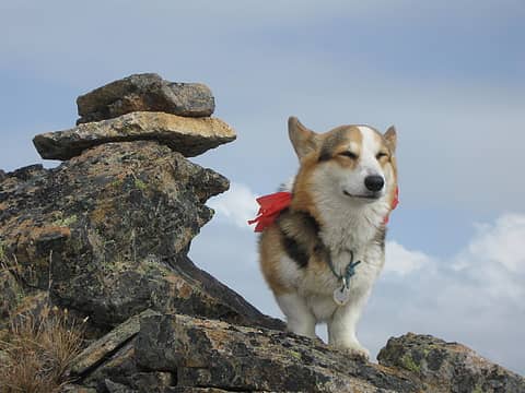
Gwynnie on Fortress Mt.
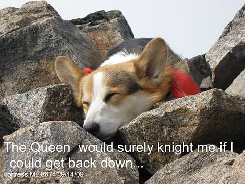
Fortress summit.
Fortress summit.
Spider Gap-Buck Pass loop You gotta be insanely careful with a dog on stuff like that. They're stupid about rockfall. Be aware of High Hunt too, in late Sept. That whole area is a favorite of hunters -- for a thousand years at least.

Some people have better things to do with their lives than walking the dog. Some don't.
Back to top Reply to topic Reply with quote Send private message
   All times are GMT - 8 Hours
 Reply to topic
Forum Index > Trip Reports > (Marmot) Fortress Mt. & Massie High Route 08_25-26_2012
Jump to:   
Search this topic:

You cannot post new topics in this forum
You cannot reply to topics in this forum
You cannot edit your posts in this forum
You cannot delete your posts in this forum
You cannot vote in polls in this forum