| Previous :: Next Topic |
| Author |
Message |
GeoTom
Member

Joined: 19 May 2005
Posts: 3215 | TRs | Pics
Location: Earth |
|
GeoTom
Member
|
 Wed Aug 29, 2012 5:17 pm |
|
|
Beep! Beep! Beep!
Huh? Why is the alarm clock going off at 2:30 am? Oh, yeah, I'm heading to the Pasayten today. Maybe I should have driven over there last night...
After being rudely awakened by my alarm clock, I gathered myself enough to mainline some coffee, put some clothes on and get the car out of the garage without hurting anyone. Dani had already left for the cabin for a girls weekend of pillowfighting and taken Jasper with her, so I had decided to head to the Pasayten to climb a few peaks. She even left one CD in the car. Hmm...Static X. At least it would help keep me awake during the drive.
I had never been to Harts Pass or Slate Pass before, so the drive would be a treat. The Civic handled it just fine as I zoomed past Deadhorse Point with my eyes closed and continued on into the clouds and snow at Slate Pass. Wait, snow? Had Augtober arrived already? Fortunately it was only snowing lightly and after a few minutes of waiting in the car it stopped and a brighter section of clouds appeared overhead.
The trail started out by immediately descending several hundred feet. By my calculations that meant that I would have to ascend that same part on the way out. Crap. Well, no time to worry about that now. I had to keep hiking as I only had 12 hours of sunlight left.
I continued on the trail, turning right towards the Middle Fork Pasayten River then another several miles downstream. I hadn't seen anyone all day until just before the junction with the trail to Shellrock Pass. Two older guys (heck, they were at least 43 if they were a day) were heading in the other direction. One of them gave me the stink eye so I gave him the crook eye. They kept coming, so I dropped one of my trekking poles and flashed the secret sign. They backed off after recognizing me a former Van Buren Boy and continued on their way. Unfazed, I started up the 476 (a rough estimate) switchbacks to Freds Lake and then up the 119 (an even rougher estimate) switchbacks to the saddle where I was treated to views of some of the peaks I hoped to climb.
The spur trail to Lake Doris appeared on the left, so I took it and found a decent spot to set up my camp for the next couple days. I saw two other tents closer to the lake, but didn't see anyone in them as I went through their stuff looking for better food or booze. I topped off my water containers from the lake, hung the food and decided to head up Osceola Peak since it was so close and dinner wouldn't be served for at least a couple hours.
As I started out from camp I heard some voices and saw a couple people on the slope above me. I moved a little bit to avoid any potential rockfall and continued my ascent up the southwest ridge of Osceola Peak. Suddenly I ran out of mountain (well, peak) to climb, so I stopped for a while to catch my breath, admire the views and write my life story in the summit register. I noticed that a family of 4 had signed it earlier in the day and figured it was who I saw coming down. Imagine that, teenage kids climbing peaks in the Pasayten when they could be sending text messages and updating Facebook. Say, that's a good idea. Where did I pack that phone?
After a satisfying break on the summit, I returned more or less the same way to camp. Since my camp cook hadn't arrived yet I decided to get things started on my own. While going to the lake to get water I saw 3/4 of the family (mom, dad and son) at one of their tents and chatted with them for a few minutes. They apologized for being so loud (they weren't) and we determined that we would have a similar itinerary the following day. I wished them well and returned to my camp for dinner. Some cabernet sauvignon and a mini toblerone topped off my feeding frenzy and I sat out to watch the sun dip below the ridgeline and enjoyed the changing color on the mountains above.
Photos from day 1:
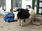
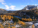
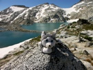
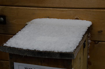 It was snowing lightly as I arrived at Slate Pass 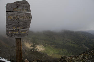 The journey begins 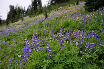 Lots of lupine (and friends) 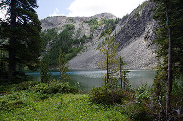 He was kind enough to let me walk by 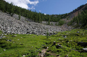 Basin above Freds Lake 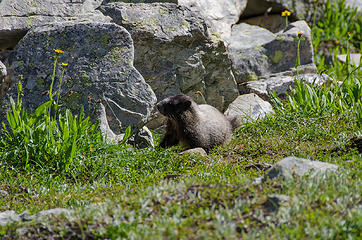 Marmot about to descend back into the hole 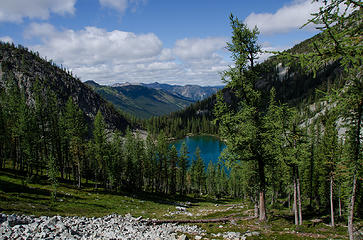 Above Freds Lake 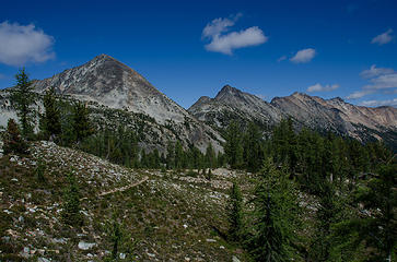 Osceola Peak, Mt. Carru and Mt. Lago 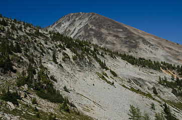 Osceola Peak from near my camp 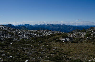 Views westward 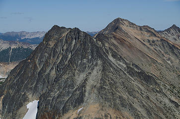 Mt. Carru and Mt. Lago from Osceola Peak 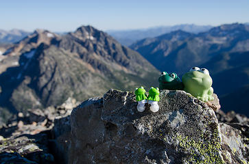 Osceola amphibians 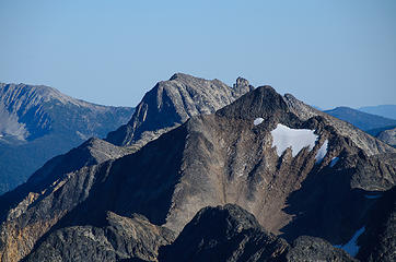 Lake Mountain behind Blackcap Mountain 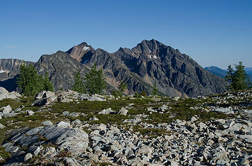 Blackcap and Monument again 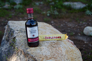 After dinner treats 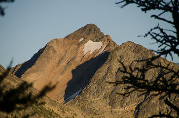 Late afternoon sun on Blackcap Mountain 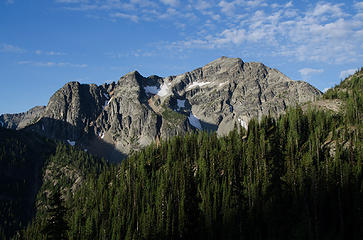 Mt. Rolo in the morning 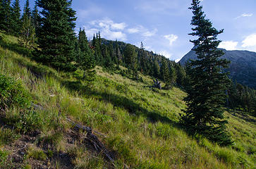 Ok, so there are a few trees 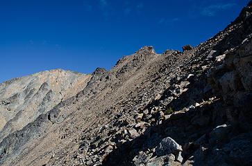 Oh, the summit is over there... 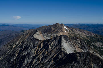 Ptarmigan Peak and Dot Mountain from Mt. Lago 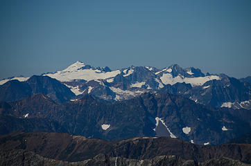 Inspiration 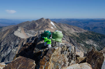 Mountain Fragos 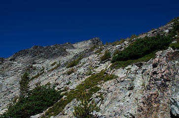 Now, Mt. Carru 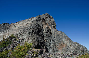 Stay left 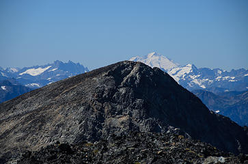 Mt. Baker peeking out over Osceola Peak 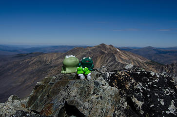 The family Carru 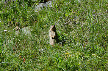 Hello! 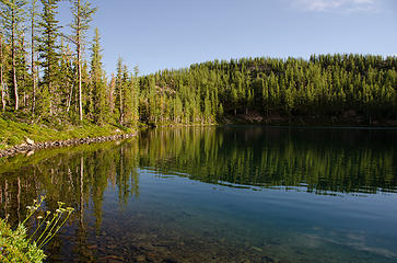 Sorry ladies, no photos of me swimming.  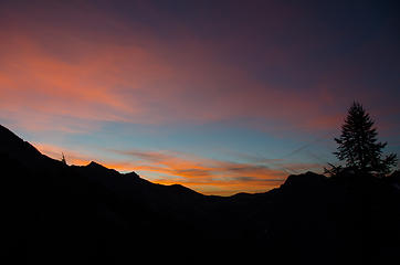 Tom take warning? 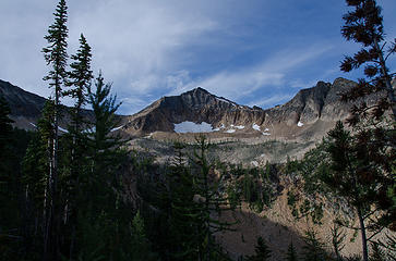 Nearing Blackcap Mountain 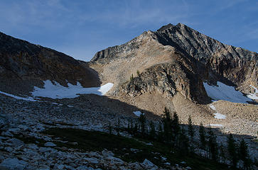 Probably the most fun scramble of the 4 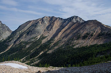 Mt. Lago from partway up Blackcap Mountain 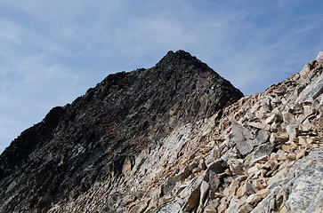 It really has a black cap 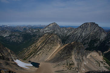 Osceola and Carru from Blackcap 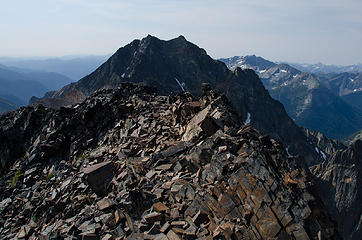 Monument Peak is a bit taller. 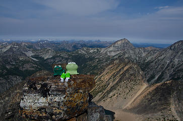 Greencap Mountain 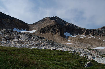 Back in the basin 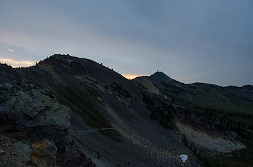 I made it back to the car without needing my headlamp.
|
| Back to top |
  
|
|
Mike Collins
Member

Joined: 18 Dec 2001
Posts: 3097 | TRs | Pics
|
|
| Back to top |
|
|
Yet
Member

Joined: 23 Apr 2005
Posts: 2634 | TRs | Pics
Location: Happily Ever After |
|
Yet
Member
|
Wed Aug 29, 2012 5:38 pm |
|
|
Nice!  Fun to read TR!
|
| Back to top |
|
|
RichP
Member

Joined: 13 Jul 2006
Posts: 5634 | TRs | Pics
Location: here |
|
RichP
Member
|
Wed Aug 29, 2012 5:39 pm |
|
|
That is such a grand area. I'm about due for another trip there.
It looks like the fire in Monument Ck fizzled out. Did you see any smoke?
|
| Back to top |
|
|
Joe
Member
Joined: 29 Jun 2002
Posts: 819 | TRs | Pics
Location: Kent |
|
Joe
Member
|
Wed Aug 29, 2012 6:03 pm |
|
|
GeoTom wrote a TR  . Your photos are great.
I need to make another trip Lake Doris. . Your photos are great.
I need to make another trip Lake Doris.
|
| Back to top |
|
|
twodogdad
Member
Joined: 21 Nov 2006
Posts: 846 | TRs | Pics
Location: seattle |
Goof job, Tom! Last year I went up the same gully, climbed East/?/ Lago, and the heat got me. Where is Jasper? N
|
| Back to top |
|
|
almosthere
Member

Joined: 06 Nov 2011
Posts: 54 | TRs | Pics
Location: the land of many uses |
| GeoTom wrote: | | One of them gave me the stink eye so I gave him the crook eye. |
thats rich.. 
|
| Back to top |
|
|
D. Inscho
Not bored yet...

Joined: 28 Feb 2010
Posts: 973 | TRs | Pics
Location: Bellingham,WA |
|
D. Inscho
Not bored yet...
|
Wed Aug 29, 2012 9:34 pm |
|
|
I LOVE DORIS! There I said it, been with her twice...
Super fun read about my favorite area in The Pasayten.
He was kind enough to let me walk by
http://david-inscho.smugmug.com/
The key to a successful trip is to do the planning during work hours. -- John Muir
My most memorable hikes can be classified as 'Shortcuts that Backfired'. --Ed Abbey
http://david-inscho.smugmug.com/
The key to a successful trip is to do the planning during work hours. -- John Muir
My most memorable hikes can be classified as 'Shortcuts that Backfired'. --Ed Abbey
|
| Back to top |
|
|
GeoTom
Member
Joined: 19 May 2005
Posts: 3215 | TRs | Pics
Location: Earth |
|
GeoTom
Member
|
Thu Aug 30, 2012 4:47 am |
|
|
Rich-
I didn't notice any smoke from that fire. Hopefully it has fizzled out. I'd like to pay a visit to that drainage sometime in September or October. Monument looks like it could be a lot of fun.
Niko-
Jasper had his paws full at the cabin with his mama and several of his 'aunts'. He could probably have handled any of these peaks (well, maybe not the top of Blackcap), but doing all 4 in 3 days would have been a bit much for his little paws with all that talus and scree.
|
| Back to top |
|
|
Bedivere
Why Do Witches Burn?

Joined: 25 Jul 2008
Posts: 7464 | TRs | Pics
Location: The Hermitage |
|
Bedivere
Why Do Witches Burn?
|
Thu Aug 30, 2012 6:28 am |
|
|
Sweet TR! I was just up in that area two weeks ago, still haven't written the TR about it...
I hear ya about Jasper's paws. The trip I did was one of the few where Jack didn't summit everything I did. The dogs' paws were getting pretty worked over so they got enforced rest days guarding our campsite while we went off to climb. Lots of sharp rocks around there.
Interesting to see snow upon your arrival. Slate Pass *is* just about 7K ft but it's been so warm lately that I wouldn't have expected that. Heck, before you know it, it'll be Larch season.
|
| Back to top |
|
|
TrailPair
Member

Joined: 17 Apr 2005
Posts: 1699 | TRs | Pics
|
Kolleen and I did Ptarmigan Peak a few years ago.....After reading your report and viewing your photos, we don't have to go back for Lago, Caru, etc....we can live vicarioulsy through your adventure 
This thing called work is interfering with my play
This thing called work is interfering with my play
|
| Back to top |
|
|
wildernessed
viewbagger

Joined: 31 Oct 2004
Posts: 9275 | TRs | Pics
Location: Wenatchee |
Nice TR and pics Tom !
Living in the Anthropocene
Living in the Anthropocene
|
| Back to top |
|
|
twodogdad
Member
Joined: 21 Nov 2006
Posts: 846 | TRs | Pics
Location: seattle |
| GeoTom wrote: | | Jasper had his paws full at the cabin with his mama and several of his 'aunts'. He could probably have handled any of these peaks (well, maybe not the top of Blackcap), but doing all 4 in 3 days would have been a bit much for his little paws with all that talus and scree. |
I forgot he's a bit too large to carry in your backpack And who'd rather not have his paws full of mama and aunts.
FWIW I too was surprised--and not surprised--to see that snow. A couple of years ago in mid September the dogs and I went to Osceola: my plan was to do several peaks but it got so cold the first night at Lake Doris that we had to turn back for their sake--or mine. They made their opinion clear by usurping my sleeping bag (which can accommodate one but not two). Ice (frozen mud) on talus was hard on their paws.
N
|
| Back to top |
|
|
GaliWalker
Have camera will use

Joined: 10 Dec 2007
Posts: 4930 | TRs | Pics
Location: Pittsburgh |
|
GaliWalker
Have camera will use
|
Thu Aug 30, 2012 5:31 pm |
|
|
| GeoTom wrote: | | She asked if I was hot. I thought, well, my wife must think I am, but then I realized that she was referring to my attire. |
So many good bits in this one. Excellent report!
|
| Back to top |
|
|
Slide Alder Slayer
Member
Joined: 14 Jan 2002
Posts: 1960 | TRs | Pics
|
Thank you for posting an excellent trail report!
|
| Back to top |
|
|
|
|
You cannot post new topics in this forum
You cannot reply to topics in this forum
You cannot edit your posts in this forum
You cannot delete your posts in this forum
You cannot vote in polls in this forum
|
Disclosure: As an Amazon Associate NWHikers.net earns from qualifying purchases when you use our link(s). |


