| Previous :: Next Topic |
| Author |
Message |
mtnresqr
Member


Joined: 18 May 2010
Posts: 48 | TRs | Pics
|
|
mtnresqr
Member
|
 Mon Sep 24, 2012 11:02 am |
|
|
The three year contract build of New Pratt Connector trail is done. Contractors have left. It is not officially turned-over to 'finished' so may need some final 'polishing'. Trail is built to stock standards, so the grade is nice and 4 feet wide.
This trail connects the Gateway Bridge at Middle Fork T/H to meeting with the Main Pratt River trail in 3.5 miles. Then the main Pratt trail has been brushed out some, and in two miles one reaches the actual RR Grade trail of the Pratt. This was built and logged in 1937-1940. RR heads up the Pratt Valley, on 7 miles of RR grade to just two miles below Pratt Lake outlet.
Then there is a trail from there up to Pratt Lake which needs some work to 'define' the Pratt river crossing area.
The Pratt logging RR grade is almost two lanes wide and is a moss-covered road/tunnel through 70 year old second growth trees. When logging was finished, they took up the rails and left just the ties. Sometimes there is brush on RR grade when there are places with 'open sky' allowing sunlight in to grow brush, but most of it is just ferns and moss.
The whole "Pratt River trail was 16 miles from 'old' US-10 (now I-90) through to connect with original Middle Fork trail, which ran from North Bend to Goldmyer Hot Springs. That was originally called just that, the "North Bend-Hot Springs trail", back in 1897. For many years, the way to get the Middle Fork end resolved, one had to wade the Middle Fork river, since the Middle Fork trail had faded into brushy. and wading was only possible in full summer when river was low enough to wade. Now we have a 3 mile trail for year-round access to the Pratt trail.
Some day the maps may get the full trail listed, also. It is shown in full on NW trails for incorporating onto GPS maps. All nineteen miles of it.
|
| Back to top |
  
|
|
iron
Member

Joined: 10 Aug 2008
Posts: 6392 | TRs | Pics
Location: southeast kootenays |
|
iron
Member
|
Tue Sep 25, 2012 10:26 am |
|
|
thanks for the update. is there any way to include a rough sketch of where the new trail runs?
|
| Back to top |
|
|
Kim Brown
Member
Joined: 13 Jul 2009
Posts: 6899 | TRs | Pics
|
Anyone interested in this trail should come to REI tomorrow night - WTA is hosting a "Hiker Potluck." Meet MBS land managers - including Jim Franzel of North Bend, and Gary Paull, who will tell us all about this new trail and other way cool stuff (and maybe some not way cool stuff).
REI Seattle
Wednesday Sept 26 6:30 - 8:00.
Bring food.
"..living on the east side of the Sierra world be ideal - except for harsher winters and the chance of apocalyptic fires burning the whole area."
Bosterson, NWHiker's marketing expert
"..living on the east side of the Sierra world be ideal - except for harsher winters and the chance of apocalyptic fires burning the whole area."
Bosterson, NWHiker's marketing expert
|
| Back to top |
|
|
whitebark
Member

Joined: 08 Jul 2005
Posts: 1864 | TRs | Pics
Location: Seattle |
Wow, that's great news! I've gotta check out the new Pratt River connector soon.
|
| Back to top |
|
|
cambajamba
Member
Joined: 05 Nov 2011
Posts: 339 | TRs | Pics
|
This is awesome...like a hundred million hotdogs. Can't wait to check it out!
|
| Back to top |
|
|
-lol-
Member
Joined: 17 Dec 2001
Posts: 767 | TRs | Pics
|
|
-lol-
Member
|
Tue Sep 25, 2012 8:46 pm |
|
|
|
| Back to top |
|
|
puzzlr
Mid Fork Rocks

Joined: 13 Feb 2007
Posts: 7220 | TRs | Pics
Location: Stuck in the middle |
|
puzzlr
Mid Fork Rocks
|
Wed Sep 26, 2012 1:26 am |
|
|
Iron, here's a map from the FS contract. The new trail connects the main Middle Fork trail head (at the Gateway Bridge) to the old Pratt trail/road/railroad grade. The new trail is very nice, done by the same group that did the Kendall Katwalk years ago (Trio Construction). Lots of clearing has been going on beyond the end of the contract section.
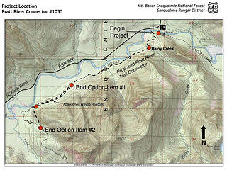 Pratt Connector trail map from the Forest Service contract document. Update 6 years later - This trail has been built and has been in use for several years now. It's a great walk and provides reasonably easy access to the Pratt Valley. 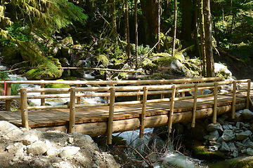 Rainy Creek bridge 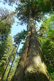 Big tree 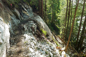 New trail, not done yet 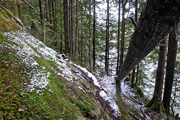 Same spot, before 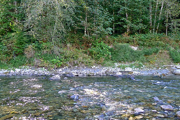 3 labels Flagging on the far side. There's a cut in the bank there to get up, then a very short cleared trail to the Pratt Connector
|
| Back to top |
|
|
Navy salad
Member

Joined: 09 Sep 2008
Posts: 1865 | TRs | Pics
Location: Woodinville |
| puzzlr wrote: | Pratt Connector trail map from the Forest Service contract document. Update 6 years later - This trail has been built and has been in use for several years now. It's a great walk and provides reasonably easy access to the Pratt Valley. |
I looked up this area in Northwest Topos and saw that they already show a connector trail on their map for this location. Perhaps someone walked through the proposed route and then uploaded the GPS track to NW Topos?
|
| Back to top |
|
|
puzzlr
Mid Fork Rocks
Joined: 13 Feb 2007
Posts: 7220 | TRs | Pics
Location: Stuck in the middle |
|
puzzlr
Mid Fork Rocks
|
Wed Sep 26, 2012 10:21 pm |
|
|
There has always been a trail along that side of the river - hence a user contribution to NW Topo. The new trail takes a different route for the first half mile to cross Rainy Creek in a better spot, but other than that it's mostly the same line. In the old old pre-logging days the primary trail went up the south side of the river there, after a stopping at the "Halfway House" by the Pratt confluence. More recently, until 1975 there was a cable bridge across the Middle Fork so that trail saw little use. The combination of no cable bridge, a hard-to-follow old connector, and overgrown sections of the Pratt valley trail did not encourage access into the Pratt. This trail may change that pattern, at least for those that like long valley bottom walks.
 Halfway House 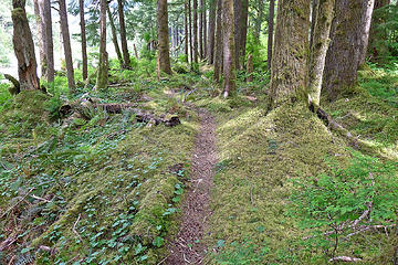 Old Pratt Connector trail, close to the river 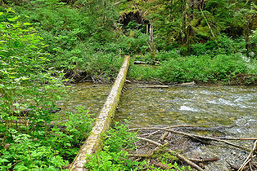 Old Rainy Creek bridge (different spot)
|
| Back to top |
|
|
|
|


