| Previous :: Next Topic |
| Author |
Message |
Scrooge
Famous Grouse


Joined: 16 Dec 2001
Posts: 6966 | TRs | Pics
Location: wishful thinking |
|
Scrooge
Famous Grouse
|
 Mon Nov 19, 2012 10:11 am |
|
|
Reprise .... I left Wenatchee in light snow, but the day got better as it went along.
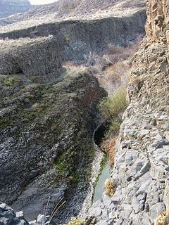
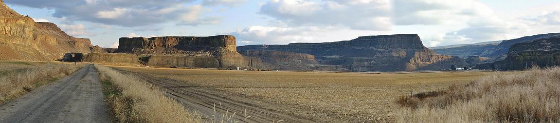 Putting it in perspective, Moses Coulee, the Billingsley Ranch, and Rattlesnake Canyon (on the far left). 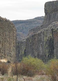 Approaching a slot 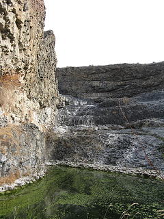 The bitter end? 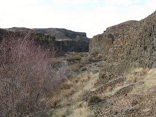 I love deer tracks  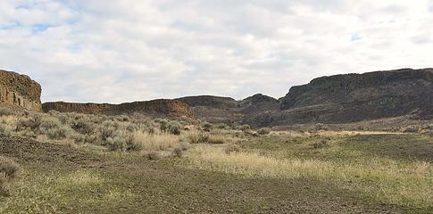 On top of the cliff, a different world 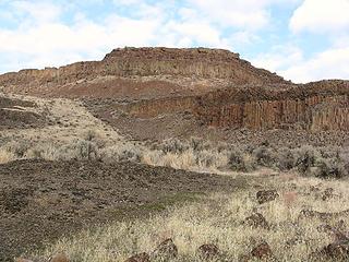 But still deep in the canyon 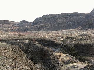 Ordinary erosion in basalt 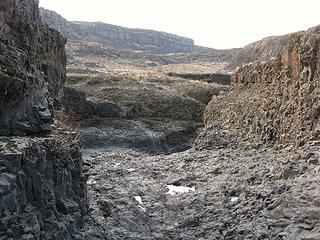 In the bed of the Rattlesnake 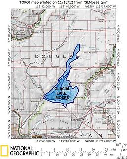 Glacial Lake Moses - size uncertain  Cross-section, coulee versus canyon 
 Cross-section, Moses Coulee versus Rock Island Creek Canyon  They're real cross-sections, chosen because they're roughly the same width and height ..... and for effect. They're real cross-sections, chosen because they're roughly the same width and height ..... and for effect.  Rock Island Creek's the next Columbia tributary north of Moses Coulee. The cross-section was from a spot 3 or 4 miles up its canyon. The Moses Coulee cross-section is from somewhere around Palisades. ..... Errr. ..... Back to the hike.
 Top of the stain 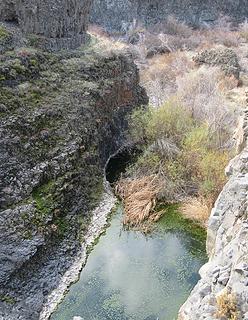 Man, I hate this. - Bitter end from above 
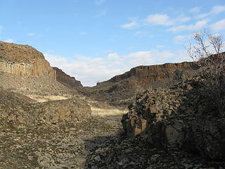 Heading upstream - Note the sloping walls. 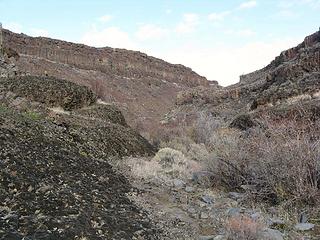 Baby canyon, with brush 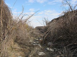 Lots of brush 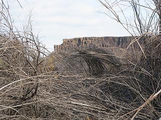 Streambed brush 
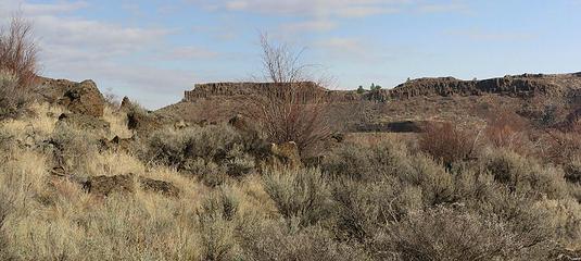 Rattlesnake amphitheater. It doesn't feel like a canyon 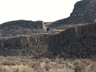 But it is. Rattlesnake Falls 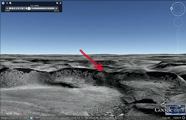 Rattlesnake Falls 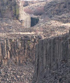 Rattlesnake Falls  Rattlesnake Creek profile 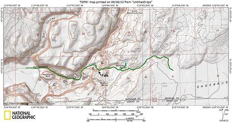 Rattlesnake Creek 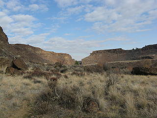 McCarteney Creek Canyon mouth 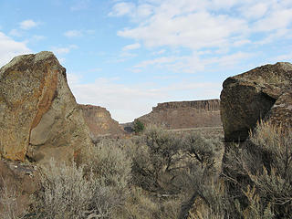 McCarteney Creek Canyon portals  I head upstream towards the mouth of McCarteney Creek Canyon.
But I think that better wait for Part III. I head upstream towards the mouth of McCarteney Creek Canyon.
But I think that better wait for Part III. 
Something lost behind the ranges. Lost and waiting for you....... Go and find it. Go!
Something lost behind the ranges. Lost and waiting for you....... Go and find it. Go!
|
| Back to top |
  
|
|
wolffie
Member

Joined: 14 Jul 2008
Posts: 2693 | TRs | Pics
Location: Seattle |
|
wolffie
Member
|
Tue Nov 20, 2012 11:51 pm |
|
|
There's an obvious "bathtub ring" at Ancient Lakes (at least on one of them, the lower). Do you know why? I believe they drain to the Columbia. Did the Missoula Floods run down the Columbia and dam this drainage with a lateral rubble pile or something that's slowly being eroded through? Or does the lake level simply fluctuate with rainfall variations?
What's the date range of the Missoula Floods?
Approximately when is the rattlesnake season out there?
With my young daughter at Vantage once (Spring), I was alarmed to see a small diamondback quite close. I whisked the kid away, then noticed that this was a garter snake in diamondback drag. Rattlesnake color, diamondback pattern, head just like a garter snake, clearly not a rattler. Anybody know the name of this species? Or is it just a race of garter snakes who've figured out that if you're not dangerous, it pays to look like you are?
Some people have better things to do with their lives than walking the dog. Some don't.
Some people have better things to do with their lives than walking the dog. Some don't.
|
| Back to top |
|
|
Scrooge
Famous Grouse
Joined: 16 Dec 2001
Posts: 6966 | TRs | Pics
Location: wishful thinking |
|
Scrooge
Famous Grouse
|
Wed Nov 21, 2012 6:44 am |
|
|
wolffie, you don't know it, but you're essentially asking for the whole history of the channeled scablands and the discovery of the Missoula Floods. The story started at Potholes Coulee! Rather than me trying to give it to you, I suggest that you do some reading. ..... I think you'll enjoy it.
Go to our main section on Coulee Country and the channeled scablands and look at the bibliography in the wiki (at the top of each page). The book you want is "Cataclysms on the Columbia". It's a good read.
And I'm sorry, but I don't know the answers to your snake questions.
Something lost behind the ranges. Lost and waiting for you....... Go and find it. Go!
Something lost behind the ranges. Lost and waiting for you....... Go and find it. Go!
|
| Back to top |
|
|
treeswarper
Alleged Sockpuppet!

Joined: 25 Dec 2006
Posts: 11276 | TRs | Pics
Location: Don't move here |
|
treeswarper
Alleged Sockpuppet!
|
Wed Nov 21, 2012 7:19 am |
|
|
The common, locally used name for that snake is Bull Snake.
What's especially fun about sock puppets is that you can make each one unique and individual, so that they each have special characters. And they don't have to be humananimals and aliens are great possibilities
What's especially fun about sock puppets is that you can make each one unique and individual, so that they each have special characters. And they don't have to be humananimals and aliens are great possibilities
|
| Back to top |
|
|
wolffie
Member
Joined: 14 Jul 2008
Posts: 2693 | TRs | Pics
Location: Seattle |
|
wolffie
Member
|
Wed Nov 21, 2012 12:10 pm |
|
|
I do not think it was a bull snake. Smaller, different behavior, shaped exactly like a garter snake. Although I've only seen bull snakes in Utah, and they may have different coloration there. I thought this one was like a subspecies of garter snakes mimicking rattlers.
Thanks Scrooge, got my holiday reading now.
Some people have better things to do with their lives than walking the dog. Some don't.
Some people have better things to do with their lives than walking the dog. Some don't.
|
| Back to top |
|
|
Z
Erratic
Joined: 28 Jan 2008
Posts: 797 | TRs | Pics
Location: Greater Orondo area |
|
Z
Erratic
|
Wed Nov 21, 2012 3:00 pm |
|
|
| wolffie wrote: | | There's an obvious "bathtub ring" at Ancient Lakes (at least on one of them, the lower). Do you know why? |
Ancient Lake (singular!) was filled for several years (60+ years ago) by excess water from the basin irrigation project. Now only the potholes are left (thus Potholes Coulee). If you go down the old wagon road (just south of the outlet from Ancient Lake), you'll see the big washout from that time. It took out a section of old road, so you can tell it's postdiluvian (if that's a real word-but it should be).
P.S. Bull Snake
"Einstein stating that nothing can travel faster than the speed of light, is as a blind man stating that nothing can travel faster than the speed of sound" 1979
They don't make years like they used to.
"Einstein stating that nothing can travel faster than the speed of light, is as a blind man stating that nothing can travel faster than the speed of sound" 1979
They don't make years like they used to.
|
| Back to top |
|
|
Scrooge
Famous Grouse

Joined: 16 Dec 2001
Posts: 6966 | TRs | Pics
Location: wishful thinking |
|
Scrooge
Famous Grouse
|
Wed Nov 21, 2012 3:34 pm |
|
|
wolffie, treeswarper grew up in that canyon. She's worked her whole life in the outdoors, I believe as a forester working for the timber industry. You can bet on that bull snake.
Something lost behind the ranges. Lost and waiting for you....... Go and find it. Go!
Something lost behind the ranges. Lost and waiting for you....... Go and find it. Go!
|
| Back to top |
|
|
Scrooge
Famous Grouse

Joined: 16 Dec 2001
Posts: 6966 | TRs | Pics
Location: wishful thinking |
|
Scrooge
Famous Grouse
|
Wed Nov 21, 2012 3:46 pm |
|
|
| Z wrote: | | wolffie wrote: | | There's an obvious "bathtub ring" at Ancient Lakes (at least on one of them, the lower). Do you know why? |
Ancient Lake (singular!) was filled for several years (60+ years ago) by excess water from the basin irrigation project. Now only the potholes are left (thus Potholes Coulee) |
However, the level also varies throughout the year. Note that there is an active, year-round stream flowing into both Ancient Lake and Dusty Lake, but no outlet, for either one. Drainage is through the flood gravel that fills what were plunge pools in both coulees, extending, I believe, all the way out to the edge of Babcock Bench.
Z, you're explanation is right; it's just not complete.
Something lost behind the ranges. Lost and waiting for you....... Go and find it. Go!
Something lost behind the ranges. Lost and waiting for you....... Go and find it. Go!
|
| Back to top |
|
|
GeoHiker
Rocky Walker
Joined: 26 Feb 2005
Posts: 6033 | TRs | Pics
Location: Off the Deep End |
|
GeoHiker
Rocky Walker
|
Thu Nov 22, 2012 12:49 am |
|
|
More good work Scrooge.  You're really getting around over there. Most of the lakes in central E.WA are much lower than they were 20-30 years ago due to increased irrigation and improved maintenance on leaking canals. Water quality has suffered as well. You can see the alkali high water mark through out E.WA.
It's not unheard of that a rattler loses it's rattle. I came across a 5 fter that lost it's rattle and just about scared the beejeezers out of me. I'd guess a bull snake though. I've seen rattlers from early March- through Nov. I came across a snake ball at Banks Lk a week after having knee surgery, so that would have put it early March. They were quite active and I know I can jump 5 ft. straight up when need be!....... You're really getting around over there. Most of the lakes in central E.WA are much lower than they were 20-30 years ago due to increased irrigation and improved maintenance on leaking canals. Water quality has suffered as well. You can see the alkali high water mark through out E.WA.
It's not unheard of that a rattler loses it's rattle. I came across a 5 fter that lost it's rattle and just about scared the beejeezers out of me. I'd guess a bull snake though. I've seen rattlers from early March- through Nov. I came across a snake ball at Banks Lk a week after having knee surgery, so that would have put it early March. They were quite active and I know I can jump 5 ft. straight up when need be!.......
You call some place paradise, kiss it goodbye......Eagles
You call some place paradise, kiss it goodbye......Eagles
|
| Back to top |
|
|
wolffie
Member
Joined: 14 Jul 2008
Posts: 2693 | TRs | Pics
Location: Seattle |
|
wolffie
Member
|
Thu Nov 22, 2012 2:30 pm |
|
|
Anecdote from Utah, in December:
Andy, climbing a cliff, reaches up to mantle onto the ledge above, withdraws his gooey hand in disgust:
ANDY: "Yuck! What's this sh!t?"
WENDY: "It's rattlesnake sh!t, Andy."
ANDY (irritated): "And how do YOU know what kind of sh!t it is?!"
WENDY (patient, all-suffering voice): "Because the rattlesnake is sitting right next to it, Andy."
The snake had been warming itself in its habitual spot in the sun, but apparently got caught by the afternoon shadow, and was now so cold it was immobile. Fortunately.
We blundered into a bull snake once in Canyonlands. It reared up, mouth wide agape, hissing loudly (sounds just like a rattle), proving that you don't have to be venomous to make people run 30' in 3 paces. I was brown, not the sage-green I recall in the Vantage snake. Wide variety in coloration would not be surprising.
9/1/12 in the Pasayten, I met 2 hikers who'd just seen a two-headed snake. I asked if they had any more of that good stuff they'd been smokin'. When *I* start seeing 2-headed snakes, I go home. Turns out, 2-headed snakes are rare but not unheard-off (google it), both Y-shaped and one head at either end.
Some people have better things to do with their lives than walking the dog. Some don't.
Some people have better things to do with their lives than walking the dog. Some don't.
|
| Back to top |
|
|
wolffie
Member
Joined: 14 Jul 2008
Posts: 2693 | TRs | Pics
Location: Seattle |
|
wolffie
Member
|
Mon Dec 03, 2012 7:54 pm |
|
|
I just flew over all this stuff 2 days after finishing Cataclysms on the Columbia! Saw gravel bars near Spokane; Grand Coulee; Quincy Basin. Best of all: the plane had real-time google earth flight maps, so I knew exactly where we were; the overcast was so thin that it cleared when it dipped into the Clark Fork valley, and I saw ripple marks in the lakebed of Glacial Lake Missoula, pretty sure.
If you ever fly Minneapolis <--> SeaTac, get the earliest flight with a window seat. We left Minneapolis 9:00 AM CST . In December, the sun is still low enough to cast shadows at that time, even on the subtle terrain of the Dakotas and eastern Montana. I prefer a north-side seat (downsun), but it's a toss-up. This flight went smack dab over the channeled scablands, N of Eephrata, just S of Spokane, S end of Grand Coulee, barely S of Chelan. Sometimes you get lucky and the Cascades are clear. W --> E, the route is more southerly; a starboard seat gives a good volcano view, but you'll miss most of the scablands.
Long summer days, get the 6 AM flight out of MSP with a starboard seat, and you'll land with a stiff neck and be happy about it.
Some people have better things to do with their lives than walking the dog. Some don't.
Some people have better things to do with their lives than walking the dog. Some don't.
|
| Back to top |
|
|
|
|
You cannot post new topics in this forum
You cannot reply to topics in this forum
You cannot edit your posts in this forum
You cannot delete your posts in this forum
You cannot vote in polls in this forum
|
Disclosure: As an Amazon Associate NWHikers.net earns from qualifying purchases when you use our link(s). |


