| Previous :: Next Topic |
| Author |
Message |
Chris S
Member


Joined: 08 Sep 2013
Posts: 3 | TRs | Pics
|
|
Chris S
Member
|
 Fri Oct 25, 2013 7:31 am |
|
|
Not to resurrect an old thread, but I was doing some trail research for this weekend and found this. I just read 3+ pages of bitching stretched out over 4 months and not one of you reported trying to call the land manager, whether it be DNR or USFS, to ask what their plan and priorities were when they decommissioned this road and turned it into a trail. Wouldn't that be a logical next step instead of endless theories?
|
| Back to top |
  
|
|
suziq999
Member
Joined: 25 Sep 2013
Posts: 164 | TRs | Pics
Location: United States |
|
suziq999
Member
|
Fri Oct 25, 2013 8:31 am |
|
|
I just wanted to point out that I spit out a perfectly good mouthful of pumpkin spice latte laughing so hard at this picture:
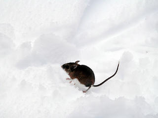 Save me from these sh*tty trail improvements!
|
| Back to top |
|
|
tigermn
Member

Joined: 10 Jul 2007
Posts: 9242 | TRs | Pics
Location: There... |
|
tigermn
Member
|
Fri Oct 25, 2013 9:11 am |
|
|
| Chris S wrote: | | I just read 3+ pages of bitching stretched out over 4 months and not one of you reported trying to call the land manager, whether it be DNR or USFS, to ask what their plan and priorities were when they decommissioned this road and turned it into a trail. Wouldn't that be a logical next step instead of endless theories? |
But that wouldn't be any fun. Seriously I don't really have a problem with the new "trail" since I have hiked it. Did they need to do this? Heck no but... Would have rather seen resources used elsewhere.
|
| Back to top |
|
|
Kim Brown
Member
Joined: 13 Jul 2009
Posts: 6900 | TRs | Pics
|
| tigermn wrote: | | Did they need to do this? Heck no but. |
If you know they didnt need to do this, please elaborate so we all know they didnt need to do this.
Often, a land manager needs to do something in order to fulfill an obligation to the public in exchange for something else. It could be that they need to provide better trails that lead into Wilderness as the public wanted them to do in the original ALW plan. It could be that they need to restore the roadbed for environmental reasons that folks know nothing about, but should by now theres plenty of information out there about the impacts of roads on the environment (I'm still waiting to read a NWHiker peer-reviewed report about roads not having any impact - until it's published and generally accepted by scientists who do this for a living, I'm in the restoration school).
"..living on the east side of the Sierra world be ideal - except for harsher winters and the chance of apocalyptic fires burning the whole area."
Bosterson, NWHiker's marketing expert
"..living on the east side of the Sierra world be ideal - except for harsher winters and the chance of apocalyptic fires burning the whole area."
Bosterson, NWHiker's marketing expert
|
| Back to top |
|
|
Schroder
Member

Joined: 26 Oct 2007
Posts: 6723 | TRs | Pics
Location: on the beach |
|
Schroder
Member
|
Fri Oct 25, 2013 10:58 am |
|
|
| The Angry Hiker wrote: | 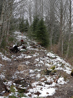 Is this really necessary? |
Roads may be decommissioned for many reasons, but the trail design is ridiculous. I'm seeing this many places now. What's wrong with a straight trail?
|
| Back to top |
|
|
Kim Brown
Member
Joined: 13 Jul 2009
Posts: 6900 | TRs | Pics
|
Straight trails are uninteresting and over time become flumes for water; meandering trails give opportunities for swales, drain dips and other trail features which are easier to maintain than an eroded flume.
The meander in the photo looks a bit odd; too much wiggle, I think. But that does not mean converting the road to a trail isn't needed. 
"..living on the east side of the Sierra world be ideal - except for harsher winters and the chance of apocalyptic fires burning the whole area."
Bosterson, NWHiker's marketing expert
"..living on the east side of the Sierra world be ideal - except for harsher winters and the chance of apocalyptic fires burning the whole area."
Bosterson, NWHiker's marketing expert
|
| Back to top |
|
|
Schroder
Member
Joined: 26 Oct 2007
Posts: 6723 | TRs | Pics
Location: on the beach |
|
Schroder
Member
|
Fri Oct 25, 2013 11:39 am |
|
|
| Kim Brown wrote: | | Straight trails are uninteresting and over time become flumes for water |
I would disagree with that. Water follows the slope and the design for dealing with it is independent of a meandering or straight trail. As for uninteresting, a straight trail allows you to look at your surroundings rather than your feet. The trail in the photos is the ultimate of uninteresting - an endless series of short switchbacks.
|
| Back to top |
|
|
Voxxjin
made of hamburger

Joined: 05 Sep 2013
Posts: 657 | TRs | Pics
Location: Dupont |
|
Voxxjin
made of hamburger
|
Fri Oct 25, 2013 12:03 pm |
|
|
So on one of these meandering trails when you see milage signs (on a map or trail sign) is it straight trail milage or meanderign trail milage?
Also when they do these meandering trails, do people actually fo the back and forth or do they just straightline it? (and over time it becomes a straight trail?
Cry 'Havoc!' and let slip the dogs of war
Cry 'Havoc!' and let slip the dogs of war
|
| Back to top |
|
|
Kim Brown
Member
Joined: 13 Jul 2009
Posts: 6900 | TRs | Pics
|
| Schroder wrote: | | Kim Brown wrote: | | Straight trails are uninteresting and over time become flumes for water |
I would disagree with that. Water follows the slope and the design for dealing with it is independent of a meandering or straight trail |
Ah! I see what you're saying. it would depend on where its straight. If its a straight trail along a slope, yes, it is interesting and provides opportunities for a great trail that can direct water off it easily. I was thinking more of a straight up trail.
"..living on the east side of the Sierra world be ideal - except for harsher winters and the chance of apocalyptic fires burning the whole area."
Bosterson, NWHiker's marketing expert
"..living on the east side of the Sierra world be ideal - except for harsher winters and the chance of apocalyptic fires burning the whole area."
Bosterson, NWHiker's marketing expert
|
| Back to top |
|
|
boot up
Old Not Bold Hiker

Joined: 12 Dec 2006
Posts: 4745 | TRs | Pics
Location: Bend Oregon |
|
boot up
Old Not Bold Hiker
|
Fri Oct 25, 2013 12:19 pm |
|
|
It is designed perfectly to be a safe and interesting "technical single track" multi-use mtn bike trail, as they promised the mtn bike community it would be.
And since it is such a boring trail for hikers, apparently, there should not be that many hikers on it anyway.
Then in their infinite wisdom, they promptly banned bicycles. Which is pretty typical. 
|
| Back to top |
|
|
whitebark
Member

Joined: 08 Jul 2005
Posts: 1864 | TRs | Pics
Location: Seattle |
Are you sure? I think that bicycles are allowed on the trail
|
| Back to top |
|
|
boot up
Old Not Bold Hiker
Joined: 12 Dec 2006
Posts: 4745 | TRs | Pics
Location: Bend Oregon |
|
boot up
Old Not Bold Hiker
|
Fri Oct 25, 2013 2:16 pm |
|
|
| whitebark wrote: | | Are you sure? I think that bicycles are allowed on the trail |
it was open for about 2 weeks for bikes, until all the official signage went up.
|
| Back to top |
|
|
Ski
><((((°>

Joined: 28 May 2005
Posts: 12835 | TRs | Pics
Location: tacoma |
|
Ski
><((((°>
|
Fri Oct 25, 2013 2:24 pm |
|
|
| Schroder wrote: | | but the trail design is ridiculous. I'm seeing this many places now. |
somebody spent way too much time visiting Zen gardens.
have to wonder if part of the reason for the zig-zagging was to discourage bicycle/motorbike use.
"I shall wear white flannel trousers, and walk upon the beach.
I have heard the mermaids singing, each to each."
"I shall wear white flannel trousers, and walk upon the beach.
I have heard the mermaids singing, each to each."
|
| Back to top |
|
|
Randito
Snarky Member

Joined: 27 Jul 2008
Posts: 9513 | TRs | Pics
Location: Bellevue at the moment. |
|
Randito
Snarky Member
|
Fri Oct 25, 2013 3:58 pm |
|
|
| Ski wrote: | | zig-zagging was to discourage bicycle/motorbike use |
Or at least to discourage "Banzai!" style descents at high speed.
When the CCC was active in the '30s those work crews did a lot of things that weren't 100% necessary -- but that was sort of the point of that program. I wonder to what extent "Make Work" was a factor in this "decommissioning".
|
| Back to top |
|
|
Backpacker Joe
Blind Hiker

Joined: 16 Dec 2001
Posts: 23956 | TRs | Pics
Location: Cle Elum |
"If destruction be our lot we must ourselves be its author and finisher. As a nation of freemen we must live through all time or die by suicide."
Abraham Lincoln
|
| Back to top |
|
|
|
|


